
Where Flight Simulation Enthusiasts Gather from Around the World!
AVSIM Library - Search Results

| Category: Microsoft Flight Simulator (2020) - Utilities | |
| Additional Flightplan Visualizer Airline logos |

|
File Description:
This package contains +1400 addition airline logo's to use with the program Flightplan Visualizer (from version 1.22).
All the logo's are in a special ".CAL" format and can only be used with Flightplan Visualizer. To use these logos you must first download, install and run Flightplan Visualizer (at least version 1.22). You then need to copy all of the ".CAL" files to the folder below, where "[UserName]" have to be replaced by your actual windows username:
C:\Users\[UserName]\AppData\Roaming\FlightplanVisualizer\LogoCache
In stead of manually navigating to this folder, you can also run Flightplan Visualizer and use the menus "File" -> "UserData" which will open an explorer window with the "UserData" folder opened. You then just need to step back to the parent folder, and then open the "LogoCache" folder.
If you have AIG AIM installed on your computer you can in stead of this file, also use a new setting in version 1.22 of Flightplan Visualizer, and set a path to where AIG AIM stores its airline-logo graphic files
| Filename: | Additional_Flightplan_Visualizer_Airline_logos.zip |
| License: | Freeware, limited distribution |
| Added: | 18th October 2022, 23:32:02 |
| Downloads: | 146 |
| Author: | Pelle Liljendal |
| Size: | 60.77 MB |
| Category: Flight Simulator 2004 - AI Aircraft | |
| Israeli Air Force Part 6 - Tel Nof Air Base F-15 |
|
Images related to this file:
File Description:

Tel Nof Air Base was founded in July 1939 during the British Mandate as RAF Aqir and served as the main Royal Air Force station in Palestine. It is located near the "city of science" Rehovot in central Israel.
The base is the primary operational and training center for all IDF paratroop forces, as well as the home of Unit
699 (a.k.a. Maslul), the Israeli Defense Force Airborne Combat Search and Rescue (CSAR) unit under the Special
Air Force Command (KAHAM). The ORT Israel - the Administration for Research and Development and Training -
operates the Air Force Industry School at Tel Nof.
In addition to the two operational squadrons on F-15, Tel Nof is home to the MANAT evaluation unit which
conducts flight testing and evaluation of aircraft and weapons systems. This unit is designated as the 601 squadron
AFCADs: Giorgio Perotti and MAIW Team, Models: Nick Black, FDE and Effects Design: John Stinstrom,
Henry Tomkiewicz, Michael MacIntyre and Nick Needham, Repaints: Ray Parker, Voicepacks: Stewart Pearson,
Flightplans and Custom Scenery: Giorgio Perotti, Scenery objects: John Stinstrom and Ted Andrews.
| Filename: | Israeli_Air_Force_Part_6___Tel_Nof_Air_Base_F15.zip |
| License: | Freeware |
| Added: | 24th January 2014, 21:27:14 |
| Downloads: | 489 |
| Author: | MAIW - Giorgio Perotti |
| Size: | 37.66 MB |
| Category: Flight Simulator X - Gauges | |
| Beachcraft Baron 58 AP-Alt-VS-Fuel Gauge v1 |
|
Images related to this file:
File Description:
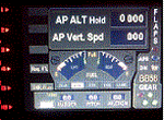
This gauge is for use in the Saitek FIP and has been developed specifically for the Baron 58 (FSX default) but also works fully with the E55. The gauge looks nothing like what you will find in the BB58 but I have incorporated the components that are found at the lower right side of the control yoke. It has been designed to complement the Saitek AP / Multi panel and to fit between the yoke and the multi panel.
The gauge is primarily to show the selected AP Altitude and Vert Spd whilst the AP / multi panel is displaying HDG. Placing it to the left of the AP / multi panel and at lower right side of the yoke puts all the elements of this gauge in roughly the position they would be found in a BB58. The 5 light indicators are just an addition I thought would be handy to have. The landing light indicator is right next to the
landing gear warning lights and acts as a reminder to have them on by the time the gear goes down.
| Filename: | Beachcraft_Baron_58_APAltVSFuel_Gauge_v1.zip |
| License: | Freeware |
| Added: | 6th July 2014, 14:12:53 |
| Downloads: | 191 |
| Author: | Robert Budd |
| Size: | 283.4 KB |
| Category: Flight Simulator 2004 - AFCAD Files | |
| Newark Liberty Int'l Airport (KEWR) with active Crosswind Runway |
|
Images related to this file:
File Description:
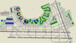
A high spec AFCAD2 for the FS2004 Newark Liberty Int'l Airport (KEWR) scenery by Steve Whalin. This afcad has been built using FAA Charts and information from the Airport Website. All taxiways are named and all aprons are reworked to be as real as possible according to photos. All gates are named as per real life and have airlines assigned to them. The Fedex and UPS aprons are represented and can accomodate many cargo aircraft. The final addition is random GA parking and the CO maintenance area to the north of the airport. Overflow parking is also available for rush hour periods (Ball Park). This airport features a tower view and also night and approach lighting. Finally, by using the crosswind runway technique, runways 04L/22R, 04R/22L and 11/29 can all be used simultaniously for take-off and landing. Runway 11/29 will be mainly used by CO Express flights. Enjoy!!
This afcad works with the Steve Whalin scenery only (Requires: kewr.zip).
| Filename: | Newark_Liberty_Intl_Airport_KEWR_with_active_Cross.zip |
| License: | Freeware |
| Added: | 2nd March 2010, 19:26:13 |
| Downloads: | 1,355 |
| Author: | Lee Brompton |
| Size: | 259.8 KB |
| Category: Flight Simulator 2004 - Miscellaneous Files | |
| ActiveSky Weather Adventures Vol. 2 - Fly the AT! |
|
File Description:
ActiveSky Weather Adventures Vol. 2 - Fly the AT! (Includes updated Vol. 1 - Winter's End) ***In addition to archives for AS2k4 users, saved flights with AS2k4 processed weather are included so people who don't own ActiveSky can fully enjoy these adventures and get a taste of what ActiveSky 2k4 has to offer! * Includes TWO Volumes of Weather Adventures * Volume 2 - Fly the AT! - Ten flights take you from Maine to Georgia along route of the Appalachian Trail - features three days of real-weather as a slow front approaches from the west - can YOU make it to Georgia before the thunder rolls in? * Volume 1 includes 10 flights highlighting weather phenomena such as a tornado outbreak in Texas and Oklahoma, a New England "nor'easter", and a massive upper-level low occupying the plains states! ***The ASWxAd-Kneeboard!*** A modification to FS9's kneeboard which allows viewing of original material describing these flights, radar and satellite loops, and annotated sectionals depicting flight plans and the AT! * This is the Automatic Installer version. A manual install is also available - ASAS2MAN.zip * Previous version had nearly 2000 downloads!
| Filename: | ActiveSky_Weather_Adventures_Vol_2__Fly_the_AT.zip |
| License: | Freeware, limited distribution |
| Added: | 4th June 2004, 14:14:58 |
| Downloads: | 2,798 |
| Author: | Scott Gridley |
| Size: | 22.04 MB |
| Category: Flight Simulator 2004 - Aircraft Repaints, Textures and Modifications | |
| Aeroflight BEECH U-21A-BH KING AIR |
|
File Description:
Aeroflight BEECH U-21A-BH KING AIR Based on the C90/C90A/C90B/E90
by Henry Tomkiewicz,Repaint and Window Modifications by- Dale Caruso
This package four configurations... a Medical Transport, Utility/cargo version, both with a 2-3 window configuration, a seperate crew/pilot entry located by the pilot's window, and a double air door for ease of patient and cargo access, a 3-3 window configuration, and a 3-4 standard window configuration, The package includes 2 separate visual models which can be used to create the following variations:
1) 3-Bladed props on PT6A-20 engines with a single fuselage ventral fin.
2) 4-Bladed props on PT6A-20 engines with a single fuselage ventral fin.
Also included to match up better with the flight model is a modified version of Randy Burton's King Air Panel. The modification being the addition of cabin views with windows that are more in the order of the U65-90 side window shape.
Questions or comments always welcome at [email protected]
Dale
| Filename: | Aeroflight_BEECH_U21ABH_KING_AIR.zip |
| License: | Freeware |
| Added: | 17th March 2005, 23:33:03 |
| Downloads: | 2,211 |
| Author: | by Henry Tomkiewicz,Repaint and Window Modifications by- Dale Caruso |
| Size: | 8.21 MB |
| Category: Flight Simulator X - Scenery | |
| Gold Coast Airport (YBCG) |
|
File Description:
The Gold Coast Airport (formerly known as Coolangatta) is a busy international airport located some 100 ks south of Brisbane and 850 ks north of Sydney. This scenery contains and accurate depiction of the terminal, control tower, hangers and the very distinctive lighthouse at Coolangatta (with beacon) plus night lighting of the apron. In addition many buildings have been added to Coolangatta and Surfers some of which are original but many are stock buildings. The scenery has been reduced in complexity to attempt to be reasonably frame rate friendly. All models are GMAX or FSDS3.0. Extensive coastline changes has added beaches as far south as Byron Bay and the canal network behind Surfers Paradise, Bond Uni, Currumbin and Coolangatta. Recent upgrades of the airport to a 2500 metre runway have been reflected as well as a widened apron. Therefore it may look a little different from the current Google Earth image but it is accurate. The airport will now handle direct flights from Asia and typical planes landing might include Airbus 343 or similar wide bodied aircraft.
| Filename: | Gold_Coast_Airport_YBCG.zip |
| License: | Freeware |
| Added: | 12th July 2007, 15:08:44 |
| Downloads: | 6,176 |
| Author: | John Ross |
| Size: | 12.16 MB |
| Category: Miscellaneous Files - General Utilities | |
| SimPicShot 1.5 |
|
File Description:
It makes storage of Screenshots and at the same time it's possible modify the picture before storing on the harddisk. It uses in addition routines of the popular Freeware program "IrfanView". The author has me permitted to pack its program in my ZIP file. It probably functions like that to nearly each well-known program "FSSCREEN". The most substantial differences are: picture numbers of 1-99999 + freely selectable Prefix, storage begins always after the largest number (gaps are not filled), a cutting off of the circulating edge possible (FS2004 1 pixel, FSX of 2 pixels), upper and lower edge can be removed (status bars), arbitrary scaling (with Resample), sharpnesses with selectable value, save in the JPEG format, not changed screenshot can be saved, place of the pictures freely selectable (new folder can be provided in the dialogue box), sound for key pressing, brightness and contrast changeable, cursor in Screenshot yes/no, black and white picture provide, multi-SHOT function with 2 variants, Tray Icon, display in the task bar (accessibility over ALT+TAB) yes/no
| Filename: | SimPicShot_15.zip |
| License: | Freeware, limited distribution |
| Added: | 18th January 2008, 23:50:51 |
| Downloads: | 2,382 |
| Author: | Gunnar Daehling |
| Size: | 1.63 MB |
| Category: Flight Simulator 2004 - Scenery | |
| CYYN Swift Current Municipal Airport |
|
File Description:
Swift Current Municipal airport is situated approximately 8 km east of the City of Swift Current. It is one of those tiny airports where the default flightsim scenery has no resemblance to the real world airport. CYYN was constructed using GMAX and represents the airport as it was in the Summer of 2007. It includes nearly all the buildings at the airport, runway signs, the addition of fencing, and a rotating beacon. CYYN also includes a landclass file to better represent the terrain around the airport, at least as far as the limits of the default landscape will allow. The airport has a long history, being built in 1937, as one of the hundred-mile airports on the Trans Canada airway. It was greatly expanded as an RCAF / RAF station during world war II. Many of the wartime structures still exist but many are in poor shape. Two of the original three runways remain in service. The airfield is often used by 15 Wing aircraft of CFB Moose Jaw to practice approaches.
| Filename: | CYYN_Swift_Current_Municipal_Airport.zip |
| License: | Freeware |
| Added: | 30th August 2008, 03:25:36 |
| Downloads: | 1,345 |
| Author: | Gregory Putz |
| Size: | 5.28 MB |
| Category: Flight Simulator 2004 - AI Aircraft | |
| Isles of Scilly Skybus de Havilland Canada DHC-6 Twin Otter |
|
File Description:
This is a repaint of the excellent de Havilland DHC-6 Twin Otter AI Model V.2 by Henry Tomkiewicz. Isles of Scilly Skybus is a British airline which operates seasonal and year round domestic scheduled services to the Isles of Scilly from various airports in south west England. The airline's main operating base is Land's End Airport (LEQ), whilst their head office is located in nearby Penzance, both in the county of Cornwall. The airline was established in March 1984 and started operations in August 1984. Isles of Scilly Skybus originated as an air charter operator at Land's End aerodrome which operated high frequency services to the Isles of Scilly. Following the withdrawal of Brymon Airways routes to and from the islands the operator stepped in, initially operating services to Plymouth. This route was later dropped but with the addition of Twin Otter aircraft the route network expanded to its current make-up. It is wholly owned by Isles of Scilly Steamship Company who also run the passenger ferry, Scillonian III, and freight services from Penzance to the Islands.
| Filename: | Isles_of_Scilly_Skybus_de_Havilland_Canada_DHC6_Tw.zip |
| License: | Freeware |
| Added: | 13th October 2008, 14:52:24 |
| Downloads: | 584 |
| Author: | John O'Leary |
| Size: | 676.07 KB |


© 2001-2026 AVSIM Online
All Rights Reserved
Privacy Policy |