
Where Flight Simulation Enthusiasts Gather from Around the World!
AVSIM Library - Search Results

| Category: Flight Simulator 2004 - Scenery | |
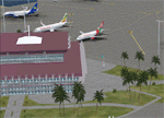
| KCLT Charlotte Douglas International Airport |

|
Images related to this file:
File Description:
In 2008 runway 18R/36L at KCLT was renamed 18C/36C in anticipation of a third parallel under construction. The new runway was to be designated 18R/36L and was finally activated on January 6, 2010. This scenery adds that new runway to the default Charlotte Douglas International Airport (KCLT). This is a complete rebuild of my previous upload, KCLT2010 (not required) that inadvertently removed approximately 30 airports in the Charlotte area, including Fayetteville and Spartanburg. It also includes Terminal E, which was added in 2002, but never made it into the default FS2004 scenery.
I used Airport Design Editor (ADE9x) to modify the default FS2004 KCLT file, renaming the default 18R/36L to 18C/36C, create the new taxiways, taxi signs, NavAids, 18R-36L runway, and Terminal E. I used Abacus EZ-Scenery to add jetways, gate markings, and ramp lights. All files, libraries, and textures are either default or included. No additional downloads are required. AI Aircraft were acting normally on my system. I sat at Taxiway W2 for the new Runway 18R/36L and watched AI Aircraft land and take off from it after creating this scenery.
| Filename: | KCLT_Charlotte_Douglas_International_Airport.zip |
| License: | Freeware, limited distribution |
| Added: | 12th January 2011, 22:34:51 |
| Downloads: | 3,560 |
| Author: | Randy Tyndall |
| Size: | 1022.34 KB |
| Category: Flight Simulator X - Scenery | |
| 2016 Kigali Intl (HRYR) Rwanda |
|
Images related to this file:
File Description:
This sequel to the 2009 Kigali Intl (HRYR) Rwanda scenery (by Jacques Botha and Frits Beyer) brings it up to date with the current layout and enables full compliance with FTX Global/Vector and FSX. Buildings are added and adjusted to their real-world locations, and the new taxiway and south apron are added according to the May 2016 satellite imagery. In addition to real-world gate locations, custom apron markings are added along with apron lighting. The landclass around Kigali is also updated, and SRTMGL1 (30m) mesh is included. This scenery can be complemented by the Goma (FZNA) and Gisenyi (HRYG) scenery (FSX_FZNA-HRYG_CS.zip), and GA flightplans are included to supplement the commercial traffic at Kigali and provide more activity at FZNA and HRYG.
Updates were created or rebuilt in a manner which carefully aligns airport data with current satellite imagery. Scenery was created using Airport Design Editor X v1.70.6042, SBuilderX 3.13, and the FSX Object Placement Tool. Scenery objects were added and modified from stock FSX scenery to resemble as closely as possible the actual airports. The FSX apron lights included are from the set created by Jim Dhaenens.
| Filename: | 2016_Kigali_Intl_HRYR_Rwanda.zip |
| License: | Freeware |
| Added: | 4th August 2016, 21:10:09 |
| Downloads: | 3,381 |
| Author: | Carlyle Sharpe, Jacques Botha, and Frits Beyer |
| Size: | 17.12 MB |
| Category: Flight Simulator X - Aircraft Repaints, Textures and Modifications | |
| Airbus A318 FD Special Version V2 |
|
Images related to this file:
File Description:
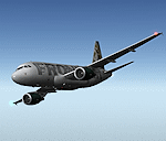
After my initial work on the Project airbus A318 (V1.2) and on the project Airbus A319 (A319 Special Version V2), I present my special version of the Project Airbus A318 Version 2, which includes many improvements and new features.
The instrument panel has been adapted of the Stefan Liebe work, on which I have added many changes. I created a vertical navigation gauge (VNAV gauge) which manages automatically the climb of the aircraft like a FMC (it can be work in several stage), with pre-programmed data according the weight of the aircraft and the altitude. The autopilot is constant MACH, with a transition altitude of 25000ft, thus avoiding the risk of overspeed. The ND will display information page in real time on the flight plan, an information page on the destination airport and display the radar map of the terrain, with AI traffic in real time.
All instruments are active in the VC and 2D panel. The instruments were completed by a multitude of small details. I have improved the autolanding function, with a soft landing (rounded). There is a complete operating manual in PDF format, in English and in French. Of course, TOGA mode and Autobrake mode works. Only compatible with FSX SP2 or Acceleration. See the readme file and the user manual for information and copyright. This version is also a big upgrade on the A318 special version 1.0 and 1.2. This is not an update, but a new aircraft. Francois Dore.
| Filename: | Airbus_A318_FD_Special_Version_V2.zip |
| License: | Freeware, limited distribution |
| Added: | 6th April 2012, 19:59:27 |
| Downloads: | 11,990 |
| Author: | Francois Dore, Project Airbus, Stefan Liebe |
| Size: | 134.71 MB |
| Category: Flight Simulator X - Scenery | |
| KAFW Fort Worth Alliance Airport - Texas, US |
|
Images related to this file:
File Description:
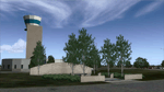
Ft. Worth Alliance Airport opened in 1989 and was billed as the world's first purely industrial airport. It is located around 14 miles North of the central business district of Ft. Worth and is also nearby the Dallas/Ft. Worth International Airport (KDFW). The airport serves general aviation, corporate jet, cargo, and military air traffic on a daily basis and it's proximity to the Texas Motor Speedway (only a few miles) brings extra dense traffic on race weekends. The airport is home to the American Airlines 777 and 767 maintenance base, FedEx Southwest Regional Sort Hub, Bell-Helicopter Training Center, DEA Air Operations Center and DynCorp International. Sadly the American Airlines maintenance base is set to close at the end of 2012 but is being kept alive in FSX!
This scenery features custom 3d buildings and objects bringing you a very accurate rendition of Ft. Worth Alliance Airport. Requires FSX Acceleration for the all scenery objects to display correctly.
Note: These files MUST be installed for the scenery to work correctly (otherwise there will be missing scenery objects at the airport):
-Filename: fsx_lts.zip - Ramp Lighting for FSX by Jim Dhaenens
-Filename: dlfcorelibraries2fsx.zip - Dan French Core Library Vol. 2
-Filename: lightstoo.zip - Jim Dhaenens Airfield Lighting
-Filename: objlib-jgse-fsx.zip - John Stinstrom JGSE Yellow Objects - this newer file replaces the older FS9 libraries with FSX versions
-Filename: objlib-ggse-fsx.zip - John Stinstrom GGSE Green Objects - this file also replaces FS9 libraries with FSX versions
| Filename: | KAFW_Fort_Worth_Alliance_Airport__Texas_US.zip |
| License: | Freeware, limited distribution |
| Added: | 12th December 2012, 16:56:36 |
| Downloads: | 2,932 |
| Author: | Brandon Thetford |
| Size: | 439.24 MB |
| Category: Flight Simulator X - Aircraft Repaints, Textures and Modifications | |
| Nord Noratlas Israeli Air Force (4X-FAP) |
|
Images related to this file:
File Description:

This folder contains a repaint for the Nord 2501 Noratlas by Projet Noratlas in the colors of N2501IS 4X-FAP, the first of the Noratlas aircraft used by the Israeli Air Force. In the immediate post-war era France produced a plethora of prototype aircraft, nearly all of which vanished without trace. One of those that made good was the Nord 2500, a cargo transport with the same twin-boom configuration as the American C-119, with the cockpit in the nose of a capacious nacelle. Like the US type, the rear doors were of the left/right clamshell type, so for air-dropping heavy loads they had to be removed before takeoff, causing turbulence and high drag. Despite this, the more powerful 2501 proved an excellent aircraft, produced in large numbers in France and Germany in a programme that led directly to the Transall, produced by the same partners, designed in 1959 and flown in 1962.
Israel bought eight N.2501 IS direct from Nord in 1955-59, a further 12 from Germany in 1962, and four more later. The first, 4X-FAP, was delivered before the end of 1955, and immediately proved extremely popular and capable.
Eight Nords had been purchased and these were used extensively to re-supply IDF columns in Sinai. To assist with these re-supply efforts other Nords were made available from the French Air Force and were requisitioned from Israeli Airline EL-AL which used them as freight transports. Repaint by Jan Kees Blom, based on the paintkit by Projet Noratlas.
| Filename: | Nord_Noratlas_Israeli_Air_Force_4XFAP.zip |
| License: | Freeware |
| Added: | 23rd July 2020, 17:39:27 |
| Downloads: | 145 |
| Author: | Jan Kees Blom |
| Size: | 11.6 MB |
| Category: Miscellaneous Files - Demos from Commercial Vendors | |
| QuickPlan for Windows |
|
Images related to this file:
File Description:

QuickPlan for Windows is a visual point and click flight planner that makes it easy to generate flight plans in native FSX, FS2004 or X-Plane formats.
The entire route is generated visually, by tapping the map to add the departure airport, intermediate waypoints and arrival airport in the same order that you intend flying the plan.
During plan creation and after adding the final arrival waypoint you also have the opportunity to remove any of the intermediate waypoints before saving the plan in your preferred format.
QuickPlan utilises a new mapping engine and includes 12 world-wide map styles and has support for FSWidgets Cloud Based Aero Charts (free Cuba/Puerto Rico WAC Cloud Based Chart included) and FSWidgets Cloud Based World Nav Data (Free KSFO - San Francisco Bay area Nav Data included).
QuickPlan can be used in Freeform Mode, Advanced Mode, or a combination of both.
FREEFORM MODE: Simply click anywhere on the map and QuickPlan will allow you to add it as a generic waypoint. VFR pilots often use towns, lakes and other unique geographic features and with QuickPlan you can add any geographical location shown on the base map. Plans created this way label the waypoints automatically with generic names (e.g. DEP, WP1, WP2, ARR).
If desired, the entire route from departure to arrival can be created without reference to any navigational aids or official airports. This is handy for bush pilots who often use unlicensed airfields and small landing strips (or seaplane landing areas). Helicopter pilots can also quickly create plans that depart from off-airport locations like building rooftops or land on a road.
ADVANCED MODE: If you own the FSWidgets Cloud Based World Nav Data product you can create more advanced flight plans by clicking on any of the icons displayed on the map to add them as waypoints - airports, VOR's, NDB's and intersections (data for the KSFO area is included free). Plans created this way label the waypoints automatically with airport and navigational aid identifiers taken from the Nav Data (e.g. KSFO, OSI, LV, FABLA). FEATURE LIST:
- Generates native FSX (.pln), FS2004 (.pln) and X-Plane (.fms) format flight plans
- Saves flight plans to any folder (preferred folder set in Preferences)
- Search for airport by ICAO identifier
- Map powered by CloudMade Leaflet API (using OpenStreetMap data)
- Includes 12 world-wide maps styles
- Supports FSWidgets Cloud Based AERO CHARTS
- Free Cuba/Puerto Rico WAC Cloud Based Chart included
- Supports FSWidgets Cloud Based WORLD NAV DATA
- Free KSFO (San Francisco Bay) area Nav Data included
- World-wide Metar and TAF Data icons
- US Nexrad (Next-Gen Radar) Data
| Filename: | QuickPlan_for_Windows.zip |
| License: | Commercial demo |
| Added: | 27th October 2012, 09:22:33 |
| Downloads: | 523 |
| Author: | Fermin Fernandez - FSWidgets |
| Size: | 1.95 MB |
| Category: Prepar3D V1-4 - AI Flight Plans | |
| Nomads Travel Club 1998 |
|
File Description:
Nomads Travel Club may be one of the most storied travel clubs in aviation history. Founded in 1961 and based in Detroit(DTW), where the airline had it's own terminal, Nomads Travel Club gave up to 10,000 adventurous members the opportunity to hop on aircraft for elaborate tours across the earth. Initially flying a DC-7C, the airline upgraded to a L-188 Electra, CV-990, 727-100, and finally 727-200 N727M in 1993 which served the club until it's demise in 2011. N727M has traveled to dozens of countries and hundreds of airports, and I was able to find good information about 2 tours flown in 1998 and represented them in these plans. The aircraft spends at least half a day at each destination except for YHZ which is just a Westbound refueling stop. As far as I could find, the airline had no callsign or codes, so I am guessing they used the registration as a callsign. There is a paint for the AIA 727-200 on Avsim as "aib722nomads.zip".Flightplans by Chasen Richardson, based on real tours flown in 1998. Part of the 1998 Flight Simulator Project. Follow us on Facebook at facebook.com/flightsim98 and on instagram as @bayviationsim. For more Retro AI, check out the forums at: http://retroai.proboards.com/
| Filename: | Nomads_Travel_Club_1998.zip |
| License: | Freeware, limited distribution |
| Added: | 2nd December 2019, 14:26:43 |
| Downloads: | 60 |
| Author: | Chasen Richardson\Bayviation |
| Size: | 747.92 KB |
| Category: Dovetail Games Flight Sim World - Scenery | |
| UUEE MOSCOW SHEREMETYEVO X DEMO |
|
Images related to this file:
File Description:

UUEE MOSCOW SHEREMETYEVO X DEMO is a scenery of UUEE Sheremetyevo airport in Moscow, Russia, fully compatible with FSX/FSX:SE/P3Dv1/P3Dv2/P3Dv3/P3Dv4 and FSW by Dovetail.
This product is a fully functional DEMO version of the commercial payware product. Most objects are modelled as in the full version but covered with low resolution textures. Using this free demo ensures no problems with online (VATSIM, IVAO, multiplayer etc.) flying in case some users use the payware scenery and some don't.
Moscow is the capital city and the most populous federal subject of Russia. The city is a major political, economic, cultural and scientific center in Russia and in Eastern Europe. Sheremetyevo International Airport (SVO/UUEE) is an international airport located in Khimki, Moscow Oblast. It is a hub for passenger operations of the Russian international airline Aeroflot, and is one of the three major airports that serve Moscow, along with Domodedovo International Airport and Vnukovo International Airport
The product is equipped with an automatic installer, which means that the scenery will be automatically added to the Flight Simulator Scenery Library. Please uninstall all previous versions of this airport you may have installed before. Please make also sure that no duplicated AFCAD files are installed.
Enjoy your virtual flying with Drzewiecki Design!
| Filename: | UUEE_MOSCOW_SHEREMETYEVO_X_DEMO.zip |
| License: | Freeware, limited distribution |
| Added: | 13th May 2018, 02:23:50 |
| Downloads: | 79 |
| Author: | Drzewiecki Design |
| Size: | 19.41 MB |
| Category: Dovetail Games Flight Sim World - Scenery | |
| UUEE MOSCOW SHEREMETYEVO X DEMO |
|
Images related to this file:
File Description:
UUEE MOSCOW SHEREMETYEVO X DEMO is a scenery of UUEE Sheremetyevo airport in Moscow, Russia, fully compatible with FSX/FSX:SE/P3Dv1/P3Dv2/P3Dv3/P3Dv4 and FSW by Dovetail.
This product is a fully functional DEMO version of the commercial payware product. Most objects are modelled as in the full version but covered with low resolution textures. Using this free demo ensures no problems with online (VATSIM, IVAO, multiplayer etc.) flying in case some users use the payware scenery and some don't.
Moscow is the capital city and the most populous federal subject of Russia. The city is a major political, economic, cultural and scientific center in Russia and in Eastern Europe. Sheremetyevo International Airport (SVO/UUEE) is an international airport located in Khimki, Moscow Oblast. It is a hub for passenger operations of the Russian international airline Aeroflot, and is one of the three major airports that serve Moscow, along with Domodedovo International Airport and Vnukovo International Airport
The product is equipped with an automatic installer, which means that the scenery will be automatically added to the Flight Simulator Scenery Library. Please uninstall all previous versions of this airport you may have installed before. Please make also sure that no duplicated AFCAD files are installed.
Enjoy your virtual flying with Drzewiecki Design!
| Filename: | UUEE_MOSCOW_SHEREMETYEVO_X_DEMO.zip |
| License: | Freeware, limited distribution |
| Added: | 23rd August 2017, 01:40:38 |
| Downloads: | 47 |
| Author: | Drzewiecki Design |
| Size: | 20.67 MB |
| Category: X-Plane - Scenery | |
| BR ES SBVT - Goiabeiras Vitoria v1.0.0 |
|
Images related to this file:
File Description:

This is an X-Plane 11 and X-Plane 10 scenery package for Eurico de Aguiar Salles Airport (IATA: VIX, ICAO: SBVT), formerly called Goiabeiras Airport after the neighborhood where it is located, which is the airport serving Vitoria metro area, in Brazil. It includes corrected aprons, ramps, gates, taxiways, lighting system, renovation work construction of new runway and new terminal building, the city skyline buildings and (XP11 only) airport ground services (like push back). Located 10 km (6 mi) from downtown Vitória, the airport handles domestic flights only, and has the capacity to receive medium-sized aircraft such as the Boeing 737 and the Airbus 320. It is considered one of the worst among the main airports in Brazil due to lack of renovations. Delayed renovation works have started at the airport, with the construction of a second runway, and a brand new terminal building. This scenery was tested and is operational (as of February 25, 2017) in "X-Plane 11 Public Beta #12 64 bit", Windows 10 Home. It was also tested and is also operational (as of February 25, 2017) in "X-Plane 10.51 64 bit", Windows 10 Home. Only the default X-Plane 11 libraries, by Laminar Research, are needed. No third party libraries are used.
| Filename: | BR_ES_SBVT__Goiabeiras_Vitoria_v100.zip |
| License: | Freeware |
| Added: | 26th February 2017, 08:06:44 |
| Downloads: | 113 |
| Author: | Rui Mesquita |
| Size: | 9.58 MB |
© 2001-2026 AVSIM Online
All Rights Reserved
Privacy Policy |