
Where Flight Simulation Enthusiasts Gather from Around the World!
AVSIM Library - Search Results

| Category: Flight Simulator X - Scenery | |
| Neujellingsdorf/Fehmarn, Germany ** Version 1.2 ** |

|
Images related to this file:
File Description:
This Version is only a small update wich makes the scenery a bit more realistic.
This small private Airstrip is situated on the island of Fehmarn in nothern Germany. It does not exist in the standard FSX. Because this strip does'nt have an ICAO-code I created one: ED01. Under this code you can find the airstrip in the FSX airport list.
I addited a photo-based background featuring all four seasons, although this airstrip is closed during the winter in real life.
During the summerseason it is mainly used for sightseeing trips over Fehmarn with a C172 offered by the one-aircraft-company "Fehmarn Air" (http://www.fehmarn-air.de/).
Libraries needed to install first if not already installed:
http://library.avsim.net/download.php?DLID=192454
B: FlightPort Dynamic Library_FSX for a lot of other objects
http://www.flightport.de/libraries/flightport-library/
C: FS_Piloten_Objektlibary
http://www.fs-piloten.de/thread.php?threadid=1063&sid=d07a13eb9fcb4469700df5c3de1fd6c1
| Filename: | NeujellingsdorfFehmarn_Germany__Version_12_.zip |
| License: | Freeware |
| Added: | 16th July 2016, 18:01:47 |
| Downloads: | 784 |
| Author: | Wolfgang Allers |
| Size: | 27.05 MB |
| Category: Flight Simulator 2004 - Scenery | |
| Kona at Keahole International Airport PHKO |
|
File Description:
This is a completely new Kona, which is now more correctly laid out and very detailed. This is one of the most unique and beautiful airports in the world. It resembles a Hawaiian Village and Botanic garden combined, and is completey open air. The airport is built on old lava flows, and the terminal area is full of lava rock walls, which was probably mined while constructing the taxiways, tarmacs, and terminal itself. This scenery redoes the entire airport, and includes details like baggage carrousels, benches at the gate areas, check-in counters, parking lot shelters, and some purple baggage carts to go with the Island atmosphere. Since this airport has no jetways, I have created some new lower impact air stairs, and have positioned them around the two main gate areas. There is also a large air stair at each gate area to accommodate heavy jetliners. The unique ramp lights found at this airport are also included as well as some interesting night lit ramp textures. It has not been tested in FS2002.
| Filename: | Kona_at_Keahole_International_Airport______PHKO.zip |
| License: | Freeware |
| Added: | 16th January 2004, 14:14:35 |
| Downloads: | 6,781 |
| Author: | Bill Melichar |
| Size: | 5.52 MB |
| Category: Flight Simulator 2004 - AFCAD Files | |
| T.F. Green State Airport - Providence (PVD/KPVD) |
|
File Description:
AFCAD of the KPVD airport. Includes accuarate gate numbering and locations for all airlines serving the airport as well as assigned cargo areas and parking for general aviation aircraft. This is my continuing series of doing airports that have been neglected by both MS and the community. Hopefully this will enhance flying into this airport for those of you that frequent it. Terminal space for this airport is actually slightly better then previous airports I've done but still a bit on the small side, I've had to expand the ramp space from the default since it was shaped wrong. Every gate, however, is present and correctly numbered and airlines assigned to the right gates based on the PVD airport website. Delta, US Airways and Southwest seem to be the dominant carriers to this airport. I will be continuing to do mid sized aiports accross the US and then probably do some updates to my original Central America and Caribbean afcads. Hope this enhances your flying into and out of the beautiful state of Rhode Island.
| Filename: | TF_Green_State_Airport__Providence_PVDKPVD.zip |
| License: | Freeware |
| Added: | 2nd July 2004, 21:09:44 |
| Downloads: | 1,089 |
| Author: | Jason Diaz |
| Size: | 127.73 KB |
| Category: Flight Simulator 2004 - Sounds | |
| ATC Voices -Airport Names Set 8 |
|
File Description:
A collection of 28 additional and corrected airport names, for use with Flight Simulator 2004 and FS2002. Installation requires the EditVoicepack software by Lars Møllebjerg which is also available free download from the usual Flight Simulator download sites such as Avsim.
The airports represented here are:
64I: Lee Bottom (United States of America),
IWK: Wales (United States of America),
KCMX: Houghton Co Meml (United States of America),
KERR: Errol (United States of America),
KMPV: Knapp State (United States of America),
KMVL: Morrisville Stowe State (United States of America),
KSCX: Scott Municipal (United States of America),
KSHL: Sheldon Mun (United States of America),
KSIK: Sikeston Meml Mun (United States of America),
LDDP: Ploce (Croatia),
LDPV: Vrsar (Croatia),
LFLX: Deols/Chateauroux (France) - fix,
LIPV: Venice San Nicolo (Italy),
LSME: Emmen (Switzerland),
MDCR: Cabo Rojo (Dominican Republic),
OIBJ: Jam/Tohid (Iran),
OIBV: Lavan (Iran),
OISR: Lamerd (Iran),
RJSK: Akita (Japan),
RJSR: Odate-Noshiro (Japan),
UHPT: Tilichiki (Russian Federation),
ULAM: Naryan-Mar (Russian Federation),
VEJH: Jharsuguda (India),
WI72: Ellenboro (United States of America),
YAYR: Ayr (Australia),
YJAP: Jabiru (Australia),
YPAM: Palm Island (Australia), and
YWDH: Windorah (Australia).
| Filename: | ATC_Voices_Airport_Names_Set_8.zip |
| License: | Freeware |
| Added: | 8th July 2007, 20:55:00 |
| Downloads: | 2,007 |
| Author: | John Hinson |
| Size: | 20.92 KB |
| Category: Flight Simulator 2004 - Aircraft Repaints, Textures and Modifications | |
| Air Jordan de Havilland DH-89a Rapide |
|
File Description:
Aircraft history - c/n 6687 was built at Loughborough as a DH89B Dominie and had the RAF serial number NR811. Postwar, she was converted to a DH89A and became Channel Island Airways’ G-AGSK 27th Oct 1945, then went to Jordan in October 1953 as Air Jordan’s TJ-ABP. Some time between 1953 and 1956 the Jordanian registration letters changed from TJ- (TransJordan?) the JY-, and she became JY-ABP (TJ- is now Caneroons). I don’t know how long she survived after 56, but there’s a reference on the web to a photo of her wreckage.
Airline history: Air Jordan was founded in 1950 by H E Ismail Bilbesi and was partly owned by Trans Ocean Airways. They initially flew Airspeed Consuls on domestic routes out of Amman, but later acquired some C-47s from Trans Ocean to fly the Amman – Kuwait – Kandahar – Kabul route (could be a DC-3 Airways charter there!). In 1960, they acquired a DC-6, and they went bust in ’61. There routes were taken over by Jordan Airways (aka Jordanian).
| Filename: | Air_Jordan_de_Havilland_DH89a_Rapide.zip |
| License: | Freeware |
| Added: | 7th June 2005, 02:07:31 |
| Downloads: | 519 |
| Author: | Tim Trivett |
| Size: | 2.52 MB |
| Category: Flight Simulator X - Aircraft Repaints, Textures and Modifications | |
| P-51D Swedish Air Force 26152 |
|
File Description:
This folder contains a repaint for the Shockwave World War II Fighters P-51D Mustang. Repaint by Jan Kees Blom, based on the repaint kit by John Terrell. It is for FSX only, as it contains 2048 x 2048 textures. For FS9, look for my earlier "Sierra Sue II" repaint, which contains a low res version of this repaint.
This aircract represents a J-26 of the Royal Swedish Air Force. A/C 26152 was previously 44-63675 E6-D "Sierra Sue II" of the 402nd FS, USAAF, flown by Lt. Bob Bohna. She was sold to Sweden after the war and flew with with 3rd squadron of the F4 wing, based on the island of Froson, with Cpl Sten Soderquist as her regular pilot. In 1954, she was sold to Nicaragua were she flew with registration GN91. She came to the US in 1970 and is currently owned by Roger Christgau, who flies her as "Sierra Sue II / Gul Kalle". Repaint by Jan Kees Blom, based on the repaint kit by John Terrell.
| Filename: | P51D_Swedish_Air_Force_26152.zip |
| License: | Freeware |
| Added: | 25th December 2008, 20:11:58 |
| Downloads: | 200 |
| Author: | Jan Kees Blom |
| Size: | 24.3 MB |
| Category: Flight Simulator 2004 - Scenery | |
| LGSR - Santorini Big Scenery - Santorini, Greece ** TEXTURE UPDATE ** |
|
Images related to this file:
File Description:
This FS2004 package is a free texture update for our previous greek "Santorini big scenery". The original project contain the "Santorini Thira Int. Airport" (Iata: JTR - Icao: LGSR)scenery and the "Santorini island" scenery (lanclasses, landmarks, autogen and more).
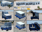
With this texture update (over 50 new files) you'll become new textures for some ground service veihcles (better quality and updated fuel companies), new textures for some airport buildings (updated to summer 2015, better resolution and quality), new "soft edge transition" on the apron textures, reduced texture size for the far away scenery objects (the result is a frame rate improvement) and other minor texture updates. This package contains textures only so the original "Santorini big scenery 2012" demo/free or full version is required.
Watch the screenshot and the demo video on the Albysim youtube chanel and check all scenery features reserved to the Premiun User (3D papi lights, 3D taxi lights, new vehicles, new autogen greek houses, new volumetric grass, new cablecar, other new details and objects).
| Filename: | LGSR__Santorini_Big_Scenery___Santorini_Greece___T.zip |
| License: | Freeware |
| Added: | 30th September 2015, 17:29:55 |
| Downloads: | 1,227 |
| Author: | Albysim Scenery Design |
| Size: | 17.63 MB |
| Category: Prepar3D V1-4 - Scenery | |
| Piarco International Airport - TTPP V1.2 |
|
File Description:
TTPP v1.2 - In this version, problems with markings in tax lanes have been fixed. The textures of the taxi stands have also been redone. More vehicles and vegetation were included.
Piarco International Airport (IATA: POS, ICAO: TTPP) is an international airport serving the island of Trinidad and is one of two international airports in Trinidad and Tobago. The airport is located 30 km (19 mi) east of Downtown Port of Spain, located in the adjacent town of Piarco. It is the seventh busiest airport in the Caribbean in terms of passengers served[6] and third busiest in the English-speaking Caribbean, after Sangster International Airport and Lynden Pindling International Airport. The airport is also the primary hub and operating base for the country's national airline, as well as the Caribbean's largest airline, Caribbean Airlines.
Piarco International Airport has direct scheduled service to destinations in the United States, Canada, Central America, South America and Europe. It is also a significant transit hub for the Southern Caribbean and serves as the primary connection point for many passengers travelling from Guyana.
| Filename: | Piarco_International_Airport__TTPP_V12.zip |
| License: | Freeware |
| Added: | 4th February 2022, 03:49:10 |
| Downloads: | 562 |
| Author: | Eduardo Puelker |
| Size: | 53.65 MB |
| Category: Flight Simulator 2004 - Scenery | |
| PASY - Shemya (Eareckson Air Station) - Alaska, USA |
|
Images related to this file:
File Description:
Shemya is pretty well AT the western end of the Aleutian chain of islands in Alaska, around 240 miles west of Amchitka. There is no town on Shemya and the whole island is occupied (and owned) by the Air Force. There are three runways, two of which are from the 1940's and are now unused; in fact one of them has been partly ploughed up and also used for outdoor storage. The single in-use runway is aligned 10-28 and is 10,000 feet of 150 feet wide asphalt with an ils on 28, the runway that is used 99% of the time. The base is now not active but is maintained as a refuelling facility, so for landing and takeoff purposes it is open. The older and now unused areas are those where the hangers are slowly rusting away and the asphalt is turning green with encroaching and well-watered wildlife plants. The tower is now closed, so there is no atc and you just announce your intentions. Read the history of Shemya, a lot happened there.
| Filename: | PASY__Shemya_Eareckson_Air_Station__Alaska_USA.zip |
| License: | Freeware, limited distribution |
| Added: | 18th February 2015, 19:52:36 |
| Downloads: | 453 |
| Author: | Roger Wensley |
| Size: | 8.81 MB |
| Category: Flight Simulator 2004 - Scenery | |
| Little Port Walter for Holger Sandmann's Tongass Fjords scenery |
|
Images related to this file:
File Description:
This is a second fish farm at the southern end of Baranof Island and Chatham Strait in southern Alaska. Big Port Walter is named on the chart of the area, and there is a section of the chart included here. Little Port Walter is a much smaller offshoot bay, sheltered from the weather and ideal for a fish farm. This scenery is designed specifically for use in the Tongass Fjord scenery. I may have incorrectly identified Tongass Fjords as being required for Hawk Logging when Glacier Bay is needed. Ah well, it is one or the other of them. The fish farm (or hatchery, the description varies) has an identifying code so it will show up on a gps as PWL. There is no interaction with atc as there are no designated water runways, so PWL on the gps just acts as a waypoint. There will be further posts for use with Tongass Fjords, Misty Fjords, and Glacier Bay, and I still find these scenery areas by Holger and his crew the most satisfying in FS9.
| Filename: | Little_Port_Walter_for_Holger_Sandmanns_Tongass_Fj.zip |
| License: | Freeware, limited distribution |
| Added: | 23rd November 2014, 01:33:12 |
| Downloads: | 234 |
| Author: | Roger Wensley |
| Size: | 3.38 MB |


© 2001-2026 AVSIM Online
All Rights Reserved
Privacy Policy |