
Where Flight Simulation Enthusiasts Gather from Around the World!
AVSIM Library - Search Results

| Category: Flight Simulator 2004 - Scenery | |
| Ría de Vigo (Bay of Vigo) |

|
File Description:
Comprehensive revision of the area surroinding the Bay of Vigo, near the Vigo Airport (LEVX, aprox. at 42º18'N 8º38'W), in Galicia, Spain, including a more accurate coastline, from the Ría de Aldán until Toralla Island, plus the San Simon Island and other minor islands, detailed piers in Vigo and Cangas, several beaches, and a lot of 3D VFR references (more than 180 macros added), such as buildings (the City Hall, the Hospital Xeral, the Balaídos Stadium, the Castro stronghold...), working lighthouses, several monuments and statues, some main streets redrawn, a new version of my Rande Bridge, now with collision detection and landable surface, and a handfull of eye-candies I can't even remember! -
Completa revisión da costa da Ría de Vigo, dende a Ría de Aldán ata pasada a Illa de Toralla, incluíndo, por suposto, á Illa de San Simón e outros pequenos illotes, praias (Samil, Nerga...), os peiraos de Cangas e de Vigo, dende o Areal ata Bouzas, unha morea de novas referencias visuais (máis de 180 macros), con edificios (o Concello, o Hospital Xeral, o estadio de Balaídos, o castelo do Castro, o lazareto de San Simón...), faros (nas Cíes e na costa...), algún que outro monumento, unha revisión do trazado dalgunhas das vías principais, unha nova versión da miña Ponte de Rande, con detección de colisións e superficie "aterrable", e moitas cousas máis que xa nin eu mesmo lembro. -
Completa revisión de la costa de la Ría de Vigo (Galicia, España, aprox. en 42º18'N 8º38'O), desde la Ría de Aldán hasta pasada la Isla de Toralla, incluyendo la Isla de San Simón y otros pequeños islotes, playas (Samil, Nerga...), los muelles de Cangas y de Vigo, desde el Areal hasta Bouzas, un montón de nuevas referencias visuales (más de 180 macros), con edificios (el Ayuntamiento, el Hospital Xeral, el estadio de Balaídos, el castillo del Castro, el lazareto de San Simón...), faros (en las Cíes y en la costa...), algún que otro monumento, una revisión del trazado de algunas de las vías principales, una nueva versión de mi Puente de Rande, con detección de colisiones y superficie "aterrizable", y muchas cosas más de las que ni yo mismo me acuerdo.
| Filename: | Ra_de_Vigo_Bay_of_Vigo.zip |
| License: | Freeware |
| Added: | 16th May 2004, 23:48:38 |
| Downloads: | 4,478 |
| Author: | Rubén Castiñeiras |
| Size: | 366.85 KB |
| Category: Flight Simulator 2004 - Scenery | |
| Victoria, Canada area scenery |
|
File Description:
This is a complete upgrade of vicenh05, Victoria, Canada area scenery for FS9. New in this version: automated installer and configurator from Ken Peters; several detailed models including the Empress Hotel, the Legislature, the Regent Hotel and the Johnson St. Bridge; greatly enhanced Inner Harbour; many generic buildings representing buildings throughout the area; 7 new small airfields with sloping runways; seven new floatplane bases (owners of Vancouver+ get extensive floatplane traffic in local liveries); 7 new heliports (Vancouver+ users get additional heli AI traffic) and a myriad of minor fixes and improvements. Included from previous versions are revised shorelines, landclass and 19m mesh and buffer meshes for South-Eastern Vancouver Island; boat docks with static boats, seaplane docks and terminal buildings for Harbour Air, Kenmore Air and West Coast Air; piers, buildings, breakwater and other components of the Ogden Point Terminal; dock, service building and pilot boats of the Pacific Pilotage Authority; Odgen Point Cafe and Dive Shop; marine navigational lights for Victoria Harbour and area, including Esquimalt harbour and Oak Bay; antennae location corrections for the area; AFCADs included: Land based (CML2), Floatplane (CAB3, CAP5, CAP8, CAV8, CAW7, CAX6, CMAP, CYWH), Heli (CAL7, CBF5, CBF7, CBK8, CBW7, CBW9, CBZ7, CMBH); AI craft models and repaints (Cruise ships are repaints of Asuka model by Mitsuya Hamaguchi: MS Amsterdam of the Holland America Line travelling from Victoria to Vancouver, MS Summit of the Celebrity Cruise Line travelling from Seattle to Victoria); S-61 Sea-King helicopter in Helijet colours; Pacific Pilot custom vessel working from the Pilot dock; 22, 30 and 40 foot vessels plying the harbour and nearby Straight of Juan de Fuca. Effects included for lights, water, smoke effects. Many flights are offered, including two flights for owners of the Aerosoft Beaver (not required). Ultimate Terrain compatible (not required). Users of Misty Fjords will also get additional cruise ship traffic: the Island Princess and the Volendam alternating with the Amsterdam and Summit. Fully compatible with Don Grovestine's excellent CYYJ 2007. Replaces viflat.zip, ve4_tr1.zip, vicenh02.zip, vicenh03.zip, vicenh04.zip and vicenh05.zip. Detailed documentation included. By Jon Patch and Holger Sandmann.
| Filename: | Victoria_Canada_area_scenery.zip |
| License: | Check within download |
| Added: | 29th January 2010, 21:22:09 |
| Downloads: | 5,318 |
| Author: | Jon Patch and Holger Sandmann |
| Size: | 24.28 MB |
| Category: Prepar3D V1-4 - AI Flight Plans | |
| Aloha Air 1998 AI Flightplans |
|
File Description:
By 1998, Aloha Air was down to operating 737-200s, having ditched the 737-300s and 737-400s that they flew earlier in the 1990s. The 737-200 would remain the mainstay of the inter-island fleet until the shutdown in 2007. Impressively, every one of the airlines' high frequency routes was daily. The arrival of the 737-700s and flying to the mainland USA would come a little later. The airline would eventually fail in 2008, after a hike in fuel prices and competition from Mesa Air Group's iflyGo! forced the airline into hardship. In it's history, Aloha opearted 63 different 737-200s. Some of them lived on as the company re-organized into the much smalled "Aloha Air Cargo" which is around today. The 1994-2008 livery on the FAIB 737-200 by ImpulseAI may be found on Avsim as "ai_aloha_airlines_faib_b732_oc.zip".Flightplans by Chasen Richardson as part of the 1998 Flight Simulator Project. Follow us on Facebook at facebook.com/flightsim98 and on instagram as @bayviationsim. For more Retro AI, check out the forums at: http://retroai.proboards.com/
| Filename: | Aloha_Air_1998_AI_Flightplans.zip |
| License: | Freeware, limited distribution |
| Added: | 21st November 2019, 19:13:47 |
| Downloads: | 106 |
| Author: | Chasen Richardson\Bayviation |
| Size: | 146.09 KB |
| Category: Flight Simulator 2004 - Original Aircraft | |
| Yamamoto Shootdown by Lockheed P-38G with AI Aircraft and Scenery |
|
File Description:
Re-Upload. This package provides a new P-38G modified specifically for recreating the mission that resulted in the interception and shootdown of Admiral Yamamoto over Bougainville Island in 1943 in accord with available documentation (links provided). The panel, mixture controls, capacity of the external tanks and the flight dynamics have been tailored to provide accurate power settings and performance to closely match the historical flight. Included are detailed documentation of the new aircraft, and the P-38 fuel settings used by the Army Air Corps before Charles Lindbergh suggested a "correction" in 1944 which greatly improved cruise fuel efficiency. To add to the realism, also included are AI aircraft (Zeros, Bettys, SBDs and C-47s) from CFS2.
New airports, scenery, and extensive scenario documentation to help the simulator pilot successfully "intercept" and "shoot down" the Admiral's Mitsubishi G4M 'Betty' are provided by experienced real world fighter pilot and Adversary Instructor Jim Daigneau, who also provided overall technical support and mission testing.
David C. Copley's outstanding P-38G has been modified as described above and is included, with his permission.
| Filename: | Yamamoto_Shootdown_by_Lockheed_P38G_with_AI_Aircra.zip |
| License: | Freeware, limited distribution |
| Added: | 2nd June 2010, 02:05:43 |
| Downloads: | 2,000 |
| Author: | Dave Bitzer |
| Size: | 25.21 MB |
| Category: Flight Simulator 2004 - Scenery | |
| Sanikiluaq CYSK in Hudson Bay, Nunavut, Canada |
|
Images related to this file:
File Description:
Sanikiluaq is a village 740 or so inhabitants at N56 30, W79, which means in the southern part of Hudson Bay, close to James Bay. The village is at the north end of Flaherty Island, which is the largest of the Belcher Islands. You might fly there from La Grande Riviere in Quebec (200 miles SSE) or maybe from Moosonee in Ontario at the bottom of James Bay (350 miles SSW). Sanikiluaq village does not feature in FS9, so the first thing to do was to add it; it is the right shape and with around the right number of houses on the right streets but as I wasn't going to model 100+ individual houses just think of it as a hand-made auto-generated village. I also had to move the airfield over beside the river, so there is a DELETE file and a GRASS file and a ROADS file, as well as an AFCAD for AI and a scenery file. And AI for a visiting Air Inuit plane.
| Filename: | Sanikiluaq_CYSK_in_Hudson_Bay_Nunavut_Canada.zip |
| License: | Freeware, limited distribution |
| Added: | 11th October 2010, 23:15:41 |
| Downloads: | 516 |
| Author: | Roger Wensley |
| Size: | 2.21 MB |
| Category: Flight Simulator X - Scenery | |
| NZOP- Opotiki Aerodrome (VectorLandClass, New Zealand) |
|
Images related to this file:
File Description:
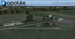
Opotiki aerodrome (ICAO: NZOP) is a small airstrip outside the township of of Opotiki, the gateway to the beautiful East coast of the North Island of New Zealand. Opotiki itself sits at the confluence of the Waioeka and Otara rivers and is surrounded by dairy farmland and Kiwifruit orchards with large areas of native bush to the south and east.
This scenery accompanies Tim Barnes'�� series of other small Bay of Plenty aerodromes (Whakatane,
Galatea, Waihi Beach) for use with VectorLandClass- It features custom modelled and textured buildings, large coverage of beautiful 0.5m aerial photography (fully auto-genned and including seasonal and night variations) and extensive use of high quality objects from the free VLC library. Installation of the library V1.1+ is required for this scenery to work properly and can be downloaded from the VectorLandClass website (www.vectorlandclass.co.nz)
This release, although not requiring it, works best with VectorLandClass topographic mesh and landclass addon covering all 268676 square kilometers of New Zealand. If you'��re not a VLC customer, you'��ll notice when the photoreal coverage runs out!
| Filename: | NZOP_Opotiki_Aerodrome_VectorLandClass_New_Zealand.zip |
| License: | Freeware, limited distribution |
| Added: | 21st February 2013, 13:52:47 |
| Downloads: | 969 |
| Author: | Tim Barnes |
| Size: | 146.68 MB |
| Category: Flight Simulator 2004 - Scenery | |
| Thames Estuary Airport - Version 2 |
|
Images related to this file:
File Description: This is the long awaited update to our original Thames Estuary scenery.
Version 1 is still available, but this is also 'stand alone' (version 1 not
needed)
Works with both FS9 and FSX. Seperate FSX version to follow.

Thames estuary airport is a possible new feature to the compilation of UK
airports. Using the concept images on the net, we have made the airport for FS9.
Please note that this is a very large airport and may not be suitable for slower
computers.
There have been plans since 1943 to build a new airport for London at various
locations around the Thames Estuary. The proposal was revived in 2008 by the
Mayor of London, Boris Johnson, and has acquired the nickname "Boris Island".
| Filename: | Thames_Estuary_Airport__Version_2.zip |
| License: | Freeware |
| Added: | 28th August 2013, 01:14:08 |
| Downloads: | 1,161 |
| Author: | Mark Piccolo - Soarfly Concepts |
| Size: | 903.4 KB |
| Category: Flight Simulator X - Scenery | |
| CYBL (2011) Version 2 for FS9, FSX and Prepar3D |
|
Images related to this file:
File Description:
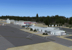
CYBL (2011) portrays the Campbell River (British Columbia, Canada) Airport and surrounding area, including the BC Forest Service tanker base, as it appeared in late 2011. (Campbell River, a small city mid-way up the eastern shore of Vancouver Island, is the "salmon capital" of North America and the gateway to Desolation Sound - summer cruising grounds for thousands of yachts from across the Pacific Northwest. Hence, CYBL is host to a lot of visiting GA.) This add-on includes a selection of Custom AI and static aircraft painted to represent aircraft based or often seen at CYBL. CYBL has recently completed a major runway extension and terminal upgrade - both of which are reflected in CYBL (2011). CYBL (2011) is compatible with BC Roads (FS9 only), ORBX FTX USA Canada Pacific Northwest and both FS9 and FSX versions of Ultimate Terrain.
Generally, this new version is visually identical to its predecessor - even though quite different internally. As well, to the extent possible, it is compatible with Prepar3Dv2. (v2.03 fixes a vehicle texture issue in 2.02)
| Filename: | CYBL_2011_Version_2_for_FS9_FSX_and_Prepar3D.zip |
| License: | Freeware, limited distribution |
| Added: | 22nd June 2014, 17:20:43 |
| Downloads: | 4,234 |
| Author: | Don Grovestine |
| Size: | 43.78 MB |
| Category: Flight Simulator X - Scenery | |
| Scappoose Industrial Airpark |
|
Images related to this file:
File Description:
Presenting KSPB Scappoose, Oregon Industrial Airpark, for FSX only. This is a nice area on the way from Portland, OR to St. Helens,OR around the Sauvie Island area.
ICAO is KSPB as mentioned above. VOWDME is 114.00 60nm range, ILS is 111.10 at 27 nm range.
This includes photo real file at high res for clarity. I made the red barn from pictures I found. One picture is included for comparison. This includes the mailbox and flower arrangement adjacent to it just for fun. Included are a few houses in the barn area and fencing which I did the best I could with what I have at the time.
Default vehicles and planes are added, but not too many so as not to cause frame rates issues. Included are a 55 Ford truck I made and one called fordtruck2 which is not as good as the '55 ford is, but I got in a rush...but it worked well. Enjoy. contact info is in the readme file. Bob
| Filename: | Scappoose_Industrial_Airpark.zip |
| License: | Freeware |
| Added: | 1st August 2012, 13:12:51 |
| Downloads: | 517 |
| Author: | Robert Lacy |
| Size: | 60.24 MB |
| Category: Flight Simulator 2004 - Scenery | |
| Tofino CYAZ 2012 |
|
Images related to this file:
File Description:
I've always had a particular fondness for Tofino CYAZ, located on the west coast of Vancouver Island. I made my first Tofino scenery in 2005 using Lago's FSE, and an updated version in 2006 using EZ-Scenery. Neither of those included custom models. This final version is a complete, from-the-ground-up rebuild. Every building and many of the other scenery objects are custom made based on photos and using photo textures. (The images in the "Tour" folder will take you on a tour of the real and virtual airport.) In the time since the first two virtual versions were made, a new terminal building has been added to the east ramp at the real Tofino, along with some new hangers, and the scenery includes these changes. Tofino has an NDB instrument approach (CYAZ NDB A.pdf), but night operations are not allowed. For this reason the new terminal building has no night lighting. The golf clubhouse restaurant and pro shop are open after dark for your shopping and dining pleasure. This scenery represents many hours of work...I hope you enjoy it.
| Filename: | Tofino_CYAZ_2012.zip |
| License: | Freeware |
| Added: | 19th August 2012, 14:33:09 |
| Downloads: | 650 |
| Author: | Sidney Schwartz |
| Size: | 10.14 MB |


© 2001-2026 AVSIM Online
All Rights Reserved
Privacy Policy |