
Where Flight Simulation Enthusiasts Gather from Around the World!
AVSIM Library - Search Results

| Category: Flight Simulator X - Aircraft Repaints, Textures and Modifications | |
| Douglas C-47 (PH-PBA) Rijksluchtvaartdienst |

|
Images related to this file:
File Description:
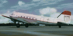
This folder contains a repaint for version 3.14 of the Douglas C-47 by Manfred Jahn and colleagues in the colors of PH-PBA. It was built as c/n 19434 and went to the 8th Air Force as 42-100971. She served among other during Operation Market Garden. After the war, she was obtained by Prince Bernhard of the Netherlands and registered as PH-PBA in 1946. In 1947, the Rijksluchtvaartdienst (RLD, Civil Aviation Authoroties) took her on charge, and from then on she served as the first Dutch Government aircraft, used mainly to fly the Dutch Royal family, often with Prince Bernhard as pilot. In 1961 she was replaced by a Fokker F-27, but continued to be used by the RLD, in the paintscheme presented here. In 1975, she was transferred to the Aviodome museum at Schiphol airport, where she stood outside for 20 years. Prince Bernhard always lobbied for a return to airworthiness for PH-PBA, and in 1995 she reappeared on the Dutch register. She is currently flying with the Dutch Dakota Association, in a combined KLM - Air France paintscheme. Repaint by Jan Kees Blom for Manfred Jahn's C-47 version 3.14, based on the paintkit by Gman5250.
| Filename: | Douglas_C47_PHPBA_Rijksluchtvaartdienst.zip |
| License: | Freeware |
| Added: | 16th August 2018, 16:27:19 |
| Downloads: | 173 |
| Author: | Jan Kees Blom |
| Size: | 7.62 MB |
| Category: Flight Simulator 2004 - Aircraft Repaints, Textures and Modifications | |
| SAAB 35XD Draken RDAF AR-116 |
|
File Description:
FS2004 SAAB 35XD Draken RDAF AR-116
This package contains textures only in Danish green paint scheme livery, for FS2004 Saab J 35J Draken 2.41 full package by Thomas Nilsson/Bookmark Digital Graphics. You will need the model j35j241.zip which can be found at AVSIM. SAAB 35XD Draken for Flight Simulator 2004 \nVersion 2.41 2006-03-20 \n© 2006 Thomas Nilsson/Bookmark Digital Graphics\The Saab 35 Draken is a supersonic interceptor using a double delta wing. The first prototype of this aircraft flew late in 1955, entering production in 1957. The aircraft is a single-seat, single-engine configuration equipped with 30mm cannons and air-to-air Sidewinder missiles. It can operate from small airfields due to its high thrust-to-weight ratio and the fitment of a parachute to assist with braking. In all, over 600 Drakens were built, the last example taking to the air 1972. For Denmark the Saab 35XD was developed. Based on the J 35F but was upgraded with more internal fuel, stronger gear, arrester hook, improved avionics and cockpit layout, new weapon pylons which resulted in redesigned outer wings. Three versions were built from the Saab 35XD variant: Here a single seat fighter repainted in the liverie of "AR-116" Esk.729.
| Filename: | SAAB_35XD_Draken_RDAF_AR116.zip |
| License: | Freeware |
| Added: | 28th April 2006, 02:52:18 |
| Downloads: | 358 |
| Author: | Claus Vendelboe Holmberg |
| Size: | 5.2 MB |
| Category: Flight Simulator 2004 - Scenery | |
| Northern Canada Mining CYOA & CHB3 in Canada |
|
Images related to this file:
File Description:
These are two airfields in northern Canada, serving two mining operations. The furthest north is Hope Bay CHB3 in Nunavut. It is in a sheltered inlet less than 3 miles from the northern mainland coast and around 65 miles southwest of Cambridge Bay. The owner is Hope Bay Mining Ltd, and their operation mines gold out of a tunnel rather than open cast. The airfield is incorporated into the road that leads north to the sea; traffic is halted by traffic lights when a flight is expected. The runway is 3,000 feet of gravel aligned 01-19 and with PAPI at both ends.
The second airfield serves the Ekati diamond mine and is some 265 miles southwest of Hope Bay, in the Northwest Territories. Ekati was the first Canadian diamond mine and is 195 miles northeast of Yellowknife and less than 20 miles north of a later mine, Diavik (by Sid and Pete). CYOA reflects the relative value of the two mining operations and is far better equipped than Hope Bay. It can be described as an airport while Hope Bay remains an airfield. The runway is 6,400 feet of gravel aligned 36-18 with PAPI and strobe approach lights at both ends. The scale of the mining operation can only be described as huge.
| Filename: | Northern_Canada_Mining_CYOA__CHB3_in_Canada.zip |
| License: | Freeware, limited distribution |
| Added: | 11th August 2018, 22:59:06 |
| Downloads: | 219 |
| Author: | Roger Wensley |
| Size: | 8.24 MB |
| Category: Flight Simulator X - Gauges | |
| Advanced Radar System (ARS) |
|
Images related to this file:
File Description:
This Advanced Radar System (ARS) Version 1.0 displays AI traffic of FSX in a range of
5, 10, 20, and 40 miles.The ARS contains an AI tracking function, which allows you
to follow a selected AI automatically in terms of course and speed. In this mode
the ARS is coupled with the autopilot of your aircraft. The ARS feeds the
autopilot with the AI heading and speed data. The tracking mode can be
switched on or off.
An air fuel gauge is included in the ARS package also, which allows you to
perform an air re-fuel procedure for your aircraft. A air refueling can be done
from each AI aircraft if you have decided to use it as your tanker. The decision
will be done via a select function from the ARS panel and in addition via a
dedicated activation on the air fuel panel.For installation, look at the ARS_DOC folder.
(the folder is now included in the zip !!!!!!!!!! It was not in the previous upload. Sorry!)
COPYRIGHTS
This gauge is freeware. All rights are reserved and no part of the package may
be duplicated or distributed without the expressed, written permission of the
author.
CREDIT goes to: Bob Familton for his review of the documentation and testing
for SP1 FSX.
| Filename: | Advanced_Radar_System_ARS.zip |
| License: | Freeware |
| Added: | 2nd February 2011, 20:33:29 |
| Downloads: | 2,886 |
| Author: | Dietmar Loleit |
| Size: | 1.05 MB |
| Category: Flight Simulator 2004 - Scenery | |
| Fort Liard CYJF in the Northwest Territories, Canada |
|
Images related to this file:
File Description:
Fort Liard is the seventh in a series of airfields that follow (approximately) the Mackenzie River. At the far northern end of the river there is Tuktoyaktuk, then Inuvik, Fort McPherson, Fort Good Hope, Deline, Wrigley, and then Fort Simpson Island and Fort Simpson, all posted. Fort Liard is at 708 feet asl and on the east bank of the the Liard River, around 130 miles south of Fort Simpson where the Liard and Mackenzie join, and about 25 miles from the borders with both British Columbia and the Yukon. The town has a population of about 560 folks.
The airport is next to the town, and has almost 3,000 feet of gravel runway. I have no information regarding when it was built but it may be from the WW2 time; the cleared and grassed area is long enough for a runway 0f 6,000 feet. There are no scheduled flights but North Cariboo Air have a base at the airport for local charters to support survey teams etc. and are almost an on-demand-scheduled airline. I have also added a Buffalo DC3 and GA. There is fuel available, but only by prior arrangement with North Cariboo. Right hand circuits for runway 20.
| Filename: | Fort_Liard_CYJF_in_the_Northwest_Territories_Canad.zip |
| License: | Freeware, limited distribution |
| Added: | 11th July 2014, 13:38:49 |
| Downloads: | 304 |
| Author: | Roger Wensley |
| Size: | 10.07 MB |
| Category: Flight Simulator 2004 - Scenery | |
| TNCS - Juancho E. Yrausquin Airport - Saba, Netherlands Antilles |
|
Images related to this file:
File Description:
This island is the smallest municipality of the Netherlands. Saba is just under 30 miles south of St. Maarten, the island that was split between France and the Netherlands; to the southeast and 20 miles away is the small island of St. Eustatius, then St Kitts and then Nevis. The island comes out of the water like the top of Everest and keeps going, and there is no large space for a runway and no possibility of creating one with landfill with those steep sea cliffs. So what you have is a small runway (aligned 12/30) of 1,000 feet plus over-runs at each end that have small "closed" markings (see the white crosses) for a usable total of around 1,300 feet.
The airport restricts access as there is only space for four planes to park, plus a helicopter. And of course there is also the short runway to contend with. Landings are carried out under waivers issued by the Netherlands Civil Aviation Authority, and will always be on runway 12 as the southeast trade winds predominate. Twotters land there but only in real life; FS9 AI Twotters don't seem to find it adequate. There is no fuel or any other facility except for a small terminal building and a car park.
| Filename: | TNCS__Juancho_E_Yrausquin_Airport__Saba_Netherland.zip |
| License: | Freeware, limited distribution |
| Added: | 8th May 2013, 02:52:26 |
| Downloads: | 1,502 |
| Author: | Roger Wensley |
| Size: | 3.09 MB |
| Category: Flight Simulator 2004 - Aircraft Repaints, Textures and Modifications | |
| RAAF Avro York MW140 |
|
File Description:
textures for Classic British Flight Sim avro york. First Flight 10/11/44. Delivered RAF 246 Sqn 09/02/45. Transfered to RAAF as 'Endeavour' and allocated A74-1 10/03/45. To 1 AD 19/03/45. To Governor Generals Flight 02/04/45. To 17 RSU for engine change 10/04/45. To Governor Generals Flight 11/04/45. Although the RAAF identification number A74 was allocated, the York retained the original serial MW140, but the RAF markings were exchanged for the contemporary RAAF blue and white roundels and flashes. The York was used for long-range flights including the Duke's tour of New Guinea, New Britain, and Bougainville Island. The flight was terminated on July 5 1945, because of the death of the Prime Minister, the Rt Hon John Curtin. On two occasions, September 20 1945, and October 5 1945 "Endeavour" was flown to Singapore to evacuate ex-POWs, and on the first return journey a record flight was established between Perth and Canberra. On January 17 1947, "Endeavour" departed from Mascot and arrived in England on January 23 1947, where the aircraft was handed back to the Air Ministry. 06/01/48, RAF 24 Sqn. 03/52, Withdrawn & stored RAF 12MU Kirkbride, Cumbria, UK, 07/09/54 Aviation Jersey - later broken up. Although allocated A74-1, it was never applied to the aircraft
| Filename: | RAAF_Avro_York_MW140.zip |
| License: | Freeware |
| Added: | 1st July 2008, 13:14:52 |
| Downloads: | 280 |
| Author: | matt levi |
| Size: | 656.77 KB |
| Category: Flight Simulator X - AFCAD Files | |
| Princeton Airport (39N), NJ |
|
File Description:
Located 03 miles N of Princeton/Rocky Hill, New Jersey on 100 acres of land, Princeton Airport is a public airstrip. Fuel is available by parking next to the fuel tank - make sure you leave yourself enough room to get back out! (The block of static aircraft parked near the fuel area have collision disabled). This airport offers hangar space for transient aircraft, and as such 5 hangars are open that you can park in - the large hanger and the 4 surrounding it, 2 to the north and 2 to the south. The large hangar has operating doors - the frequency to open them is posted on the hangar doors. You can also choose to start in one of the hangars by selecting a DOCK parking space when positioning yourself at the airport. Docks 16 & 17 are the two small north hangars, Dock 20 is the large central hangar and Docks 18 & 19 are the two small south hangars.
Scenery constructed with use of satellite images/streetview, the author has not been there in person.
This scenery is meant to be used in conjunction with MegaScenery Earth New Jersey/Delaware 001. It is not required, but apron use is minimized to allow satellite scenery to show through as much as possible, and objects are placed based on the MSE textures - lack of it may make scenery look out of place.
| Filename: | Princeton_Airport_39N_NJ.zip |
| License: | Freeware |
| Added: | 21st November 2010, 09:01:50 |
| Downloads: | 311 |
| Author: | Drew Sikora |
| Size: | 1.26 MB |
| Category: Flight Simulator X - Scenery | |
| YCDN Corunna Downs Station and Old Corunna Downs RAAF (Closed) |
|
File Description:
Corunna Downs heritage listed RAAF Base was a secret airfield located in scrub and spinifex country, about 16 kms south west of Marble Bar, the hottest part of the "The Pilbara" area of Western Australia. Not a very ideal place to have a tent city. Today there are very few reminders of the once busy airfield. One can see some crumbling foundations and half filled post holes. 73 OBU operated the Corunna Downs airfield which comprised two intersecting bitumen runways, now regressed and graded occasionally. One ran approximately north-south, 5,000 feet in length while the other ran approximately east-west, 7,000 feet in length. Both runways were approximately 150 feet wide. A 50 foot wide taxiway linked the northern end of the north-south runway to the western end of the east-west runway. Approximately 20 camouflaged revetments to disperse aircraft to minimise bomb damage were constructed at Corunna Downs. Permission is required for landing and there may be vegetation on the strip if not graded recently. No cones or windsock so be careful. Corunna Downs Homestead is also heritage listed and consists of graded strips and homestead complex. Start points are at the homestead and the RAAF base is to the west. REQUIRES Blencowe_LibraryKit.zip
REQUIRES blencowe_librarykit_309494.zip (Available HERE)
| Filename: | YCDN_Corunna_Downs_Station_and_Old_Corunna_Downs_R.zip |
| License: | Freeware |
| Added: | 25th February 2013, 08:59:42 |
| Downloads: | 283 |
| Author: | Alan Blencowe |
| Size: | 4.92 MB |
| Category: Flight Simulator X - Scenery | |
| YEEB Eneabba, Western Australia strip and townsite |
|
File Description:
YEEB Eneabba strip and townsite
Sand mining town in heart of wildflower area Located 278 km north from Perth via the Brand Highway, Eneabba is basically a sand mining town surrounded by some of the most extensive and spectacular wild flower displays anywhere in Western Australia. The town itself is, to be fair, a real non-event with dreary modern housing (with more than a hint of construction town design), a small shopping centre and a service station all of which look as though they have sprung up in the last 20-30 years. The wealth of the area is based on the rutile sands which lie to the south of the town as well as farming, particularly cattle grazing. With an estimated 80 per cent of the world's known rutile supplies the town can boast that it has the biggest deposits of rutile in both Australia and the world. The major mining company in the area is Iluka Resources Ltd. Eneabba is basically a service town for the mines but some of the miners, realising that Eneabba is hardly a paradise, have opted for commuting and live on the coast at Leeman and drive to work preferring the beach to the dry inland.
REQUIRES blencowe_librarykit_309494.zip (Available HERE)
| Filename: | YEEB_Eneabba_Western_Australia_strip_and_townsite.zip |
| License: | Freeware |
| Added: | 25th February 2013, 23:48:24 |
| Downloads: | 255 |
| Author: | Alan Blencowe |
| Size: | 3.59 MB |


© 2001-2026 AVSIM Online
All Rights Reserved
Privacy Policy |