
Where Flight Simulation Enthusiasts Gather from Around the World!
AVSIM Library - Search Results

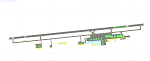
| Category: Flight Simulator X - AFCAD Files | |
| TISX - Henry E. Rohlsen Airport / Christiansted, St. Croix, US Virgin Islands |

|
Images related to this file:
File Description:
TISX - Henry E. Rohlsen Airport / Christiansted, St. Croix, USVI
This airport update was made with the latest version of ADE (Airport Design Editor) and made for FSX as a replacement for the stock (default) airport. I've made several changes to the airport which are listed below. All these enchancements are as close to the real airport as I can get with stock library objects. I've used satellite images, terminal photos and maps throughout the whole process so building locations are as accurate as possible. Happy landings in the serene United States Virgin Islands!
Features:
Expanded parking apron, Main terminal building with parking area for commercial traffic
Seperate parking area for GA traffic, Misc airport buildings added
Airport vehicles and objects throughout the airport, Fuel tanks and vehicles
Coconut trees, Expanded runway as per latest charts
Expanded taxiways as per latest charts, Military cargo area
Commercial cargo area
| Filename: | TISX__Henry_E_Rohlsen_Airport__Christiansted_St_Cr.zip |
| License: | Freeware |
| Added: | 23rd October 2012, 18:37:47 |
| Downloads: | 785 |
| Author: | Jaison Diaz / Endeavour AI |
| Size: | 109.69 KB |
| Category: Flight Simulator X - AFCAD Files | |
| ZBTJ - Tianjin Binhai Intl. - Tianjin, China |
|
Images related to this file:
File Description:
ZBTJ - Tianjin Binhai International Airport is an airport located in Dongli District, Tianjin. It is one of the major air cargo centers in the People's Republic of China. It is the hub airport for Tianjin Airlines, established in 2004, and privately owned Okay Airways. It's also a focus city for Air China.
International flights are primarily operated by Korean Air and Asiana Airlines to Seoul-Incheon international Airport, Japan Airlines to Nagoya-Chubu Centrair International Airport.
Construction of a new terminal began in 2005 and was fully operating by 2008. The airport expansion provides a state-of-the-art terminal building, which is more than three times bigger than the current one at 116,000 m2. In May 2009, the airport has also completed the construction of a second runway, and the expected number of passengers will exceed ten million.
Using ADEx 1.50, SBuilderX, aeronautical maps and Google Earth (2011) all these changes have been built into the default FSX airport to better reflect todays situation.
| Filename: | ZBTJ__Tianjin_Binhai_Intl__Tianjin_China.zip |
| License: | Freeware |
| Added: | 2nd October 2012, 23:01:45 |
| Downloads: | 2,075 |
| Author: | Menno C. Robert |
| Size: | 2.7 MB |
| Category: Flight Simulator X - Scenery | |
| Hawaiian Airports Part 1 |
|
Images related to this file:
File Description:
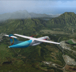
Hawaiian Airports Part 1
This scenery features accurate recreations of the airports at PHMK Molokai, PHNY Lanai City, PHHN Hana, PHLU Kalaupapa, and JHM Mauai West. All runways, aprons, taxiways and buildings have been repositioned to their correct locations, and include custom textures based on real photographs. The new hanger has been added to Hana and also the new fire stations at Lanai and Molokai. The scenery features effects, sound, many animated objects including people, flags, animals, waves, cars, trucks and many more. Full night textures with light maps are included.
The scenery also includes representative, and real interisland traffic schedules, and the HAL ATR is sporting the new OHana livery.
All the scenery files have been sub-divided so they can be switched on or off according to user preference. It has been designed for, and tested in DX9 and FSXA only.
Please enjoy, and I hope you like my scenery as much as I enjoyed building it.
| Filename: | Hawaiian_Airports_Part_1.zip |
| License: | Freeware, limited distribution |
| Added: | 15th January 2014, 11:11:37 |
| Downloads: | 12,326 |
| Author: | George Keogh |
| Size: | 231.29 MB |
| Category: Flight Simulator X - Gauges | |
| FIP - 5 Gauge Display - 2 Engine |
|
Images related to this file:
File Description:

This set of gauges is for use in the Saitek FIP and has been developed specifically for the Baron 58 and variants but should work with other twin prop aircraft. There are 3 options-
option 1. a pair of gauges for displaying on 2 FIPs (layout is similar to the fsx BB58 layout)
option 2. One gauge for displaying only on 1 FIP (left and right eng needle on each of the 5 main instruments )
option 3. a pair of gauges for displaying on 2 FIPs with larger diameter gauges and more user interaction than in 1. above.
1,2, & 3 all have the 5 main engine instrumentation ( RPM, Manifild Pressure, Fuel Flow rate, Oil Temp and Pressure, CHT/EGT Temp.) Additional features are added .e.g Marker Beacon indicators plus indicator of left / right fuel tank selected for each engine, NAV 1 & NAV 2 with DME data.
Option 1 & 3 also has fuel pump switches, alternator switches, starter buttons, cowl flaps and Amps (total load) gauge, and Battery volts gauge.
Option 3 also has additional avionics data and avionics and battery switch buttons. All this enables the aircraft to be started from cold and shut down to cold. The avionics data is useful if you only have one Saitek radio panel. i.e. dont have to keep clicking / rotating switches all the time. This option also gives user ability to alter NAV 1 standby frequency and swap to active.
With the 2 gauges in option 3 above plus my earlier FIP gauge containing a working Auto pilot and fuel levels / flaps and landing gear indicators (refer "FIP-AP Multi Fuel Gauges") there is everything required (not the primary flight display instruments) for flying a single or twin prop aircraft displayed across either 2 or 3 FIPs.
| Filename: | FIP__5_Gauge_Display__2_Engine.zip |
| License: | Freeware |
| Added: | 30th October 2014, 06:24:58 |
| Downloads: | 250 |
| Author: | Robert Budd |
| Size: | 2.4 MB |
| Category: Flight Simulator X - Missions | |
| Discover FSX Flight (PAFA - PABR) (486 NM) (Heavy Cargo Run) |
|
File Description:
(PAFA - PABR) (486 NM) (Heavy Cargo Run)____Situation Orientation (Fictional) : Twice a year, (GREEN SOLUTIONS) a joint US-UN funded scientific research firm, based in Anchorage Alaska, charters a freighter jet to make a cargo run to (Barrow/Alaska (PABR)) located near the beaufort sea / Arctic ocean, where one of the firm's major research facilities is located. For the September run, it has been arranged that the flight will make a stop over at Fairbanks International Airport- Alaska (PAFA) to pick up additional cargo that a supplier working with the firm shipped to Fairbanks by train. As this run is a pre-winter run, the cargo is heavy and the cargo company have allocated a large freighter ship to handle the heavy cargo load. The aircraft arrived into Anchorage inbound from South America early this morning and departed Anchorage at 11:00 am. It arrived PAFA on time and is loading the additional cargo at a designated hanger. The flight was shedualedto depart to Barrow at 2:30 pm butfreighter paperwork and administrative complexities have caused a two and a half hour delay. Everyone, including you,is frustrated and anxious to get moving. Finaly, ground crews inform you that you will be ready to go in 10 ____Note : Although no significant malfunctions where logged during the first leg of the flight, the aircraft's maintenence logs indicate that during its Panama City departure,the crew logged an abnormalylow climb attitude after take off. However, due to compressed schedual timetables, maintenance operations in Anchorage decided that maintenance would be done after it returned from its charter flight and have given it a green light. As first officer, the captain has instructed you to watch that closley as he has given you control of this leg.
| Filename: | Discover_FSX_Flight_PAFA__PABR_486_NM_Heavy_Cargo_.zip |
| License: | Freeware |
| Added: | 30th September 2007, 15:11:13 |
| Downloads: | 5,090 |
| Author: | Ali Zied |
| Size: | 391.35 KB |
| Category: Flight Simulator X - Gauges | |
| TCAS and Traffic Display Gauge V2.0 |
|
Images related to this file:
File Description:
This TCAS and Traffic Display Gauge Version 2.0 includes significant improvements from V1.0. It has been developed for the FSX Flight Simulator SP1/2 also. It should also work with Acceleration.The functionality for the TCAS part is based on general specs for commercial aircrafts. It does not provide in detail the function for a specific aircraft model. It is a generic gauge, and can be simple added to any aircraft as a standalone popup window.
In addition the gauge provides a AI traffic display in the ranges of 10,20, and 40 miles.Within this display mode, no TCAS rules are valid, which means all AI aircraft are displayed independent of any altitude or distance.
Improvements in V2.0 are: 1: Full TCAS and traffic display capability is provided even though your aircraft is on the ground. Only the trigger of the alarm/warn sound and the blinking lamp display willbe blocked. 2: An AI HDG pointer will be displayed. It shows in which direction the AI is moving. 3: A bearing pointer has been introduced. It allows the pilot to point to a specific AI.4: The AI additional text info display follows the structure of an ATC text.5:The AI additional text can be selected individually per AI with a mouse click.
6: Each AI display contains a ID index number (0 � 20).7: The design of the TCAS and Traffic Display Box has been updated.8: Increased the number of AIs displayed on the screen in display mode.
For installation and functional description look at the doc inside the ZIp.
CREDIT goes to :
Stefan Schneider for his support on special XML issues and TCAS functionality.
Bob Familton for his review of the documentation and testing for SP1 FSX.
Doug Dawson for his dsd-XML-sound interface in order to generate the sounds.
| Filename: | TCAS_and_Traffic_Display_Gauge_V20.zip |
| License: | Freeware |
| Added: | 25th October 2010, 13:37:36 |
| Downloads: | 3,748 |
| Author: | Dietmar Loleit |
| Size: | 981.32 KB |
| Category: Prepar3D V1-4 - Scenery | |
| Bloukrans and Storms River (Paul Sauer) bridges – South Africa |
|
Images related to this file:
File Description:

The Bloukrans and Paul Sauer (over the Storms river) bridges are on the N2 highway between Plettenberg Bay and Port Elizabeth on the scenic garden route in the Eastern Cape, South Africa. I made the custom scenery to try some Blender techniques using the P3D 4.5 SDK and tested it in P3D V5 using the ORBX Africa LC and Pilots NG2020 mesh products (I included a fix for the default V5 mesh). You will find the world's highest commercial bungee jump from the Bloukrans bridge, 216m above the river below. Take off from FAPG and fly a heading of 95 degrees for 32 km to get to the Bloukrans bridge (just off the coast). Follow the highway further east for another 26 km to get to the 120m high Paul Sauer bridge, where I included some additional eye candy.
| Filename: | Bloukrans_and_Storms_River_Paul_Sauer_bridges__Sou.zip |
| License: | Freeware |
| Added: | 14th July 2020, 19:15:53 |
| Downloads: | 179 |
| Author: | Johan Pienaar |
| Size: | 26.95 MB |
| Category: Prepar3D V1-4 - Utilities | |
| FS Flight Builder |
|
Images related to this file:
File Description:
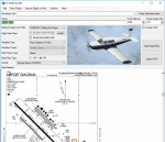
FS Flight Builder is a utility for general aviation flying that will build flight files for FSX (flt), FSX Steam Edition (flt), and Prepar3D (fxml) based on waypoints and other data either entered manually or imported from SkyVector using the Plain Text Link information. Among other things, you can select your starting position, aircraft, and a VFR or IFR flight plan.
One of the most interesting features of the application is that it will include a Briefing file, added to the aircraft's built-in kneedboard, that will include departure and destination airport information (runways, frequencies, weather, and charts) as well as navigation frequencies along the route.
Included is a new destination chooser function that allows you to enter your departure airport and additional criteria, such as min and max distance, tower required, ILS, runway length restrictions.
| Filename: | FS_Flight_Builder.zip |
| License: | Freeware |
| Added: | 30th July 2018, 03:56:07 |
| Downloads: | 148 |
| Author: | Tom Arduini |
| Size: | 28.24 MB |
| Category: Flight Simulator X - Scenery | |
| KMKJ - Mountain Empire Airport - Virginia, USA |
|
Images related to this file:
File Description:
Mountain Empire Airport (ICAO: KMKJ, FAA LID: MKJ) is a public use airport in Smyth County, Virginia, United States.[1] It located nine nautical miles (10 mi, 17 km) northeast of the central business district of Marion (in Smyth County)[1] and 13 nautical miles (15 mi, 24 km) west of Wytheville (in Wythe County).[2] The airport is situated between Interstate 81 and U.S. Route 11 (Lee Highway), near Groseclose. It is owned by Smyth Wythe Airport Commission.
This is a complete re-work of the airport. Added taxiway, additional parking aprons and custom buildings.
Created with Airport Design Editor by ScruffyDuck Software using current FAA documentation and Google Earth measurements, this package offers a replacement for FSX's stock airport. All these enhancements are as close to the real airport as I can get with stock library objects and custom buildings.
| Filename: | KMKJ__Mountain_Empire_Airport__Virginia_USA.zip |
| License: | Freeware |
| Added: | 25th January 2015, 15:55:52 |
| Downloads: | 308 |
| Author: | Wayne Roberts |
| Size: | 339.5 KB |
| Category: Flight Simulator X - Scenery | |
| W91 - Smith Mountain Lake Airport - Moneta, Virginia, USA |
|
Images related to this file:
File Description:
The Smith Mountain Lake Airport (FAA W91) is a
privately owned airport open to the public located 4
miles (6.4 km) southeast of Moneta, in Bedford
County, Virginia, USA. The facility serves primarily
general aviation for the areas around Smith Mountain
Lake. In November of 2013, longtime airport owner Joe
Borgess sold the airport to a New Jersey couple for
approximately one million dollars. Mark A. Dalton, of
Mark A. Dalton & Company REALTORS in Lynchburg, VA
brokered the sale.
Added and adjusted aprons and buildings. Also added
additional parking and custom models.
Created with Airport Design Editor by ScruffyDuck
Software using current FAA documentation and Google
Earth measurements, this package offers a
replacement for FSX's stock airport. All these
enhancements are as close to the real airport as I
can get with stock library objects and custom
buildings.
| Filename: | W91__Smith_Mountain_Lake_Airport__Moneta_Virginia_.zip |
| License: | Freeware |
| Added: | 16th December 2014, 14:45:37 |
| Downloads: | 282 |
| Author: | Wayne Roberts |
| Size: | 387.31 KB |
© 2001-2026 AVSIM Online
All Rights Reserved
Privacy Policy |