
Where Flight Simulation Enthusiasts Gather from Around the World!
AVSIM Library - Search Results

| Category: Flight Simulator 2004 - Scenery | |
| NZAA auckland airport for fs9/fs2004 |

|
File Description:
Auckland Airport[5] (IATA: AKL, ICAO: NZAA) is an international airport serving Auckland, the most populous city of New Zealand. It is the largest and busiest airport in the country, with over 16 million passengers served in the year ended August 2023.[6] The airport is located near Māngere, a residential suburb, and Airport Oaks, a service-hub suburb 21 kilometres (13 mi) south of the Auckland city centre. It serves as the principal hub for Air New Zealand and the New Zealand operating base for Jetstar.
Features of this scenery include:
1)Highly modeled terminals and buildings
2)roads and highways
3)surrounding warehouses
4)Custom ground poly LINES
5)lots of ground equipment
6)3d grass
7)trees----> have seasonal issues but will update once fixed
8)cars and fences
9)custom textures and night lighting
10)2 major hotels near the international terminal
11)Accurate taxiways and hangars
12) Localizer antennas
13)street lights
Please put these files in the addon scenery folder of your FS9 directory
And add in fs
They shouldn't cause any issues.
(http://www.mediafire.com/file/emh3ksaq3nd7igk/real_new_zealand_auckland_city.rar) link for the city.
| Filename: | NZAA_auckland_airport_for_fs9fs2004.zip |
| License: | Freeware |
| Added: | 26th April 2025, 14:00:30 |
| Downloads: | 368 |
| Author: | Jeremy Paul Joby |
| Size: | 91.51 MB |
| Category: Flight Simulator X - Scenery | |
| LSZB Bern Belp, Switzerland for FSX (P3D) Version1.0 |
|
Images related to this file:
File Description: This scenery is very detailed in design fitting the newest airport layout from 2017. All important buildings are new designed, partly recreated by basicly using objects from the Sketchup Warehouse. Nighttextures are completely integrated. The surrounding area was adapted to the real surroundings by new landclasses. Also the mesh round the airport is adjusted. There are three Photobackgrounds aviable fitting the FSX standardscenery (all seasons), the Switzerland ProX (summer and winter) and Mega Scenery Earth (only summer). RECOMMENDED LIBRARIES:
Many smaller objects, such as people, cars, or static planes in this scenery, are taken from three popular freeware libraries, for which I got the kind permission of the authors. If these libraries are not installed, many objects are not visible! The following libraries are used: 1. FS-Piloten_Objektlibrary:
http://www.fs-piloten.de/thread.php?threadid=1063 2. FSX_FlightPortLib
http://www.flightport.de/libraries/flightport-library/ 3. 3d People Library and 3d People Library BUGFIX
https://library.avsim.net/search.php?SearchTerm=people+3d&CatID=fsxsd&Go=Search
| Filename: | LSZB_Bern_Belp_Switzerland_for_FSX_P3D_Version10.zip |
| License: | Freeware |
| Added: | 13th June 2017, 00:24:32 |
| Downloads: | 5,212 |
| Author: | Wolfgang Allers |
| Size: | 370.96 MB |
| Category: Prepar3D V1-4 - Scenery | |
| KLVN - Airlake Airport - Lakeville, MN, USA |
|
File Description:
KLVN - Airlake Airport beta version .4 - by Jason Boche
This is an update of the default P3Dv4.5 KLVN airport. Aside from the original 12/30 runway, everything else at this airport has been completely ripped and replaced.
Enhancements include:
-Extended runway on each end to depict current configuration
-Accurate taxiways including Hamburg Ave. and buildings representing the current general aviation hangars
-Added navigational equipment on the field
-Added a few asphault and dirt service roads
-Added FBO and other buildings as close as I could match them
-Added some general aviation aircraft, civilians, vehicles at the FBO and hangars, and two fuel trucks
-Moved fuel station to where I believe it is currently according to Google maps with 100LL fuel trigger functional
-Moved the windsock to accurate location
-Moved the beacon to accurate location
-Moved GA parking spots
-Added trees around FBO and beacon
-Added utility poles
-Added a few square miles of Lakeville city, farm, and residential land class and autogen according to Google maps. This is probably the biggest improvement. It now looks like people live, work, and shop north/northwest of KLVN.
-Reworked the runway 12/30 blast pads to what I believe is the "proper" method. Instead of freehand polygon asphault, they are now actual runway extensions on both ends with yellow chevron markings
-Reworked the land class on the southwest end of the airport where I believe hangar expansion is intended. Prior to this, there was a sharp contrast between where the KLVN airport boundary ended and where generic farm landclass began which was right in the middle of the southwest taxiways and it looked bad. Now that whole region is grass and looks to be part of the airport parcel.
-Minor building adjustments west of the FBO to better match actual placement.
-Fixed a gap on the southeast end of Hamburg ave taxiway where it rounds the corner for the rwy 30 hold short line
-Randomized the directional facing of some of the cars parked at GA hangars
-Renumbered the parking spots 1-4 with #5 being the refueling spot
-Reversed the start direction of parking spots 1-3.
-Pulled the refueling parking "start" spot back because on start the engine cowling & prop were too far forward inside the fuel pump equipment
-Added an autogen exclusion to the rwy 12 short final due to trees popping up on short final path.
-KLVN tower viewpoint 25 meters above FBO.
-Removed the perimeter fence around the entire field
| Filename: | KLVN__Airlake_Airport__Lakeville_MN_USA.zip |
| License: | Freeware |
| Added: | 13th May 2020, 17:18:40 |
| Downloads: | 84 |
| Author: | Jason Boche |
| Size: | 14.81 KB |
| Category: Flight Simulator X - AFCAD Files | |
| KLVN - Airlake Airport - Lakeville, MN, USA |
|
File Description:
KLVN - Airlake Airport beta version .3 - by Jason Boche
This is an update of the default FSX KLVN airport. Aside from the original 12/30 runway, everything else at this airport has been completely ripped and replaced.
Enhancements include:
-Extended runway on each end to depict current configuration
-Accurate taxiways including Hamburg Ave. and buildings representing the current general aviation hangars
-Added navigational equipment on the field
-Added a few asphault and dirt service roads
-Added FBO and other buildings as close as I could match them
-Added some general aviation aircraft, civilians, vehicles at the FBO and hangars, and two fuel trucks
-Moved fuel station to where I believe it is currently according to Google maps with 100LL fuel trigger functional
-Moved the windsock to accurate location
-Moved the beacon to accurate location
-Moved GA parking spots
-Added trees around FBO and beacon
-Added utility poles
-Added a few square miles of Lakeville city, farm, and residential land class and autogen according to Google maps. This is probably the biggest improvement. It now looks like people live, work, and shop north/northwest of KLVN.
-Reworked the runway 12/30 blast pads to what I believe is the "proper" method. Instead of freehand polygon asphault, they are now actual runway extensions on both ends with yellow chevron markings
-Reworked the land class on the southwest end of the airport where I believe hangar expansion is intended. Prior to this, there was a sharp contrast between where the KLVN airport boundary ended and where generic farm landclass began which was right in the middle of the southwest taxiways and it looked bad. Now that whole region is grass and looks to be part of the airport parcel.
-Minor building adjustments west of the FBO to better match actual placement. Will only be shown on high scenery detail.
-Fixed a gap on the southeast end of Hamburg ave taxiway where it rounds the corner for the rwy 30 hold short line
-Randomized the directional facing of some of the cars parked at GA hangars
-Renumbered the parking spots 1-4 with #5 being the refueling spot
-Reversed the start direction of parking spots 1-3.
-Pulled the refueling parking "start" spot back because on start the engine cowling & prop were too far forward inside the fuel pump equipment
-Added an autogen exclusion to the rwy 12 short final due to trees popping up on short final path.
-KLVN tower viewpoint 25 meters above FBO.
-Removed the perimeter fence around the entire field
| Filename: | KLVN__Airlake_Airport__Lakeville_MN_USA.zip |
| License: | Freeware |
| Added: | 22nd November 2013, 23:26:10 |
| Downloads: | 225 |
| Author: | Jason Boche |
| Size: | 446.33 KB |
| Category: Flight Simulator X - Aircraft Repaints, Textures and Modifications | |
| Centurion Cargo "Petete" McDonnell-Douglas MD-11F (N701GC) |
|
Images related to this file:
File Description:
Centurion Cargo is a privately owned company founded in 2001. Based at
Miami International Airport, it currently operates a fleet of ten MD-11F,
and has an impressive 550,000 square foot warehouse, divided into two
different sections, a 159,000 square foot cooler and 391,000 square foot
Dry Cargo Area. The Centurion Cargo Center is by far the largest privately
owned all cargo airline facility in North America.
Centurion is one of the leading cargo airlines operating to and from
Latin America and is No. 1 in the handling of live animals and perishable
goods. Centurion has recently expanded its network to include 4 weekly flights
from Amsterdam, The Netherlands. We also offer worldwide charter, handling, and
security services among others.
FSX McDonnell-Douglas MD-11F repaint textures for the real world
Centurion Cargo N701GC, named "Petete", but with the freeware version's Pratt
and Whitney engines. For the freeware SMS Overland MD-11 with P&W 4460 engines,
which you must have previously installed in FSX. I installed the freeware
(SMS-MD-11_Dutch_Package.zip) with VC which works well with this repaint.
Also includes engine exhaust smoke coordinates which you can add to
your "aircraft.cfg" if you wish. Screenshots enclosed. Easy installation.
Repaint by Tom Tiedman.
| Filename: | Centurion_Cargo_Petete_McDonnellDouglas_MD11F_N701.zip |
| License: | Freeware |
| Added: | 20th July 2013, 07:14:54 |
| Downloads: | 160 |
| Author: | Tom Tiedman / SMS Overland |
| Size: | 7.86 MB |
| Category: Flight Simulator X - Aircraft Repaints, Textures and Modifications | |
| FSX/P3D Trans-Texas Airways DC-3/C-47 circa 1962 |
|
Images related to this file:
File Description:
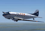
This is a repaint of the DC-3 in Trans-Texas Airways colors. The freeware DC-3/C-47 v3 by Manfred Jahn is needed for this repaint. Trans-Texas Airways (TTA) began operations in 1940, at Houston, as an aircraft sales and service company named Aviation Enterprises. The name was changed to Trans-Texas Airways on June 21 1947, and scheduled Douglas DC-3 services were inaugurated on October 11. Initially, Trans-Texas Airways flew routes only within Texas, but the key year in the history of Trans Texas Airways was 1966. That year its route network was significantly strengthened by the acquisition of new feeder routes from Eastern Airlines. This gave them virtual control of the entire feeder route system of the U.S. Southwest. Following this, TTA became an international airline in August 1967, with flights to Monterrey, Tampico, and Vera Cruz in Mexico. The expansion, however, created financial difficulties for TTA. This led to a takeover of TTA, in late 1968, by Minnesota Enterprises. The stockholders then voted to change the company name and corporate image the following spring. Thus, on March 1 1969, Trans-Texas Airways became Texas International Airlines. Textures are DXT5. This repaint was tested on FSX-SE and should work on FSX & P3D v1-3.
| Filename: | FSXP3D_TransTexas_Airways_DC3C47_circa_1962.zip |
| License: | Freeware |
| Added: | 3rd December 2018, 17:20:01 |
| Downloads: | 173 |
| Author: | Ted Giana |
| Size: | 7.94 MB |
| Category: Flight Simulator X - Scenery | |
| RNAS Twatt (HMS Tern) |
|
File Description:
Opened on the 1 April 1941 RNAS (HMS Tern) was used throughout the second world war by various Sqns of the Royal Navy undergoing training.
The station had 4 concrete runways with various hangers and the usual building associated with a military base. It was also the first unit in the UK to experience a helicopter crash when a Sikorsky helicopter getting ready for take off; hit a parked Blenheim.
The UK and Iceland where involved in what was called the cod wars in the early 1970s, and NATO was concerned that it would have to remove its bases from Iceland should the dispute escalate between the 2 countries and there was talk of Twatt becoming a NATO base. However, this did not happen and the idea was dropped.
There was also talk of the unit becoming a base for helicopters supporting the oil industry, however, as a result of the drop in oil prices during the 80s that idea was also dropped.
Most of the airfield has been returned to farming now with only the unique Control Tower and a handful of other building remaining.
NB: For more detailed history of this unit go to:-
https://canmore.org.uk/site/81752/twatt-airfield
| Filename: | RNAS_Twatt_HMS_Tern.zip |
| License: | Freeware |
| Added: | 30th January 2017, 02:56:37 |
| Downloads: | 143 |
| Author: | Terry Boissel |
| Size: | 18.84 MB |
| Category: Flight Simulator 2002 - Scenery | |
| Alaska Bush Scenery: Coghill Lake |
|
File Description:
Situated off College Fiord at the upper end of Prince William Sound, Coghill Lake is conveniently positioned for stopping off en-route between the Anchorage & Valdez areas. It's the actual location of a holiday cabin owned by the US Forest Service which can only be reached by floatplane, however I've added 2 airstrips to the area for extra interest. Coghill's main landing strip is sandy & partially overgrown, but has a good available length of 635m/2100' and some low-intensity edge lights. Ample parking for visitors is provided in a separate ramp area amongst the trees, reached via a basic but lit & signposted taxiway. Adjacent access by floatplane is possible using the small lagoon, as well as by College Fiord itself for larger loads. The other strip, a mile southwest across the river, only gets seasonal use by agricultural aircraft for spraying the local conifer plantations; its narrow gravel runway is slightly shorter at 588m/1930' & is a more challenging proposition with the surrounding trees and heavy brush all encroaching on the landing strip. Includes 2 versions: 1 for Eddie Denney's FS2002 mesh (recommended as this makes the airstrip profiles uneven), and another for both Eddie Denney's FS2000 mesh and the default mesh.
| Filename: | Alaska_Bush_Scenery_Coghill_Lake.zip |
| License: | Freeware, limited distribution |
| Added: | 28th May 2003, 19:07:22 |
| Downloads: | 1,933 |
| Author: | James Belk |
| Size: | 2.98 MB |
| Category: Flight Simulator 2004 - AI Flight Plans | |
| Vision Airlines (RBY - Ruby) Flightplans - some 52-week and some "normal". |
|
File Description:
These are fictional flightplans for Vision Airlines (ex Vision Air) of North Las Vegas, USA. There are 2 sets of flightplans, each using a different part of the fleet to the other. One set are plans that operate on the 52-week concept - these contain charters that can be varied every week if you use Matthew Ministry's flightplan swapper routine. The other set fly fixed flights each week (in fact 2 planes fly 24-hour plans, canyon sightseeing) and also include Vision's Boeing fleet that fly military charters via Europe. You can use both sets to get the whole fleet, or either to get a flavour of Vision Airlines. If you want to use just 1 week's charters, you can get the whole fleet but the charters will repeat every week. These plans will add some Dorniers (228, 328TP and 328J) to North Las Vegas (KVGT) and points on Vision's scheduled network, plus the Houston-based 328Jets that fly to Alamogordo. If you use the 52-week system the rest of the fleet will fly charters almost nationwide, limited only by the real-world aircraft's range (so no Miami and no Boston, but KLAX, KPDX and KSEA). They will also operate into many smaller regional and municipal airports.
| Filename: | Vision_Airlines_RBY__Ruby_Flightplans__some_52week.zip |
| License: | Freeware |
| Added: | 12th January 2009, 23:12:57 |
| Downloads: | 760 |
| Author: | Morello Ciliegia |
| Size: | 2.44 MB |
| Category: Flight Simulator 2004 - Flight Plans | |
| Crossing North America Flight Adventures-Package 4 |
|
File Description:
Here's the 4th edition of my "Crossing North America" adventure and we are still working our way around in Alaska. The 10 flightplan-adventures included with package #4 begin at Cordova in Prince William Sound, then we travel up and deep into the Klondike region of east central Alaska. We end our adventures at Hoonah, AK just south of the Glacier Bay National Park. Our journey will have had us crossing the Wrangell mountains (twice) and viewing some of Alaska's most dramatically beautiful areas the state has to offer. The next package (#5) will be the final one for Alaska, as it will tour the Southeast part of the state, including the Capital of Juneau. Ironically, it is the capital of Alaska that is the only state capital you cannot drive to, as the only way you can reach Juneau is either by boat or plane. Package #6 will begin our tour of Canada, starting with the Yukon! Packages 1-4 have now totaled 4,678 miles flown, using 34 different aircraft!
With this package #4, the aircraft used are as follows:
default Caravan & KingAir,
Piaggio P-166 turboprop twin,
Cherokee 180,
Cessna 150,
Maule M-760 Amphibian,
Sikorsky S-39,
McDonnell-Douglas MD500E helicopter,
Piper Tri-pacer,
Pilatus PC-12,
Enjoy!
| Filename: | Crossing_North_America_Flight_AdventuresPackage_4.zip |
| License: | Freeware |
| Added: | 9th July 2004, 12:57:23 |
| Downloads: | 3,545 |
| Author: | Steve (Bear) Cartwright |
| Size: | 1.19 MB |


© 2001-2026 AVSIM Online
All Rights Reserved
Privacy Policy |