
Where Flight Simulation Enthusiasts Gather from Around the World!
AVSIM Library - Search Results

| Category: Flight Simulator 2004 - Original Aircraft | |
| Boeing B-29B Superfortress - base package |

|
File Description:
FS2004 Boeing B-29B Superfortress (mania) base package. The Boeing B-29 Superfortress was very close to every aviation engineers dream back in the late thirties and early forties of the 20th century. She was designed to fly higher, farther, faster, safer for their crews and with more damaging payload than any other plane before in the history of mankind. And she did those tasks well.

Visual model by Tom Kohler based on previous freeware source from various designers - huge credits included! Accurate, 'hand flyer' Flight Model by Tom Kohler, built using Flight Model Workbook version 2.84.40 from mudpond.us and based on the 1% B-29A flight model from Gregory Pierson from avhistory.org. An Installation 'Wizard' will help you install the Multi-resolution GMAX model, including clickable virtual flight deck, fully animated, reflective textures with dynamic shine also in the VC, gauges from Microsoft CFS2, backlighted VC gauges, custom effects, HTML Checklists and Documentation. Sound package originally from Skysong Soundworks (b24snz.zip by Aaron R. Swindle). PRE-RELEASE had over 9,000 downloads.
| Filename: | Boeing_B29B_Superfortress__base_package.zip |
| License: | Freeware, limited distribution |
| Added: | 24th June 2005, 08:56:33 |
| Downloads: | 26,467 |
| Author: | Tom Kohler, Graham of VB planes, Christophe Rosenmann, Jerry Beckwith, Gregory Pierson, Kirk Longendyke, Troy Corwin, Hermann Boltz, Milton Shupe |
| Size: | 27.56 MB |
| Category: Flight Simulator 2004 - Scenery | |
| Alps LOD10 Topo Mesh - Austria and Italy |
|
Images related to this file:
File Description:
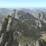
Yet another terrain mesh package of the European Alps? Well, this one is different in that it is NOT primarily based on the Shuttle Radar (SRTM) data with their incomplete coverage of prominent peaks and ridges. Instead, most of the source data for this project were developed over many months by Jonathan de Ferranti using detailed topographic maps. While Jonathan's work is unrelated to flight simulation he kindly gave me permission to compile his data for use in FS. The result is a wonderful improvement in detail and accuracy over any existing SRTM- or DTED-based mesh file, freeware or commercial (a link to an extensive set of screenshot comparisons is included in the read-me file).
I've compiled the source data at LOD10 (38-m) grid resolution because the coverage area is smaller than most existing mesh files. Thus, anyone can use these files without having to first uninstall their current mesh set. Also included are LOD9 and LO8 buffer mesh files. Note: if you own Austria Professional 2004 with its 1:50,000 scale terrain mesh then you don't need this package!
| Filename: | Alps_LOD10_Topo_Mesh__Austria_and_Italy.zip |
| License: | Freeware, limited distribution |
| Added: | 30th May 2010, 09:46:58 |
| Downloads: | 62,954 |
| Author: | Holger Sandmann, Jonathan de Ferranti |
| Size: | 73.32 MB |
| Category: Flight Simulator X - Aircraft Repaints, Textures and Modifications | |
| Consolidated PBY-5 TEAL ZK-AMP |
|
Images related to this file:
File Description:
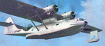
This folder contains a repaint for the Aerosoft PBY Catalina for FSX. Repaint by Jan Kees Blom, based on the repaint kit by Aerosoft. The Royal New Zealand Air Force had 56 Catalina's in all between 1943 and 1953. They were registered NZ4001-4056 inclusive and included 22 PBY-5s (mostly MklVAs) with the remainder being PB2B-1 s. All were flying boats, with no amphibian models being taken on charge.After the war only half a dozen or so of the best aircraft were maintained in service with No 5 Sqn (squadron code became KN-) and fitted with the latest search radar which had a large radome behind the cockpit. The remainder were put into storage. Two PB2B-ls were loaned to Tasman Empire Airways (TEAL) for short periods after the war, one (which became ZK-AMI) as a crew trainer, the other (ZK-AMP, former NZ4036) to survey a flying boat route from Fiji to Tahiti, later to become known as "The Coral Route" and used by TEAL's Solent flying boats. These two aircraft were eventually returned to the RNZAF before being scrapped.
| Filename: | Consolidated_PBY5_TEAL_ZKAMP.zip |
| License: | Freeware |
| Added: | 13th July 2018, 20:41:04 |
| Downloads: | 157 |
| Author: | Jan Kees Blom |
| Size: | 8.55 MB |
| Category: Flight Simulator 2004 - Scenery | |
| Kugluktuk CYCO in Nunavut, Canada |
|
Images related to this file:
File Description:
Kugluktuk is on the coast of northern mainland Canada on the mouth of the Coppermine River. It is around 250 miles west of Cambridge Bay and 200 miles south of Ulukhaktok. Tuktoyaktuk is 450 miles west. Kugluktuk used to be called Coppermine as copper was mined along the banks of the river and used for spear and arrow heads, and this attracted a semi-permanent population. The population now numbers around 1,450. The airfield is inland from the village and the 5,500 feet of 100 feet wide gravel runway is aligned 121T/3301T where T stands for "true" as opposed to magnetic in the Northern Domestic Airspace. Both JETA-1 and 100LL are available, dispensed by a truck as the storage tanks are just off the northern edge of the field. There are flights by First Air and Canadian North and the AI includes a daily flight of each, plus a cargo visit by Buffalo; the closest large city is Yellowknife, 375 miles south. I should have mentioned a long time ago that to see the apron lights working requires you to have the "lights_ss_v2" by Sidney Schwartz installed.
| Filename: | Kugluktuk_CYCO_in_Nunavut_Canada.zip |
| License: | Freeware |
| Added: | 10th November 2012, 04:03:35 |
| Downloads: | 429 |
| Author: | Roger Wensley |
| Size: | 3.04 MB |
| Category: Flight Simulator 2004 - Panels | |
| Generic Customized Advanced Panels |
|
File Description:
FS2004 Generic Advanced Customized Panels. Since this panel includes All XML gauges for 2-, 3- and 4 Jet engines aircrafts, Concorde and Warplains for 1 and 2 Engines, including landing panel. Special effects of the visor in the mainpanel of the Concorde. It can be used for any heavy jet. Also you have 3 choices, between the metal gray color panel (old Boeing) or the brown color of the FS2004 boeing default and the feeling to be in a Airbus (PFD of A380). All gauges are on the same place in the different engine version or airplane, no more memorizing the different panels. It has a full working overhead, TCAS radar, ATC control, customized FS2004 GPS, ACS-GPS, APU, FMC, HUD, Wiper and many custom xml gauges. Special attention is made on the Radio, Fuel, PFD, Clock, Taxi speed control, Wind speed, Bank rate, Auto mb-Hg, Push back,and Sim speed. A lot of information during take off, flight and landing. Many warnings included. Ideal panel for beginners and advanced simmers. Special Credit of gauges to Acsoft, Arne Bartels, Eric Mariano, Björn Karlsson, Tony d'Ambrosi, Nick Pike, etc. Panel design and gauges by Guy de Smet.
| Filename: | Generic_Customized_Advanced_Panels.zip |
| License: | Freeware |
| Added: | 16th January 2004, 23:00:39 |
| Downloads: | 16,068 |
| Author: | Guy De Smet |
| Size: | 10.3 MB |
| Category: Flight Simulator 2004 - Original Aircraft | |
| Mitsubishi F-2A (Beta Model, Version 2) |
|
Images related to this file:
File Description:

F-2A is a Japanese fighter aircraft and it has been developed with the United States based on the General Dynamics (post 1993, Lockheed Martin) F-16 Fighting Falcon. Its blue oceanic flight livery is referred to as "The most beautiful camouflage livery of the world". Its three divited canopy and big-wide wing is the most different part between the F-2 and F-16. This model is only for FS9, you can't use it with FSX. By Team FS KBT.
The Mitsubishi F-2 Fighter is manufactured by Mitsubishi Heavy Industries (MHI) and Lockheed Martin for the Japan Air Self-Defense Force, with a 60/40 split in manufacturing between Japan and the USA.
Some differences between the F-2 and the F-16A:
* a 25% larger wing area
* composite materials used to reduce overall weight and radar signature
* longer and wider nose to accommodate a phased-array radar
* larger tailplane
* larger air intake
* three-piece cockpit canopy
* capabilities for four ASM-1 or ASM-2 anti-ship missiles, four AAMs, and additional fuel tanks
| Filename: | Mitsubishi_F2A_Beta_Model_Version_2.zip |
| License: | Freeware |
| Added: | 3rd June 2010, 12:09:35 |
| Downloads: | 12,343 |
| Author: | Team FS KBT: Daisuke Yamamoto, Hiroaki Kubota, Shingo Katsumata with Friends |
| Size: | 72.93 MB |
| Category: Flight Simulator 2004 - Scenery | |
| Alaska South Slope 2 - Noorvik ORV in AK US |
|
Images related to this file:
File Description:
The town of Kotzebue is in the far northwest of Alaska, and these are villages to the north and the east of Kotzebue on the South Slope of the Brooks Range of mountains. There will be further additions. Noorvik is a small village (population now around 670) on the bank of the Kobuk River, around 50 miles east of Kotzebue. The new airfield is 1 mile south of the village; there is a short runway immediately south of the town that is now closed but is not marked as such and appears to be usable; this will still be listed in FS9 when you are presented with a choice of runways but is not connected in any way to the new airfield so ignore it. The new ORV runway has 4,000 feet of lit gravel aligned 06-24. There are scheduled flights by Era (now renamed Ravn) and by Bering Air, both of them originating in Kotzebue and routing east to Noorvik, Kiana, Ambler, Shungnak, Kobuk, and then back again. The AI includes these flights (eventually) plus perhaps an Everts Air cargo flight and GA.
| Filename: | Alaska_South_Slope_2__Noorvik_ORV_in_AK_US.zip |
| License: | Freeware, limited distribution |
| Added: | 4th September 2016, 18:20:02 |
| Downloads: | 221 |
| Author: | Roger Wensley |
| Size: | 3.95 MB |
| Category: Flight Simulator 2004 - Scenery | |
| Paulatuk CYPC in the Northwest Territories, Canada |
|
Images related to this file:
File Description:
Paulatuk is on the coast of northern mainland Canada, 200 miles east of Tuktoyaktuk and 170 miles southwest of Ulukhaktok. It is just to the east of the Parry Peninsula, which has at its northern tip the Cape Parry DEW line Main Station. Paulatuk was established in the 1920's, and the population now numbers around 320. Paulatuk airfield is close to the village but on higher ground, while the village follows the curve of the coast. The 4,000 feet of 100 feet wide gravel runway is aligned 021T/201T where T stands for "true" as opposed to magnetic in the Northern Domestic Airspace. Only JETA-1 is available unless there is 100LL in drums. There are flights by Aklak Air from Inuvik, which is around 250 miles to the west; Aklak Air is actually Kenn Borek under a diferent name. The AI is for a daily passenger flight, and for a cargo flight on Wednesdays. In the summer, float planes use the lake to the south of the village, but I have no information as to docks or any other facilities; probably there aren't any.
| Filename: | Paulatuk_CYPC_in_the_Northwest_Territories_Canada.zip |
| License: | Freeware, limited distribution |
| Added: | 3rd December 2012, 21:58:47 |
| Downloads: | 278 |
| Author: | Roger Wensley |
| Size: | 4.39 MB |
| Category: Flight Simulator X - Gauges | |
| Advanced Radar System 4 (ARS4) |
|
Images related to this file:
File Description:
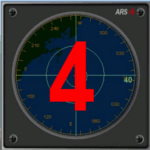
This gauge has been developed for FSX Flight Simulator SP1 or SP2. It
has also been tested with Microsoft Acceleration also, but compatibility is not guaranteed by the author.
This new Advanced Radar System (ARS 4) includes significant new features,
functions and displays for FSX AI traffic. The new key features are:
1)AI traffic display for air targets and boat/ship targets.
2)Auto landing on carrier if the carrier is part of the scenery MECOPS.
3)Allows switching between air target display and boat target display.
4) Provides for air and boat display to optionally insert airport and/or basic terrain display on the screen.
5)Different screen presentations for air and boat targets.
6)Simplified installation procedure.
7)The A2A re-fuel function remains the same as in the ARS2 version.
8)The auto tracking function remains the same as well as in the ARS2 version.
All displays for air, or boat/ship traffic, can be selected in a range of 5, 10, 20, and 40 miles.
For installation and additional information look at the ARS4 documentation inside the zip file. For copyrights and credits please look at the documentation for this gauge.
| Filename: | Advanced_Radar_System_4__ARS4.zip |
| License: | Freeware |
| Added: | 5th March 2013, 15:53:52 |
| Downloads: | 3,810 |
| Author: | Dietmar Loleit |
| Size: | 1.18 MB |
| Category: Flight Simulator X - AFCAD Files | |
| LQSA - Sarajevo Intl. Airport, Bosnia Herzegovina |
|
File Description:
Sarajevo International Airport (IATA: SJJ, ICAO: LQSA), also known as Butmir Airport, is the main international airport in Bosnia and Herzegovina, located 3.3 NM (6.1 km; 3.8 mi) southwest of the railway station in the capital city of Sarajevo in the suburb of Butmir. Since the Dayton Accord in 1996, the airport has welcomed a thriving commercial flight business which includes B&H Airlines, Austrian Airlines, Lufthansa, Jat Airways, Croatia Airlines, Turkish Airlines, Germanwings and others. In 2006, 466,186 passengers traveled through Sarajevo airport, compared to only 25,000 in 1996. In 2011 Sarajevo International Airport had 599,996 passengers which is more than all of the airports in Bosnia-Herzegovina had together and 6,5% more than in 2010. In 2012 the company has a slight decline in traffic. In 2005 the European branch of the Airports Council International awarded Sarajevo the award of Best Airport Under 1 Million Passengers. I just land in this airport, thank you to Sarajevo approach for a nice job. This file has the right coordinates, with runway 46 meters wide, apron and characteristics of the airport, airport vehicles and buildings.
| Filename: | LQSA__Sarajevo_Intl_Airport_Bosnia_Herzegovina.zip |
| License: | Freeware |
| Added: | 10th November 2012, 22:52:51 |
| Downloads: | 2,137 |
| Author: | Anwar Gonzalez |
| Size: | 4.44 MB |


© 2001-2026 AVSIM Online
All Rights Reserved
Privacy Policy |