
Where Flight Simulation Enthusiasts Gather from Around the World!
AVSIM Library - Search Results

| Category: Flight Simulator X - Gauges | |
| Advanced Radar System (ARS) |

|
Images related to this file:
File Description:
This Advanced Radar System (ARS) Version 1.0 displays AI traffic of FSX in a range of
5, 10, 20, and 40 miles.The ARS contains an AI tracking function, which allows you
to follow a selected AI automatically in terms of course and speed. In this mode
the ARS is coupled with the autopilot of your aircraft. The ARS feeds the
autopilot with the AI heading and speed data. The tracking mode can be
switched on or off.
An air fuel gauge is included in the ARS package also, which allows you to
perform an air re-fuel procedure for your aircraft. A air refueling can be done
from each AI aircraft if you have decided to use it as your tanker. The decision
will be done via a select function from the ARS panel and in addition via a
dedicated activation on the air fuel panel.For installation, look at the ARS_DOC folder.
(the folder is now included in the zip !!!!!!!!!! It was not in the previous upload. Sorry!)
COPYRIGHTS
This gauge is freeware. All rights are reserved and no part of the package may
be duplicated or distributed without the expressed, written permission of the
author.
CREDIT goes to: Bob Familton for his review of the documentation and testing
for SP1 FSX.
| Filename: | Advanced_Radar_System_ARS.zip |
| License: | Freeware |
| Added: | 2nd February 2011, 20:33:29 |
| Downloads: | 2,880 |
| Author: | Dietmar Loleit |
| Size: | 1.05 MB |
| Category: Flight Simulator 2004 - Original Aircraft | |
| Sukhoi Su-9 'Fishpot-B' |
|
File Description:
The Sukhoi Su-9 'Fishpot-B' was the Su-7's interceptor counterpart, serving exclusively with the Soviet IA-PVO (air defence force). The tailed delta Su-9 was generally similar in configuration to the MiG-21, though larger and heavier.
This aircraft was never exported outside the Soviet Union, and saw
active duty for only a comparitively brief period before other aircraft developments moved the Su-9 into second line service.
The Su-11 all-weather interceptor was a refinement of the Su-9 with a new engine, new radar and improved armament. The Sukhoi 'FISHPOT' was withdrawn from Soviet service around 1980.
The Su-9 prototype was the T-3 experimental aircraft that had its maiden flight on May 26, 1956. About 1,000 Su-9s and a number of training two-seaters were produced until 1962. The Su-9 was added into the Soviet Air Defence Service inventory in October 1960 and remained in service until the end of 1970s.
About 30 air regiments were armed with Su-9, including 3 regiments in the Moscow Air Defence Region.
The Su-9 took part in interceptions of ultra high flying USAF U-2 reconnaissance aircraft in the early 60's.
| Filename: | Sukhoi_Su9_FishpotB.zip |
| License: | Freeware |
| Added: | 8th September 2004, 18:43:30 |
| Downloads: | 4,782 |
| Author: | B.Hoskins |
| Size: | 9.47 MB |
| Category: Flight Simulator 2004 - Scenery | |
| North Manitoba Airfields 20# in Canada |
|
Images related to this file:
File Description:
These are 20 airfields in north Manitoba, Canada. They were all previously posted individually But not on Avsim. There is a screenshot of Google Earth showing their names and locations amid other airfields. "Lodge" indicates the fact that there is a fishing lodge and airfield at that location but that I have no information to enable me to make the scenery. There are also some airfields that I downloaded years ago and are part of my FS9 set up, such as Flin Flon. There is AI with the supply flights that are vital for these isolated outposts. Gillam is a northern airfield that is connected to the rest of Canada by a railroad that continues north to Churchill Manitoba on the Hudson Bay coast and is used for grain exports during the ice-free summer months. A large number of the supply flights originate from Gillam. You may wonder about the numbers of fuel tanks at these airfields. These are not for the airfield use, they are for the settlement to be able to generate electricity and also to provide heating in the winter. If you find an error email me please, and note that my email address has been changed to rogwens at Gmail dot com.
| Filename: | North_Manitoba_Airfields_20_in_Canada.zip |
| License: | Freeware, limited distribution |
| Added: | 7th April 2021, 17:09:34 |
| Downloads: | 82 |
| Author: | Roger Wensley |
| Size: | 35.99 MB |
| Category: Flight Simulator 2004 - Scenery | |
| Fort Liard CYJF in the Northwest Territories, Canada |
|
Images related to this file:
File Description:
Fort Liard is the seventh in a series of airfields that follow (approximately) the Mackenzie River. At the far northern end of the river there is Tuktoyaktuk, then Inuvik, Fort McPherson, Fort Good Hope, Deline, Wrigley, and then Fort Simpson Island and Fort Simpson, all posted. Fort Liard is at 708 feet asl and on the east bank of the the Liard River, around 130 miles south of Fort Simpson where the Liard and Mackenzie join, and about 25 miles from the borders with both British Columbia and the Yukon. The town has a population of about 560 folks.
The airport is next to the town, and has almost 3,000 feet of gravel runway. I have no information regarding when it was built but it may be from the WW2 time; the cleared and grassed area is long enough for a runway 0f 6,000 feet. There are no scheduled flights but North Cariboo Air have a base at the airport for local charters to support survey teams etc. and are almost an on-demand-scheduled airline. I have also added a Buffalo DC3 and GA. There is fuel available, but only by prior arrangement with North Cariboo. Right hand circuits for runway 20.
| Filename: | Fort_Liard_CYJF_in_the_Northwest_Territories_Canad.zip |
| License: | Freeware, limited distribution |
| Added: | 11th July 2014, 13:38:49 |
| Downloads: | 303 |
| Author: | Roger Wensley |
| Size: | 10.07 MB |
| Category: Flight Simulator 2004 - Scenery | |
| Cape Verde Islands Domestic Airports |
|
Images related to this file:
File Description:
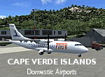
Googlyafcads and simple scenery for five airports in the Cape Verde Islands, all
of which are served by regular domestic flights of TACV - Transportes Aereos de
Cabo Verde. Each of these has been "overlooked" by Microsoft in Flight Simulator
2004 and are provided with nothing other than a runway. These scenery files add
aprons, taxiways, buildings and other airport features to Flight Simulator's bland
representation and allow you and "AI" traffic to land, taxi, park and take off
in a realistic manner.
The airports represented are: GVBA Rabil, GVMA Maio, GVSF Sao Filipe, GVSN Preguica and GVSV Sao Pedro.
The scenery does not purport to be ultra-accurate. Based on high-detail satellite
imagery from Google Earth (except Sao Filipe), the layout is proportianally correct
but the added airport features, such as buildings, are built from default Microsoft
objects and add-on libraries so will not look like the real thing. Sao Filipe is
largely imaginary owing to poor quality of the satellite image, but has been created
to be similar to other airports of like size.
You are not obliged to download and install any additional scenery libraries,
but to enjoy this scenery in its entirety, you may wish to. It will work fine,
with or without.
[File re-uploaded at request of AVSIM]
| Filename: | Cape_Verde_Islands_Domestic_Airports.zip |
| License: | Freeware |
| Added: | 15th June 2010, 01:00:46 |
| Downloads: | 6,997 |
| Author: | John Hinson |
| Size: | 84.1 KB |
| Category: Flight Simulator X - Aircraft Repaints, Textures and Modifications | |
| Supermarine Spitfire IX ML214 126 Sqn 5J-K |
|
Images related to this file:
File Description:
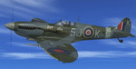
This folder contains a repaint for the Supermarine Spitfire Mk.IX by Real Air. It shows Spitfire IXc ML214 5J-K as flown by Squadron Leader Ioannis Agorastos "John" Plagis of RAF 126 (Persian Gulf) Squadron, based in RAF Culmhead, may 1944. S/L Plagis was born in Rhodesia of Greek parents and was officially listed as a Greek pilot with the RAF. He enlisted in october 1940, and was trained in the UK before being sent to the Mediterranean. He flew a Spitfire off HMS Eagle to Malta, where he soon became the first Spitfire ace with 249 squadron. His final score on Malta was 10, keeping a vow he made when a friend of his was shot down by the Germans. He returned to the UK in august 1942 and spent a year as an instructor. He returned to active duty in september 1943 as CO of 64 squadron, and joined No 126 squadron in january 1944. He picked ML214 as his personal aircraft because of the K on the tail, since all his aircraft were always named after his sister Kay. He ended the war flying Mustangs, with an official score of 16 aircraft and two probables, making him the highest ranking Rhodesian and Greek pilot. Repaint by Jan Kees Blom, based on the paintkit by RealAir.
| Filename: | Supermarine_Spitfire_IX_ML214_126_Sqn_5JK.zip |
| License: | Freeware |
| Added: | 11th July 2018, 16:49:32 |
| Downloads: | 68 |
| Author: | Jan Kees Blom |
| Size: | 4.13 MB |
| Category: Flight Simulator 2004 - AFCAD Files | |
| Connellan Airports |
|
File Description:
Connellan Airways was formed in 1939 (known as Survey & Inland Transport until 1943) and the 1967 schedules show 114 airports and airstrips served by the airline across Northern Territory of Australia and reaching out into Western Australia, South Australia and Queensland too (including two named Springvale many miles apart!). It operated until 1980 when it was sold to East West Airlines. The airport at Ayers Rock, once their headquarters, has been named after the airline.
Of those 114 airports and airstrips, very few appear in Flight Simulator or in any add-on I have come across. This package seeks to redress the situation with 81 new A&FD files, representing new airports plus a couple of default ones enhanced with parking spots. Most of the airstrips remain in use today serving remote cattle stations and townships but satellite data shows a few to now be overgrown and out of use. A few cannot be traced owing to poor quality satellite imagery and have had to be omitted here.
All files are based on satellite data including altitude, and therefore work best with a high quality mesh add-on - they will still work with the default landscape of Flight Simulator but some airstrips may look a little high or low compared with the surroundling area.
| Filename: | Connellan_Airports.zip |
| License: | Freeware |
| Added: | 16th June 2015, 14:45:11 |
| Downloads: | 126 |
| Author: | John Hinson |
| Size: | 155.17 KB |
| Category: Flight Simulator 2004 - Scenery | |
| EPMO - Modlin 2009 |
|
Images related to this file:
File Description:

EPMO MODLIN 2009 features an extremely detailed scenery of military airfield near Warsaw, Poland, fully compatible with FS2004. In the past it was a payware scenery, but Drzewiecki Design decided to provide you that old full product for FREE!
The airport was upgraded around 2012 and currently it has a nice passenger terminal and serves low-cost carriers like Ryanair, however back in 2009 it was an almost abandoned military airfield with some amazing structures inside. This scenery shows the status of Modlin airport in 2009 having many tumble-down buildings, deformed and rusty metal stairs and much more. Nothing has left of that old airport by now but using our scenery you can go back in time and check for yourself how it looked like.
The scenery features accurate positioning, modelling and texturing, high quality photoreal textures of all airport buildings (some buildings include interior) and high quality aerial photos of the airport. The package also includes charts and airfield specification.
The product is equipped with an automatic installer, but you need to manually add the airport into the Flight Simulator Scenery Library (see attached manual or read my text below). Please uninstall all previous versions of this airport you may have installed before. Please make also sure that no duplicate AFCAD files are installed.
Enjoy your virtual flying with Drzewiecki Design!
| Filename: | EPMO__Modlin_2009.zip |
| License: | Freeware, limited distribution |
| Added: | 2nd September 2015, 21:54:41 |
| Downloads: | 402 |
| Author: | Drzewiecki Design |
| Size: | 132.96 MB |
| Category: Flight Simulator 2004 - AI Aircraft | |
| United Express Air Wisconsin OC BAe 146-100 N463AP |
|
Images related to this file:
File Description:

United Express Air Wisconsin OC FMAI BAe 146-100 N463AP //
Air Wisconsin Airlines Corporation is an airline based at Outagamie County Regional Airport in the town of Greenville, Wisconsin, United States, near Appleton. Air Wisconsin is the largest privately held regional airline in the United States. It operates regional jet flights as US Airways Express under contract to US Airways, serving 69 cities in the US and Canada with hubs at Philadelphia International Airport and Ronald Reagan Washington National Airport. The airline is also a ground-handler for United Express at over 30 locations. Source Wiki. //
Flightplans may be available on AVSIM/Flightsim.com.
This works for both FS9 and FSX. Tested in FSX. FS9 model used.
For FSX users make sure you have UNCHECKED "Aircraft casts shadows on the ground" under the Aircraft - Exterior Settings in FSX to make any FS9-based model visible during the day!
Texture quality; FSX Native: DDS DXT5 with alpha. FS9 Native: BMP DXT3 with alpha.
FSX Light Fix included in the DDS night texture.
Custom Light Map. Custom Shadows, Highs, Weathering as usual...
Included repaint is for the following model; BAe 146-100 from FMAI
Model is available on AVSIM, FlightSim.com or on the author/developers site.
You need the basekit for this to work!!
Do make sure you copy the texture folder(s) in the respective folder.
| Filename: | United_Express_Air_Wisconsin_OC_BAe_146100_N463AP.zip |
| License: | Freeware, limited distribution |
| Added: | 5th August 2012, 13:45:16 |
| Downloads: | 398 |
| Author: | Stephan Faessler / ImpulseAI |
| Size: | 1.55 MB |
| Category: Flight Simulator X - Scenery | |
| YCDN Corunna Downs Station and Old Corunna Downs RAAF (Closed) |
|
File Description:
Corunna Downs heritage listed RAAF Base was a secret airfield located in scrub and spinifex country, about 16 kms south west of Marble Bar, the hottest part of the "The Pilbara" area of Western Australia. Not a very ideal place to have a tent city. Today there are very few reminders of the once busy airfield. One can see some crumbling foundations and half filled post holes. 73 OBU operated the Corunna Downs airfield which comprised two intersecting bitumen runways, now regressed and graded occasionally. One ran approximately north-south, 5,000 feet in length while the other ran approximately east-west, 7,000 feet in length. Both runways were approximately 150 feet wide. A 50 foot wide taxiway linked the northern end of the north-south runway to the western end of the east-west runway. Approximately 20 camouflaged revetments to disperse aircraft to minimise bomb damage were constructed at Corunna Downs. Permission is required for landing and there may be vegetation on the strip if not graded recently. No cones or windsock so be careful. Corunna Downs Homestead is also heritage listed and consists of graded strips and homestead complex. Start points are at the homestead and the RAAF base is to the west. REQUIRES Blencowe_LibraryKit.zip
REQUIRES blencowe_librarykit_309494.zip (Available HERE)
| Filename: | YCDN_Corunna_Downs_Station_and_Old_Corunna_Downs_R.zip |
| License: | Freeware |
| Added: | 25th February 2013, 08:59:42 |
| Downloads: | 281 |
| Author: | Alan Blencowe |
| Size: | 4.92 MB |


© 2001-2026 AVSIM Online
All Rights Reserved
Privacy Policy |