
Where Flight Simulation Enthusiasts Gather from Around the World!
AVSIM Library - Search Results

| Category: Flight Simulator 2004 - Scenery | |
| Whati CEM3 in the Northwest Territories, Canada |

|
Images related to this file:
File Description:
Whati is a village at the southern end of Lac La Martre, a smaller lake (only by Canadian standards, at over 40 miles long) halfway between the Great Slave Lake and the Great Bear Lake and around 100 miles north of Yellowknife. The North West Company established a trading post there in 1793, and this was the centre for local trading in the area for 100 years until a post was opened by the Hudson Bay Company on the Great Slave Lake. The current population is in the region of 520. There is no graded road access and access is by boat or air. The main local economy revolves around hunting and fishing, with efforts being made to increase tourism amid the wilderness and the wildlife. The airfield is just over a mile east of the village, with a runway of around 3,400 feet of gravel aligned 09-27 as of 2010, with PAPI at both ends and lit. There are scheduled flights from Yellowknife by Air Tindi, included in the AI, and some GA. The terminal building is similar to that of Lutselk'e, but with a different colour scheme and with solar panels on the roof. It appears that they repaint the sign on the front of the building with a different wording every time; the one I have used is one of three that have existed in the last few years. The photos I had originally were taken in the winter, with snow. Seeing it in the summer I discovered that my version of the building is not at the right level above the ground by about a foot, or 30cm. I was too lazy to make it again, which was the only way to get it right and still have it throw a shadow on the ground. This scenery modifies the lake shore, corrects levels for land and lake, and adds the village and a connecting road in addition to the airport. A note here about my scenery making. There will not be many more to follow this as I am almost at the end of the photos I either took or found for scenery purposes, plus I expect to move on from FS9 at some point during next year.
| Filename: | Whati_CEM3_in_the_Northwest_Territories_Canada.zip |
| License: | Freeware, limited distribution |
| Added: | 15th December 2019, 19:18:29 |
| Downloads: | 149 |
| Author: | Roger Wensley |
| Size: | 4.25 MB |
| Category: Flight Simulator 2004 - Scenery | |
| Quesnel CYQZ in British Columbia, Canada |
|
File Description:
Quesnel is around 65 miles south of Prince George, at the junction of the Fraser and Quesnel Rivers. It has a population of less than 10,000 and is reliant on the timber industry and tourism (hiking, canoeing, fishing, hunting) in the surrounding area for it's income. The date for this scenery is, once again, around 2010. The airport is on the northern edge of the town and has a runway of 5,500 feet aligned 13-31 with PAPI at both ends. Because of the surrounding terrain runway 13 has a right hand VFR circuit. Parking for GA aircraft is organised by the Quesnel Flying Club in a grassed area adjacent to the concrete and asphalt apron. Also adjacent to the apron is the extraordinary terminal building, and next to that is the comparatively very ordinary building that houses the flying club. There are the usual airfield and plane maintenance buildings, and at the southern end of the runway two private hangars. There is also a Fire Base housing personnel that either drive from the base or fly by helicopter to deal with local forest fires at ground level. The AI included here is for Central Mountain Air and GA. I added to and adjusted the CYXS AI so that there are GA flights between CYXS and CYQZ, so just replace your current CYXS AI with this new one. Please email me if you find faults, such as a plane without textures. Note my newish email address at the end of these notes.
| Filename: | Quesnel_CYQZ_in_British_Columbia_Canada.zip |
| License: | Freeware, limited distribution |
| Added: | 19th December 2022, 19:27:14 |
| Downloads: | 147 |
| Author: | Roger Wensley |
| Size: | 9.49 MB |
| Category: Flight Simulator X - Scenery | |
| LYBE Belgrade Nikola Tesla Airport |
|
File Description:
Belgrade Nikola Tesla Airport (IATA: BEG, ICAO: LYBE) is the primary international airport serving Belgrade, Serbia. Previously known as Belgrade International Airport, it was renamed in 2006 in honour of Serbian-American scientist and
inventor Nikola Tesla.
The airport is situated 12 km (7.5 mi) west, of central Belgrade, in the Surcin Municipality, surrounded by Syrmia's fertile lowlands. Passengers on the right hand side of planes descending from the east have a view of downtown
Belgrade, especially the districts of Cukarica and Novi Beograd. In 2008 the airport installed ILS CAT IIIb equipment to allow aircraft to land and depart in the heaviest of fog, which in past years led to numerous flight diversions
mostly in late December and early January.
The airport is owned and operated by the Public enterprise Aerodrom Nikola Tesla Beograd��. The company recorded profit of 21.5 million euros at the end of 2010.
The national flag carrier and largest airline of Serbia, Jat Airways, uses Belgrade Nikola Tesla as their main hub. It is also one of the hubs for low cost airline Wizz Air. Aviogenex charter airline, and air taxi airlines Air Pink,
Jat Airways AVIO taxi, Prince Aviation and Pelikan Airways also call the airport their home.
The airport charts are included.
This file has the right coordenates, with the apron and characteristics of the airport, airport vehicules and buildings, please take note the the gates numbers needed to changed: C1A= C11, C3A=C13, C5A=C15; general aviation parking
were added a extra number due to repetion on the numbers.
| Filename: | LYBE_Belgrade_Nikola_Tesla_Airport.zip |
| License: | Freeware |
| Added: | 8th November 2012, 03:32:04 |
| Downloads: | 8,817 |
| Author: | Anwar Gonzalez |
| Size: | 15.17 MB |
| Category: Prepar3D V1-4 - Aircraft Repaints, Textures and Modifications | |
| Douglas C-47 French Navy (36) |
|
Images related to this file:
File Description:
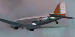
This folder contains a repaint for P3Dv4.5 PBR version of the Douglas C-47 by Manfred Jahn and colleagues in the colors of C-47 #36 of the French Navy (Aeronavale). Originally c/n9798 42-23936 it flew with the USAAF in North Africa and later in the ETO. It took part in D-Day, Market Garden and Operation Varsity, dropping parachutists. After WW2 it went to Ceskoslovenske Aeroline as OK-WDU and between 1958 and 1983 with the French navy as #36. It later went to Stellair and Transvalair in France as F-GEOM, before going to the UK as G-OFON with Classic Airways and later Air Atlantique. After a stint with South Coast Airways, it went to the Aviodrome in the Netherlands in 2006, where unfortunately it was left outside without protection. When the Aviodrome went bankrupt it went to Classic Wings, who are currently restoring it for static display in the Museum in Overloon. Repaint by Jan Kees Blom for Manfred Jahn's C-47 for P3Dv4.5, with PBR, Rivet and bump detail by Ted (Tufun) Wolfgang."
| Filename: | Douglas_C47_French_Navy_36.zip |
| License: | Freeware |
| Added: | 29th January 2020, 01:04:47 |
| Downloads: | 323 |
| Author: | Jan Kees Blom |
| Size: | 42.29 MB |
| Category: Flight Simulator X - Aircraft Repaints, Textures and Modifications | |
| Fiji Airways Boeing 777-200ER (GE) (DQ-FJT) |
|
Images related to this file:
File Description:

This is a repaint of a Boeing 777-200ER, registration code DQ-FJT, operated by Fiji Airways, the flag carrier airline of Fiji. It operates international and domestic services to 10 countries and 15 cities around the Pacific, including Australia and New Zealand, North America and Hong Kong. While Fiji Airways currently does not operate any Boeing 777-200ERs, they did lease and operate one in 2012.
This repaint has plenty of clear markings so if you enjoy exterior detail, then you will love this repaint. You can see (and read): Door opening instructions; Static port directions; Air vent warnings; Engine hazard area; No Step warnings; RAT caution; APU intake warning; Stabilizer compartment access; Ground power supply; Forward and aft access door instructions; Pitot, ADA probe, Ice detector and TAT probe markings; Visible rivets; Enhanced window frames; Authentic Fiji logo; Bold, colorful Fiji livery and authentic flags; Lovely Fiji flight attendant; No frame rate hit.
To use this repaint, the Captain Sim B777-200 exterior model is required.
| Filename: | Fiji_Airways__Boeing_777200ER_GE_DQFJT.zip |
| License: | Freeware |
| Added: | 6th March 2014, 00:28:59 |
| Downloads: | 767 |
| Author: | Garrett Rowley, Captain Sim |
| Size: | 28.66 MB |
| Category: Prepar3D V1-4 - Scenery | |
| Valdez Alaska USA N61.06.53 W146.19.52 and Tatitlek Alaska USA N6052.00 W146.41.37 |
|
File Description:
Valdez Alaska USA N61.06.53 W146.19.52 The town is positioned at the head of a fjord on the eastern side of the Prince William Strait (at the end of the Valdez bay). It is surrounded by the Chugach mountains with many glaciers and peaks up to 2100 m above sea level. Although the northernmost port in North America is free of ice all year round. It is also the northernmost point of the Pacific coastal forest located in the 107-meter hill southwest of the town called Blueberry Hill. Valdez has an ICAO PAVD airport that in the scenario in addition to the city of Valdez you will also find a small village called Tatitlek Alaska USA N6052.00 W146.41.37 with related ICAO 7KA airport airports infrastructures have been improved with the addition of a port for landing ships and seaplanes on Valdez and Tatitlek. Important VFR point for approaching airport and seairport PAVD and 7KA.
Within the downloaded package you will find readme files for scenery installation. Good fly VFR. Pasquale Marrulli.
| Filename: | Valdez_Alaska_USA_N610653_W1461952_and_Tatitlek_Al.zip |
| License: | Freeware |
| Added: | 21st May 2018, 22:35:56 |
| Downloads: | 230 |
| Author: | Pasquale Marrulli |
| Size: | 3.27 MB |
| Category: Flight Simulator X - Scenery | |
| RAF Shepherds Grove - Suffolk, England |
|
File Description:
RAF Shepherds Grove is a former Royal Air Force station located 9.9 miles (15.9 km) north-east of Bury St Edmunds, Suffolk, England.
The Station was originally built for the United States Army Air Forces (USAAF) Eighth Air Force during the Second World War. However the facility was not used by the USAAF and was opened by No. 3 Group RAF on 3 April 1944. The name came from a small copse nearby and the airfield is close to Walsham le Willows in Suffolk.
It was occupied by No. 196 Squadron RAF in January 1945 as a base for Operation Varsity, supporting the Rhine crossing.
Various American units occupied the station after WW2 but ended their use of the unit in December 1958.
On 22 July 1956, No. 82 Squadron RAF was activated at Shepherds Grove as a Thor missile unit. Thor launching sites were built on the main airfield and became operational in 1959.
The base was closed in 1966. Third party files are required - see the readme.txt for details.
| Filename: | RAF_Shepherds_Grove__Suffolk_England.zip |
| License: | Freeware |
| Added: | 4th December 2015, 09:34:13 |
| Downloads: | 159 |
| Author: | Terry Boissel |
| Size: | 13.26 KB |
| Category: Flight Simulator 2004 - AFCAD Files | |
| Newark Liberty Int'l Airport (KEWR) with active Crosswind Runway |
|
Images related to this file:
File Description:
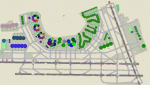
A high spec AFCAD2 for the FS2004 Newark Liberty Int'l Airport (KEWR) scenery by Steve Whalin. This afcad has been built using FAA Charts and information from the Airport Website. All taxiways are named and all aprons are reworked to be as real as possible according to photos. All gates are named as per real life and have airlines assigned to them. The Fedex and UPS aprons are represented and can accomodate many cargo aircraft. The final addition is random GA parking and the CO maintenance area to the north of the airport. Overflow parking is also available for rush hour periods (Ball Park). This airport features a tower view and also night and approach lighting. Finally, by using the crosswind runway technique, runways 04L/22R, 04R/22L and 11/29 can all be used simultaniously for take-off and landing. Runway 11/29 will be mainly used by CO Express flights. Enjoy!!
This afcad works with the Steve Whalin scenery only (Requires: kewr.zip).
| Filename: | Newark_Liberty_Intl_Airport_KEWR_with_active_Cross.zip |
| License: | Freeware |
| Added: | 2nd March 2010, 19:26:13 |
| Downloads: | 1,355 |
| Author: | Lee Brompton |
| Size: | 259.8 KB |
| Category: Flight Simulator X - AFCAD Files | |
| LYUZ - Ponikve airport - Uzice, Serbia |
|
File Description:
Uzice Ponikve Airport (Serbian: Aerodrom Uzice Ponikve) (IATA: UZC, ICAO: LYUZ); also known as Lepa Glava (literally: Beautiful Head) is an airport in the western part of Serbia. The airport is located at Ponikve (literally: Sinkholes) plateau: 8 km (5 mi) southwest from the Jelova Gora, 11 km (7 mi) east from the Mount Tara, 12 km (7.5 mi) northwest from the city of Uzice, 13 km (8 mi) southeast from the town of Bajina Basta, 19 km (12 mi) northeast from the popular tourist center with unique attractions of the Mokra Gora, 20 km (12.5 mi) north from the Mount Zlatibor, 20 km (12.5 mi) southwest from the town of Kosjeric, 27 km (17 mi) northwest from the town of Pozega, 32 km (20 mi) southwest from the Mountain resort Divcibare, 35 km (22 mi) northeast from the town of Visegrad in Republic of Srpska (BiH), 50 km (31 mi) northwest from the Mount Zlatar. The airport is partially reconstructed in order to become an international airport. Charts included
| Filename: | LYUZ__Ponikve_airport__Uzice_Serbia.zip |
| License: | Freeware |
| Added: | 18th August 2016, 03:56:56 |
| Downloads: | 245 |
| Author: | Danilo Jankovic |
| Size: | 3.56 MB |
| Category: Flight Simulator 2004 - Aircraft Repaints, Textures and Modifications | |
| Syrian Air Airbus A320-232 (YK-AKE) |
|
Images related to this file:
File Description:

Syrian Arab Airlines, operating as SyrianAir, is the flag carrier airline of Syria. It operates scheduled international services to several destinations in Asia, Europe and North Africa, the number of flights operated has seriously declined due to the turmoil in Syria. SyrianAir used to serve over 50 destinations worldwide in recent years. Its main base is Damascus International Airport and Aleppo International Airport. SyrianAir is a member of the Arab Air Carriers Organization and Arabesk Airline Alliance.
Syrian Air's livery is painted on Project Airbus's Airbus A320-232 aircraft (included). The textures are saved in 32bit format for quality graphics. Textures are also characterized by HD (High Definition). Its features are idle-reverser animation, animated pack vents and pressurisation outflow valve, detailed textures, accurate paint, dynamic shine & effects, dynamic flexing wings that respond to turbulence, fully independent suspension, trim animation, gear steering, accurate flight dynamics, spoiler animation, reflective cockpit windows, improved wingflex code with input from several new parameters including ground spoilers, fuel load, and angle of attack, transparent navigation light lenses and many more. Thanks for downloading & Happy flying.
| Filename: | Syrian_Air_Airbus_A320232_YKAKE.zip |
| License: | Freeware |
| Added: | 7th July 2013, 19:18:03 |
| Downloads: | 802 |
| Author: | Giacomo Tomasini |
| Size: | 16.47 MB |


© 2001-2026 AVSIM Online
All Rights Reserved
Privacy Policy |