
Where Flight Simulation Enthusiasts Gather from Around the World!
AVSIM Library - Search Results

| Category: Flight Simulator 2004 - Scenery | |
| Gananoque CNN8 in Ontario, Canada |

|
Images related to this file:
File Description:
Gananoque is an ex-RCAF airfield 20 miles east of Kingston and Lake Ontario and 5 miles north of the Thousand Islands area of the St. Lawrence River and the US border. The airfield was a relief landing field for Kingston during WW2 and opened in 1940 with the classic triangle of runways. It closed in 1945 and is now a sky diving centre, still with the original single hangar and control tower. Fuel is no longer sold there so the only reason to pass by is as part of a visit to the Thousand Islands area, or perhaps look at the Canso (Canadian name for the PBY Catalina) which I understand is in the hangar. Unfortunately, when I turned up there was nobody there. The runways and the taxiways and the apron are all still usable but in what can only be called a state of random disrepair. Centre lines and signage are luxuries. I have included a photo with runway headings indicated.
| Filename: | Gananoque_CNN8_in_Ontario_Canada.zip |
| License: | Freeware, limited distribution |
| Added: | 22nd March 2012, 17:27:11 |
| Downloads: | 286 |
| Author: | Roger Wensley |
| Size: | 3.2 MB |
| Category: Flight Simulator 2004 - Scenery | |
| CYEG Edmonton International |
|
File Description:
Re-upload. Based on aerial and ground photos. The main terminal and cargo area buildings were all replaced. The aprons were modified to be more accurate and the smaller cargo area taxiway was added. All the usual goodies are included. V2 is a complete replacement for V1. Due to a nasty bug in EZ-Scenery (since eradicated), the entire V1 scenery was misaligned. That has been fixed. Incorrectly sized objects on the cargo ramps have been fixed. The commuter airline parking at the north side of the main terminal has been corrected to make it more like the real thing. V1.1, which contained just the ramp lighting, has been incorporated into V2.
One significant change is that there are now two versions of the scenery, V2 and V2a. V2, like V1, has static aircraft parked at the cargo ramps. In V2a the static aircraft have been removed so ai cargo planes can park at the cargo ramps. V2a of the AFCAD file has cargo parking spaces added.
| Filename: | CYEG_Edmonton_International.zip |
| License: | Freeware |
| Added: | 21st June 2010, 11:09:00 |
| Downloads: | 12,723 |
| Author: | Sidney Schwartz |
| Size: | 2.49 MB |
| Category: Prepar3D V1-4 - Aircraft Repaints, Textures and Modifications | |
| Air Austral 1998 AI Package |
|
File Description:
Air Austral had yet to venture into longhaul flying in 1998, with 2 737-300s and a 737-500 flying to neighboring islands and venturing a bit into Western and Southern Africa. As the Comoros and Mayotte didn't have flag carriers, Air Austral and Air Madagascar connected destinations to these islands beyond RUN. Note that the YVA airport has since closed and the HAH airport further north is used now. These plans use the old airport and a scenery will eventually be created. Today, the airline has grown many times it's size in 1998 and now flies 777-300ERs and 787s across the globe.
Repaints for the FAIB 737-300 and 737-500 by APG and Alex\Funk included. Flightplans by Chasen Richardson. Part of the 1998 Flight Simulator Project. Follow us on Facebook at facebook.com/flightsim98 and on instagram as @bayviationsim. For more Retro AI, check out the forums at: http://retroai.proboards.com/
| Filename: | Air_Austral_1998_AI_Package.zip |
| License: | Freeware, limited distribution |
| Added: | 28th December 2019, 19:53:40 |
| Downloads: | 157 |
| Author: | Antoine Calleja, Alex\Funk,Chasen Richardson\Bayviation |
| Size: | 1.16 MB |
| Category: Flight Simulator 2004 - Scenery | |
| World Trade Center Twin Towers (Textures Only) |
|
Images related to this file:
File Description:
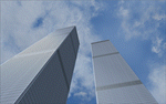
World Trade Center Twin Towers Textures - Only for Use With Tatu Kantomaa's New York City Objects.
These are Textures Only!
You must either have Tatu Kantomaa's New York City Objects scenery installed or you must download and install His scenery to use my textures (full details on file location in readme).
This is my way of rebuilding the Twin Towers and now they can Live again within the World of Flight Simulation.
Special Thanks To Tatu Kantomaa for granting me permission to upload these WTC texture modifications for use with His Great scenery "New York City Objects". His excellent scenery really improves NYC in FS9 with many other buildings created at a very high level of quality. Both North and South Tower Helipads are landable. You will find the Towers Glow with the color of the sunset so Dusk flights are very special when combined with My custom WTC night lighting. Please see Read Me file for more important information.
| Filename: | World_Trade_Center_Twin_Towers_Textures_Only.zip |
| License: | Freeware |
| Added: | 10th September 2011, 18:19:53 |
| Downloads: | 2,271 |
| Author: | Todd Manbeck,Tatu Kantomaa |
| Size: | 7.86 MB |
| Category: Flight Simulator 2004 - Scenery | |
| Quaqtaq CYHA in Hudson Strait, Quebec, Canada |
|
Images related to this file:
File Description:
Quaqtaq is a small village of 310 or so inhabitants at N 61 W 69 37 on the Hudson Strait at the northwest corner of Ungava Bay. It's name has some connection with "tapeworm" in Inuit; there is a story but I won't recount it here. The village does not feature in FS9 but is included in this scenery with approximately the right shape. No village buildings were specifically modeled; they are hand-made non-specific village houses typical of the north. The airfield runway is 3,520 feet of gravel 100 feet wide and is at 103 feet above the shoreline. I added the roads, a new airfield background, plus of course there is the scenery file and the AFCAD and AI, which is an Air Inuit Dash 8-300. This is the last of a series in northern Quebec that all have similar terminal buildings; I know of others which have the same type of building but I have no photos to discover the differences.
| Filename: | Quaqtaq_CYHA_in_Hudson_Strait_Quebec_Canada.zip |
| License: | Freeware, limited distribution |
| Added: | 8th November 2010, 04:29:39 |
| Downloads: | 414 |
| Author: | Roger Wensley |
| Size: | 2 MB |
| Category: Flight Simulator 2002 - Scenery | |
| Palisades SRTM Altitude Mesh |
|
File Description:
Ever wanted to fly down the VFR corridor over the Hudson River and gawk at all the skyscrapers in New York City? ... in your dreams! The Department of Fatherland Security has closed it down.
But, we still have Flight Simulator. Unfortunately, the altitude mesh for this area is somewhat lacking in detail.
This Palisades altitude mesh remedies that. Covers the Palisades cliffs, of course (but no Amusement Park, sniff), and also Riverside, Morningside, and Washington Heights, and Fort Tryon. In fact, all 5 Boroughs of New York City are covered, as well as most of central and northern New Jersey (visit beautiful downtown Hoboken!), and the larger part of Long Island. Also Rockland, Westchester, Orange, Putnam counties and more. And even Bear Mountain State Park.
Approximate coverage: N40* to N42* and W73* to W75*.
Made from NASA Shuttle Radar Topography Mission data (3 arc-second resampled to LOD9 - horizontal resolution of 76.4 meters) using SRTM to BGL by Matthew Styles (available in the AvSim library.) Very easy to use - give it a try.
BONUS: includes simple instructions so that anyone can make altitude mesh for their area from SRTM data using SRTM to BGL by Matthew Styles. Sorry, SRTM data only available for the Americas at the moment. The rest of the world coming soon. Check inside for more details.
No support of any kind is offered for this package - very sorry.
| Filename: | Palisades_SRTM_Altitude_Mesh.zip |
| License: | Freeware |
| Added: | 12th June 2003, 16:09:26 |
| Downloads: | 2,165 |
| Author: | Luis, scenery design forum |
| Size: | 3.48 MB |
| Category: Flight Simulator X - Scenery | |
| Eagle Field - Port Matilda, PA |
|
Images related to this file:
File Description:
Eagle field- 09PA Port Matilda PA.
Private Glider field Owned by Karl Striedieck. Karl is a world record setting glider pilot and a member of the U.S. Soaring Hall of Fame. He was an early pioneer of ridge soaring in the Ridge-and-valley Appalachians in the 1960s, ultimately setting nine world records flying gliders there. He was selected for the U.S. national soaring team 12 times, and won a silver medal in the world championships in 1978 and 1983.
Mr. Striedieck was a U.S. Air Force pilot from 1959 to 1962, flying the F-86 Sabre and F-102 Delta Dagger, then continued his military service until 1981 in the Pennsylvania Air National Guard, where he transitioned to the A-7 Corsair II. A year before graduating from Pennsylvania State University in 1965, he started flying gliders when he and Bill Clark co-founded the Nittany Soaring Club, flying out of the former State College Air Depot. He has over 15,000 flying hours, with nearly half of that total in gliders.
Mr. Striedieck moved his home to the Eagle Field private airport on top of Bald Eagle Mountain, near State College, Pennsylvania in 1966, and now lives there with his second wife, Iris.
Basically a manicured farm field, this private glider field offers access to the famous ridge lift of central Pennsylvania.Nearby Ridge Soaring is another one of my airfields available.
| Filename: | Eagle_Field__Port_Matilda_PA.zip |
| License: | Freeware |
| Added: | 11th June 2014, 16:30:28 |
| Downloads: | 323 |
| Author: | Jon Davidson |
| Size: | 16.52 MB |
| Category: Flight Simulator 2004 - Scenery | |
| RAF Wittering 1990 |
|
Images related to this file:
File Description:

Wittering was opened as an RAF station in 1924, but flying here started way back in 1916 with the Royal Flying Corps.
Initially the Central Flying School was based here from 1926 until 1935. During World War 2, Wittering was a part of 12 Group, which was responsible for the defence of the Midlands.
The station took on a nuclear responsibility in 1956 with the arrival of the V-Force Valiants, and later Victor bombers. Because of this, the runway was increased in length.
After the V-Bombers left, the station took on the mantle of Home of the Harrier, a title it carried with it from 1969, until the stations closure in 2010.
This scenery is made up of various library objects, using ScruffyDuck's ADE9X, to make a close representation of the base, as opposed to being factually accurate.
Brian has incorporated most of the extra runways and representations of deck landing areas that were used at Wittering for V/STOL training - these runways are not active, but may still obviously be used for taking off and landing yourself.
Also included are repaints of John Young's Harrier GR3/T4 AI model, available from flightsim.com. These represent the aircraft of No.1(F) Squadron and No.233 OCU, during 1989-90.
There are also a set of representative flightplans to allow the Harriers to fly "typical" missions and flights.
| Filename: | RAF_Wittering_1990.zip |
| License: | Freeware, limited distribution |
| Added: | 6th October 2013, 17:17:42 |
| Downloads: | 1,392 |
| Author: | Brian Clarke, Daryl Payne |
| Size: | 20.58 MB |
| Category: Flight Simulator 2004 - AFCAD Files | |
| La Guardia |
|
File Description:
A high quality AFCAD2 file the New York La Guardia (KLGA) scenery by Shehryar Ansari. This file features assigned gates for all airlines that currently serve LGA. In order to ensure only 'mainline' aircraft use the jetbridges, a new 'Express' apron for Dash 8 and RJ size aircraft is provided near the Central Terminal and also adjacent to the US Air and Delta Terminals. An extensive GA parking area has also been added to the west side of the airport and includes 4 Helipads. A tower view is provided for the airport and both runways are also in use to maximize traffic flow. The Marine Terminal (Delta Shuttle) and US Airways (Shuttle) areas now have seperate parking codes. The txt for these codes is included in this zip, to add to your 'ParkingSpecs' document. Every available space at this airport has been used to provide a total of 140 parking positions, comprising 42 gates for regional jets, 59 gates for mainline aircraft, 4 Cargo Ramps and 35 GA ramps. A very easy to use tutorial explaining how to make AI Delta Shuttle aircraft use only the Marine Terminal and US Air Shuttle aircraft only use the US Shuttle Terminal is included. This package also includes screenshots showing the effects that this file has on your AI traffic. Requires the excellent scenery addon LGA2004.zip by Shehryar Ansari. This file is not recommended to be used with the default FS airport.
| Filename: | La_Guardia.zip |
| License: | Freeware |
| Added: | 1st February 2005, 04:51:36 |
| Downloads: | 8,784 |
| Author: | Lee Brompton |
| Size: | 4.2 MB |
| Category: Flight Simulator 2004 - Flight Plans | |
| Military Base Tour - South Asia |
|
File Description:
“Military Base Tour – South Asia” (MFSA) continues the MILITARY FLIGHTS SERIES which includes “Military Flight Plans” (MF), “Military Flight Plans – Europe” (MFE) and “Military Base Tour – West Asia” (MFWA). In this segment there are 20 new flight plans in South Asia, starting in Kuwait, and moving on through India, Sri Lanka, Diego Garcia, Bangladesh, Bhutan, Myanmar, Thailand, Vietnam, Cambodia and ending in Singapore. The landing and takeoff at Paro, Bhutan is particularly memorable. A complete Flight Briefing is provided for each flight. Also included are a MFSA ITINERARY and a “Military Flights Master Itinerary” which lists each flight in all four segments of the Series to date. There are a total of 87 flight plans, starting in the US, going down through Cuba & Central America, back to the US and Canada, and then over to Europe, West Asia and now this South Asia segment. The final segment, “Military Base Tour – Pacific Rim” is under construction and will return the series to Andrews in Washington D.C. and make the SERIES a “Round the World” trip. It is suggested that the pilot set up a new file Folder (or file in an existing Folder) to unzip the file “mfsa_flights.zip” to and store the .PLN and Flight Briefing files. The .PLN file can then be copied to the “Flight Simulator Files” to set up the flight, and the briefings printed and available for quick reference during the flight.
| Filename: | Military_Base_Tour__South_Asia.zip |
| License: | Freeware |
| Added: | 20th November 2004, 00:07:13 |
| Downloads: | 1,747 |
| Author: | John Resch |
| Size: | 232.89 KB |


© 2001-2026 AVSIM Online
All Rights Reserved
Privacy Policy |