
Where Flight Simulation Enthusiasts Gather from Around the World!
AVSIM Library - Search Results

| Category: Flight Simulator X - Scenery | |
| Tandragee airfield, home of "Kernan Aviation" - Northern Ireland - v1.00 |

|
Images related to this file:
File Description:

Tandragee airfield Northern Ireland, home of "Kernan Aviation" for FSX SP2/Accel/P3D. by Vassilios Dimoulas v1.00 6-10-2014br>
Kernan Aviation (http://www.kernanaviation.co.uk/) operates a fleet of microlight aircraft out of a home strip about two miles north of the town of Tandragee, Northern Ireland. The field is as described in their site, a home strip. There is a 300m long gravel runway with just 3.5m width. The runway intersects a road and has a generally North-South direction (actually 355-175 magnetic). There is an equivalent length grass runway to the east just over the small stream where students practice grass tngs and emergency landings. The field sports a roomy hangar, a clubhouse and a briefing house, as well as outdoor seating and barbecue facilities.
The scenery uses photoreal background and is made to match the FTX Northern Ireland region by ORBX. It will work best with that region activated. Seasonal variations are included for all seasons, including hard winter with snow (January). In order however to cater for those not having this scenery I have provided alternative background bgls for two more options, i.e. ORBX Global textures and GEX textures. The alternative bgls do not have the hard winter option as this is a feature only of FTX NI. The scenery will have also no problem to fit with UTX and Global vector. All buildings were custom made from photos of the original. The scenery has been tested and found to work also in P3D v2.3.
| Filename: | Tandragee_airfield_home_of_Kernan_Aviation__Northe.zip |
| License: | Freeware |
| Added: | 7th October 2014, 12:38:14 |
| Downloads: | 1,094 |
| Author: | Vassilios Dimoulas |
| Size: | 240.38 MB |
| Category: Flight Simulator 2004 - Scenery | |
| CYFD Brantford Municipal Airport, Ontario, Canada Version 1.0 |
|
File Description:
I decided to make Brantford a little more like the real thing. I also changed the landclass in the area to make it more realistic as this is where I live. Here are the changes I have made.
--
Modified the airport in AFCAD2 to have the aircraft park on either side of the large apron as they do in real life
, Corrected the runway lengths and added the connector between the runway ends at the north side of the airport
, Added AI Flightplans (see details below)
, Added a landclass update so that the area appears as it does in real life. There are now more farms around the airport as well as in the Burford area. The towns of Burford (my hometown) and Scotland are added, the Long Point Conservation Authority Forest is added to the west of Burford, and the Burford Golf Links appear beside the 403 (divided highway) to the north west of town.
--AI Flightplans
I tried to make the AI traffic as realistic as possible. I have training aircraft doing touch and goes 7 days a week. A few DC-3's have been restored at the airport so I have a DC-3 that flies for testflights on Monday, Wednesday, and Friday from 7am to 12:30pm. A learjet flies to Chicago on business days. It departs at 8am and arrives at 1:59pm. Also, a 182 flies up to Timmins on the weekends. It departs on Saturday at 9am and arrives home on Sunday at 11:36am.
| Filename: | CYFD_Brantford_Municipal_Airport_Ontario_Canada_Ve.zip |
| License: | Freeware, limited distribution |
| Added: | 9th November 2003, 02:46:05 |
| Downloads: | 2,572 |
| Author: | David Voogd |
| Size: | 425.3 KB |
| Category: Flight Simulator X - Scenery | |
| Toulouse Blagnac (LFBO) v1 |
|
File Description:
This is an addon scenery for FSX of the Toulouse Blagnac Airport LFBO. It has been made using the excellent freeware tool Airport Design Editor for the layout. I have used Sketchup from Google and Model Converter X to design the buildings of the airport.
You will find all the terminals of LFBO and the control tower, as well as the Airbus facilities of the A380 Lagardere plant North East of LFBO, the A380 delivery center Henry Ziegler North West of LFBO, and some buildings of the Airbus facilities in Blagnac, West of LFBO. All buildings have photo textures, most of them taking with my camera, as I am working in the area. All buildings include night textures. You have two landing pads for helicopters like in reality South East of LFBO.
I used google earth for some items position, but the current view not being up to date, I used my knowledge of the area to correctly position the taxiways, parkings, gates and building position.
I used the FSX generic buildings for the other missing buildings, however they have the size and position which corresponds as far as possible to the position of the real buildings. The surroundings of the airport not being too realistic with Ultimate Terrain X or with FSX, I have modified the landclass of the surroundings to make them look more in accordance with reality. I have changed the parking assignment to make sure that the usual traffic will park on the parkings E, F D AB, V and U.
| Filename: | Toulouse_Blagnac_LFBO_v1.zip |
| License: | Freeware |
| Added: | 21st December 2011, 13:09:29 |
| Downloads: | 23,246 |
| Author: | Jose Mauriz |
| Size: | 34.72 MB |
| Category: Flight Simulator 2004 - Scenery | |
| Lake Hood LHD and Z41 in Anchorage Alaska UPDATED |
|
Images related to this file:
File Description:
This is an updated version that is complete in itself and which greatly upgrades Lake Hood Airstrip Z41 and also makes minor modifications to LHD. Lake Hood is right next door and to the north of Ted Stevens Anchorage International Airport, and there is a second airfield on the north side of the lake called Lake Hood Airstrip. The airstrip is coded Z41, the International is PANC, and Lake Hood itself is LHD. You will need Ultimate Terrain Alaska Canada for this to work, and you should also download and install Anchorage International (verson 4?) by William Morgan of FRFStudio. LHD/Z41 includes a fair proportion of the 780 float planes that are based there and which make Lake Hood the largest and busiest float plane base in the world, averaging 190 flights per day during the year and a lot more than that per day during the summer months. There is fuel at two places on the lake, and a lot of maintenance help available. The documentation showing the VFR routes to Lake Hood is also included in the Lake Hood VFR procedures folder, and basically, if you listen to the ATC chatter, planes either route via the Ball Park or the Gravel Pit, which gets abbreviated to something like "You want the park or the gravel?" which wouldn't mean a whole lot to an unrehearsed stranger. Unfortunately FS doesn't reach that level of sophistication, but you can still take the right route. There is a google marked map showing the locations of the checkpoints.
| Filename: | Lake_Hood_LHD_and_Z41_in_Anchorage_Alaska_UPDATED.zip |
| License: | Freeware, limited distribution |
| Added: | 18th July 2010, 08:16:48 |
| Downloads: | 983 |
| Author: | Roger Wensley |
| Size: | 9.25 MB |
| Category: Flight Simulator 2004 - Scenery | |
| CYYQ - Churchill Port & York Factory - Northern Manitoba, Canada |
|
Images related to this file:
File Description:
The main part of this scenery installs the Port of Churchill and the grain silos. Churchill CYYQ has been made by Sidney Schwartz, and this also adds AI and slightly modifies his parking to make a space big enough for Buffalo's C46. Churchill is in northern Manitoba, on the Churchill River where it empties into Hudson Bay. The town is accesible by air, by boat (once the winter ice melts) and most importantly by rail from the south. Grain from the Canadian prairies is hauled north and stored in Churchill for export to Europe by a sea route that is significantly shorter than any other, and there is a grain carrier included in the AI. Today there are perhaps 810 people living in Churchill, a slowly declining number. There are also a number of impressive polar bears. There was another port south of Churchill, but it was never completed, never connected to a railroad track, and never used. It was called Port Nelson, and was at the mouth of the Nelson River. Nearby, on the Hayes River, there is an old trading post called York Factory, built in 1684 and preserved as part of the living history of the north of Canada. The second scenery is for this, and for the nearby tourist camp called Silver Goose Lodge, which as the name suggests is for hunters. The large grassy area alongside the fort was for the trappers to camp on when they all arrived in early summer to trade the furs for goods.
| Filename: | CYYQ__Churchill_Port__York_Factory__Northern_Manit.zip |
| License: | Freeware, limited distribution |
| Added: | 23rd July 2014, 02:26:04 |
| Downloads: | 543 |
| Author: | Roger Wensley |
| Size: | 3.69 MB |
| Category: X-Plane - Scenery | |
| US MI KBTL - WK Kellogg Airport Battle Creek v2.0.0 |
|
Images related to this file:
File Description:
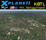
This is an X-Plane 11 and X-Plane 10 scenery package for the W.K. Kellogg Airport (IATA: BTL, ICAO: KBTL, FAA LID: BTL), which is a city owned, public use, joint civil-military airport located three nautical miles (6 km) west of the central business district of Battle Creek, a city in Calhoun County, Michigan, United States. v2.0.0 completely replaces the KBTL v1.0.2, with a brand new scenery, including orthophoto and city building for downtown Battle Creek. For better performance, only the default X-Plane libraries, by Laminar Research, are needed. No third party libraries are used. It includes corrected aprons, ramps, gates, taxiways, lighting system, city downtown buildings, ortho-photoscenery for the airfield area, and (XP11 only) airport ground services (like push back). This scenery was tested and is operational (as of March 20, 2017) in "X-Plane 11 Public Beta #15 64 bit", Windows 10 Home. It was also tested and is also operational (as of March 20, 2017) in "X-Plane 10.51 64 bit", Windows 10 Home. Only the default X-Plane libraries, by Laminar Research, are needed. No third party libraries are used.
| Filename: | US_MI_KBTL__WK_Kellogg_Airport_Battle_Creek_v200.zip |
| License: | Freeware |
| Added: | 22nd March 2017, 00:06:30 |
| Downloads: | 69 |
| Author: | Rui Mesquita |
| Size: | 22.38 MB |
| Category: Flight Simulator 2004 - Panels | |
| F16 |
|
File Description:
FS2004 Panel, F16 Air Show Tour. The panel of this jet fighter has been designed for cross country flying to events worldwide. The 2D cockpit is packed with new gauges that complement this high performance, yet docile aircraft. All gauges, lights, etc. are functional, easy to read, and are panel installed except GPS 500. For long distance flights, the panel contains on-demand refueling capabilities for both ground and air operations. A few of the new gauges are; 180-degree scan navigational radar, triple mode interceptor-refueling-terrain radar, refueling gauge with command screen, fuel center with time/distance remaining computer, new Descentometer for Mach-plus aircraft, analog engine gauges including thrust and fuel efficiency, plus a hangar full of warning and indicator lights. The intercept mode of the ai-radar feeds info to the autopilot to assist in the rendezvous with tanker to allow all-weather, day or night air refueling. Digital data for AP, radio, altimeter, timer, and Descentometer is input via a central keypad. Acknowledge ATC instructions using joystick. Designed for use with Kirk Olsson's F16 Viper. Includes 15 page illustrated instructions plus Intercept and Refueling tutorial. By Glenn Copeland
| Filename: | F16.zip |
| License: | Freeware |
| Added: | 12th January 2007, 03:00:43 |
| Downloads: | 5,780 |
| Author: | Glenn Copeland |
| Size: | 1.83 MB |
| Category: Flight Simulator X - Flight Plans | |
| Flight to the Mayan Curse "Hondo" |
|
File Description:
"AT 8:45 PM the land slided inward for more than 3 minutes. It felt like if everything was being sucked down to the bowels of the earth." Gonzalo Carnesco told the chief of police near the town of Pallasco in the central mountains of Honduras.---Dr. Giulio Ranzetti of the Roman-Mayan Institute of Mysterious Civilizations knew he had to go to "Hondo" for he was sure
he had read, many years ago while exploring the Honduran Jungles, the incredible Mayan Prediction of the "End" as they
called the fracture of the earth. This seemed pretty near to that prediction.
Now you come in......Dr. Ranzetti has hired you to fly him and his two women assistants to the emergency camp near the huge hole, now known as "Hondo". From there you will take the small one man helicopter and fly into the "hole" and take samples and photos of the incredible situation....If you get out of there alive, he is to be flown back to Tegucigalpa where he and his assistants
will fly back to Rome and maybe with the ported evidence...unriddle this riddle.
| Filename: | Flight_to_the_Mayan_Curse_Hondo.zip |
| License: | Freeware, limited distribution |
| Added: | 12th May 2008, 17:09:45 |
| Downloads: | 417 |
| Author: | Gera Godoy Canaova |
| Size: | 2.35 MB |
| Category: Flight Simulator 2004 - AFCAD Files | |
| PAKT Ketchikan International, Alaska, USA |
|
Images related to this file:
File Description:
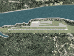
Googlyafcad A&F Data file for Ketchikan International based on Google Earth satellite
data - a small but relatively busy airport located in one of the wettest parts of
Alaska, USA. Ketchikan is Alaska's fifth largest city, with its economy based on
salmon fishing.
For some curious reason the facilities provided in Flight Simulator 2004 omit a crucial
taxiway at the west end of the airport, causing all traffic to taxi from the opposite
end. These files redress this issue, and also provide realistic levels of parking for
commercial and general aviation traffic, allowing you and your "AI" traffic to land,
taxi, park and take off in a realistic manner. The layout has been cunningly designed
to fit both with the Flight Simulator default scenery and version 2 of Alan Wright's
enhanced scenery (paktv2.zip on AVSIM) and is compatible with both in every respect.
Apart from conventional and water-based general aviation aircraft Ketchikan International
is regularly served by commercial flights of Alaska Airlines and by smaller operators
such as Alaska Central Express, Everts Air Alaska and LAB Flying Service. [File re-uploaded at request of AVSIM]
| Filename: | PAKT_Ketchikan_International_Alaska_USA.zip |
| License: | Freeware |
| Added: | 29th May 2010, 09:28:41 |
| Downloads: | 1,266 |
| Author: | John Hinson |
| Size: | 206.01 KB |
| Category: Flight Simulator X - Scenery | |
| The Hawaiian Islands - Kauai, Part 1 of 5 |
|
File Description:
The complete scenery package is 446MB in size. In order to accommodate AvSim's file size requirement, this scenery has been broken into five smaller files. However, all five files -- Hawaii-Kauai-RS-01.zip through Hawaii-Kauai-RS-05.zip -- are necessary for this scenery to work properly. My apologies in advance for the added complexity this involves. "Hawaii-Kauai-RS-01" includes a ReadMe with detailed instructions on how to install this scenery.
Kauai itself is the fourth largest of the main Hawaiian Islands. Also known as the "Garden Isle" due to it's lush tropical foliage, it is located about 105 miles (170 kilometers) west of Oahu and just to the east of tiny Niihau. The east side of Mount Wai'ale'ale is considered to be one of the wettest spots on earth receiving an average annual rainfall of 460 inches (1,200 cm). All that water has carved out deep valleys in the central mountains, the most scenic of which is Waimea Canyon, often referred to as "The Grand Canyon of the Pacific". From shoreline cliffs to mountainous heights, to pristine beaches, enjoy exploring this picture postcard perfect landscape.
| Filename: | The_Hawaiian_Islands__Kauai_Part_1_of_5.zip |
| License: | Freeware |
| Added: | 13th July 2010, 17:03:20 |
| Downloads: | 6,112 |
| Author: | Rich Sorochak |
| Size: | 88.18 MB |


© 2001-2026 AVSIM Online
All Rights Reserved
Privacy Policy |