
Where Flight Simulation Enthusiasts Gather from Around the World!
AVSIM Library - Search Results

| Category: Prepar3D V1-4 - Scenery | |
| Bloukrans and Storms River (Paul Sauer) bridges – South Africa |

|
Images related to this file:
File Description:
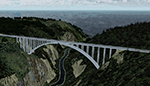
The Bloukrans and Paul Sauer (over the Storms river) bridges are on the N2 highway between Plettenberg Bay and Port Elizabeth on the scenic garden route in the Eastern Cape, South Africa. I made the custom scenery to try some Blender techniques using the P3D 4.5 SDK and tested it in P3D V5 using the ORBX Africa LC and Pilots NG2020 mesh products (I included a fix for the default V5 mesh). You will find the world's highest commercial bungee jump from the Bloukrans bridge, 216m above the river below. Take off from FAPG and fly a heading of 95 degrees for 32 km to get to the Bloukrans bridge (just off the coast). Follow the highway further east for another 26 km to get to the 120m high Paul Sauer bridge, where I included some additional eye candy.
| Filename: | Bloukrans_and_Storms_River_Paul_Sauer_bridges__Sou.zip |
| License: | Freeware |
| Added: | 14th July 2020, 19:15:53 |
| Downloads: | 179 |
| Author: | Johan Pienaar |
| Size: | 26.95 MB |
| Category: Prepar3D V5 - Scenery | |
| Victoria Falls Bridge – Southern Africa |
|
Images related to this file:
File Description:
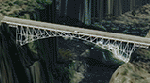
The Victoria falls bridge is located just below the spectacular Victoria water falls in the Zambezi River linking Zimbabwe and Zambia. The steel bridge was completed in 1905 and spans the 200m wide and 128 m wide gorge just below the 1708 m wide falls. This area seems to be a bit neglected in the sim despite the latest add-ons so I decided to spruce it up a little by adding a spray effect for the falls and making some changes to the surface to try to show the waterfall.
I used the P3D 5.3 SDK and tested it in P3D V5.3 using the ORBX Africa LC and Pilots NG2020 mesh products The falls and bridge is 10nm to the north of FVFA in Zimbabwe or 165 degrees from FLNH if you want to approach it from the Zambia side.
| Filename: | Victoria_Falls_Bridge___Southern_Africa.zip |
| License: | Freeware |
| Added: | 1st February 2022, 01:06:27 |
| Downloads: | 66 |
| Author: | Johan Pienaar |
| Size: | 12.78 MB |
| Category: Flight Simulator X - Scenery | |
| EGHA Compton Abbas |
|
File Description:
All additional Buildings were placed using default objects.
AI traffic uses default aircraft which was scheduled by hand using the TrafficDatabaseBuilder from the SDK tools provided by FSX Deluxe.
Any additional roads and modified Landclass & water features were created using FSX-KML.
This package adds the apron , Hangars, clubhouse and the fueling station has been moved to the correct spot between the hangars.
Some of the local roads have been added to allow road access to the airfield.
The main wooded areas have been added to the North and south of the airfield and cropland defined surrounding the immediate area although FSX insists on putting trees on some steeper slopes.
I have also included 3 of the villages nearby , Compton Abbas, Ashmore and Fontmell Magna .
It also provides parking spots and ATC interaction along with some AI traffic.
Hope you like it :)
| Filename: | EGHA_Compton_Abbas.zip |
| License: | Freeware, limited distribution |
| Added: | 1st October 2007, 17:08:37 |
| Downloads: | 1,887 |
| Author: | Len Hickman |
| Size: | 17.45 KB |
| Category: Flight Simulator 2004 - Scenery | |
| Modified SRTM relief 76 m for Slovakia |
|
File Description:
This Slovak terrain mesh 76 m (LOD9) is made from the 3arc-sec SRTM. The voids in the source data were filled by the interpolation. Both the primary processing of the 3arc-sec data and the rendering of the terrain in the FS cause flattening and simplifying of the real shape of the terrain. This phenomenon was partially compensated by the sharpening of the source data.
Made by the programs Surfer (Golden Software) and MS Terrain SDK 2000 and 2002. The relief covers the area N49.9219 E016.1719 to N47.4609 E022.9687 in the boundaries of the LOD9 quadrants. This scenery contains only the elevation data. The other elements of the basic terrain as the landclass, locally used airborne photos, vector roads, rivers and lakes are available in different sceneries by other authors and they are continuously developed.
| Filename: | Modified_SRTM_relief_76_m_for_Slovakia.zip |
| License: | Freeware, limited distribution |
| Added: | 28th May 2010, 19:40:13 |
| Downloads: | 4,604 |
| Author: | Vladimir Stoje |
| Size: | 19.36 MB |
| Category: Flight Simulator 2004 - Miscellaneous Files | |
| Flight Simulator Scenery Tutorial - How to decompile, edit, and recompile default scenery object BGL files |
|
File Description:
This is a simple tutorial in a dual format, one HTML for web-based reading and the other for reading within Microsoft Word. The tutorial contains a thorough, step-by-step process on editing default scenery object BGL files within Flight Simulator. It covers everything from the task of decompiling the stock BGL file using BGLXML or NewBGLAnalyze, editing it using SceneGenX scenery Generator and Notepad, and recompiling the source code XML into a BGL file again by using the BGLCOMP SDK. This tutorial was the result of a request by a fellow scenery creator, in combination to my quest for further increasing the realism of one of Flight Simulator's stock airports (Sanderson Field, Shelton, WA). There's specific instructions, and a final word on the touchy topic of editing stock BGL files contained within the tutorial as well.
| Filename: | Flight_Simulator_Scenery_Tutorial__How_to_decompil.zip |
| License: | Freeware |
| Added: | 13th December 2005, 13:50:03 |
| Downloads: | 5,884 |
| Author: | Steven Rosenow |
| Size: | 24.52 KB |
| Category: Flight Simulator X - Original Aircraft | |
| Bristol F2B Mk.1 Part 1 |
|
File Description:
Flight Simulator X version of the Bristol Fighter Mk.1 or 'Biff' as it was called by its crews in WW1. This file is part 1 of a 4 part download and contains visual models and textures depicting 3 aircraft with the earlier short form exhausts. No other downloads are required to make this functional. The other 3 downloads are optional variants. This aircraft was modeled using 3DS Max 8.0 and compiled using FSX SDK tools and will only work in FSX or higher. It is NOT compatible with FS2004. The aircraft makes full use of FSX materials and also features skinned animated crew members in the external model. It also features a detailed virtual cockpit. All instruments, levers and selectors are modeled in the 3D model. It does not use the FSX gauge system and there is NO 2D cockpit.
| Filename: | Bristol_F2B_Mk1__Part_1.zip |
| License: | Freeware, limited distribution |
| Added: | 2nd February 2007, 03:22:25 |
| Downloads: | 7,365 |
| Author: | Robert Bruce |
| Size: | 22.04 MB |
| Category: Prepar3D V1-4 - Utilities | |
| FSFO V3 |
|
Images related to this file:
File Description:
Flight Simulator First Officer V3 is a generic copilot designed to work with any aircraft that conform to Xplane (via XPUIPC), FS9, FSX and P3D V3/V4 SDK; in short, it adds a touch of realism while providing a copilot to share cockpit responsibilities. FSFO V3 does not require strict adherence to Standard Operating Procedures (i.e. scripts), reading lengthy manuals or precise speech. To that end, it can be as complex or simple as you want; for example, FSFO can complete the entire Before Start Checklist, or only those functions you chose not to accomplish. Regardless, he will check every switch to ensure it's placed in the correct position. Just hit connect and fly with confidence that your First Officer is there sharing responsibilities
For a list of features, go here: http://flightsimaddons.proboards.com/thread/106/introducing-fsfo-v3
| Filename: | FSFO_V3.zip |
| License: | Freeware, limited distribution |
| Added: | 18th June 2019, 16:21:05 |
| Downloads: | 706 |
| Author: | Matthew King |
| Size: | 201.19 MB |
| Category: Flight Simulator X - Scenery | |
| Puck (EPCK) vintage floatplane base |
|
Images related to this file:
File Description:
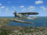
This is a re-upload of the scenery available previously on Avsim. Puck was the second floatplane base in Europe, constructed between 1911-12. Because of the calm waves of Puck Bay, the Germans organised there a test base where different types of floatplanes and seaplanes were tested. After the end of the First World War, the aerodrome was taken by the Poles and served as a home base of Morski Dywizjon Lotniczy (Naval Squadron) until the outbreak of Second World War. The aerodrome was also in use after the 1945 and remained active until the early 50's.
The scenery consists of custom gmax objects, detailed photoscenery and a few city landmarks. All the objects were compiled using FSX-SDK. We recommend you to fly there using Lublin R.XIII package by Michael Puto and Jastarnia aerodrome scenery. Happy landings!
| Filename: | Puck_EPCK_vintage_floatplane_base.zip |
| License: | Freeware, limited distribution |
| Added: | 26th January 2011, 23:59:02 |
| Downloads: | 1,201 |
| Author: | Marek M. Misiewicz, Lukasz Kubacki |
| Size: | 42.45 MB |
| Category: Flight Simulator 2004 - Scenery | |
| Modified SRTM Relief 76 m for Czech Republic |
|
File Description:
This Czech Republic terrain mesh 76 m (LOD9) is made from the 3arc-sec SRTM. Small voids in the source data were filled by the interpolation. Both the primary processing of the 3arc-sec data and the rendering of the terrain in the FS cause flattening and simplifying of the real shape of the terrain. This phenomenon was partially compensated by the sharpening of the source data. Made by the programs Surfer (Golden Software) and MS Terrain SDK 2000 and 2002. The relief covers the area N51.1523 E011.9531 to N48.5156 E018.9844 in the boundaries of the LOD9 quadrants. This scenery contains only the elevation data. The other elements of the basic terrain as the landclass, locally used airborne photos, vector roads, rivers and lakes are available in different sceneries by other authors and they are continuously developed.
| Filename: | Modified_SRTM_Relief_76_m_for_Czech_Republic.zip |
| License: | Freeware |
| Added: | 22nd December 2003, 21:25:07 |
| Downloads: | 6,720 |
| Author: | Vladimir Stoje |
| Size: | 20.81 MB |
| Category: Flight Simulator X - Scenery | |
| Grise Fiord Airport CYGZ |
|
File Description:
Grise Fiord, NWT Canada scenery - CYGZ (FSX).
This is a fictitious rendition of the actual and VERY REMOTE Airport at Grise Fiord in the Canadian NWT - CYGZ.
Grise Fiord is the most northerly community in Canada.
Only operators with considerable experience should use this aerodrome at all. Bring your Twin Otter. There are places to fly your helocopters too. (Explore the oil rigs or see if you can land on one of the destroyers passing by).
See the whales!
See: http://www.copanational.org/PlacesToFly/airport_view.php?pr_id=13&ap_id=288
For great photo's of the area: http://www.arcticcircle.ca/Baffin/Grise/
Virtual improvements have finally come to this area where the ice never melts.
This is freeware. I hope you enjoy it.
Designed with the FS X Sdk Scenery function of the Mission builder and the Abacus Scenery shortcut tool.
This scenery is frame rate friendly.
| Filename: | Grise_Fiord_Airport_CYGZ.zip |
| License: | Freeware |
| Added: | 26th January 2007, 02:37:13 |
| Downloads: | 1,520 |
| Author: | Bob Caparoula |
| Size: | 2.47 MB |
© 2001-2026 AVSIM Online
All Rights Reserved
Privacy Policy |