
Where Flight Simulation Enthusiasts Gather from Around the World!
AVSIM Library - Search Results

| Category: Flight Simulator X - Scenery | |
| Aeropuertos de Isla San Andrés y de Isla Providencia (SKSP & SKPV), Colombia. |

|
File Description:
The delivery includes TWO airports: 1- Gustavo Rojas Pinilla (SKSP) on San Andrés Island, 2- El Embrujo (SKPV) on Providencia Island; both belonging to Colombia (Caribbean Area).
The delivery includes conditioning of the runways and taxiing of the airport facilities using original objects from the FSX Acceleration Pack.
The height of the terrain of the islands was also conditioned, and various objects that force you to take a low-altitude plane or helicopter ride for observation and discovery.
In Providencia you can try a landing approaching by the sea very close to the tropical forest (includes app positions to use gps in flight planner); In the same way, dare to take off on Route 35 without running into the treetops, trusting in your ability.
In San Andrés there will be many tourists on the runway headwaters taking photos of your aircraft arriving or departing from the airport !! They are waiting for you!
| Filename: | Aeropuertos_de_Isla_San_Andrs_y_de_Isla_Providenci.zip |
| License: | Freeware |
| Added: | 8th January 2021, 23:31:13 |
| Downloads: | 871 |
| Author: | Cristóbal Laje Ros |
| Size: | 23.63 MB |
| Category: Prepar3D V1-4 - Scenery | |
| TTCP - A. N. R. Robinson International Airport |
|
Images related to this file:
File Description:
P3Dv4.5 - A. N. R. Robinson International Airport (formerly Crown Point International Airport) - IATA TAB, ICAO TTCP. Version 1.0
A. N. R. Robinson International Airport (formerly Crown Point International Airport - IATA: TAB, ICAO: TTCP) is an international airport located on Crown Point, Tobago in Trinidad and Tobago.
It is located in the southwesternmost part of the island, near the town of Canaan, and 11 km (6.8 mi) from the capital, Scarborough.
The airport is one of two international airports serving the twin isle republic of Trinidad and Tobago.
The other airport is located on the island of Trinidad, Piarco International Airport.
Crown Point International Airport has two terminals. The International Terminal was once both the regional and international passenger terminal for the airport but has been renovated to serve as an all-international terminal. It serves international cargo flights, general aviation and helicopter flights. It has seven aircraft parking positions
This scenario was only tested on P3Dv4.5.
| Filename: | TTCP__A_N_R_Robinson_International_Airport.zip |
| License: | Freeware |
| Added: | 16th June 2022, 06:42:12 |
| Downloads: | 258 |
| Author: | Eduardo Puelker |
| Size: | 21.17 MB |
| Category: Flight Simulator 2004 - Aircraft Repaints, Textures and Modifications | |
| Royal Air Force and Royal Navy, Sikorsky S-55 Whirlwinds - v2 |
|
Images related to this file:
File Description:
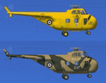
These are six repaints for the Alphasim (Virtavia) Sikorsky S-55 Whirlwind. Four of the textures are Royal Air Force, two are Royal Navy.
1. 28 sqn, RAF, Hong Kong 1968ish.
2. Fictional tactical colours that were applied to some RAF transport aircraft in the 1960's.
3. Central Flying School, RAF Shawbury, 1960's and 70's.
4. 848 Sqn, RN, HMS Bulwark, 1961.
5. Assault helicopter from HMS Albion, 1960's.
6. 22 Sqn, RAF, SAR 1970's.
Non of the repaints are the correct model because there isn't an HAS7 or HAR10 model available in FS9. Not as good as this S-55 anyway. Four of these repaints were uploaded previously but were lost. I was asked if I might upload them again so here they are plus two more. For FS9, but should work in FSX with a little tweaking.
| Filename: | Royal_Air_Force_and_Royal_Navy_Sikorsky_S55_Whirlw.zip |
| License: | Freeware |
| Added: | 11th March 2012, 19:44:28 |
| Downloads: | 481 |
| Author: | Nick Bradin-Alphasim (Virtavia) |
| Size: | 9.07 MB |
| Category: Flight Simulator X - Scenery | |
| "Your Own Sea Port"..Part II of "Your Own" |
|
File Description:
This scenery is Part II of "Your Own" Series. The first one is "Your own AirPort"....
slowly but surely a community is being born!!!!!!...what do you get with YOSP??
--
"YO Airport" has contracted the " Marching Band and Construction Ltd" to construct the " YO-Seaport" near the rich Oil Fields of the coast. MBC Ltd, has thus proceeded full blast on this major important Sea Port which will give traffic to YO Airport and sorroundings.....Now planes will fly on rigid schedules between these two airfields......
later YO-Hill Airfields(Part III) will come along in the mountains in small lakes and Sea Stops...or small seaplane destinations....for more Fun and activities!!!!
What does "Your Own Sea Port" has for you.....?and what can you do there??
1) Two Airfields, one grass for small private planes and one Concrete for Commercial traffic ( new technique so it won´t be "sunk" with whatever mesh you have!!!) ...........+ Floatplane Base!!!
2) Helicopter Pad at the Port Hospital...(lighted)
3) Rescue Sailors at burning ship!!!!---(ship sinking fast!!)...take them to the Port´s Hospital.
4) Check moving traffic with any chopper.( There is a red corvette which must be checked with some women driving too fast!!!)
5) Participate in:
Road Race ( Need a car!!)...Prices galore!!!
Boat Race around Red Bull Pylons (need a Boat!!)...RedBull guys left them here for good!!!
Fly a Race at the same Pylons...(Really Hard!!!!)
6) Fly Tourists to Fishing Lake where Bass Abounds..(Need Floatplane).
8) Fly with your Navy Patrol plane and check on some "Strange Submarine
taking pictures of the port"...if necessary blow it to smitherins!!!!!!!
9) Open a New Airline....YO Air Service Inc...
10) Fly around and take pictures.
11) Take executives to the Oil Facilities in the Interior (EpisodeIII)...
or just fly around with your gal, wife or hummmm, hummmm.............or go fly under its three bridges!!!!!
12) Take passenger from the "Float Plane" Airpark, near the hospital, to lakes and rivers. The Mayor of YOSP will be giving the "city Keys" to all Pilots
who makes four consecutive loops in a helicopter on Sunday at 11:42:45.
| Filename: | Your_Own_Sea_PortPart_II_of_Your_Own.zip |
| License: | Freeware, limited distribution |
| Added: | 28th November 2008, 15:48:14 |
| Downloads: | 1,513 |
| Author: | Gera Godoy Canova |
| Size: | 900.13 KB |
| Category: Flight Simulator 2004 - Scenery | |
| Glacier Bay - Alaska/Canada, Version 2, Part 1 of 2 |
|
Images related to this file:
File Description:
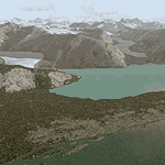
Glacier Bay v2 is a complete replacement of the default FS2004 landscape and scenery of more than 90,000 square kilometers (36,000 sq miles) of Southeast Alaska and adjacent areas of Yukon and British Columbia. File 1 of 2 (also requires glbayv2b.zip)
Landscape enhancements include high-resolution terrain mesh, detailed shorelines, rivers, lakes, and glaciers, and accurate land cover data with custom seasonal ground textures. Inland water bodies can be made to "freeze over" via an on/off switch. Other landmarks include the settlements of Juneau, Haines, Skagway, Yakutat, Atlin, and Carcross as well as road and railroad networks, cabins, lodges, and lighthouses. We modeled or enhanced 16 main airfields (plus one fictitious airstrip), 20 unlisted airstrips, 16 seaplane bases, and seven heliports. We've also included AI ship traffic in various locations as well as optional flightplans for GA and floatplane AI traffic.
Glacier Bay v2 is fully compatible with other third-party add-ons, including terrain mesh (FSGlobal, FS Genesis, etc.), ground textures (Ground Environment, BEV, FScene, etc.), and landscape enhancements (Ultimate Terrain Canada/Alaska, Misty Fjords, Tongass Fjords, Freight Dogs). A configurator panel (requires .Net Framework!) allows users to set compatibility options and to choose levels of scenery detail. We provide an autoinstaller and detailed documentation with a sectional map of the coverage area and a list of weblinks to real-world information.
For feedback and questions, please visit the Glacier Bay v2 support forum at http://forums.fsaddon.eu/viewforum.php?f=10. This project is a collaboration of nine FS developers from Germany, Austria, USA, and Canada, logging more than 1000 hours of work over the past 14 months. We acknowledge the kind support of FSAddon.com. However, this project is independent of any commercial company or product. Enjoy!
| Filename: | Glacier_Bay__AlaskaCanada_Version_2_Part_1_of_2.zip |
| License: | Freeware, limited distribution |
| Added: | 28th May 2010, 19:34:54 |
| Downloads: | 41,280 |
| Author: | Holger Sandmann, Rainer Duda, Michael Eder, Scot Fraser, Manfred Herz, Jay Langham, Jon Patch, Larry Silsbee, and Jim Vile |
| Size: | 56.46 MB |
| Category: Flight Simulator 2004 - Scenery | |
| Glacier Bay - Alaska/Canada, Version 2, Part 2 of 2 |
|
Images related to this file:
File Description:

Glacier Bay v2 is a complete replacement of the default FS2004 landscape and scenery of more than 90,000 square kilometers (36,000 sq miles) of Southeast Alaska and adjacent areas of Yukon and British Columbia. File 2 of 2 (also requires glbayv2a.zip)
Landscape enhancements include high-resolution terrain mesh, detailed shorelines, rivers, lakes, and glaciers, and accurate land cover data with custom seasonal ground textures. Inland water bodies can be made to "freeze over" via an on/off switch. Other landmarks include the settlements of Juneau, Haines, Skagway, Yakutat, Atlin, and Carcross as well as road and railroad networks, cabins, lodges, and lighthouses. We modeled or enhanced 16 main airfields (plus one fictitious airstrip), 20 unlisted airstrips, 16 seaplane bases, and seven heliports. We've also included AI ship traffic in various locations as well as optional flightplans for GA and floatplane AI traffic.
Glacier Bay v2 is fully compatible with other third-party add-ons, including terrain mesh (FSGlobal, FS Genesis, etc.), ground textures (Ground Environment, BEV, FScene, etc.), and landscape enhancements (Ultimate Terrain Canada/Alaska, Misty Fjords, Tongass Fjords, Freight Dogs). A configurator panel (requires .Net Framework!) allows users to set compatibility options and to choose levels of scenery detail. We provide an autoinstaller and detailed documentation with a sectional map of the coverage area and a list of weblinks to real-world information.
For feedback and questions, please visit the Glacier Bay v2 support forum at http://forums.fsaddon.eu/viewforum.php?f=10. This project is a collaboration of nine FS developers from Germany, Austria, USA, and Canada, logging more than 1000 hours of work over the past 14 months. We acknowledge the kind support of FSAddon.com. However, this project is independent of any commercial company or product. Enjoy!
| Filename: | Glacier_Bay__AlaskaCanada_Version_2_Part_2_of_2.zip |
| License: | Freeware, limited distribution |
| Added: | 28th May 2010, 19:36:31 |
| Downloads: | 40,552 |
| Author: | Holger Sandmann, Rainer Duda, Michael Eder, Scot Fraser, Manfred Herz, Jay Langham, Jon Patch, Larry Silsbee, and Jim Vile |
| Size: | 85.99 MB |
| Category: Flight Simulator 2004 - Aircraft Repaints, Textures and Modifications | |
| OMNI Aviation Cessna 182 repaint (Default) |
|
File Description:
OMNI Aviation is a Portuguese company whose services include executive/private jets & turbo-props & helicopter charters & leasing, as well as an aviation school, with its headquarters in Cascais Municipal Airport in Portugal (ICAO: LPCS).
Besides these activities, OMNI is also the owner of Portuguese charter airline White Airways, which also operates the ATR-72's on behalf on the Portuguese national carrier TAP Air Portugal, under the subsidiary name TAP Express.
I decided to do this paint because I recently enrolled in an ATPL course at this school, and I wanted a 'familiar aircraft' in my FS2004 collection. Although the original airplane is a Cessna 172 and OMNI owns no C182's, I made this repaint for the 182 because not only do I like it better, it was the only default FS2004 plane I had a paintkit of. A repaint of the 172 may come soon though if I can find a paintkit for it!
Also this is my first and so far only repaint for FS ever!
| Filename: | OMNI_Aviation_Cessna_182_repaint_Default.zip |
| License: | Freeware |
| Added: | 22nd October 2017, 18:39:56 |
| Downloads: | 83 |
| Author: | Leonardo Santos |
| Size: | 1.76 MB |
| Category: Flight Simulator 2004 - AFCAD Files | |
| Winnipeg Intl with Crosswind Runways |
|
File Description:
A high quality AFCAD2 file for Winnipeg Int'l airport, Manitoba, Canada. This file has been built from scratch using information from the internet. This AFCAD2 will extend the runways as follows - 07/25 is now 9000ft, 13/31 is now 9100ft and 18/36 is now 12000ft long. In addition, improvements have been made to runway lighting, VASI and approach lighting. Assigned parking is provided for all commercial airlines that serve YWG and also for the following companies - FedEx, UPS, Perimiter Aviation, Esso, Shell, Skyward Aviation and the Canadian Armed Forces. This airport also features extensive GA parking, Helicopter pads, Air Canada maintenance area, new taxiways and improved apron and taxiway night lighting. Using the crosswind runway technique, all 3 runways can also now be used simultaneously. There are 2 versions included here - (1) Concrete taxiways and runways, (2) Asphalt Taxiways and runways. This file is only for use with the addon scenery by Adam Bentley and David Madge (cywg_v101.zip) and has not been tested with the default airport.
| Filename: | Winnipeg_Intl_with_Crosswind_Runways.zip |
| License: | Freeware |
| Added: | 28th February 2005, 15:45:06 |
| Downloads: | 1,777 |
| Author: | Lee Brompton |
| Size: | 57 KB |
| Category: Flight Simulator 2004 - Scenery Design | |
| Arctic set |
|
File Description:
Finney Air presents
EZScenery Arctic set v1
This package includes 24 Arctic type items to be used with Abacus EZScenery. You MUST have EZScenery installed for this set to work.
Build your own remote station in any place of the world. Just remember where you made the station, wrong place to loose your bearings.
These include:
6 Types of "Snowcats" 2 yellow, 2 orange, 1 yellow with roof racks, and 1 orange with pax cab
1 Fully loaded Snowcat with loaded trailer
2 types of trailers, 1 for static and 1 for use as tow unit (NOTE: Trailers not designed for helicopter landings)
1 Small cargo box
1 long cargo box
1 Fuel drum
1 fuel drum with pump
1 Pallet
1 Green expedition tent
3 smaller tents in red, green, and blue
1 Polar First flag on pole
1 VERT flag on pole
1 Scientists work table with gear on it
1 Main base with sat. tower (WARNING:may be a bit on frame rate)
1 Bunk house (not pictured)
1 Sat. tower (not pictured)
| Filename: | Arctic_set.zip |
| License: | Freeware |
| Added: | 2nd March 2007, 14:50:26 |
| Downloads: | 2,319 |
| Author: | Finney Air / Rob Finnegan |
| Size: | 1.25 MB |
| Category: Flight Simulator 2004 - Scenery | |
| Clinton Point CWCP, Horton River CWHR & Keats Point CWKP; DEW sites in Northwest Territories, Canada |
|
Images related to this file:
File Description:
These are three DEW line sites in northern mainland Canada, to the east of Tuktoyaktuk.
Clinton Point is almost 300 miles east of Tuktoyaktuk and on the Northwest Territories and Nunavut border. It is the site of a closed DEW station (closed in 1993) and all the buildings have been removed, unlike many other sites where buildings are still almost complete. The roads and the gravel runway down by the beach are still there.
Horton River is 150 miles east of Tuktoyaktuk, up on higher land above the cliffs at around 500 feet ASL. The NWS (North Warning System) replaced the I site which was there previously and which ceased operations in 1963. The NWS is serviced by helicopter from a barge 400 yards away on the beach.
Keats Point is 270 miles east of Tuktoyaktuk, 7 miles from the coast but significantly close to a lake, which was probably used for float plane delivery in the summer (or ski plane delivery in the winter) of NWS station elements during construction.
| Filename: | Clinton_Point_CWCP_Horton_River_CWHR__Keats_Point_.zip |
| License: | Freeware, limited distribution |
| Added: | 17th July 2012, 18:57:08 |
| Downloads: | 279 |
| Author: | Roger Wensley |
| Size: | 2.07 MB |
© 2001-2026 AVSIM Online
All Rights Reserved
Privacy Policy |