
Where Flight Simulation Enthusiasts Gather from Around the World!
AVSIM Library - Search Results

| Category: Flight Simulator 2004 - Aircraft Repaints, Textures and Modifications | |
| Spanish army and air force textures for aerospatiale superpuma |

|
File Description:
Spanish textures for the Eurocopter AS-332C1 Super Puma. Compatible with FS2002 and FS 2004.
Original helicopter model made by Dirk Fassbender [email protected].
Panel design and flight dynamics by Nick Karatzides [email protected] or [email protected].
Super puma serves in the Spanish Ejército de Tierra (land forces) and in the Spanish Air Force. Four paintschemes are included in this pack: normal low visibility grey for the Spanish Airforce 802 y 803 squadrons, the same scheme with ISAF markings (Afghanistan international troops, Herat base), and green and camo schemes for the FAMET (Fuerzas Aeromóviles del Ejército de Tierra).
You need to have the model with the panel and flight dynamics from avsim (available as as-332c1_haf_v1).
Just drop the folders in the texture folder and overwrite the aircraft config file. Remember to make a
backup copy of your previous aircraft file.
This is freeware. It is strictly forbidden the use of the model or textures as payware, and also to post it
in FSplanet.
All suggestion are welcome.
Alberto García Lledó [email protected]
| Filename: | Spanish_army_and_air_force_textures_for_aerospatia.zip |
| License: | Freeware |
| Added: | 27th September 2007, 17:42:58 |
| Downloads: | 675 |
| Author: | Alberto García Lledó |
| Size: | 4.11 MB |
| Category: Flight Simulator 2004 - Aircraft Repaints, Textures and Modifications | |
| AS 350 "Miami Dade Police" |
|
Images related to this file:
File Description:
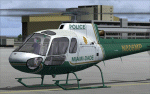
This is a repaint of the Nemeth Designs (ND) freeware AS 350 in the real world livery of the "Miami-Dade Police" AS350 for FS9 (FS2004) only. I believe this is the only repaint of the Miami Dade helicopter for public use as I was unable to locate any others, but that doesn't mean they may not exist somewhere. With that, I was unable to find too many decent photos of the chopper either so there has been a little guess work with this paint, primarily the under carriage. This is a complete aircraft, so no other files are required to fly her. All repainted textures have been saved in 32 bit format for enhanced detail. Installation, Distribution and Contact details can be located ion the TC Read Me file that is included with this download. Thanks to all of you who have supported my efforts, it is appreciated. In the event that someone from the Miami Dade Police Aviation Unit sees this - it would be appreciated if they could let me know of its accuracy - cheers :)
| Filename: | AS_350_Miami_Dade_Police.zip |
| License: | Freeware, limited distribution |
| Added: | 27th February 2012, 03:08:14 |
| Downloads: | 280 |
| Author: | Tony Cannon and Nemeth Designs |
| Size: | 18.21 MB |
| Category: Flight Simulator 2004 - Scenery | |
| Saglek CYSV in northern Labrador, Newfoundland Canada |
|
Images related to this file:
File Description:
Kangiqsualujjuaq is in northern Quebec on the east side of Ungava Bay, and the rocky coastline stretches north from there for 130 miles before turning sharply to head south as the Atlantic shore of Labrador. On this shore and 120 miles almost due east of Kangiqsualujjuaq is Saglek, once a US radar base as part of the DEW line, and then a Canadian base with a Long Range Radar sited 1,200 feet above the airstrip on the top of the vertical cliff. The airstrip is still in use today as an access to the Torngat Mountains Canadian National Park area further north, with organised summer camps and walks etc and helicopter relays from airstrip to campsites. Saglek closes the gap between my post of Kangiqsualujjuaq and the string of airfields further south on the Labrador coast, such as Nain, Davis Inlet, Hopedale, Makkovik, and Postville etc. These have all been made by Flight Ontario and posted along with the Goose Bay Air Base, which also functions as a civil airport.
| Filename: | Saglek_CYSV_in_northern_Labrador_Newfoundland_Cana.zip |
| License: | Freeware, limited distribution |
| Added: | 17th August 2017, 17:11:29 |
| Downloads: | 162 |
| Author: | Roger Wensley |
| Size: | 3.86 MB |
| Category: Flight Simulator 2004 - Scenery | |
| PAUT - Akun Island - Alaska, USA |
|
Images related to this file:
File Description:
Akun Island is close to Akutan, only 7 miles away from the village and the Trident fish processing plant that is just west of the village. Unfortunately those 7 miles are over the sea, as the airport has been built on a different island where there are fewer hills. The link is by hovercraft, which is included as AI in this post along with a "seaport" that boasts only an apron down by the beach. PAUT has a single runway aligned 09-27 which is 4,500 feet long and has a surrounding gravel base. There are daily flights from Dutch Harbor by Grant Aviation, more than one if more are required. The Ai contains these flights, plus a late afternoon Coastguard helicopter flight is added to the revised St Paul Island AI included here. Adjacent to the airport there is a camp for housing labour who were employed on the airport construction, and this is now available for wildlife survey teams or whoever else needs to find accommodation while working on Akun Island.
| Filename: | PAUT__Akun_Island__Alaska_USA.zip |
| License: | Freeware, limited distribution |
| Added: | 27th January 2015, 23:11:43 |
| Downloads: | 472 |
| Author: | Roger Wensley |
| Size: | 4.13 MB |
| Category: Flight Simulator X - Scenery | |
| * Darłowo AFB * - EPDA |
|
Images related to this file:
File Description:
EPDA Airport in Darłowo is a military airfield located on the Polish Baltic coast.
It serves as a base for the naval aviation of the Polish Navy, primarily used for helicopter operations.
Its main tasks include coastal patrols, search and rescue missions, and anti-submarine warfare.
The airfield is home to multi-role helicopters, including the Mi-14 and W-3 Sokół.
Its history dates back to World War II when it was built by the Germans.
After the war, it was taken over by the Polish military and has since functioned as a naval aviation base.
The airport features a concrete runway and infrastructure adapted for the operation of helicopters and military aircraft.
Due to its strategic location on the Baltic Sea, it plays a crucial role in operations related to the security of Poland’s territorial waters.
The airfield is not open to civilian aviation and is used exclusively for military purposes.
Nowadays, it remains an essential part of Poland’s defense system and participates in NATO exercises.
| Filename: | _Darowo_AFB____EPDA.zip |
| License: | Freeware |
| Added: | 10th February 2025, 17:41:56 |
| Downloads: | 70 |
| Author: | Dawid Drobik |
| Size: | 10.44 MB |
| Category: Flight Simulator X - Scenery | |
| CYXX (2012) Version 2 for FS9, FSX and Prepar3D |
|
Images related to this file:
File Description:

CYXX (2012) portrays the Abbotsford (British Columbia, Canada) Airport - home of the Abbotsford Air Show - and surrounding area as it appeared in late 2012. Abbotsford lies just east of Vancouver and only a short distance north of the US border. CYXX is home to Conair Aviation (a large operator of forest fire-fighting air-tankers), Cascade Aerospace (a major aircraft maintenance operation) and several helicopter training, service and operations facilities.) The recently completed major runway and taxiway extensions are reflected in CYXX (2012). This add-on includes a large selection of custom AI and static aircraft painted to represent airline and privately-owned aircraft based or often seen at CYXX, including every aircraft type currently operated by Conair. CYXX (2012) is compatible with BC Roads (FS9 only), Vancouver+, ORBX FTX USA Canada Pacific Northwest and both FS9 and FSX versions of Ultimate Terrain.
Generally, this new version is visually identical to its predecessor - even though quite different internally. As well, to the extent possible, it is compatible with Prepar3Dv2.
| Filename: | CYXX_2012_Version_2_for_FS9_FSX_and_Prepar3D.zip |
| License: | Freeware, limited distribution |
| Added: | 20th June 2014, 11:41:28 |
| Downloads: | 4,763 |
| Author: | Don Grovestine |
| Size: | 108.71 MB |
| Category: Flight Simulator X - Flight Plans | |
| Flight to the Mayan Curse "Hondo" |
|
File Description:
"AT 8:45 PM the land slided inward for more than 3 minutes. It felt like if everything was being sucked down to the bowels of the earth." Gonzalo Carnesco told the chief of police near the town of Pallasco in the central mountains of Honduras.---Dr. Giulio Ranzetti of the Roman-Mayan Institute of Mysterious Civilizations knew he had to go to "Hondo" for he was sure
he had read, many years ago while exploring the Honduran Jungles, the incredible Mayan Prediction of the "End" as they
called the fracture of the earth. This seemed pretty near to that prediction.
Now you come in......Dr. Ranzetti has hired you to fly him and his two women assistants to the emergency camp near the huge hole, now known as "Hondo". From there you will take the small one man helicopter and fly into the "hole" and take samples and photos of the incredible situation....If you get out of there alive, he is to be flown back to Tegucigalpa where he and his assistants
will fly back to Rome and maybe with the ported evidence...unriddle this riddle.
| Filename: | Flight_to_the_Mayan_Curse_Hondo.zip |
| License: | Freeware, limited distribution |
| Added: | 12th May 2008, 17:09:45 |
| Downloads: | 417 |
| Author: | Gera Godoy Canaova |
| Size: | 2.35 MB |
| Category: Flight Simulator X - AI Flight Plans | |
| Mount Everest Expedition |
|
File Description:
Two flightplans for an expedition to Mount Everest (8852 m). The first flightplan takes you from Lukla (VNLK) airfield at 10000 ft to Mount Everest Climb North: Base Camp. A distance of about 40 km. The recommended inbuilt aircraft for this trip is the "Maule Orion on skis". Be aware that you must climb to about 15000 ft before entering the GPS-path. Also, you should try to land across the slope. Otherwise it could be difficult to stop the aircraft from skiing down the inclined ground!
The second flightplan takes you from Base Camp to Yak Camp* (at about 19000 ft MSL) sitting at a bend of the East Rongbuk Glacier. This is the first camp on the North Route. You should use a helicopter able to climb to about 20000 ft for this route. For example, the inbuilt Bell 206B JetRanger. Though, it will indeed be a challenge with this aircraft!
*= It is called the Yak Camp because it is the point at which the yak herders overnight their yaks on the route up to Advance Base Camp (ABC) at 21300 ft.
| Filename: | Mount_Everest_Expedition.zip |
| License: | Freeware |
| Added: | 1st May 2007, 23:20:13 |
| Downloads: | 1,671 |
| Author: | Ulf Norlinger |
| Size: | 127.04 KB |
| Category: Flight Simulator 2004 - Scenery | |
| Alma CYTF in Quebec Canada |
|
Images related to this file:
File Description:
This is the second of five sceneries around Lac Saint-Jean in Quebec, Canada. Alma, the town, is 7 miles east of Lac Saint-Jean, on both the northern and southern banks of the Saguenay River. The airfield is at the southern edge of the town, with a single 13-31 runway 5,000 feet long and approach lighting at both ends. There is a visible ILS sytem but this was no longer in operation by 2010, the approximate date setting of this scenery. The largest operation on the field, by far, is Panorama Helicopters (actually Helicopteres Panorama) and this is reflected in the AI and a parked static helicopter. The ai includes helicopters that were originally posted as part of the payware Alaska Fjords series, with the permission of FSAddon. There are also other planes listed that will be required here or for the future posts in this series and are included here. The amphibious Beaver AI plane will only be available if you already have the payware Aerosoft Beaver installed, and I should have made it clear that the float Beaver included in the CTD3 AI was also an Aerosoft plane.
| Filename: | Alma_CYTF_in_Quebec_Canada.zip |
| License: | Freeware, limited distribution |
| Added: | 6th November 2017, 19:30:34 |
| Downloads: | 226 |
| Author: | Roger Wensley |
| Size: | 17.42 MB |
| Category: Flight Simulator 2004 - Scenery | |
| Boundary Bay CZBB in British Columbia, Canada |
|
Images related to this file:
File Description:
Boundary Bay is south of Vancouver in British Columbia, close to the US/Canada border. It is the 5th busiest airfield in Canada measured in terms of take offs and landings as there are several training companies based there. The airfield was purchased by Alpha Aviation in 2009 and and modernised for the 2010 Winter Olympics, the main addition being a new terminal. This is an ex-military training base which was built in 1941, and one of the original hangars still survives. The two runways in use now (07/25 5,600' and 12/30 2,750', both of them 100' wide) are reduced asphalted areas of the original runways; the third runway is now an apron for GA parking and has had hangars built along it. There is JetA and 100LL available. The large building at the east end of the north apron is a HQ and maintenance facility for a helicopter company, Heli-one. All of the north apron buildings on the field have been modelled specifically for this scenery, plus the nearby huge greenhouse farm structures which are visible from further away than the airfield is. AI for Boundary Bay will be posted later this week.
| Filename: | Boundary_Bay_CZBB_in_British_Columbia_Canada.zip |
| License: | Freeware, limited distribution |
| Added: | 12th May 2011, 13:30:18 |
| Downloads: | 854 |
| Author: | Roger Wensley |
| Size: | 4.4 MB |
© 2001-2026 AVSIM Online
All Rights Reserved
Privacy Policy |