
Where Flight Simulation Enthusiasts Gather from Around the World!
AVSIM Library - Search Results

| Category: Flight Simulator 2004 - Scenery | |
| The Grenadines Islands Airports V1.1 for use with Antilles 2004 |

|
Images related to this file:
File Description:
This is a self-contained version V1.1 of the airports in the Grenadines chain of islands that I have already posted, modified for use with the Antilles 2004 scenery. I originally made them for stock FS9. The list is Hewanora, Saint Vincent, Bequia, Mustique, Canouan, Union Island, Carriacou, and Maurice Bishop International at the southern end of Grenada. The notes for V1.1 contain some information that should have been included in the first posting. The replacement scenery bgl's include some fixes to Antilles 2004 sea levels where the sea was climbing a hill, additional town landclass for the area close to the airport in Grenada as St Georges now stretches out along the coast, and some revisions to my airports where I found that installing on a second computer gave a slightly different and unsatisfactory result, in particular TVSB on Bequia.
| Filename: | The_Grenadines_Islands_Airports_V11_for_use_with_A.zip |
| License: | Freeware, limited distribution |
| Added: | 7th July 2013, 05:28:12 |
| Downloads: | 574 |
| Author: | Roger Wensley |
| Size: | 17.05 MB |
| Category: Flight Simulator X - Scenery | |
| JZZ - Koliganek Airport - Alaska, USA |
|
Images related to this file:
File Description:
Koliganek Airport (IATA: KGK, ICAO: PAJZ, FAA LID: JZZ) is a state-owned, public-use airport located one nautical mile (1.85 km) east of the central business district of Koliganek,in the Dillingham Census Area of the U.S. state of Alaska. Scheduled airline service to Dillingham Airport is provided by Peninsula Airways (PenAir).The airport opened in 1997.
Increased length of runway 9/27 from 3,000 feet to 3,300 feet.Added runway 17/35 (3,300 feet and 75 feet wide). Changes were based on 2011 construction plans.
Created with Airport Design Editor 9x by ScruffyDuck Software using current FAA documentation and Google Earth measurements, this package offers a replacement for FSX's stock airport. All these enhancements are as close to the real airport as I can get with stock library objects and custom buildings.
| Filename: | JZZ__Koliganek_Airport__Alaska_USA.zip |
| License: | Freeware |
| Added: | 25th December 2014, 01:15:29 |
| Downloads: | 598 |
| Author: | Wayne Roberts |
| Size: | 214.91 KB |
| Category: Flight Simulator X - Scenery | |
| KMKJ - Mountain Empire Airport - Virginia, USA |
|
Images related to this file:
File Description:
Mountain Empire Airport (ICAO: KMKJ, FAA LID: MKJ) is a public use airport in Smyth County, Virginia, United States.[1] It located nine nautical miles (10 mi, 17 km) northeast of the central business district of Marion (in Smyth County)[1] and 13 nautical miles (15 mi, 24 km) west of Wytheville (in Wythe County).[2] The airport is situated between Interstate 81 and U.S. Route 11 (Lee Highway), near Groseclose. It is owned by Smyth Wythe Airport Commission.
This is a complete re-work of the airport. Added taxiway, additional parking aprons and custom buildings.
Created with Airport Design Editor by ScruffyDuck Software using current FAA documentation and Google Earth measurements, this package offers a replacement for FSX's stock airport. All these enhancements are as close to the real airport as I can get with stock library objects and custom buildings.
| Filename: | KMKJ__Mountain_Empire_Airport__Virginia_USA.zip |
| License: | Freeware |
| Added: | 25th January 2015, 15:55:52 |
| Downloads: | 309 |
| Author: | Wayne Roberts |
| Size: | 339.5 KB |
| Category: X-Plane - Scenery | |
| BR AC SBRB - Rio Branco Intl Airport v1.0.0 |
|
Images related to this file:
File Description:
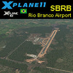
This is an X-Plane 11 and X-Plane 10 scenery package for Rio Branco-Plácido de Castro International Airport (IATA: RBR, ICAO: SBRB) is the airport serving Rio Branco, Brazil. It includes corrected aprons, ramps, gates, taxiways, lighting system, city buildings, ortho-photoscenery for the airfield area, and (XP11 only) airport ground services (like push back). The airport was opened on November 22, 1999 as a replacement to Presidente Médici International Airport, which was then closed. This scenery was tested and is operational (as of April 05, 2017) in "X-Plane 11.00 RC #1 64 bit", Windows 10 Home. It was also tested and is also operational (as of April 05, 2017) in "X-Plane 10.51 64 bit", Windows 10 Home. Only the default X-Plane 11 libraries, by Laminar Research, are needed. No third party libraries are used.
| Filename: | BR_AC_SBRB__Rio_Branco_Intl_Airport_v100.zip |
| License: | Freeware |
| Added: | 6th April 2017, 08:16:03 |
| Downloads: | 185 |
| Author: | Rui Mesquita |
| Size: | 12.93 MB |
| Category: Flight Simulator X - Aircraft Repaints, Textures and Modifications | |
| USAF Douglas C-124C MATS 21035 |
|
Images related to this file:
File Description:
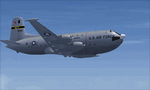
This is a repaint of the Douglas C-124C in USAF colors. The freeware Douglas C-124C for FSX by Jens Kristensen (JBK) is needed for this repaint. MATS, and its succesor- MAC, had by far the largest number of C-124s in Air Force Service. This is a repaint of C-124 serial 52-1035 which was with the 1501 Air Transport Wing (ATW) of MATS, and was based at Travis AFB. The 1501st was discontinued on 8 January 1966 as part of the replacement of MATS by the newly formed Military Airlift Command (MAC), and the MATS aircraft were transferred to the MAC 60th Military Airlift Wing. C-124 52-1035 was retired in December 1969. Textures are 32bit DDS. This repaint was tested on FSX-SE. It should also work on FSX, and P3Dv1-3.
| Filename: | USAF_Douglas_C124C_MATS_21035.zip |
| License: | Freeware |
| Added: | 12th November 2019, 17:40:40 |
| Downloads: | 71 |
| Author: | Ted Giana |
| Size: | 4.95 MB |
| Category: Flight Simulator 2002 - Aircraft Repaints, Textures and Modifications | |
| USAF Douglas VC-118 Independence |
|
File Description:
USAF Douglas VC-118 INDEPENDENCE
Tail-Nr. 46-0505, C/n 42881, of United States
Air Force in colors of 1953 as preserved at
United States Air Force Museum, Wright-Patterson
Air Force Base (WPAFB), Dayton, Ohio, USA.
USAAF officials ordered the 29th production
DC-6 to be modified as a replacement for the
aging VC-54C "Sacred Cow" Presidential
aircraft and was nicknamed "Independence"
for President Truman's hometown in Missouri.
The VC-118 was formally commissioned into
the AAF on July 4, 1947. Probably the plane's
most historic flight occurred when it carried
President Truman to Wake Island in October 1950
to discuss the Korean situation with Gen. Douglas
MacArthur. Another essential "Air Force One"
for all FS2002 propliner fans. A repaint of Tom
Gibson's and Greg Pepper's great DC-6 by
Hans Hermann, Virtual Birds Factory
| Filename: | USAF_Douglas_VC118_Independence.zip |
| License: | Freeware |
| Added: | 12th August 2004, 18:46:44 |
| Downloads: | 681 |
| Author: | Hans U. Hermann |
| Size: | 1.99 MB |
| Category: Flight Simulator X - Scenery | |
| KMFV - Accomack County Airport - Melfa, Virginia, USA |
|
Images related to this file:
File Description:
Accomack County Airport (IATA: MFV, ICAO: KMFV) is a county-owned public-use airport located 1 mile (1.6 km) west of the central business district of Melfa. The airport was built by the United States Army Air Forces about 1942, and was known as Melfa Flight Strip. It was an emergency landing airfield for military aircraft on training flights. It was closed after World War II, and was turned over for local government use by the War Assets Administration (WAA).
This is a complete re-work of the airport with added taxiways, parking and custom buildings. Created with Airport Design Editor by ScruffyDuck Software using current FAA documentation and Google Earth measurements, this package offers a replacement for FSX's stock airport. All these enhancements are as close to the real airport as I can get with stock library objects and custom buildings.
| Filename: | KMFV__Accomack_County_Airport__Melfa_Virginia_USA.zip |
| License: | Freeware |
| Added: | 16th February 2015, 11:56:40 |
| Downloads: | 429 |
| Author: | Wayne Roberts |
| Size: | 292.84 KB |
| Category: Flight Simulator X - Scenery | |
| W91 - Smith Mountain Lake Airport - Moneta, Virginia, USA |
|
Images related to this file:
File Description:
The Smith Mountain Lake Airport (FAA W91) is a
privately owned airport open to the public located 4
miles (6.4 km) southeast of Moneta, in Bedford
County, Virginia, USA. The facility serves primarily
general aviation for the areas around Smith Mountain
Lake. In November of 2013, longtime airport owner Joe
Borgess sold the airport to a New Jersey couple for
approximately one million dollars. Mark A. Dalton, of
Mark A. Dalton & Company REALTORS in Lynchburg, VA
brokered the sale.
Added and adjusted aprons and buildings. Also added
additional parking and custom models.
Created with Airport Design Editor by ScruffyDuck
Software using current FAA documentation and Google
Earth measurements, this package offers a
replacement for FSX's stock airport. All these
enhancements are as close to the real airport as I
can get with stock library objects and custom
buildings.
| Filename: | W91__Smith_Mountain_Lake_Airport__Moneta_Virginia_.zip |
| License: | Freeware |
| Added: | 16th December 2014, 14:45:37 |
| Downloads: | 284 |
| Author: | Wayne Roberts |
| Size: | 387.31 KB |
| Category: Flight Simulator X - Gauges | |
| V-One Gauge for Captain Sim L-1011/F V1.3 |
|
File Description:
This is an updated V-One gauge for Captain Sim CS L1011 v1.3
The following changes are in this version release:
1. V-One code optimized to FSX xml.
2. Sounds are played using Captain Sim's sound module.
3. All voice recordings have been re-recorded.
4. Maneuvering speed display corrected to match L-1011 alpha control for flaps-up.
5. Sounds for call-outs call be toggled on-off.
6. Current trim displays Captain Sim's trim value (trim value does not match visual trim wheel).
7. Decision Height Set Knob (Captain's side) controls 'Minimums' call-out.
List of features: Approximately 40 sounds integrated into gauge. Take-off V-Speeds calculated for Flaps 10, 18 or 22. Take-off command speed automatically set for V2 + 15. Maneuvering speed displayed for flap selected. Optimum altitude and optimum EPR (EPR calc for M.84) continually calculated. Take-off trim calculated for current gross weight. Current Altitude, EPR, Speed (knts), Flaps and Trim displays via toggle. Display units can be toggled between LB and KG (default LB). Re-settable flight timer. Re-settable fuel use. Selectable Vref landing configurations, Vref33 (default) or Vref42. ZFW, Fuel, CG, Gross Weight and Barometric Pressure MSL (QNH) displayed.
| Filename: | VOne_Gauge_for_Captain_Sim_L1011F_V13.zip |
| License: | Freeware, limited distribution |
| Added: | 25th October 2015, 11:00:24 |
| Downloads: | 2,047 |
| Author: | Paul Tally, Stefan Liebe, Jimmy Foong |
| Size: | 3.93 MB |
| Category: Flight Simulator X - Scenery | |
| RAF Lasham Airfield |
|
File Description:
RAF Lasham opened in November 1942 as a Forward fighter airfield. It was situated 6 miles south east of Basingstoke in Hampshire. It was initally home to 38 Wing, Army Co-operation Command and was transferred to Fighter Command, in June 1943. The base became home to 175 Sqn flying Hurricanes and Typhoons, 181, 182 and 183 Sqns flying Typhoons, 412 and 602 Sqns with Spitfires. In August 1943 it was transferred to No 2 Group, Tactical AF, becoming home to 320 Sqn flying Mitchells, 107, 613 and 305 Sqns flying Mosquitoes. These squadrons were Heavily involved in Operations Overlord and Market Garden. In November 1944 Lasham was transfered to No 84 Group Support Unit and used for the training replacement aircrews. After the war it became a Group Disbandment Centre. and was fianlly home to 49 MU. and General Aircraft Ltd based servicing RAF Mosquitoes.
| Filename: | RAF_Lasham_Airfield.zip |
| License: | Freeware |
| Added: | 18th March 2009, 13:45:46 |
| Downloads: | 509 |
| Author: | Chris Smith |
| Size: | 1.04 MB |


© 2001-2026 AVSIM Online
All Rights Reserved
Privacy Policy |