
Where Flight Simulation Enthusiasts Gather from Around the World!
AVSIM Library - Search Results

| Category: Flight Simulator 2004 - Aircraft Repaints, Textures and Modifications | |
| Edelweiss Air Airbus A330-343X (HB-JHQ) |

|
Images related to this file:
File Description:
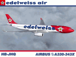
This is a re-upload. Due to the recent library "switch", my original posting was lost and I was asked to re-upload it. Anyway, I am proud to present this repaint of the Project Opensky A330-343X, registration HB-JHQ, of Edelweiss Air. This is Edelweiss Air's first A330-300. From its humble beginnings in 1995 with a single MD-83, Edelweiss Air has garnered accolades for its performance and customer service and is now a subsidiary of Lufthansa through its earlier acquisition by Swiss International Air Lines.
This repaint has many custom textures. All windows are hand-painted, 3D with window shades. The night windows textures and other night textures are custom as well. Engine textures, turbofans, fuselage shading and tail textures are all custom. Also, the wheels and tires are custom and hand drawn. The main gear wheels are as real as I could get them. All repainted textures in this package are 32-bit with no mipmaps for best clarity and quality. This is a complete installation package; version 2004.8.3 of the Project Opensky A330-300 V2 model and air files included. Uses default 737-400 panel and sounds.
| Filename: | Edelweiss_Air_Airbus_A330343X_HBJHQ.zip |
| License: | Freeware, limited distribution |
| Added: | 10th March 2011, 03:20:48 |
| Downloads: | 1,229 |
| Author: | Jeffrey S. Bryner, Project Opensky |
| Size: | 7.65 MB |
| Category: Flight Simulator 2004 - Aircraft Repaints, Textures and Modifications | |
| Air North 'Yukon Livery' Boeing 737-201 (C-GNAU) |
|
File Description:
I am proud to present this realistic, detailed repaint of Air North's Boeing 737-201, registration C-GNAU, in the newer "Yukon livery". This aircraft has a distinct orange tail with the name of the territory which gives this airline its name; Yukon. Air North is a Canadian Airline based in Whitehorse, Yukon, and is 100% owned by Yukoners. This project has been fun for a significant reason; the people of Air North. I contacted them with a request for their logos to use in this repaint, and they were gracious and professional in granting my request. So I dedicate this repaint to Air North their kind personnel; especially Josh Clark. For this as with all of the aircraft I paint, I paid attention to detail and realism as much as possible and generated this repaint with realistic but not overstated details. The textures in this repaint are 32-bit. All Air North logos used in this repaint are copyrighted property of Air North and are used on this repaint with permission from Air North. This is a textures only package; you must have the Tinmouse 737-200adv v2 base package available here at AVSIM.
| Filename: | Air_North_Yukon_Livery_Boeing_737201_CGNAU.zip |
| License: | Freeware, limited distribution |
| Added: | 22nd August 2008, 02:12:46 |
| Downloads: | 957 |
| Author: | Jeffrey S. Bryner | Tinmouse II Project |
| Size: | 8.85 MB |
| Category: Flight Simulator X - Miscellaneous Files | |
| FSX Metal GUI |
|
Images related to this file:
File Description:
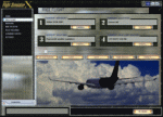
I designed this for myself to darken the default User Interface for 2 reasons. I have bad eyes that are sensitive to bright objects on the screen, and I like to fly the simulator in the evening hours with the lights turned off in the room. I hope you like my end result.
I also added 2 bonus features. Instead of hearing the Windows/Internet Explorer click sound when you mouse click on a menu item, you now will hear the "Fasten Seatbelts" sound effect. Be sure to back up the original sound "checkc" in case you find the new sound annoying. Secondly, I have included 4 optional Aircraft Viewer images that give the selected aircraft a more airborne look. I will make switching these simple by adding them to the Generic Mod Enabler(JSGME) that I will include in the download.
The look is created using Diamond Plate and Polished Aluminum textures, and modifying the buttons with some more color.
This is Freeware, and I am giving permission to anyone that wants to create their own and upload to any site they wish. I do not wish that you have to mention my name in any credits.
| Filename: | FSX_Metal_GUI.zip |
| License: | Freeware |
| Added: | 20th November 2011, 00:12:46 |
| Downloads: | 462 |
| Author: | Todd McCuistion |
| Size: | 7.83 MB |
| Category: Flight Simulator 2004 - Aircraft Repaints, Textures and Modifications | |
| US Air Metal Fuse BAC 1-11 204AF (N1127J) |
|
Images related to this file:
File Description:
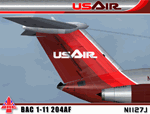
I am very proud to present this very detailed and realistic repaint of the BAC 1-11 204AF model by David Maltby in the classic US Air livery from the early 80's. This was one of the original jets flown by US Air. It flew side by side in their fleet with the B727, DC9 and 737-200. This repaint is the result of a major overhaul of the paintkit for this aircraft, and is very detailed and realistic. The many new details and hand repainted items include; custom metal fuselage, custom windows, custom tail textures, hand painted wheels, and also much needed night lighting and night textures. The US Air logo is also hand painted. All repainted textures in this package are 32-bit with no mipmaps. This repaint is dedicated to Lorne Jordan, a Canadian simmer who inspired this project and who helped Q/A this repaint so we didn't miss a detail. Thanks to the permission granted by of the gracious and talented David Maltby (creator of this aircraft model), this is a full installation package, complete with 2D panel, virtual cockpit and BAC 1-11 sounds. Please see README.TXT for installation instructions.
| Filename: | US_Air_Metal_Fuse_BAC_111_204AF_N1127J.zip |
| License: | Freeware, limited distribution |
| Added: | 5th May 2012, 07:36:27 |
| Downloads: | 851 |
| Author: | Jeffrey S. Bryner, Lorne Jordan, David Maltby |
| Size: | 21.41 MB |
| Category: Flight Simulator 2004 - Original Aircraft | |
| Lockheed C-130H |
|
File Description:
FS2004 Lockheed C-130H Hercules
This aircraft is built for FS2004. It should work with FS2002 without any problems, but I no longer support FS2002.
This package is configured with a default panel. It is intended for use with the custom panel made by Ken Mitchel. You must obtain the panel in a seperate download. If you have not done so, it is available on my site.
The base textures folder in this zip file contains base (unpainted) texture files for use in repainting.
Note that the aircraft supplied in this package is supplied as is. While I endeavor to correct problems with the aircraft, I make no guarantee that any problem real or perceived will be fixed. Suggestions for enhancements and fixes will be implemented solely at my discretion. Please don't waste my time with subjective "perceived" issues like "The nose is too round", "The tail is too small", "The wing is the wrong color", etc. I have made every effort to make the model as accurate as I am able and willing, and will not modify it further to fit anyone's personal specifications.
| Filename: | Lockheed_C130H.zip |
| License: | Freeware |
| Added: | 13th August 2003, 03:01:47 |
| Downloads: | 18,232 |
| Author: | Mike Stone |
| Size: | 450.79 KB |
| Category: Flight Simulator X - Scenery | |
| Oahu Scenery Version 1 |
|
File Description:
This scenery sits on top of "MegaSceneryX - Hawaii - Honolulu and Oahu Island", SO IT REQUIRES THE MEGASCENERY X - Hawaii - Honolulu & Oahu Island" photo scenery from http://www.megascenery.com/
This is primarily an Autogen scenery with some custom developed objects for the coast of Oahu.
I used autogens from default FSX for the most part as well as the FSX Acceleration. IF you did not install acceleration, it should not be an issue. you would just not see some of the autogens from the acceleration package. I have also included some custom built GMAX Objects with this package. There is also an AFCAD file for a new fictitious Heliport that is included ("PMMH)".
This scenery package also includes a Mission called "Oahu Sacred Falls Landing". It is a short mission without any surprises or twists, yet I am confident many of you would find it interesting and very very challenging. But do not be discouraged at the difficulty of completing the mission. You may want to turn off crash detection to make it easier if you'd like. The fun is in the journey..right?
Lastly, I have included a fix for my MM_PHNGv1 scenery as part of this package.
| Filename: | Oahu_Scenery_Version_1.zip |
| License: | Freeware, limited distribution |
| Added: | 29th February 2008, 02:31:04 |
| Downloads: | 4,127 |
| Author: | Manny Mahadevan |
| Size: | 9.9 MB |
| Category: X-Plane - Original Aircraft | |
| Boeing B314 Clipper for X-Plane 6.40/6.51 |
|
File Description:
Boeing B314 Clipper v1.0 for X-Plane 6.4/6.51- Built for Pan American Airways to expand their Clipper fleet, they also saw service for the US Navy and BOAC. The "clipper" name was appropriate because the Sikorsky S42, the Martin M130 (also available for X-Plane on AVSIM) and the Boeing B314 opened up long distance air lanes in 1930's and 40's the same way that the clipper ships opened up sea trade in the late 1800's. The model flies very well and is as accurate as the limited plans available to me. Due to limitations in shaping airfoils the outside rudders are actually engine nacelles (jets with 5 lb of thrust) and the lower wing is also an engine nacelle. The rear section of the fuselage is actually a gas tank or float section used to get better detail in the fuselage. As all of my models the exterior paint and panel can use a lot of work. What you see here is approximately 6-8 hours of modelling/decorating? work plus 16-20 hours or more of test flights.
Number built: total 12, 6 A314's built with upgraded engines and increased range
Engines: 4 - 1,600 HP, Wright R-2600, Twin Cyclone ,14 cylinder, air-cooled, radial engines. Wing Span: 152 ft. Length: 106 ft Max GW: 84,000 lb. Max level speed: 193 mph Cruising speed: 183 mph Range: 3,500 (5,200 A314) miles First flight: June 7, 1938, last retirement 1951. Ceiling: cruise 13,400, maximum 19,600 feet
Accommodation: 10 crew, 74 (36 night) passengers.
| Filename: | Boeing_B314_Clipper_for_XPlane_640651.zip |
| License: | Freeware |
| Added: | 12th February 2003, 22:41:20 |
| Downloads: | 639 |
| Author: | Robert App |
| Size: | 1.06 MB |
| Category: Flight Simulator 2004 - Scenery | |
| Shaktoolik 2C7 in Alaska |
|
Images related to this file:
File Description:
Shaktoolik is a coastal village 35 miles north of Unalakleet, with a fishing population of around 250. It was originally established inland on the Shaktoolik River but moved to the coast in 1933. Due to storms and erosion it was again moved in 1967, to its current location 2 miles further north. Confusingly, what is called "New Shaktoolik 38A" was in fact only "new" in 1967 and has since been replaced by "Shaktoolik 2C7" further north, built on wider land with a longer gravel runway of 4,000 feet. 38A is still visible but unusable, with the sheds being used for other purposes. There are flights from Unalakleet, included in the AI here as a further modification to the Bethel PABE AI. A note here about my scenery making. This is post number 500 and there will not be many more to follow this as I am almost at the end of the photos I either took or found for scenery purposes. There is a limit to what can be located online and I have already been making use of the little there is; eg Unalakleet. So, if you are near an airport (preferably Canadian or Alaskan) and have a camera..... Let me know.
| Filename: | Shaktoolik_2C7_in_Alaska.zip |
| License: | Freeware, limited distribution |
| Added: | 27th July 2019, 21:00:56 |
| Downloads: | 107 |
| Author: | Roger Wensley |
| Size: | 4 MB |
| Category: Prepar3D V1-4 - AI Flight Plans | |
| Nomads Travel Club 1998 |
|
File Description:
Nomads Travel Club may be one of the most storied travel clubs in aviation history. Founded in 1961 and based in Detroit(DTW), where the airline had it's own terminal, Nomads Travel Club gave up to 10,000 adventurous members the opportunity to hop on aircraft for elaborate tours across the earth. Initially flying a DC-7C, the airline upgraded to a L-188 Electra, CV-990, 727-100, and finally 727-200 N727M in 1993 which served the club until it's demise in 2011. N727M has traveled to dozens of countries and hundreds of airports, and I was able to find good information about 2 tours flown in 1998 and represented them in these plans. The aircraft spends at least half a day at each destination except for YHZ which is just a Westbound refueling stop. As far as I could find, the airline had no callsign or codes, so I am guessing they used the registration as a callsign. There is a paint for the AIA 727-200 on Avsim as "aib722nomads.zip".Flightplans by Chasen Richardson, based on real tours flown in 1998. Part of the 1998 Flight Simulator Project. Follow us on Facebook at facebook.com/flightsim98 and on instagram as @bayviationsim. For more Retro AI, check out the forums at: http://retroai.proboards.com/
| Filename: | Nomads_Travel_Club_1998.zip |
| License: | Freeware, limited distribution |
| Added: | 2nd December 2019, 14:26:43 |
| Downloads: | 60 |
| Author: | Chasen Richardson\Bayviation |
| Size: | 747.92 KB |
| Category: Flight Simulator X - Aircraft Repaints, Textures and Modifications | |
| Modification of the power table for the Continental IO-520-F Cessna CU206G Stationair 6 II de CARENADO. |
|
Images related to this file:
File Description:

New update of flight dynamics settings.
Corrected the indicated speed error (KIAS) vs the true speed (KTAS) according to the data suggested in the pilot's operating manual (POH).
In some cases the position of the center of gravity unladen weight is corrected for a better weight and balance of the airplane.
Actual direct references from Pilot Operations Manual (POH) for specific details, Power,
Nose or pitch position and weight and balance settings, airplane geometry, piston or turbine engine data,
propeller and everything that refers to references, also the real references of the manufacturers of sea engines whatever the specific case.
This model in particular, I am sure that the gauges have a difference error between what the indicator of
manifold pressure and actual airplane reading, similar case to the PA34 Seneca II, the RPM tachometer needle marked 2500 and the
Maus cursor on the tachometer said there were 2200 rpm.
In this modification of the Cessna CU206G Stationair 6 II there is still an error that could not be adjusted to what it says in manual
pilot operation (POH) because it is a gauge error and not an adjustment error in the .air file.
When the error is corrected it will be published together with a new and improved VC.
| Filename: | Modification_of_the_power_table_for_the_Continenta.zip |
| License: | Freeware |
| Added: | 15th April 2020, 18:48:28 |
| Downloads: | 147 |
| Author: | Rafael Ledezma |
| Size: | 642.83 KB |


© 2001-2026 AVSIM Online
All Rights Reserved
Privacy Policy |