
Where Flight Simulation Enthusiasts Gather from Around the World!
AVSIM Library - Search Results

| Category: Flight Simulator X - AFCAD Files | |
| Malone Airport (NJ61), NJ |

|
File Description:
Located 02 miles E of Frenchtown, New Jersey on 45 acres of land, Malone is a private airport with two turf strips, the longest of which is 2400' in length. There are no services offered, although there is room next to the existing planes to park if you wish - collisions are disabled with the aircraft. Both runways have their hard surfaces removed so turn your mesh settings as high as possible. Both runways slope down from the hangar/house area. Airport is unlit and daytime VFR operations only are recommended.
Scenery constructed with use of satellite images/streetview/aerial photos - the author has not been there in person.
This scenery is meant to be used in conjunction with MegaScenery Earth New York 007. It is not required, but apron use is minimized to allow satellite scenery to show through as much as possible, and objects are placed based on the MSE textures - lack of it may make scenery look out of place.
| Filename: | Malone_Airport_NJ61_NJ.zip |
| License: | Freeware |
| Added: | 20th September 2011, 13:57:18 |
| Downloads: | 284 |
| Author: | Drew Sikora |
| Size: | 958.34 KB |
| Category: Flight Simulator 2004 - Scenery | |
| Airstrips east of the Alps |
|
File Description:
A collection of over 70 small airfields in Hungary, Slovakia, Slovenia and Croatia, many of which aren't featured in FS2004, each enhanced with taxiways, parking spaces, buildings etc. and aprons as appropriate, to fill in a few gaps to the north-east of Italy and to allow the generation of lightweight GA AI traffic in this area and into the adjacent countries.Again, there's no photo-realism here, just a selection of basic 'generic' buildings, more or less accurately sized and placed to reflect the airfield layout as seen on on-line satellite imagery and aerial photography. These buildings have minimal effect on frame-rates, so are ideal for this kind of job. The airfields are aligned as well as possible with the roads etc. in UT Europe, where applicable, and the Genesis Europe mesh, but should mostly be fine in a default installation or other configuration.
| Filename: | Airstrips_east_of_the_Alps.zip |
| License: | Freeware |
| Added: | 12th September 2025, 13:29:14 |
| Downloads: | 58 |
| Author: | Chris Eve |
| Size: | 785.49 KB |
| Category: Flight Simulator X - AFCAD Files | |
| Var-Sky Airport (JY08), NJ |
|
File Description:
Located 02 miles E of Woodstown, New Jersey on 38 acres of land, Var-Sky Airport is a private turf strip 1165' in length and a slightly challenging approach with trees closely bordering the sides of both runway ends. This airport has lighting on the runway however there is no beacon and the windsock (located atop the hangar) is not lit. There are no services offered for transient aircraft. There is no hard surfaced runway so having your terrain mesh settings as high as possible is recommended.
Scenery constructed with use of satellite images/streetview/aerial photos - the author has not been there in person.
This scenery is meant to be used in conjunction with MegaScenery Earth New Jersey/Delaware 004. It is not required, but apron use is minimized to allow satellite scenery to show through as much as possible, and objects are placed based on the MSE textures - lack of it may make scenery look out of place.
| Filename: | VarSky_Airport_JY08_NJ.zip |
| License: | Freeware |
| Added: | 19th April 2011, 06:21:50 |
| Downloads: | 195 |
| Author: | Drew Sikora |
| Size: | 361.96 KB |
| Category: Flight Simulator 2004 - Scenery | |
| Ontario Small Fields in Canada: #04 Stoney Point (Le Cunff) CRML V1 |
|
Images related to this file:
File Description:
This is the fourth in a series of small airfields in southern Ontario, Canada. It is Stoney Point (Le Cunff) CRML, a field near a small town (Stoney Point) close to Lake St Clair. The airfield has a grass runway of 2,250 feet, aligned 18/36; with trees around the house gardens between road and runway the south threshold is displaced by 250 feet. The markers approximately show the touchdown point north of the runway end. Le Cunff is the family name of the owners, included to differentiate between this and another Stoney Point field, CRJ2. I found the default FS9 airfield at the correct elevation of 625 feet, but sitting on a plateau, despite my Genesis Mesh. This looked so unreal that I have revised this to an incorrect lower elevation of 580. So if you find the airfield sitting in a hole in your installation you now know the reason. Let me know, with a screenshot please.
| Filename: | Ontario_Small_Fields_in_Canada_04_Stoney_Point_Le_.zip |
| License: | Freeware, limited distribution |
| Added: | 29th July 2015, 16:08:32 |
| Downloads: | 146 |
| Author: | Roger Wensley |
| Size: | 1.6 MB |
| Category: Flight Simulator 2004 - Scenery | |
| Canlaon Volcano Eruption Scenery |
|
File Description:
Canlaon Volcano is located at the center of Negros Island,Philippines.The twin-peaked massif of Canlaon Volcano (aka Mt. Kanlaon) rises 2,465 meters above the island of Negros just 40-km southwest of the capital Bacolod.This file will add the crater to Canlaon Volcano and will enhance the Landclass surrounding the crater.The crater is real with water.This also adds Visual Effects such as steam,volcanic ashes and lava that will erupt every now and then.Ash falls will fall in the vulnerable surrounding villages of Pula, Malaiba, and Lumanao.The last volcanic activity of Canlaon Volcano recorded by Phivolcs was on June 1-18,2003.
Fly from Bacolod City(RPVB)to Tagbilaran City(RPVT)or Mactan(RPVM) and pass through the highest point of the Island of Negros and behold the beauty of the Canlaon Volcano eruption.
Special steam,ash,and lava effects are visible at daytime and at nighttime.The new Philippine Mesh by Jacques Marie is recommended for achieving realistic topography.You may find it here at avsim,too.
| Filename: | Canlaon_Volcano_Eruption_Scenery.zip |
| License: | Freeware |
| Added: | 10th December 2003, 22:41:38 |
| Downloads: | 3,877 |
| Author: | Ver Walter L. Gulfan |
| Size: | 5.04 KB |
| Category: Flight Simulator 2004 - Scenery | |
| Bora Bora Airport, French Polynesia, NTTB |
|
File Description:
The Bora Bora airport is located on one of the Motus, which surround the Island of Bora Bora. The Motus are raised coral reefs which act as break waters, and create the beautiful turquoise lagoons which surround the French Polynesian Islands. This scenery is a complete remake of the original, and is now much more accurate as to what the airport looks like. It contains the main terminal, a fire station attached to the tower with fuel tanks, open air hangar structures, two helipads, and wood stairs taking you down to the boat docks where you are transported to the main island. This is one of the most unique French Polynesian Islands with it's beautiful and interesting mountain structure. Using the terrain mesh by Rolf Keibel and John Applegate will tremendously enhance this part of the world in FS. It is available at Flightsim under the name fpsimesh.zip. Afcad by Ray Smith is also included.
| Filename: | Bora_Bora_Airport_French_Polynesia_NTTB.zip |
| License: | Freeware |
| Added: | 25th April 2004, 01:39:17 |
| Downloads: | 19,361 |
| Author: | Bill Melichar |
| Size: | 3.11 MB |
| Category: Flight Simulator 2004 - Scenery | |
| Exploring Our World - Part 1. Canaima Park - Canaima Airport (SCVN) - Angel Falls, Venezuela |
|
Images related to this file:
File Description:

Exploring Our World - Part 1. Canaima Park - Canaima Airport (SCVN) - Angel Falls, Venezuela. Visit the worlds highest waterfall (16 times higher than Niagara) - one of the Natural Wonders of the World!
This new package features David Maldonado's excellent Mesh of Canaima Park in Venezuela and a very special "animated" depiction of Angel Falls by Ron Jeffers. The Canaima Airport has been enhanced using EZ Scenery libraries. There is also an optional Lago sound file created by Lou Frost. A brief history of Angel Falls along with a suggested tour of the area is included. You will also find a flight plan for use with the FSNavigator program. This is the first of a projected series exploring lesser known parts of our FS world. Please unzip (using folders option) to a temporary folder and follow the instructions very carefully.
This project was compiled for your flying enjoyment by David "Opa" Marshall.
| Filename: | Exploring_Our_World__Part_1_Canaima_Park__Canaima_.zip |
| License: | Freeware |
| Added: | 31st October 2009, 10:36:18 |
| Downloads: | 3,260 |
| Author: | David "Opa" Marshall |
| Size: | 3.22 MB |
| Category: Flight Simulator X - Scenery | |
| Los Roques Archipelago and Airports |
|
Images related to this file:
File Description:
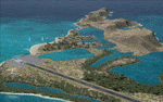
This project rebuilds Venezuela's Los Roques archipelago, adds the Gran Roque (SVRS) and Dos Mosquises (SVDM) airports, and includes AI flight plans, boat traffic, and a custom terrain mesh for Gran Roque. Accurate coastlines and lakes, as well as corrected landclass and waterclass are provided based on the latest available satellite imagery. Although current satellite imagery for this region only exists in relatively low resolution, an abundance of aerial photography was used to add custom features to Gran Roque and Dos Mosquises. Updates were created or rebuilt in a manner which carefully aligned airport data with current satellite imagery, when available. Scenery was created using Airport Design Editor X v1.50.4402, SBuilderX 3.13, and the FSX Object Placement Tool. Scenery objects were added and modified from stock FSX scenery to resemble as closely as possible the actual airports. Thank you to John Hinson and Tiago Besciak for granting permission to adapt their AI flight plans to realistically populate (SVRS) Gran Roque.
| Filename: | Los_Roques_Archipelago_and_Airports.zip |
| License: | Freeware |
| Added: | 27th July 2013, 02:34:10 |
| Downloads: | 1,399 |
| Author: | Carlyle Sharpe |
| Size: | 7.66 MB |
| Category: Flight Simulator X - Scenery | |
| 70 Colombia Airports |
|
File Description:
70 Colombia airports/airfields for FSX. Mainly based on GoogleEarth. Changes to default airports and many new airports added. Largely based on my formerr FS9 colombian airport sceneries. I am using the FreeMesh X Global 1.0 from https://www.avsim.com/forums/topic/467933-freemesh-x-global-10-release-announcement/ but most sceneries should work also with the default or any other mesh. All files start with the ICAO identifier of the airport; so you can take out what you don't like or use only what you like.
Airports included are: ACM (IATA Code), SK53,SKAG,SKAO (now SKMJ) SKAS, SKBC, SKBE, SKBM, SKBN, SKBQ, SKBS, SKBU, SKCA, SKCB, SKCI, SKCN, SKCR, SKCZ, SKEB, SKFE, SKFL, SKGA, SKGI, SKGY, SKHA, SKHC, SKIB, SKIM, SKIO, SKIR, SKLA, SKLB, SKLC, SKLP, SKLT, SKMF, SKMG, SKMO, SKMO, SKNA, SKNV, SKOE, SKOT, SKPA, SKPD, SKPI, SKPP, SKPV, SKPZ, SKQU, SKRI, SKSA, SKSF, SKSJ, SKSV, SKTB, SKTM, SKTQ, SKUA, SKUM, SKUR, SKVG,
SLVP, SQFR, SQOA, SQPS, SQUJ, SQVZ, Z09A
| Filename: | 70_Colombia_Airports.zip |
| License: | Freeware |
| Added: | 6th January 2019, 17:39:01 |
| Downloads: | 2,433 |
| Author: | Detkev J. Rohmer |
| Size: | 106.4 MB |
| Category: Flight Simulator 2004 - Scenery | |
| Airstrips of Poland |
|
Images related to this file:
File Description:
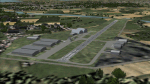
Expanding my horizons from Western Europe, herewith about 70 small airfields in Poland, many of which are not included in FS2004, each enhanced with taxiways, parking spaces, buildings etc. and aprons as appropriate, to further facilitate the generation of lightweight AI traffic in the area, without overloading the more major airfields.
Again, there's no photo-realism here, just a selection of basic 'generic' buildings, more or less accurately sized and placed to reflect the airfield layout as seen on on-line satellite imagery and aerial photography. These buildings have minimal effect on frame-rates, so are ideal for this kind of job. The airfields are aligned as well as possible with the roads etc. in UT Europe and the Genesis Europe mesh, but should mostly be fine in a default installation or other configuration.
Please read the rest of this "blurb" in the included text file. There may be some details of note or interest.
| Filename: | Airstrips_of_Poland.zip |
| License: | Freeware |
| Added: | 21st January 2025, 15:58:08 |
| Downloads: | 110 |
| Author: | Chris Eve |
| Size: | 650.89 KB |


© 2001-2026 AVSIM Online
All Rights Reserved
Privacy Policy |