
Where Flight Simulation Enthusiasts Gather from Around the World!
AVSIM Library - Search Results

| Category: Flight Simulator 2004 - Scenery | |
| Nome PAOM on the northwestern coast of Alaska |

|
Images related to this file:
File Description:
There are four main northwestern Alaska towns which have good airports and are serviced by Alaska Airlines. From these airports local flights connect to nearby villages, "nearby" in Alaska meaning up to 200 miles away. The northernmost is Barrow. Southwest of Barrow is Kotzebue, then Nome, and the furthest south is Bethel. The town of Nome is south of the Bering Strait on the southern coast of the Seward Peninsula, around 185 miles south of Kotzebue, with a population of about 3,800. It is the town that led to the creation of the most famous dogsledge race in the world, the Iditarod, which is based on the delivery to Nome of diphtheria serum during the blizzard conditions of the winter of 1925. The Nome airport (it currently has no other name) was originally built as the last of the refuelling airfields for planes being ferried to Russia during WW2. It has two runways, aligned 09-27 and 02-20 in FS9 (the wandering magnetic north has recently renamed the magnetic headings) and both of them around 6,000 feet with an ILS on 27. There is a modern airport layout diagram included showing taxiway names etc. Alaska Airlines, ERA, and Bering Air (which is headquartered in Nome), along with the shared cargo terminal for Northern Air Cargo and Everts Air, are all on the southern apron. The northern apron is mainly for GA, along with maintenance facilities, a garage building that also houses a weather bureau, and at the far northern end of runway 02-20 an apron and hanger for the Alaska Air National Guard. All AI aircraft in FS9 much prefer to use a runway that has an ILS and so will continue to use 09-27 even if the wind is from the north or south, right up until it reaches 30+ knots, so for AI realism in FS9 a permanent wind from the west would be the most realistic on a daily basis. There is also a small gravel strip just north of the town and this is included (94Z), as are some old line-of-sight radio communication reflectors on the hills above the town. There is a note about making adjustments to Ultimate Terrain Alaska-Canada regarding both realistic road lighting and also auto-generation.
| Filename: | Nome_PAOM_on_the_northwestern_coast_of_Alaska.zip |
| License: | Freeware, limited distribution |
| Added: | 18th October 2016, 02:38:42 |
| Downloads: | 486 |
| Author: | Roger Wensley |
| Size: | 22.65 MB |
| Category: Flight Simulator 2004 - Scenery | |
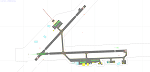
| Kotzebue PAOT on the northwestern coast of Alaska |
|
Images related to this file:
File Description:
There are four main northwestern Alaska towns which have good airports and are serviced by Alaska Airlines. From these airports local flights connect to nearby villages, "nearby" in Alaska meaning up to 150 miles away. The northernmost is Barrow. Southwest of Barrow is Kotzebue, then Nome, and the furthest south is Bethel. The town of Kotzbue is north of the Bering Strait on the northwestern coast, 320 miles southwest of Barrow. The population is just over 3,000 people. The location was for a long time a base for trading in furs, with three rivers emptying into the sea and providing routes into the interior land and villages; a meeting place between hunters and traders from Russia and elsewhere. The Kotzebue airport is called the Ralph Wien Memorial and has two runways. The modern one is aligned 08-26 and is 5,880 feet of 150 feet wide asphalt built across a shallow lagoon, with an ILS on 08 and PAPI on both ends. The second and older runway is originally military and gravel, aligned 17-35 and 3,786 feet long and used (wind allowing) by the GA planes that park alongside the runway. The prevalent wind is from the west; when the wind is from the east it is generally relatively feeble and with a much lower cloud base, possibly to the ground, hence the need for an ILS. All AI aircraft in FS9 much prefer to use a runway that has an ILS and so will continue to use 08-26 even if the wind is from the south until it reaches 30+ knots, even if they are a Cessna 150 flying VFR. So for AI realism in FS9 a northern or southern wind needs to be a strong one so that the runway is actually used. However, as Alaska Airlines, Northern Air Cargo, and Everts Air also fly to Kotzebue and can only use the east-west runway (as less than 4,000 feet of asphalt would be seriously inconvenient for a Boing 737 or DC6) it is necessary to have the northern or southern wind UNDER 30 knots at the times when they are landing or taking off. Your choice. I suppose a permanent strong wind from the west would be the most realistic on a daily basis, deterring all planes from ever using 17-35. The AI will develop along with further scenery additions in the neighbourhood.
| Filename: | Kotzebue_PAOT_on_the_northwestern_coast_of_Alaska.zip |
| License: | Freeware, limited distribution |
| Added: | 2nd August 2016, 16:47:52 |
| Downloads: | 458 |
| Author: | Roger Wensley |
| Size: | 19.32 MB |
| Category: Prepar3D V1-4 - Utilities | |
| Random Flight Database 2.1.9 |
|
File Description:
Random Flight Database is a program that will allow you, depending on one or more criteria, to choose a flight corresponding to existing flights.
These flights are extracted from a database of 1,262,465 lines, available in the program. This database is updated in summer 2019.
You also have a user base that will allow you to share your data files (.XLS) between users to add even more choices.
Part of it is also dedicated to importing data from the website: https://developer.flightstats.com/
You must create an account on this site in order to extract (limited to about 6 airports in total for 1 account)
This import is made 7 days from the moment you make this import.
Once this import is done, you can import it directly into your user database and / or export it in XLS format for sharing with other users.
Files are available for free on the org.
The criteria for choosing your flights are:
- Airlines
- Departure airport
- Arrival Airport
- Type of plane
- Day of the week
- Multiple generation (generates a number of flights determined by the user)
- flight time (choice of a flight time interval, minimum flight time
| Filename: | Random_Flight_Database_219.zip |
| License: | Freeware |
| Added: | 2nd September 2019, 22:25:07 |
| Downloads: | 86 |
| Author: | mikoulprostgrandprix |
| Size: | 80.46 MB |
| Category: Flight Simulator X - AFCAD Files | |
| Greater Moncton International Airport / Canada (CYQM) |
|
Images related to this file:
File Description:
CYQM - Greater Moncton International Airport / Moncton, New Brunswick, Canada
This airport update was made with the latest version of ADE (Airport Design Editor) and made for FSX as a replacement for the stock (default) airport. I found that most stock airports in FSX lack a decent amount of character and realism and this area in particular was dreadful! The stock airport was rather inaccurate. I've made several additions to the airport which are listed below. All these enchancements are as close to the real airport as I can get with stock library objects. I've used satellite images, terminal photos and maps throughout the whole process so building locations are as accurate as possible. Happy landings in the beautiful Canada!
Features:
*Expanded parking apron
*Main terminal building with it's 2 jetways and additional parking for regional jets/turboprops
*Seperate parking aprons for GA traffic near the old terminal
*Hangar and other airport buildings added
*Airport vehicles and objects throughout the airport
*Main road in front of airport added with static vehicles
*Parking lots with static vehicles
*Airport fire station with fire trucks
*Static de-icing vehicles
| Filename: | Greater_Moncton_International_Airport__Canada_CYQM.zip |
| License: | Freeware |
| Added: | 21st July 2012, 02:41:58 |
| Downloads: | 815 |
| Author: | Jaison Diaz |
| Size: | 10.6 KB |
| Category: Flight Simulator X - Missions | |
| Flight to Area 61 |
|
File Description:
Captain Igor Kringbrinsky of the "Special Air Service" will be piloting flight XX-C4 to " Special Area-61"
better known to pilots as " No-whereland".
As usual he is being moved to the base at the Ust-Kamenogorsk Airport (UASK) three days before the
flight. Using an old ANT-2 he will carry electronic supplies(????) and will also pickup on the way to the
different locations (To be known only before the flight) special personnel that work in these places and
who are coming out for vacations.
As co-pilot you will have to check the plane before the flight and since on this flight you are to be rated,
previous to becoming pilot-in-command for future flights, you will do all take offs and landings.---Carefully
study the maps given to you for the " secret" locations you will land before you reach Area 61.
These "locations" may be on "Roadways", mountains, valleys and even large airports-----
Sorry to say, the Weather this time of the year is "stormy and rain, thunder and high winds may be
expected....This is a hard Mission.
| Filename: | Flight_to_Area_61.zip |
| License: | Freeware, limited distribution |
| Added: | 21st April 2008, 09:42:55 |
| Downloads: | 2,853 |
| Author: | Gera Godoy Canova |
| Size: | 5.93 MB |
| Category: Flight Simulator 2004 - Aircraft Repaints, Textures and Modifications | |
| Air Iceland/Flugfelag Islands Bombardier Dash-8-106 (TF-JMB) |
|
Images related to this file:
File Description:
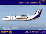
Here's another Dash-8 especially for the Icelandic simmers out there or those who prefer the challenge of simming the skies and airports of the northernmost latitudes. This is one of two (2) Dash 8-106's flown by Air Iceland (Icelandic: Flugfelag Islands) and bears registration TF-JMB. Flugfelag Islands, a subsidiary of Icelandair Group, is a regional airline with bases at Reykjavik Airport and Akureyri Airport. It operates scheduled service to destinations in Iceland and Greenland, as well as the Faroe Islands. I want to give due credit to and thank Elmar Voigt, who inspired this project and repaint and worked with me to get every detail of it as realistic as possible. Some of those details include the text 'flugfelag.is' on the bottom of the fuselage (just like the real aircraft) and a tug painted in Air Iceland/Flugfelag Islands colors with their logo on the doors. All repainted textures in this package are 32-bit with no mips for maximum quality. This is a textures only package; you must have the Dreamwings Design Dash8 Q-100 model available here at AVSIM.
| Filename: | Air_IcelandFlugfelag_Islands_Bombardier_Dash8106_T.zip |
| License: | Freeware, limited distribution |
| Added: | 29th June 2010, 02:25:57 |
| Downloads: | 1,041 |
| Author: | Jeffrey S. Bryner, Elmar Voigt, Dreamwings Design |
| Size: | 3.21 MB |
| Category: Flight Simulator 2002 - Aircraft Repaints, Textures and Modifications | |
| FS2002 Val-U-Prop Plane and Panel |
|
File Description:
FS2002 Val-U-Prop Douglas DC-3 Plane and Panel
Val-U-Prop is a (fictional) rogue airline based in Bloomington, Indiana, that flies everything from VIPs to sheep manure anyplace and anytime. VP's motto is "No job too small; No fee too large," and our DC-3's and DC-6's can be seen hedge-hopping into various obscure airports throughout the USA. Based on the lovely DC-3 Pluna by Daniel Gazzano, this aircraft is a re-paint of the fabulous DC-3 OH-LCH by Jan Visser, Erik Ellis, Roy Chaffin, Ian Roper and Bill Rambow, to which FS2002 lights have been added. Panel includes everything on main panel, except for GPS, so there is no tabbing. (Default pop-up radio stack is also included.) Panel is based on photographs by Bill Blanchard (lower panel) and Shawn Clark (upper). The very aluminal wing views were shot by Thomas Andre Hjelmen, and the 1930s cabin was photographed by Ben Wang and is populated with various VIPs. All of this brought to you by Val-U-Prop - where WE VAL-U-YOU! By James Underwood
| Filename: | FS2002_ValUProp_Plane_and_Panel.zip |
| License: | Freeware, limited distribution |
| Added: | 26th February 2003, 16:36:44 |
| Downloads: | 600 |
| Author: | James Underwood |
| Size: | 6.2 MB |
| Category: Flight Simulator 2004 - Miscellaneous Files | |
| Active ILS - Niagara International Airport KBUF |
|
File Description:
As most know initiating the ILS at certain airports for AI Aircraft or User Planes is not a function at this time when using AFCAD2 if visibilty falls below 3 miles. This is do to the somewhat complex XML code that has to be written for NAVAIDS and then the compiling into a bgl file. If you add a new ILS runway to an airport such as KBUF (rwy 32) only the user aircraft can use this runway when visibility falls below 3 miles if a GPS/LDA is unavailable. ATC will no longer use 32 ILS runway for AI Traffic or User Aircraft (by default) because FS9 sees it as a visual runway and will now vector your Planes back to 5/23 ILS which is also being used as a Terminal Departure Runway. The KBUF_ILS_jv.bgl file adds all NAVAIDS for making 32 a Precision Instrument Runway by adding all the radar fixes for both the ILS/DME approach portion and the proper missed approach procedures as per current published plates for runway 32. See the readme for what's new at the KBUF airport. **** AFCAD2 included for FS9 default scenery. ****
| Filename: | Active_ILS__Niagara_International_Airport__KBUF.zip |
| License: | Freeware, limited distribution |
| Added: | 30th January 2005, 17:21:34 |
| Downloads: | 1,306 |
| Author: | Jim Vile |
| Size: | 117.25 KB |
| Category: Flight Simulator 2004 - Miscellaneous Files | |
| Active ILS - KLAS (McCarran Intl - Las Vegas, Nevada) |
|
File Description:
As most know initiating the ILS at certain airports for AI Aircraft or User Planes is not a function at this time when using AFCAD2 if visibilty falls below 3 miles. This is do to the somewhat complex XML code that has to be written for NAVAIDS and then the compiling into a bgl file. If you add a new ILS runway to an airport such as KLAS (rwy 01L) only the user aircraft can use this runway when visibility falls below 3 miles. ATC will no longer use 01L ILS runway for AI Traffic or User Aircraft (by default) because FS9 sees it as a visual runway and will now vector your Planes back to rwy 7/25LR ILS which is also being used as a Terminal Departure Runway. The KLAS_ILS_jv.bgl file adds all NAVAIDS for making 01L a Precision Instrument Runway by adding all the radar fixes for both the ILS/DME approach portion and the proper missed approach procedures as per current published plates for runway 01L. See the readme for what's new at the KLAS airport. **** AFCAD2 included for FS9 default scenery. ****
| Filename: | Active_ILS____KLAS__McCarran_Intl____Las_Vegas_Nev.zip |
| License: | Freeware, limited distribution |
| Added: | 28th February 2005, 15:44:40 |
| Downloads: | 3,026 |
| Author: | Jim Vile |
| Size: | 33.84 KB |
| Category: Flight Simulator 2004 - Scenery | |
| North Haledon Lite |
|
File Description:
This is Chopper Friendly scenery, folks. It wasn't designed to be flown over at 10,000 feet - although, if you like to fly heavy iron into the major New York/New Jersey airports, you'll notice that it replaces the terrain elevation of Northern New Jersey with all the hills and valleys that the default scenery left out. No, this is interactive scenery. Built to be explored low and slow.
Want to perfect your landing skills in a huge playground of rooftops, irregular terrain, and tight spaces? This is the place. You won't find any unlandable surfaces or false crashes here - just hundreds of places to touch down ranging from beginner, through expert, to downright sick!
This is the lite version, designed for people who are having trouble with the frame rates of the full version. I've thinned out the houses and trees, and removed the buildings South of Oldham Pond - but managed to keep most of the interesting places to land. In the tests I've done, there was about a 20 percent frame rate increase on average compared to the full version, with nearly a 45 percent increase in the most framerate-hostile areas.
| Filename: | North_Haledon_Lite.zip |
| License: | Freeware, limited distribution |
| Added: | 1st June 2006, 04:48:01 |
| Downloads: | 656 |
| Author: | Mick Posch |
| Size: | 11.38 MB |
© 2001-2026 AVSIM Online
All Rights Reserved
Privacy Policy |