
Where Flight Simulation Enthusiasts Gather from Around the World!
AVSIM Library - Search Results

| Category: Flight Simulator X - Scenery | |
| KHOT - Memorial Springs Airport - Arkansas, USA |

|
Images related to this file:
File Description:
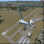
This scenery is an ADE update of the layout at Memorial Springs Airport in Arkansas, USA. This includes, updated parking spots, Adjusted Runway positions and length, Taxiways edited and Added, added buildings, relocation of some objects such as the ILS Transmitter for Runway 23/05 and The VOR, Checkershed and much more. I've tried to make this scenery as realistic as possible with the resources I have. If you have any contributions (e.g. pictures of the Airfield) please don't hesitate to contact me so I can update the Scenery. This is effectively version 1.0 of the scenery. Tested with FSX w/ SP2.
| Filename: | KHOT__Memorial_Springs_Airport__Arkansas_USA.zip |
| License: | Freeware |
| Added: | 23rd November 2015, 14:34:53 |
| Downloads: | 252 |
| Author: | Morgan Thomas |
| Size: | 3.96 MB |
| Category: Flight Simulator 2004 - Aircraft Repaints, Textures and Modifications | |
| AERO HOLLAND Cessna T-50 Bobcat |
|
Images related to this file:
File Description:
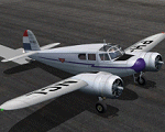
Re-release of the original repaint due to the loss of the file in the AVSIM hacking mishap.
The Dutch aviation pioneer Frits Diepen started the first charter and air taxi company in Holland shortly after WW2. This company was split into a maintenance section (AVIO-DIEPEN) and an airline section called AERO-HOLLAND. Home base was the airfield of Ypenburg, just outside The Hague. Besides other aircraft AERO-HOLLAND had 6 smaller Cessna T-50 Bobcats to perform short to medium haul charter flights. This repaint represents Bobcat: PH-NCL.
The Bobcat is now offered as freeware model by AlphaSim.
| Filename: | AERO_HOLLAND_Cessna_T50_Bobcat.zip |
| License: | Freeware |
| Added: | 8th December 2009, 00:57:13 |
| Downloads: | 606 |
| Author: | Jaap de Baare |
| Size: | 2.55 MB |
| Category: Prepar3D V1-4 - Scenery | |
| LOGO-Airport |
|
Images related to this file:
File Description:
![]()
The Civil Aerodrome LOGO is located in Niederöblarn, about 30 kilometers
east of Schladming, Styria. Since 2001, there is also a heliport located on the site of the airport (ICAO code:
LOGC). It is base to the crew of the Christophorus 14 rescue helicopter which is now fully functional.
This airfield is transfered, with kind permission from Mr. Gerhard Scholz, from his x-plane Version with ADE.
have a look on his homepage http://www.x-plane.at. Thank you to Manuel Bartl for his restless Beta Testing the new Version.
This scenery is compatible with "Austria Professional HD"
| Filename: | LOGOAirport.zip |
| License: | Freeware |
| Added: | 15th November 2017, 14:29:56 |
| Downloads: | 779 |
| Author: | Karl Malle |
| Size: | 17.02 MB |
| Category: Flight Simulator 2004 - Scenery | |
| Reichenbach LSAZ |
|
File Description:
The virtual airfield includes several buildings such as a hangar, a restaurant, a club house, military shelters, a playground and stationary cars. The surrounding area of Reichenbach has been populated with autogens: From the lake of Thoune down to Gemmi pass South of Kandersteg, and up until Adelboden to the West. Moreover, there is a high-voltage power line from Gemmi pass to the Gürbe valley, which should help during visual flight.
The scenery has been designed in Gmax and optimized for the mesh of Switzerland Professional. In order to save system performance, a series of LODS have been created.
| Filename: | Reichenbach_LSAZ.zip |
| License: | Freeware |
| Added: | 20th January 2006, 04:36:22 |
| Downloads: | 4,238 |
| Author: | Michael Röthlisberger |
| Size: | 2.95 MB |
| Category: Flight Simulator X - Aircraft Repaints, Textures and Modifications | |
| Tatenhill Aviation " Winnie the Pooh " Piper PA 28 Archer II G-TALE |
|
Images related to this file:
File Description:
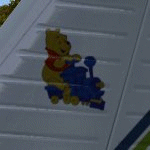
Repaint for the Carenado Archer II. This is my rendition of G-TALE ���¢�������� Winnie the Pooh ���¢�������� as flown by Tatenhill Aviation based at ( former RAF ) Tatenhill airfield ( EGBM ) UK .
Further repaints of their fleet will follow .
BMP and DDS textures are supplied as are thumbnails for FSX with full instructions to install . FS9 compatible.
| Filename: | Tatenhill_Aviation____Winnie_the_Pooh_____Piper_PA.zip |
| License: | Freeware |
| Added: | 30th October 2011, 21:07:35 |
| Downloads: | 153 |
| Author: | John Glanville / Carenado |
| Size: | 15.19 MB |
| Category: Flight Simulator 2004 - Scenery | |
| SBRF - Recife International Airport - Recife, Brazil |
|
Images related to this file:
File Description:
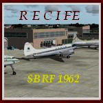
We have produced this scenery to provide taxiways and details
as they were around 1962 in Recife
We have also included new parking to allow the AI aircraft to taxi
correctly at the new (old!) airport.
Originally called Ibura Airport, the airport had its name changed to Guararapes Airport in 1948. The facility originated at the time of World War II, when a new airport was built to replace the earlier airfield, Parque do Encanta Moça. With the end of the War, the facility became strategically important as a technical and refueling stop on the route from South America to Europe.
| Filename: | SBRF__Recife_International_Airport__Recife_Brazil.zip |
| License: | Freeware, limited distribution |
| Added: | 31st May 2016, 16:26:46 |
| Downloads: | 791 |
| Author: | Wolfgang Gersch, Harry Biard |
| Size: | 4.42 MB |
| Category: Flight Simulator X - Scenery | |
| KAIY - Bader Field - Atlantic City, New Jersey - USA |
|
Images related to this file:
File Description:
FSX Scenery - Bader Field (IATA: AIY, ICAO: KAIY, FAA LID: AIY), also known as Atlantic City Municipal Airport, was a city-owned public-use general aviation airport located in Atlantic City, in Atlantic County, New Jersey, United States. It was approximately one mile from the terminus of U.S. Route 40 and U.S. Route 322. Bader Field permanently closed on September 30, 2006. It was named after the former mayor of Atlantic City Edward L. Bader, who purchased the land for the airfield. This scenery represents the late 1960s to early 1970s. For your flying pleasure by John B. Loney, Jr.
| Filename: | KAIY__Bader_Field__Atlantic_City_New_Jersey__USA.zip |
| License: | Freeware, limited distribution |
| Added: | 14th June 2015, 18:55:28 |
| Downloads: | 412 |
| Author: | John B. Loney, Jr. |
| Size: | 7.52 MB |
| Category: Flight Simulator 2004 - Scenery | |
| YPDN 1960 Darwin Intl. |
|
File Description:
In 1919 when the England to Australia air race was announced,
Darwin Airport was established in the suburb of Parap
to act as the Australian Terminal. It operated as two airports,
a civilian airport and a military field.
In 1945 the Department of Aviation made the existing
Darwin military airfield available for civil aviation purpose.
As a result, the civilian airport at Parap was closed down
and airport operations combined with the military airport.
Between 1950 and 1974 Darwin Airport acted as the primary
domestic and international airport for the Northern Territory
and a very important stop for airlines such as Qantas.
| Filename: | YPDN_1960_Darwin_Intl.zip |
| License: | Freeware |
| Added: | 16th April 2008, 03:54:03 |
| Downloads: | 2,440 |
| Author: | Wolfgang Gersch |
| Size: | 219.32 KB |
| Category: Flight Simulator 2004 - Scenery | |
| Samedan 2004 |
|
File Description:
Very detailed and accurate regional airport in the south east of Switzerland on 1787m or 5600ft. It's the highest
airfield in Europe! All main buildings of the airport and some surrounding farm, office and living buildings are included.
All textures are with full night lightning. Static cars, trucks are included. A new AFCAD - file with
smaller taxiways and runway lightning and more parking gates and a VFR area chart and a visual approach chart is
also available. It works fine with ATC and AI.
It's my third version of this airport. Previous version had over 3000 downloads.
| Filename: | Samedan_2004.zip |
| License: | Freeware, limited distribution |
| Added: | 29th February 2004, 00:11:43 |
| Downloads: | 17,715 |
| Author: | Andreas Hegi |
| Size: | 4.45 MB |
| Category: Flight Simulator X - AFCAD Files | |
| EGAA - Belfast Intl. - Belfast, Northern Ireland |
|
Images related to this file:
File Description:
Belfast International Airport is a major airport located 21 km northwest of Belfast in Northern Ireland. It was formerly known and is still referred to as Aldergrove Airport, after the nearby village of Aldergrove, which lies immediately to the west of the airport. The airfield was previously shared with the Royal Air Force base RAF Aldergrove, which closed in 2008; the base is now known as Joint Helicopter Command Flying Station, Aldergrove, and both runways are now owned by the airport.
Using ADEx 1.55, aeronautical maps and Google Earth the default AFCAD has been completely reworked to reflect today´s situation.
| Filename: | EGAA__Belfast_Intl__Belfast_Northern_Ireland.zip |
| License: | Freeware |
| Added: | 19th March 2013, 11:05:23 |
| Downloads: | 899 |
| Author: | Menno C. Robert |
| Size: | 696.24 KB |
© 2001-2026 AVSIM Online
All Rights Reserved
Privacy Policy |