
Where Flight Simulation Enthusiasts Gather from Around the World!
AVSIM Library - Search Results

| Category: Flight Simulator 2004 - Scenery | |
| Pemberton CYPS in British Columbia Canada |

|
Images related to this file:
File Description:
Pemberton is a small village in the Coast Mountains of British Columbia, with a permanent population of under 3,000 and reliant on logging and increasing tourism. It is around 40 miles north of Squamish and 15 miles north of Whistler and the flight north is best described as scenic. The Nairn Falls, a scenic attraction for tourists, are close by. The runway is 3,920 feet of asphalt aligned 06-24, between and close to the join of the Lillooet River and the Green River. The airfield buildings are to the north of the runway, and at the eastern end is a Fire Base for the expected summer forest fires. To the south and west is the Pemberton Golf Course. All the buildings are replicated, and once again this is not an airport, it is an airfield without any lighting and typical of my future posts which are updated versions of airfield scenery made some time ago and not posted. This one is probably more intricate than most that will follow. The lack of lighting is actually very sensible as landing in the mountains in the dark..... Gun Lake is included here, but not for regular use as it is a deserted dirt strip 40 miles to the north that was once used for fire fighting and there is nothing to see. Just a part of the scenery in this area of BC. If you want to follow this trip on Google Earth the next stop is Cache Creek. If you find a defect, email me. Do not email me about the strange doors to the front of the Blackcomb hangar. I was surprised when I saw it and then discovered that the "doors" are actually flexible curtains that are rolled up and down and if rolled down too far...
I have the ok to use the Bell 212 CCG helicopter as a scenery object, but not to post the entire object library of the Red Deer CYQF scenery; if you have the scenery it should show up here.
| Filename: | Pemberton_CYPS_in_British_Columbia_Canada.zip |
| License: | Freeware, limited distribution |
| Added: | 17th November 2020, 17:29:13 |
| Downloads: | 107 |
| Author: | Roger Wensley |
| Size: | 16.18 MB |
| Category: Flight Simulator 2004 - Scenery | |
| Alaska South Slope 7; Kobuk OBU & Dahl Creek DCK |
|
Images related to this file:
File Description:
There are four main northwestern Alaska towns which are serviced by Alaska Airlines, and from which local flights spread out. The northernmost is Barrow. Southwest of Barrow is Kotzebue, then Nome, and the furthest south is Bethel (not yet made). This is a continuation of the series for the flights from Kotzebue, 170 miles to the east where Kobuk is on the bank of the Kobuk River, and Dahl Creek is 2 miles to the north. Kobuk is a small village on the Kobuk River, like Ambler and Shungnak, but with a population of only around 150. The river is the reason for the existance of the villages as it served (and still does) as both a source of food and a transport route. The airfield is just beside the village, with a runway around 4,500 feet of lit gravel and aligned 09-27, with PAPI on both ends. There are scheduled flights by Era (now renamed Ravn) and by Bering Air, both of them originating in Kotzebue and routing east to Ambler, Shungnak, Kobuk, and then back again. The AI includes these flights along with Everts Air and GA. The FS9 airfield has been relocated by approximately a mile to the correct position, and the elevation accordingly adjusted. The Dahl Creek strip is publicly owned, with no maintenance and a deteriorating gravel runway that has not long to survive. This probably does not work properly without Ultimate Terrain Alaska Canada as the village is now on the river bank. I am presuming that you have downloaded and installed Nome PAOM, along with the instructions on how to adjust Ultimate Terrain Alaska Canada to get the most realistic results. If you are not making the UT adjustments then you may be seeing duplicated roads, as I am including new local dirt or gravel roads to connect village to airfield etc to get the best overall result; I will not be making alternate versions.
| Filename: | Alaska_South_Slope_7_Kobuk_OBU__Dahl_Creek_DCK.zip |
| License: | Freeware, limited distribution |
| Added: | 13th October 2016, 18:10:08 |
| Downloads: | 232 |
| Author: | Roger Wensley |
| Size: | 2.94 MB |
| Category: Flight Simulator 2004 - Scenery | |
| Lake Athabasca Airfields in Alberta & Saskatchewan Canada |
|
Images related to this file:
File Description:
These are four airfields around or near Lake Athabasca, in Alberta and Saskatchewan. Fort Chipewyan CYPY is at the southwestern end of the lake and the direct recipient of pollution that flows north from the Tar Sands to the south. The population of around 850 lives in one of the earliest European settlements in Alberta, founded as a trading post by Peter Pond of the Northwest Company in 1788 and named for the Chipewyan people who lived in the area. The airfield has one runway aligned 03-21 and 5,000 feet of asphalt, with PAPI at both ends. The landclass has been modified along with the grassed area of the airfield to create the village on the lakeshore. There are scheduled flights and GA flights in the AI for all four airfields. Charlot River CJP9 is on the northern shore at the western end of the lake, in Saskatchewan. It serves a nearby hydroelectric project and is used to transport technical staff in and out. There is no terminal building, only waiting pickup trucks and a generator building. There is one lit gravel runway aligned 04-22 and just over 3,200 feet long. Fond-du-Lac CZFD is on the northern shore in Saskatchewan, at the narrower eastern end. The population is around 900 and is a remotely situated "fly-in" village that has existed for over 150 years where "living off the land" is an accepted and normal way of life. The village has been created along with the airfield. The single runway is 3,800 feet of lit gravel aligned 10-28 with PAPI at the western end. Stony Rapids CYSF is east of the end of Lake Athabasca, on the Fond du Lac River. It has a population of around 250 and is only semi-connected to the rest of Canada by a rough gravel road. The runway is over 5,000 feet of gravel, aligned 06-24 with PAPI at both ends. The NorthSKlake is a flatten for an Ultimate Terrain lake that was at an incorrect elevation.
| Filename: | Lake_Athabasca_Airfields_in_Alberta__Saskatchewan_.zip |
| License: | Freeware, limited distribution |
| Added: | 7th August 2018, 12:39:52 |
| Downloads: | 175 |
| Author: | Roger Wensley |
| Size: | 20.36 MB |
| Category: Prepar3D V1-4 - Aircraft Repaints, Textures and Modifications | |
| North American P-51D 506th FG #542 'Fighting Lady' |
|
Images related to this file:
File Description:

This folder contains a repaint for the A2A WoP3 P-51D Mustang (with AccuSim), in the colors of P-51D-25 44-72570, 457th FS/506 FG, #542 'Fighting Lady', flown by Lieutenants Gardner and Jatczak. Lt Gardner shot down a Japanese aircraft with #542 over Honshu on 10 june 1945. There are rumours that this aircraft was named 'Broadway Gal' on the other side of the nose, but I have found no photographs of this. It was based at Airfield No 3, Iwo Jima, Summer 1945. Repaint by Jan Kees Blom, based on the paintkit by A2A.
| Filename: | North_American_P51D_506th_FG_542_Fighting_Lady.zip |
| License: | Freeware |
| Added: | 1st November 2018, 22:14:09 |
| Downloads: | 74 |
| Author: | Jan Kees Blom |
| Size: | 11.54 MB |
| Category: Prepar3D V1-4 - Aircraft Repaints, Textures and Modifications | |
| North American P-51D 354th FG (AJ-T) "Short Fuse Sallee" |
|
Images related to this file:
File Description:

This folder contains a repaint for the A2A WoP3 P-51D Mustang, in the colors of P-51D-5-NA 44-13561 AJ-T "Short Fuse Sallee" of Major Richard E. Turner, the CO of the 356th FS/ 354th FG, as it looked while the 354th FG was based at A-31, Gael airfield during the autumn of 1944. It shows his final scoreboard of 20 swastikas, for his 12 kills and 8 damaged claims. He scored only one victory with this aircraft, a Bf109 on july 30, 1944. Repaint by Jan Kees Blom, based on the paintkit by A2A.
| Filename: | North_American_P51D_354th_FG_AJT_Short_Fuse_Sallee.zip |
| License: | Freeware |
| Added: | 18th November 2018, 05:48:11 |
| Downloads: | 61 |
| Author: | Jan Kees Blom |
| Size: | 13.19 MB |
| Category: Prepar3D V1-4 - Aircraft Repaints, Textures and Modifications | |
| Yak-12A SP-KLA |
|
Images related to this file:
File Description:
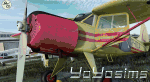
This is repaint of Yak-12A SP-KLA. The skin is dedicated for model A1R Design Bureau (payware addon) for Prepar3Dv4.
This plane was used in 1983 by pilot Leszek Piłat who escaped during period of "Iron curtain" from Poland (airfield Świdnik) to West Germany (Berlin - Tempelhof) with 3 passengers and one child. The set has outside textures and completly rebuilded inside textures (cockpit). It contains many new effects (like weathering, improved textures, parts in new alpha channels ect). The skin was created and tested in P3Dv5 (model for v4 works well here also). Enjoy!
| Filename: | Yak12A_SPKLA.zip |
| License: | Freeware, limited distribution |
| Added: | 16th May 2020, 17:48:56 |
| Downloads: | 67 |
| Author: | Rafal Stankiewicz / yoyosims |
| Size: | 71.76 MB |
| Category: Microsoft Flight Simulator (2020) - Aircraft Repaints, Textures and Modifications | |
| Supermarine Spitfire Mk.IX (H-35) Dutch Air Force |
|
Images related to this file:
File Description:
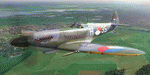
This folder contains a repaint for the Spitfire Mk.IX by FlyingIron, in the colors of Spitfire IX MJ580 H-35 of the Dutch Air Force, 1948-1950. This aircraft, built in 1943, flew with No.165 Sqn during the war. In 1948 it was sold to the Dutch Air Force and was flown to Twente airfield in October 1948, becoming H-35 (this paint). It was later painted silver and became 3W-5 with 322 squadron. In 1952 it made an emergency landing in Hilversum, was deemed beyond repair and scrapped.. Repaint by Jan Kees Blom Repaint by Jan Kees Blom.
| Filename: | Supermarine_Spitfire_MkIX_H35_Dutch_Air_Force.zip |
| License: | Freeware |
| Added: | 14th March 2021, 21:19:15 |
| Downloads: | 15 |
| Author: | Jan Kees Blom |
| Size: | 104.93 MB |
| Category: Flight Simulator X - Scenery | |
| RAF Harwell 1944 - Oxfordshire, England |
|
File Description:
RAF Harwell is a former Royal Air Force station in former Berkshire, near the village of Harwell, located 4.8 miles (7.7 km) south east of Wantage, Oxfordshire and 17 miles (27 km) north west of Reading.
The bulk of the Station lay within Chilton parish; about a third was in East Hendred; and the smallest portion was in Harwell. The first Commanding Officer, upon being asked what the name of the new airfield should be, responded that it should be named after the parish in which his house lay – and this happened to be Harwell.
| Filename: | RAF_Harwell_1944__Oxfordshire_England.zip |
| License: | Freeware |
| Added: | 26th April 2016, 14:33:34 |
| Downloads: | 128 |
| Author: | Terry Boissel |
| Size: | 642.7 KB |
| Category: Flight Simulator X - Scenery | |
| RAF Peplow - Shropshire, England |
|
File Description:
RAF Peplow (Child Ercall) X3PP is located 7 miles from Market Dayton, the Station started life as RAF Childs Ercall but this was changed to RAF Peplow in August 1943 to avoid confusion with a nearby stations called High Ercall.
The station follows the usual 3 runway pattern of the period, however, the technical site was unusual in that it was located in between 2 runways on the airfield side of the peri-track
There is plenty of information about the units that were stationed at the base available on the internet.
| Filename: | RAF_Peplow__Shropshire_England.zip |
| License: | Freeware |
| Added: | 6th January 2016, 15:19:11 |
| Downloads: | 223 |
| Author: | Terry Boissel |
| Size: | 1.15 MB |
| Category: Flight Simulator X - Scenery | |
| RAF Metheringham - Lincoln, Lincolnshire, England |
|
File Description:
RAF Metheringham was a Royal Air Force station situated between the villages of Metheringham and Martin and 12.1 mi (19.5 km) south east of the county town Lincoln, Lincolnshire, England. Third party addons will be required - see Readme.txt file for details.
Operated as a bomber airfield during World War II the station opened in October 1943 and was decommissioned in the spring of 1946.
Although now mostly returned to agricultural and commercial uses the site retains one original runway, the eastern perimeter track and some contemporary buildings together with a No. 106 Squadron RAF memorial garden and a visitor centre.
Souce: Wikipedia
| Filename: | RAF_Metheringham__Lincoln_Lincolnshire_England.zip |
| License: | Freeware |
| Added: | 12th November 2015, 16:12:55 |
| Downloads: | 306 |
| Author: | Terry Boissel |
| Size: | 95.79 KB |
© 2001-2026 AVSIM Online
All Rights Reserved
Privacy Policy |