
Where Flight Simulation Enthusiasts Gather from Around the World!
AVSIM Library - Search Results

| Category: Flight Simulator 2002 - Scenery | |
| Greek Airfields Enhancements |

|
File Description:
Version 3 of thirtysix Hellenic airfields and heliports, which were left only with a simple runway by MS, or were not there at all, are enhanced. Basic ASD buildings, Trees, Apron, signs, lights, runway and some custom objects added to enhance the sence of "scale". It includes dangerous airports Samos, Kerkyra, Ioannina and Skiros AFB. The package includes new Greek airfield Kalymnos and new airport of Sitia LGST which comes to join the list of Greece's dangerous airports. Previous releases (makaf1.zip , grsmaf.zip, grafse1.zip, graf2k2.zip , graf2k2u.zip) are not valid anymore. ASD Textures included.
| Filename: | Greek_Airfields_Enhancements.zip |
| License: | Freeware |
| Added: | 15th November 2002, 18:44:05 |
| Downloads: | 5,476 |
| Author: | Kyprianos Biris |
| Size: | 2.53 MB |
| Category: Prepar3D V1-4 - Scenery | |
| GVSF - São Filipe Airport |
|
File Description:
P3Dv4 - São Filipe Airport (Portuguese: Aeródromo de São Filipe, also: Aeródromo do Fogo) (IATA: SFL, ICAO: GVSF) is Cape Verde's fifth most-used airport, located in the island of Fogo.
It is located 2 km southeast of the town of São Filipe, near the Atlantic Ocean. It is used for domestic flights only.
The airport was completed in 1997,replacing a smaller airfield at the same location. Its runway measures 1,350 metres (4,430 ft) by 30 metres (98 ft) wide. The maximum single-wheel load is 20 tonnes
| Filename: | GVSF__So_Filipe_Airport.zip |
| License: | Freeware |
| Added: | 3rd May 2022, 00:56:33 |
| Downloads: | 124 |
| Author: | Eduardo Puelker |
| Size: | 4.84 MB |
| Category: X-Plane - Scenery | |
| WXPJ Susi Air Puncak Jaya Mining Airstrip v1.0.0 |
|
Images related to this file:
File Description:
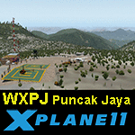
This is an X-Plane 11 scenery for Puncak Jaya Mining Airstrip (WXPJ) in the Puncak Jaya mountain region of Papua, Indonesia. This is a fictitious airfield, located in a high altitute mining location in Papua. At 4884 metres (16024 ft) above sea level, the Puncak Jaya peak, next to the mining location, is the highest mountain in Indonesia, on the island of New Guinea (which consists of the Indonesian West Papua region plus Papua New Guinea). This fictitious airfield may serve as a high altitute mining location challenge while flying the airstrips in Papua, as one of the destinations for "PT ASI Pujiastuti Aviation", operating as Susi Air, an Indonesia airlines established in late 2004 by Mrs. Susi Pudjiastuti. This scenery was tested and is operational (as of January 20, 2017) in "X-Plane 11 Public Beta #6 64 bit", Windows 10 Home. It was also tested and is partially operational (as of January 20, 2017) in "X-Plane 10.51 64 bit", Windows 10 Home. The issue with XP10 is the mesh again: there is no mine mesh, just a whole. The feel is very different from XP11, but it is still operational in XP10 to fly in and out.
| Filename: | WXPJ_Susi_Air_Puncak_Jaya_Mining_Airstrip_v100.zip |
| License: | Freeware |
| Added: | 21st January 2017, 18:42:35 |
| Downloads: | 58 |
| Author: | Rui Mesquita |
| Size: | 2.2 MB |
| Category: X-Plane - Scenery | |
| BR RJ SBME - Macae Airport v1.0.0 |
|
Images related to this file:
File Description:
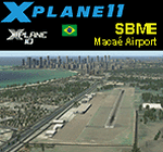
This is an X-Plane 11 and X-Plane 10 scenery package for Benedito Lacerda Airport (IATA: MEA, ICAO: SBME) is the airport serving Macaé, RJ, in Brazil. It includes corrected aprons, ramps, gates, taxiways, lighting system, city buildings, ortho-photoscenery for the airfield area, and (XP11 only) airport ground services (like push back). The airport was established in the 1960s as an airfield for general aviation and a Flying club. In the 1980s the runway was paved and an apron and a terminal with 941 m² were constructed, enabling Macaé Airport to fully support the operations related to the Campos basin (off shore oil platform in the costal area of the state of Rio de Janeiro). In fact, most of its movement (98%) is related to helicopter flights to/from offshore oil platforms of the Campos basin. It features a lot of apron positions for rotorcrafts. This scenery was tested and is operational (as of March 26, 2017) in "X-Plane 11 Public Beta #17 64 bit", Windows 10 Home. It was also tested and is also operational (as of March 26, 2017) in "X-Plane 10.51 64 bit", Windows 10 Home. Only the default X-Plane 11 libraries, by Laminar Research, are needed. No third party libraries are used.
| Filename: | BR_RJ_SBME__Macae_Airport_v100.zip |
| License: | Freeware |
| Added: | 29th March 2017, 03:50:00 |
| Downloads: | 80 |
| Author: | Rui Mesquita |
| Size: | 14.62 MB |
| Category: Flight Simulator X - Scenery | |
| RNAS Twatt (HMS Tern) |
|
File Description:
Opened on the 1 April 1941 RNAS (HMS Tern) was used throughout the second world war by various Sqns of the Royal Navy undergoing training.
The station had 4 concrete runways with various hangers and the usual building associated with a military base. It was also the first unit in the UK to experience a helicopter crash when a Sikorsky helicopter getting ready for take off; hit a parked Blenheim.
The UK and Iceland where involved in what was called the cod wars in the early 1970s, and NATO was concerned that it would have to remove its bases from Iceland should the dispute escalate between the 2 countries and there was talk of Twatt becoming a NATO base. However, this did not happen and the idea was dropped.
There was also talk of the unit becoming a base for helicopters supporting the oil industry, however, as a result of the drop in oil prices during the 80s that idea was also dropped.
Most of the airfield has been returned to farming now with only the unique Control Tower and a handful of other building remaining.
NB: For more detailed history of this unit go to:-
https://canmore.org.uk/site/81752/twatt-airfield
| Filename: | RNAS_Twatt_HMS_Tern.zip |
| License: | Freeware |
| Added: | 30th January 2017, 02:56:37 |
| Downloads: | 143 |
| Author: | Terry Boissel |
| Size: | 18.84 MB |
| Category: Flight Simulator 2004 - Scenery | |
| Green Lake CBG2 in British Columbia Canada |
|
Images related to this file:
File Description:
Green Lake is on the eastern side of the Coast Mountains of British Columbia, around 40 miles north of Cache Creek and 15 miles south of 100 Miles House (a previous posting). The airfield is beside the lake shore and serves the Flying U holiday ranch with a grass runway 2,575 feet long and aligned 18-36. There is no lighting. There is also mooring on the lake for boats and float planes. I have posted it as Green Lake CBG2, but I suggest that you just add it to your previously created "BC airfields", if you followed my previous suggestion. You then avoid the inevitable doubling up of common textures etc. Plus that way you will have just one FS9 library post to do and new airfields will not need yet another posting. Up to you. It just occurred to me that probably only a few of you have a copy of the Nav Canada Airfields handbook, so won't know the airfield altitudes, which is useful to have amid mountains. So, Pemberton is 670 feet Above Sea Level, Cache Creek 2,034 feet ASL, and Green Lake 3,550 feet ASL. The others to follow as posted. If you find a defect, email me.
| Filename: | Green_Lake_CBG2_in_British_Columbia_Canada.zip |
| License: | Freeware, limited distribution |
| Added: | 18th November 2020, 19:44:00 |
| Downloads: | 85 |
| Author: | Roger Wensley |
| Size: | 10.05 MB |
| Category: Flight Simulator 2004 - Scenery | |
| Mackenzie River close to Tulita CZFN in Northwest Territories Canada |
|
Images related to this file:
File Description:
I discovered, while testing another airfield near the Mackenzie River, that along the side of the Mackenzie adjacent to Tulita, and for a considerable distance, there was a cliff of water. I have no idea if my version of Ultimate Terrain has developed a fault or if this has been caused by the installation of a terrain mesh that now argues with UT for some unknown reason. Whatever, it was impossible to leave it as it was. I have included a screenshot of the cliff further upstream. To avoid the cliff of water I have flattened that area of the Mackenzie River and the adjacent river banks and both the town and the airfield to a height above sea level of 400 feet. This does not reflect the real life situation but is the lesser of two optical evils. I have included a screenshot of the flattened area. If you do not have a problem then you do not need this. If you too have a cliff of water then you might want to try this. It does not completely get rid of the problem, but it does get rid of it in the area visible when landing or taking off at Tulita.
| Filename: | Mackenzie_River_close_to_Tulita_CZFN_in_Northwest_.zip |
| License: | Freeware, limited distribution |
| Added: | 1st August 2021, 22:27:01 |
| Downloads: | 74 |
| Author: | Roger Wensley |
| Size: | 573.48 KB |
| Category: Flight Simulator 2004 - Scenery | |
| RAF Middleton St. George |
|
Images related to this file:
File Description:
Representative scenery of RAF Middleton St. George in County Durham.
The airfield began its life as Royal Air Force Station Goosepool, and in 1941 became RAF Middleton St. George. The aerodrome opened as a Bomber Command station in 1941. In 1943 it was allocated to No. 6 Group, Royal Canadian Air Force. A sub-station was located at RAF Croft, Yorkshire. Squadrons based here include: 76 Squadron, which flew Halifaxes, 78 Squadron, which flew Whitleys, 419 Squadron RCAF, which flew Wellingtons, Halifaxes, and Lancasters, 420 Squadron RCAF, which flew Wellingtons, and 428 Squadron RCAF, which flew Wellingtons, Halifaxes, and Lancasters.
After the war, the aerodrome served various squadrons and units including No. 13 Operational Training Unit (OTU), No. 2 Air Navigation School, No. 4 Flight Training School, 226 OCU and squadrons that used Meteors, Hunters, Javelins and Lightnings.
The RAF left the station in 1964, but the aerodrome was reopened in 1966 as a civil airport. The airfield was named Teesside International Airport in the 1960s, and was renamed Durham Tees Valley Airport in 2004.
This scenery has been made using various scenery libraries, mainly from MAIW. Full listing in the docs.
| Filename: | RAF_Middleton_St_George.zip |
| License: | Freeware, limited distribution |
| Added: | 22nd June 2014, 18:31:59 |
| Downloads: | 1,179 |
| Author: | Brian Clarke; Daryl Payne |
| Size: | 3.84 MB |
| Category: Flight Simulator 2004 - Scenery | |
| Memmingen Airbase (ETSM, South-Germany) including MilCom AI-Traffic |
|
File Description:
This airbase, located in the beautiful Allgaeu (Bavaria, South-Germany) about
55 NM in the west of Munich, was the homebase of the JaBoG34 riding the F104
1964 thru 1987 and then the Tornado PA200. After JaboG34 had been dissolved
in 2003, it was decided to use the airfield for commercial air traffic.
In memory of the JaBoG34 at the "Memminger Berg" and to keep the ATC people busy,
I created this airfield with combined military / commercial AI-Traffic.
The included AI-Package contains Lockheed F-104 GAF, Republik F-84F GAF,
Panavia-Tornado GAF, Airbus-A310 GAF, Lockheed-P3 Orion GNY, Boeing-727 with
UN paint, Boeing-737 Lauda, Bombardier CRJ-200 Lufthansa and aircraft.cfg for
MS: Beech-Baron 58, King-Air 350, and Learjet 45.
Several F104's and Tornados perform touch and goes in the local area, further an
UN-B727 leaves IFR to Decimomannu (LIED) and a GAF-A310 goes IFR to Cologne.
Some of the commercial airplanes perform touch and goes also, a CRJ-200 goes
IFR to Munich and a Lauda-737 goes IFR to Vienna per attached flightplan.
Lago's FSE is required in order to see most of the major buildings / objects.
Welcome to the party again.
| Filename: | Memmingen_Airbase_ETSM_SouthGermany_including_MilC.zip |
| License: | Freeware, limited distribution |
| Added: | 16th November 2005, 16:22:23 |
| Downloads: | 7,702 |
| Author: | Klaus Jone |
| Size: | 11.47 MB |
| Category: Flight Simulator 2004 - Scenery | |
| Koyukuk KYU in Alaska |
|
Images related to this file:
File Description:
Koyukuk is a small village on the northern bank of the Yukon River, around 5 miles east of where the river turns from north-south to east-west, east being upstream towards the distant Fairbanks. The mouth of the Koyukuk River that joins the Yukon is just to the east of the village. The population is now under 100 and living from fishing and the land. During the late 1800's the local population lived off the land and also by the spin off from gold mining in the same way as the nearby Nulato, but when in the early 1900's gold mining activities moved to Nome and Fairbanks local prosperity plunged. In fact, the village only became a permanently inhabited establishment in 1939, when a school was built. The airfield is close by and has a gravel runway aligned 6-24 and 4,000 feet long with PAPI on the approach to 6. There is also a shorter and parallel grass runway that is only used in the winter snows by light planes that are on skis and without wheels. Apart from the airfield itself, and it's buildings, this scenery modifies the local land class, adds village buildings while reducing the village size to reality, and creates a new airfield background. Koyukuk is served by Wright Air from Fairbanks in the east and this is included in the AI provided with the post of Nulato. A note here about my scenery making. This is post number 509 and there will not be many more to follow this as I am almost at the end of the photos I either took or found for scenery purposes. There is a limit to what can be located online and I have already been making use of the little there is; eg Unalakleet. So, if you are near an airport (preferably Canadian or Alaskan) and have a camera..... Let me know.
| Filename: | Koyukuk_KYU_in_Alaska.zip |
| License: | Freeware, limited distribution |
| Added: | 30th August 2019, 18:23:12 |
| Downloads: | 124 |
| Author: | Roger Wensley |
| Size: | 3.26 MB |
© 2001-2026 AVSIM Online
All Rights Reserved
Privacy Policy |