
Where Flight Simulation Enthusiasts Gather from Around the World!
AVSIM Library - Search Results

| Category: Prepar3D V1-4 - Scenery | |
| Skelleftea ESNS Sweden |

|
Images related to this file:
File Description:
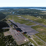
Skellefteå is a small Swedish airport located almost at the coast of Baltic Sea. This scenery provides the most accurate rendition of Skellefteå to date, with the expanded apron, an additional parking spot, and turn pad for runway 10. Six lakes, including Falmarksträsket and Bodaträsket, and most nearby roads, forests and villages were added to make the scenery VFR-friendly. The icing on the cake are authentic models of all buildings, created by MBL-Dezign. Seasonal photo background and night lighting are also included. Compatible with Prepar3D v4 and FSX. Made by Dmitriy Kozyrev.
| Filename: | Skelleftea_ESNS_Sweden.zip |
| License: | Freeware |
| Added: | 29th June 2018, 20:01:59 |
| Downloads: | 2,323 |
| Author: | Dmitriy Kozyrev |
| Size: | 44.29 MB |
| Category: Flight Simulator X - Aircraft Repaints, Textures and Modifications | |
| Bering Air Beechcraft B1900D |
|
Images related to this file:
File Description:
Bering Air Serves 32 Villages in Western Alaska from Hubs in Nome, Kotzebue and Unalakleet, and has been around for 30 years. This is an attempt to create their real world B1900D livery, registration number: N15GA. You must own a copy of PMDG Beechcraft 1900D to use these textures. Although I use FSX, these textures are native to FS9 and can be used with it as well. You will have to modify the configuration text entry to work with FS9, just follow the format used with your other FS9 PMDG B1900D aircraft. As for those using FSX, just copy the text as is, and follow the rest of the instructions.
| Filename: | Bering_Air_Beechcraft_B1900D.zip |
| License: | Freeware |
| Added: | 21st May 2011, 23:34:13 |
| Downloads: | 451 |
| Author: | Johnny Rosario |
| Size: | 9.03 MB |
| Category: Flight Simulator X - AFCAD Files | |
| ZGSZ - Shenzhen Bao'an Intl Airport - Shenzhen, China |
|
Images related to this file:
File Description:
ZGSZ - Bao´an Intl Airport - Shenzhen, China
Shenzhen Bao'an International Airport (formerly named Shenzhen Huangtian Airport) is located near Huangtian and Fuyong villages in Bao'an District, Shenzhen, Guangdong, China. It is 32 km northwest of the city center. It is the hub for Shenzhen Airlines, Shenzhen Donghai Airlines, SF Airlines, Jade Cargo International and a focus city for China Southern Airlines and Hainan Airlines. The airport also serves as an Asian-Pacific cargo hub for UPS Airlines.
Using ADEx 1.55, SBuilderX, aeronautical maps and Google Earth (2014) all these changes have been built into the default FSX airport to better reflect today´s situation.
| Filename: | ZGSZ__Shenzhen_Baoan_Intl_Airport__Shenzhen_China.zip |
| License: | Freeware |
| Added: | 30th January 2015, 16:52:24 |
| Downloads: | 4,390 |
| Author: | Menno C. Robert |
| Size: | 2.95 MB |
| Category: Flight Simulator X - Scenery | |
| LOXA Aigen im Ennstal |
|
Images related to this file:
File Description:
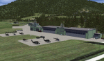
The military airport Aigen im Ennstal is a base of Austrian Airforce. It is primarily a base of Military helicopters.
Also, however, this airstrip is also used by the GRIMMING flight group.
I tried to reproduce the character of LOXA as well as possible.
The surroundings are adapted by landclasses. Aigen, surrounding villages and important roads are built-in.
The airport has a photo background in four variants, each adapted to the four seasons spring / summer, autumn and winter.
The buildings in this scenery are quite similar to the originals. I used the beautifull objekts of Kalle, who already designed this airport for XPlane in a very nice way.
| Filename: | LOXA_Aigen_im_Ennstal.zip |
| License: | Freeware |
| Added: | 17th December 2016, 07:52:44 |
| Downloads: | 1,492 |
| Author: | Wolfgang Allers |
| Size: | 236.7 MB |
| Category: Flight Simulator 2004 - Scenery | |
| Bethel: Yukon Area |
|
Images related to this file:
File Description:
This presumes you have already installed Bethel PABE, Bethel Local Airfields, and Bethel St Mary's. In the Yukon River area of Alaska to the north of Bethel and to the south around the equally wide (but shorter) Kuskowim River there are small villages, served by flights from both Bethel PABE and St Mary's PASM. These villages are dependent upon fishing for survival, and in this flat and very wet terrain are equally dependent upon the gravel runways that link them to the outside world. There are no surfaced roads, and the rivers and their tributaries wind into the distance and are impractical delivery routes except from nearby places. In an area 300 miles by 200 miles most places cannot be described as "nearby". This post is of the small villages, including those previously posted; I had missed on picking up some terrain conflicts between nighttime grass and town textures. They are corrected here and included along with new airfields. Bethel and St Mary's are also reposted to include the further enlargement of parking for the increased number of small AI aircraft. These smaller airfields vary in quality; some have runway signage but most do not, and while some have two or even three hangars/garages/terminal buildings on the apron there are others who have none at all. The 39 small airfields included here are as listed:
Akiak AKI, Akiakchak Z13, Alakanuk AUK, Anvik PANV, Atmautluak 4A2, Cape Romanzof PACZ, Chefornak PACK, Chevak VAK, Eek EEK, Emmonak PAEM, Goodnews GNU, Grayling KGX, Holy Cross HCA, Hooper Bay PAHP, Kako 9AK2, Kalskag KLG, Kasigluk Z09, Kipnuk PAKI, Kongiganak PADY, Kotlik KOT, Kwethluk KWT, Kwigillingok A85, Marshall MLL, Mountain Village MOU, Napakiak WNA, Napaskiak PKA, Newtok PAEW, Nightmute IGT, Nunapichuk 16A, Pilot Station 0AK, Quinhagak PAQH, Russian Mission RSH, Scammon Bay SCM, Shageluk SHX, Sheldon Point SXP, Toksook Bay OOK, Tuluksak TLT, Tuntutuliak A61, Tununak 4KA.
I am currently going through the airfields again to check if further modifications are required, and I am also adding a few new ones. As I am going to be updating my computer I am posting now, complete or not, and I will post an update later of further additions.
| Filename: | Bethel_Yukon_Area.zip |
| License: | Freeware, limited distribution |
| Added: | 3rd May 2019, 17:20:53 |
| Downloads: | 170 |
| Author: | Roger Wensley |
| Size: | 6.3 MB |
| Category: Flight Simulator X - Scenery | |
| IGT - Nightmute Airport - Alaska, USA |
|
Images related to this file:
File Description:
The airport islocated southeast of the central business district of the vellage of Nightmute.Nightmute is located on Nelson Island near Toksook Bay. The two villages connect by snowmachine trail in winter.
Runway 2/20 was changed to 3/21. Changed the length of Runway 3/21 from 50 feet wide and a legth of 1,600 feet to 75 feet wide and 3,200 feet long.Added Runway 11/29 along with custom models.Changes are based on construction plans dated 2005.
Created with Airport Design Editor by ScruffyDuck Software using current FAA documentation and Google Earth's measurements, this package offers a replacement for FSX's stock airport. All these enhancements are as close to the real airport as I can get with stock library objects and custom buildings.
| Filename: | IGT__Nightmute_Airport__Alaska_USA.zip |
| License: | Freeware |
| Added: | 3rd February 2015, 09:12:14 |
| Downloads: | 671 |
| Author: | Wayne Roberts |
| Size: | 197.17 KB |
| Category: Flight Simulator X - Scenery | |
| LGLS - Lousoi Airfield **Fictional** |
|
Images related to this file:
File Description:
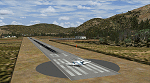
An imaginary airfield in north central Peloponnese Greece named after the elevated mountain plain where it would be situated. LGLS Lousoi airfield has a 1,000m runway at elevation of 3,186ft surrounded by mountains.
The aiport is equiped with NDB, ILS DME, PAPIs and night lighting for instrument approaches; approach chart included.
As bonus two imaginary helipads LGKK Kleitoria and LGPP Planitero are added in the nearby two villages.
All are infrastructure I wish they existed in the area since I drive there often for vacations in Planitero and always wondered how it would be if I could fly there. Planitero sits at the south footings of Chelmos mountain, the highest peak in the area. No AI traffic plans included.
| Filename: | LGLS__Lousoi_Airfield_Fictional.zip |
| License: | Freeware, limited distribution |
| Added: | 15th April 2015, 01:07:43 |
| Downloads: | 138 |
| Author: | Kyprianos Biris |
| Size: | 1.87 MB |
| Category: Flight Simulator 2004 - Scenery | |
| Tokelau Islands - Complete Scenery |
|
Images related to this file:
File Description: NOTICE: There is one object library that is necessary but I forgot to mention in the pdf documentation! It is the file 'ez_housez_and_buildings.zip' here in the library by Ron Jeffers.
This project is a complete scenery rendition of the archipelago of Tokelau for FS2004.
The scenery includes all islands, with detailed coastlines, Landclass with villages represented, and Waterclass with the shallow reef banks also recreated.
Included are also 4 separate AFCAD files which generate 4 fictional airfields, one on each atoll.
Many objects were also added to give the scenery a less desolate and more alive look.
This is my first complete scenery project, my previous scenery uploads consisted only of AFCAD files or LC files.
Enjoy exploring these gems in the South Pacific!
| Filename: | Tokelau_Islands__Complete_Scenery.zip |
| License: | Freeware, limited distribution |
| Added: | 8th March 2018, 00:37:09 |
| Downloads: | 536 |
| Author: | Leonardo Santos |
| Size: | 11.91 MB |
| Category: Flight Simulator 2004 - Scenery | |
| Bethel: St Mary's area airfields in southwest Alaska close to the Yukon River |
|
Images related to this file:
File Description:
This presumes you have already installed Bethel PABE and Bethel Local Airfields. In the Yukon River area of Alaska to the north of Bethel there are small villages, served by flights from both Bethel and the nearer St Mary's PASM. St Mary's has a gravel runway like the other villages, but has a larger population and airport services including maintenance and fuel. This, plus the saving of an average one hundred miles of flying by a Cessna 205 when compared with flights from Bethel, means it acts as a distribution centre fed from Bethel by larger aircraft. Go to "http://vfrmap.com/" for free vfr maps of the area (see the attached). The ten village airfields included here are all to the north and west of St Mary's: Hooper Bay PAHP, Chevak VAK, Cape Romanzof PACZ (closed air force field servicing a radar station), Scammon Bay SCM, Sheldon Point SXP, Alakanuk AUK, Emmonak PAEM, Kotlik 2A9, Mountain Village MOU, and of course St Mary's PASM itself. With these airfields not everything is as it appears to be. For instance, Hooper Bay is not a new and modernised airfield, despite the asphalt runway and apron; the current version has dispensed with the aging asphalt and gone back to gravel. I have tended to go for the 2005 or so versions, which sometimes means a small runway amid or close to the housing; Kotlik was an early renewal for reasons of safety as much as anything else and has had (since 2003?) a new and longer runway located outside of the town. The second batch of airfields will be to the east of St Mary's.
| Filename: | Bethel_St_Marys_area_airfields_in_southwest_Alaska.zip |
| License: | Freeware, limited distribution |
| Added: | 29th April 2019, 17:07:24 |
| Downloads: | 226 |
| Author: | Roger Wensley |
| Size: | 11.53 MB |
| Category: Flight Simulator 2004 - Scenery | |
| Israel, the Holy Land - 1North (ver. 01) |
|
File Description:
FS2002/FS2004 highly detailed landclass for Northern Israel, covering the Land of Upper and Lower Galilee, Lake of Galilee and the coastal area of North-Western Israel. Within this area there are many places with historical and Geographical significance for those who are interested in that part of the world. "Israel, the Holy Land 1" is the first released part of an ongoing effort to cover all of Israel with new, detailed landclass. The scenery is made in the highest LOD (level of detail) and shows realisticl coast lines, ports, highways, important secondary roads and rail roads, cities, towns and villages of 2,000 residents and above, accurate vegetation, sand dunes, quarries, and other landuses needed for VFR. The scenery is enhanced with night lighting to enable easy VFR navigation by night.
| Filename: | Israel_the_Holy_Land__1North_ver_01.zip |
| License: | Freeware |
| Added: | 24th October 2003, 16:36:42 |
| Downloads: | 5,804 |
| Author: | Seev Kahn |
| Size: | 2.37 MB |


© 2001-2026 AVSIM Online
All Rights Reserved
Privacy Policy |