
Where Flight Simulation Enthusiasts Gather from Around the World!
AVSIM Library - Search Results

| Category: Flight Simulator 2004 - Scenery | |
| New Terrain Mesh of the Province of Quebec in LOD09 (3/4) |

|
File Description:
The files in this package contain terrain mesh files of the province of Quebec (N45 to N53) to be used with my Quebec enhanced sceneries for FS2004 (Scenes_du_Quebec_2k4.zip). The public data sources are the Shuttle Radar Topography Mission (SRTM-3, 90m) and the Canadian Digital Elevation Data (CDED - 0.75s/arc - 23m). (QC09_2k4a.zip to QC09_2k4d.zip - 4 parts)
***********************
Les fichiers de ces archives contiennent les donnees d'elevation de terrain (mesh files - lod09), pour FS2004, du territoire de la province de Quebec sous le 53ieme degre de latitude nord. Ils ont ete crees pour etre utilises avec mes nouvelles scenes du Quebec contenues dans Scenes_du_Quebec_2k4.zip. Les donnees sources sont du domaine public et proviennent de la Shuttle Radar Topography Mission (SRTM-3, 90m) et des donnees numerique d'elevation du Canada (DNEC - 0.75s/arc -23 m). (QC09_2k4a.zip to QC09_2k4d.zip - 4 parties)
| Filename: | New_Terrain_Mesh_of_the_Province_of_Quebec_in_LOD0.zip |
| License: | Freeware, limited distribution |
| Added: | 27th January 2010, 18:15:12 |
| Downloads: | 7,493 |
| Author: | Gilles Gauthier |
| Size: | 29.35 MB |
| Category: Flight Simulator 2004 - Scenery | |
| New Terrain Mesh of the Province of Quebec in LOD09 (4/4) |
|
File Description:
The files in this package contain terrain mesh files of the province of Quebec (N45 to N53) to be used with my Quebec enhanced sceneries for FS2004 (Scenes_du_Quebec_2k4.zip). The public data sources are the Shuttle Radar Topography Mission (SRTM-3, 90m) and the Canadian Digital Elevation Data (CDED - 0.75s/arc - 23m). (QC09_2k4a.zip to QC09_2k4d.zip - 4 parts)
***********************
Les fichiers de ces archives contiennent les donnees d'elevation de terrain (mesh files - lod09), pour FS2004, du territoire de la province de Quebec sous le 53ieme degre de latitude nord. Ils ont ete crees pour etre utilises avec mes nouvelles scenes du Quebec contenues dans Scenes_du_Quebec_2k4.zip. Les donnees sources sont du domaine public et proviennent de la Shuttle Radar Topography Mission (SRTM-3, 90m) et des donnees numerique d'elevation du Canada (DNEC - 0.75s/arc -23 m). (QC09_2k4a.zip to QC09_2k4d.zip - 4 parties)
| Filename: | New_Terrain_Mesh_of_the_Province_of_Quebec_in_LOD0.zip |
| License: | Freeware, limited distribution |
| Added: | 27th January 2010, 18:17:08 |
| Downloads: | 7,852 |
| Author: | Gilles Gauthier |
| Size: | 20.94 MB |
| Category: Fly! II - Aircraft | |
| De Havilland DHC 3 Otter Amphibian |
|
File Description:
IBM PC version
The De Havilland Canada DHC3 Otter was built in the mid 1950's as a workhorse for developing outback Canada. With double slotted full span flaps (drooping ailerons) and 2000lbs payload, its STOL capability, along with also having a float version with retracts, made it an ideal "Bushplane" with unparalelled performance from any contempory aircraft.
This model is fully amphibious and was built using Truespace 3.2 and Chris Wallace's 3ds to S3d converter for Fly! II.
The model requires that you have the Tri default aircraft installed.
A few non-standard features have been included to improve the ease of operation.
1. nose wheel steering (the original uses differential braking and castoring nose gears)
2. an electric pump for hydraulics (optional on the original )
3. a simple GPS that can be slaved to the auto pilot. (unheard of during the production life of the original but very likely to be found on any survivng present day aircraft. )
Enjoy.
| Filename: | De_Havilland_DHC_3__Otter__Amphibian.zip |
| License: | Freeware, limited distribution |
| Added: | 29th June 2006, 00:15:44 |
| Downloads: | 444 |
| Author: | Alejandro Amigorena Laurence Claudet Roger Mazengarb F2FD |
| Size: | 2.83 MB |
| Category: Flight Simulator 2004 - Scenery Design | |
| TDFCalc2004 (Version 3) |
|
File Description:
This package is for FS2004 and FS2002 terrain designers. TDFCalc2004 is made for use with FSUIPC and FS2004. This is a version that includes true heading readings, and LOD8 Zone coordinates for VTP2 lines and polys. It is an FSUIPC registered freeware program that requires version 3.? of FSUIPC.dll installed to the FS2004 Module folder. FSUIPC is avaliable on the internet, and this program requires an application registration entered within FSUIPC. Usage with FS2002 or CFS2 requires no registration with the older versions of FSUIPC. LandCalc and TDFCalc2 are small programs which require the input of Latitude and Longitude, in 'DD:MM.decimal' format. Landcalc returns the names of the "CUSTOM" textures required by photoreal ( CUSTOM ) BGLs, and LandClass BGLs ( using values #253 or #252 ). TDFCalc2 returns valuable information concerning the X, Y coordinates needed for the creation of LWM and VTP polygons/lines. TMFViewerCalc requires input as Decimal Degrees.
| Filename: | TDFCalc2004_Version_3.zip |
| License: | Freeware |
| Added: | 5th October 2003, 18:48:15 |
| Downloads: | 1,324 |
| Author: | Richard Ludowise |
| Size: | 926.55 KB |
| Category: Fly! II - Aircraft | |
| De Havilland Canada DHC2 Beaver (on floats with retracts) |
|
File Description:
IBM PC VERSION ONLY. This file contains DLL's that are not Mac. compatible.
A total of over 1500 aircraft were built. With double slotted full span flaps (drooping ailerons) and 1000lbs payload, its STOL capability, along with having a float version with retracts, made it an ideal "Bushplane" with unparalelled performance from any contempory aircraft. Many Beavers are still in use today.
The model was built using Truespace 4.3 and Chris Wallace's 3ds to S3d converter. Photorealistic interior views are used with auto switching day-time/night-time main panel.
The model requires that you have the Tri default aircraft installed.
A few non-standard features have been included to improve the ease of operation.
1. nose wheel steering (the original uses differential braking and castoring nose gears)
2. an electric pump for hydraulics (optional on the original )
3. a simple GPS that can be slaved to the auto pilot. (unheard of during the production life of the original but very likely to be found on any survivng present day aircraft.
4. a transponder has been added to enable IFR flights
| Filename: | De_Havilland_Canada_DHC2_Beaver__on_floats_with_re.zip |
| License: | Freeware, limited distribution |
| Added: | 31st August 2008, 07:45:53 |
| Downloads: | 314 |
| Author: | Paul Simpson, Laurent Claudet, Randall Rocke, Roger Mazengarb |
| Size: | 4.85 MB |
| Category: Flight Simulator 2004 - Scenery | |
| Gang Ranch CAY2 in British Columbia Canada |
|
Images related to this file:
File Description:
Gang Ranch is on the eastern side of the Coast Mountains of British Columbia, around 50 miles west of Green Lake and 5 miles west of the Fraser River that runs north-south at that latitude (51 degrees 30 minutes north, in round figures). The airfield is among some farm fields and difficult to spot (this will depend on your personal textures and settings) and the ranch buildings are scattered and a mile or two away, the nearest being the owner's house. The runway is gravel, only 1,800 feet long and aligned 08-26 at 2,150 feet above sea level. There is no lighting. I have posted it as Gang Ranch CAY2, but I suggest that you just add it to your previously created "BC airfields" (if you did that) and avoid the inevitable doubling up of common textures etc. Plus that way you will have just one FS9 library post to do and new airfields will not need yet another posting. Up to you. If you find a defect, email me.
| Filename: | Gang_Ranch_CAY2_in_British_Columbia_Canada.zip |
| License: | Freeware, limited distribution |
| Added: | 19th November 2020, 19:44:55 |
| Downloads: | 98 |
| Author: | Roger Wensley |
| Size: | 8.98 MB |
| Category: Flight Simulator 2004 - Gauges | |
| FS2004 Simulated Aircraft Bubble Sextant |
|
File Description:
As travel by air developed and matured, navigation over long distances also developed and improved. In the early days, however, air navigation essentially used ship navigation techniques adapted for aircraft. Without "landmarks", the navigators used Ded Reckoning (DR) and the stars. Celestial or Astronomical Navigation provides a means of obtaining Lines of Position (LOPs) from the stars. Crossing LOPs will fix a position. It requires a chart, and a planned course on that chart, with waypoints specified by Latitude and Longitude, an assumed time of arrival at each waypoint, and stars (including the Sun, Moon, or planets) in view. In the 1940s, extensive tables of star positions were made available to air navigators to be used with sextants to obtain these LOPs. In the tables, all times involved are GMT. This data is available from the Internet in "ready to use" form. This gauge simulates the sextant, and the process by which one obtains a LOP, or crossing LOPs to obtain a position, or fix. Can be used with any FS2004 aircraft. Includes comprehensive browser-based manual and references.
| Filename: | FS2004_Simulated_Aircraft_Bubble_Sextant.zip |
| License: | Freeware |
| Added: | 6th December 2004, 19:21:14 |
| Downloads: | 4,973 |
| Author: | Dave Bitzer, Mark Beaumont |
| Size: | 989.73 KB |
| Category: Flight Simulator 2004 - Scenery | |
| Iqaluit CYFB 2010 |
|
Images related to this file:
File Description:
Founded in 1942 as an American airbase, Iqaluit is now the capital city of the northern Canadian province of Nunavut. It is the smallest Canadian capital in terms of population and the only capital that is not connected to other settlements by a highway. The airport is of critical importance to the community, especially when ice makes boat travel impossible. At 62 degrees latitude (approx. the same as Yellowknife), Iqualuit offers some of the most severe weather you are likely to encounter at any airport, and has been used for cold weather testing of new airliners.
This version of Iqaluit is a complete rebuild of the default version. Almost all the buildings have been custom modeled based on photos. The design of the terminal building at Iqaluit is one of the coolest I've seen, and was the main inspiration for making this scenery. Due to its complexity many details had to be omitted, but hopefully I was able to at least capture some of its "Yellow Submarine" uniqueness. Ramp lights, fences, ground objects, arrestor cables (non-functional) and all the rest of the usual junk is included. Also Instrument Approach Plates.
| Filename: | Iqaluit_CYFB_2010.zip |
| License: | Freeware |
| Added: | 26th December 2010, 15:38:20 |
| Downloads: | 2,684 |
| Author: | Sidney Schwartz |
| Size: | 4.18 MB |
| Category: Flight Simulator X - Utilities | |
| AI Aircraft SID and STAR Controller - Version 1.4B <b>for FSX, FSX Steam and P3D</b> |
|
Images related to this file:
File Description:
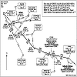
The AIController utility automatically vectors FSX, FSX-Steam or Prepar3D Artificial Intelligence (AI) aircraft through predefined Standard Instrument Departures (SIDs), jet routes, Standard Instrument Arrivals (STARs) (or alternatively generic traffic patterns), and/or final approaches. AIController automatically selects the most appropriate SID, jet route or STAR for each AI aircraft. AIController also lands arriving AI using published, custom or automatic final approach procedures, then provides taxi service to parking. The user can customize the procedures to fine tune AI arrival and departure patterns at each airport, such as specifying landing runways on-the-fly.
AIController optionally enforces spacing minimums between arriving AI aircraft by commanding speed changes and/or commanding the AI to hold at waypoints, thus reducing go-arounds. AIController can also enforce spacing minimums between the AI aircraft and the user's aircraft.
A stand-alone, windows based AI traffic monitoring program (AIMonitor.exe) is also included to provide the user with a graphical front-end. A converter (SIDSTARConverter) is included to automatically convert SID and STAR files from standard, aircraft format to the format used by AIController.
AIController requires an installed FSX or P3D SimConnect and can be run on a networked computer. The latest, registered version of FSUIPC ver. 4.9x (or later version) is also required.
| Filename: | AI_Aircraft_SID_and_STAR_Controller__Version_14B_b.zip |
| License: | Freeware |
| Added: | 18th July 2015, 00:11:26 |
| Downloads: | 14,165 |
| Author: | Roland Foster |
| Size: | 16.23 MB |
| Category: Flight Simulator 2004 - Utilities | |
| Destination Finder for FS9 v1.1 |
|
File Description:
In this program, you enter the ICAO code of your start airport, the distance you wish to fly, and the heading on which you wish to fly. The program will search through all the stock airports in FS9, and will compile a list of airports nearest to your desired destination. For extra flexibility, you can also leave the heading and/or the distance unspecified. Alternatively, the program can now read your aircraft’s position in all versions of FS, and use that as the starting point of the search. You can optionally specify a maximum and/or minimum length for the runway, whether the runway must have an ILS, a maximum elevation for the destination airport, the runway surface (hard or soft or water) and whether the airport should be civil or military or either. The program can be useful for planning your own flight or for drawing up AI flightplans. It is a standalone program, and uses FS9 airport and runway data, but, with that limitation in mind, it can equally be used with other versions of FS. Version 1.1 has a much improved formula for calculating longitude and latitude over longer distances, and is now very accurate over all distances. Version 1.1 also incorporates a number of new features suggested by user feedback. The upgrade is recommended for all users. Needs the .NET Framework 2.0.
| Filename: | Destination_Finder_for_FS9_v11.zip |
| License: | Freeware |
| Added: | 24th January 2008, 00:17:07 |
| Downloads: | 4,877 |
| Author: | Martin Gleeson |
| Size: | 1.69 MB |
© 2001-2026 AVSIM Online
All Rights Reserved
Privacy Policy |