
Where Flight Simulation Enthusiasts Gather from Around the World!
AVSIM Library - Search Results

| Category: Flight Simulator 2004 - Gauges | |
| Simulated Aircraft Bubble Sextant Chart (addon) |

|
File Description:
This is an add-on to the "dc3_bbsx.zip" Simulated Aircraft Bubble Sextant Gauge. While the simulated sextant determines the elevation to the star, it requires drawing lines of position on a chart to ascertain the latitude and longitude of the fix. The Global Navigation Charts (GNC) at scale 5,000,000:1 are suitable but not generally available for this purpose. This gauge simulates small sections of the proper chart, and automatically places the LOP from the sextant on the chart in the proper orientation. It includes installation and operating instructions, and an example flight description. Install the "dc3_bbsx.zip" first, if it hasn't been installed already.
| Filename: | Simulated_Aircraft_Bubble_Sextant_Chart_addon.zip |
| License: | Freeware, limited distribution |
| Added: | 17th March 2008, 04:15:43 |
| Downloads: | 1,183 |
| Author: | Dave Bitzer, Mark Beaumont |
| Size: | 907.27 KB |
| Category: Flight Simulator X - Utilities | |
| Gate A Nator Pre Flight Planning tool 2.1.0.42 |
|
Images related to this file:
File Description:
Gate A Nator is a freeware pre-flight tool and flight plan converter for FSX and Prepar3D that allows to customize a flight plan before starting a flight simulation session. Can set departing Gate position and can load flight plans from FSX/FS2004, Prepar3D, LEVELD, PMDG, Quality Wings and Flight Sim Commander, or from an ICAO route, and using Airac cycles (FSBuild2 format) to read navaids from. Installation package installs Airac Cycle 1904, that can be after updated from Navigraph. Gate/parking database is auto created and updated from FSX or Prepar3D scenery base.
It supports file save and export to FS2004, FSX, Prepar3D, LEVELD, PMDG, Quality Wings, Flight Sim Commander, XPlane 11 and Aerosoft Airbus/X extended.
Complete instructions guide is included in the help file.
| Filename: | Gate_A_Nator_Pre_Flight_Planning_tool_21042.zip |
| License: | Freeware, limited distribution |
| Added: | 22nd May 2019, 02:38:06 |
| Downloads: | 407 |
| Author: | Alessandro Antonini |
| Size: | 22.08 MB |
| Category: Flight Simulator 2004 - Utilities | |
| FSPause 1.2 |
|
File Description:
FSPause is a small utility to set pause in FS on conditions like latitude,longitude,altitude,speed or distance to a waypoint.
This new version offer logging and screenshots functions.
You can log main data on a csv text file.
You can import a Flight Simulator plan and merge it with the log file to print a flight plan report.
You can take automatic screenshots of FS screens and automaticaly change the angle of view periodicaly, disable rotation for some types of view, rename screenshots files with a filename including airports or waypoint name
Can be used on another computer with widefs.
You will need dotnet framework 1.1 and FSUIPC 3.x.
| Filename: | FSPause_12.zip |
| License: | Freeware |
| Added: | 27th July 2005, 23:24:31 |
| Downloads: | 2,085 |
| Author: | Patrick FABRE |
| Size: | 3.61 MB |
| Category: Prepar3D V1-4 - Scenery | |
| Marino Lighthouse South Australia |
|
File Description:
Marino Lighthouse
This lighthouse is a well known VFR reference and reporting point just outside the Adelaide TMA.
It installs quite happily in FSX, P3D v3.4 and P3Dv4 in the usual fashion.
It was crafted in Sketchup8, it was converted to a .bgl in Model Converter X _ http://www.scenerydesign.org/modelconverterx/ - (A HUGE shoutout to Arno Gerretsen). The ground textures and excludes were done in Luis Sa's SBuilderX - http://www.ptsim.com/index.php?option=com_content&view=article&id=52&Itemid=56 .
In the Marino Lighthouse Extras sub-directory I "show my work". Please mess about with it should you feel so inclined.
The usual caveats concerning the use of these files in pursuit of profit or monetary gain apply. Contravention thereof will earn you a scathing reprimand.
Quig
18/04/17
| Filename: | Marino_Lighthouse_South_Australia.zip |
| License: | Freeware |
| Added: | 25th June 2017, 07:25:14 |
| Downloads: | 133 |
| Author: | Richard Quigley |
| Size: | 3.66 MB |
| Category: Flight Simulator X - Aircraft Repaints, Textures and Modifications | |
| FSX Project Opensky HiFly Airbus A340-300 Liveries |
|
File Description:
Merry Christmas! This is my first Project Opensky Airbus livery! Major changes have been made since I uploaded my latest livery. 1. Mipmaps have been removed, 2. I added much more accuracy and detail than I used to before, and 3. I now use Model Converter X to check if my livery is alligned.
Aside from these changes, I made this livery requested by someone. It was requested all the way back on October, but I was just so busy.
NOTE: In order to use this livery, you must have the Airbus A340 Pack from Rikoooo. Download it here: https://www.rikoooo.com/downloads/viewdownload/6/688
The planes featured from this addon is:
9H-TQZ (Airbus A340-313) (Sorry if I didn't put the Persian Leopard decal)
9H-SUN (Airbus A340-312)
| Filename: | FSX_Project_Opensky_HiFly_Airbus_A340300_Liveries.zip |
| License: | Freeware |
| Added: | 26th December 2023, 00:15:44 |
| Downloads: | 113 |
| Author: | Rye Kristian Bunao |
| Size: | 5.79 MB |
| Category: Flight Simulator X - Utilities | |
| Flight Log Client (v1.9) |
|
Images related to this file:
File Description:

A Windows client software which acts as your black-box, tracking in real time your flight data like latitude, longitude, altitude, ground speed, true heading, radio frequencies like COM's, NAV's, Transponder and send them to our servers so you can save an history of your flghts and see it in our Log System Web Service. This software is the main key of our Log System, you'll be able to connect to our Log System to query the database and see your flight progress on every date. Flight Log Client is a FREEWARE software. A FREE account will be created at software first launch. Start logging your flights from now and keep an history of you Pilot life. Updated version, v1.9. Requires Peter Dawson's FSUIPC.
| Filename: | Flight_Log_Client_v19.zip |
| License: | Freeware |
| Added: | 24th April 2013, 23:05:52 |
| Downloads: | 325 |
| Author: | Mario Dantas |
| Size: | 4.93 MB |
| Category: Flight Simulator 2004 - Utilities | |
| TDFCalc2004 |
|
File Description:
This package is for FS2004 and FS2002 terrain designers. TDFCalc2004 is made for use with FSUIPC and FS2004. This is a version that includes true heading readings. It is an FSUIPC registered freeware program that requires version 3.? of FSUIPC.dll installed to the FS2004 Module folder. FSUIPC is a vailable on the internet, and this program requires an application registration entered within FSUIPC. Usage with FS2002 or CFS2 requires no registration with the older versions of FSUIPC. LandCalc and TDFCalc2 are small programs which require the input of Latitude and Longitude, in 'DD:MM.decimal' format. Landcalc returns the names of the "CUSTOM" textures required by photoreal ( CUSTOM ) BGLs, and LandClass BGLs ( using values #253 or #252 ). TDFCalc2 returns valuable information concerning the X, Y coordinates needed for the creation of LWM and VTP polygons/lines. TMFViewerCalc requires input as Decimal Degrees.
| Filename: | TDFCalc2004.zip |
| License: | Freeware |
| Added: | 6th September 2003, 21:12:04 |
| Downloads: | 1,728 |
| Author: | Richard Ludowise |
| Size: | 926.3 KB |
| Category: Flight Simulator X - Panels | |
| Alphasim F-111 Panel Package Version 2.0 |
|
Images related to this file:
File Description:
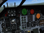
This upgrade to the Alphasim F-111 adds a Weapons System Operator Panel with default and old avionics packages, Working TERRAIN FOLLOWING RADAR scope
shows accurate ground mapping ahead of aircraft in 5, 10 or 15 mile ranges, THREAT WARNING DISPLAY shows airborne AI aircraft in 20 or 40 mile ranges, Ground Attack RADAR displays airports and AI aircraft on default panel and airports as ground targets in ranges of 5,10,30,80 and 200 miles on old avionics panel, Shockwave Lights ready, Updated afterburner effects, INS (old avionics panel) displays working digital readout of latitude, longitude, and altitude, TFR and TWR gauges automatically change brightness between day and night to match lighting conditions.New Autopilot and Lighting control panels. Features custom gauges created by Dietmar Loleit for this project. You must have the Alphasim F-111 aircraft package for this panel
| Filename: | Alphasim_F111_Panel_Package_Version_20.zip |
| License: | Freeware |
| Added: | 7th November 2009, 12:11:41 |
| Downloads: | 917 |
| Author: | Steve Hess |
| Size: | 15.88 MB |
| Category: Flight Simulator 2004 - Scenery | |
| New Terrain Mesh of the Province of Quebec in LOD09 (1/4) |
|
File Description:
The files in this package contain terrain mesh files of the province of Quebec (N45 to N53) to be used with my Quebec enhanced sceneries for FS2004 (Scenes_du_Quebec_2k4.zip). The public data sources are the Shuttle Radar Topography Mission (SRTM-3, 90m) and the Canadian Digital Elevation Data (CDED - 0.75s/arc - 23m). (QC09_2k4a.zip to QC09_2k4d.zip - 4 parts)
***********************
Les fichiers de ces archives contiennent les donnees d'elevation de terrain (mesh files - lod09), pour FS2004, du territoire de la province de Quebec sous le 53ieme degre de latitude nord. Ils ont ete crees pour etre utilises avec mes nouvelles scenes du Quebec contenues dans Scenes_du_Quebec_2k4.zip. Les donnees sources sont du domaine public et proviennent de la Shuttle Radar Topography Mission (SRTM-3, 90m) et des donnees numerique d'elevation du Canada (DNEC - 0.75s/arc -23 m). (QC09_2k4a.zip to QC09_2k4d.zip - 4 parties)
| Filename: | New_Terrain_Mesh_of_the_Province_of_Quebec_in_LOD09_14.zip |
| License: | Freeware, limited distribution |
| Added: | 27th January 2010, 18:10:18 |
| Downloads: | 8,914 |
| Author: | Gilles Gauthier |
| Size: | 23.76 MB |
| Category: Flight Simulator 2004 - Scenery | |
| New Terrain Mesh of the Province of Quebec in LOD09 (2/4) |
|
File Description:
The files in this package contain terrain mesh files of the province of Quebec (N45 to N53) to be used with my Quebec enhanced sceneries for FS2004 (Scenes_du_Quebec_2k4.zip). The public data sources are the Shuttle Radar Topography Mission (SRTM-3, 90m) and the Canadian Digital Elevation Data (CDED - 0.75s/arc - 23m). (QC09_2k4a.zip to QC09_2k4d.zip - 4 parts)
***********************
Les fichiers de ces archives contiennent les donnees d'elevation de terrain (mesh files - lod09), pour FS2004, du territoire de la province de Quebec sous le 53ieme degre de latitude nord. Ils ont ete crees pour etre utilises avec mes nouvelles scenes du Quebec contenues dans Scenes_du_Quebec_2k4.zip. Les donnees sources sont du domaine public et proviennent de la Shuttle Radar Topography Mission (SRTM-3, 90m) et des donnees numerique d'elevation du Canada (DNEC - 0.75s/arc -23 m). (QC09_2k4a.zip to QC09_2k4d.zip - 4 parties)
| Filename: | New_Terrain_Mesh_of_the_Province_of_Quebec_in_LOD0.zip |
| License: | Freeware, limited distribution |
| Added: | 1st November 2009, 06:47:09 |
| Downloads: | 4,625 |
| Author: | Gilles Gauthier |
| Size: | 27.78 MB |
© 2001-2026 AVSIM Online
All Rights Reserved
Privacy Policy |