
Where Flight Simulation Enthusiasts Gather from Around the World!
AVSIM Library - Search Results

| Category: Flight Simulator X - AFCAD Files | |
| FGBT - Bata Airport - Bata, Equatorial Guinea |

|
File Description:
Bata Airport (IATA: BSG, ICAO: FGBT) is the second largest airport in Equatorial Guinea, after Malabo Airport, and is the only other paved runway. The airport is located some way north of Bata and a short way south of Utonde, it has a
2.3 km runway that operates only during the daytime and in good light. The state carrier and four other private companies make up the majority of Bata's industry, transporting passengers from Bioko's international airport or the two
800m strips on Annobon or Mongomo. The airport is large enough to accommodate a Boeing 737. Bata served 15,000 passengers in 2001. In July 2002, all staff at the airport were arrested for allowing the leader of the Popular Union, an o
pposition party, to board a flight to the Gabon. The tower frequency is 118.800 MHz (VHF).
Airport elevation and two runways were corrected also the aprons and buildinds. Airport charts cortesy of vatcaf.flyvatsimafrica.org
This work is dedicated to West Wind Airlines.
| Filename: | FGBT__Bata_Airport__Bata_Equatorial_Guinea.zip |
| License: | Freeware |
| Added: | 19th May 2013, 17:22:05 |
| Downloads: | 765 |
| Author: | Anwar Gonzalez |
| Size: | 677.55 KB |
| Category: Flight Simulator X - Scenery | |
| CYDA - Dawson Airport - Yukon, Canada |
|
Images related to this file:
File Description:
FSX Scenery - Dawson City Airport (IATA: YDA, ICAO: CYDA) is located 8 nautical miles (15 km; 9.2 mi) east of Dawson City, Yukon, Canada, in the Klondike River valley, and is operated by the Yukon government. It has a terminal building and like most airports in its class, the runway is not paved. The gravel runway is 5,006 ft (1,526 m) long and at an elevation of 1,215 ft (370 m). A number of studies have recommended moving the airport or realigning the runway as it is in a narrow mountain valley. The airport is classified as an airport of entry by Nav Canada and is staffed by the Canada Border Services Agency (CBSA). CBSA officers at this airport can normally handle aircraft with up to 15 passengers, but are equipped to handle daily Boeing 737 charters between Dawson City and Fairbanks (Fairbanks International Airport) during the peak summer tourism season. For your flying pleasure by John B. Loney, Jr.
| Filename: | CYDA__Dawson_Airport__Yukon_Canada.zip |
| License: | Freeware, limited distribution |
| Added: | 7th April 2016, 17:20:42 |
| Downloads: | 900 |
| Author: | John B. Loney, Jr. |
| Size: | 13.92 MB |
| Category: Flight Simulator X - Scenery | |
| SLET - El Trompillo Airport - Santa Cruz de la Sierra, Bolivia |
|
File Description:
El Trompillo Airport (IATA: SRZ, ICAO: SLET) is located in the south part of Santa Cruz de la Sierra, Bolivia, about 2 km (1.25 miles) away from the central plaza. Airport type:(Public / Military).
After a series of improvements, in June 3, 2014 Airport regained its status as an international airport by converting to Santa Cruz de la Sierra in Bolivia the only city with two international airports, international airport suitable as retention and/or support times of high demand in the Viru Viru Airport (ICAO: SLVR) can not supply completely.
The airport operates 24 hours and resides at an elevation of 1,371 ft (418 m) above mean sea level. Have one runway designated 15/33 with an asphalt surface measuring 8,967 by 114.82 ft (2,733 m by 35 m), El Trompillo Tunnel for vehicles, passes under the runway and connects the 4th ring (considered the most important highway in the city).
Compatible with both FSX and P3D.
| Filename: | SLET__El_Trompillo_Airport__Santa_Cruz_de_la_Sierr.zip |
| License: | Freeware |
| Added: | 19th November 2015, 09:49:14 |
| Downloads: | 1,830 |
| Author: | Marcos A. Rivas Torrez |
| Size: | 16.68 MB |
| Category: Flight Simulator 2004 - Scenery | |
| Marble Hall (FAMI), South Africa |
|
Images related to this file:
File Description:
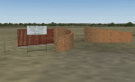
A custom made Marble Hall Airfield (FAMI), Limpopo, South Africa with photoreal textures and photoreal ground.
The small airfield has been recreated with custom true to life models and photoreal textures. Some of the buildings on the approach to rwy 22 (and even the road-signs) have been modelled with custom true to life models with photoreal textures and the marble works next to the airfield is also included with custom models and custom textures. The airfield is mostly used by cropdusters and as an added bonus, two static cropdusters are included with the kind permission of their respective developers (a Piper PA-25 Pawnee by Andy Strukowsi and a Turbo Thrush by Marcel du Plessis). Both planes are flyable aircraft (see download details in Readme file) which were converted to static aircraft models by myself.
The paved runway is aligned 04/22 and 1 000m long and sits at an elevation of 3 000ft.
| Filename: | Marble_Hall_FAMI_South_Africa.zip |
| License: | Freeware, limited distribution |
| Added: | 24th November 2017, 17:17:06 |
| Downloads: | 213 |
| Author: | Kobus van Wyk & Morne van Wyk |
| Size: | 8.3 MB |
| Category: Flight Simulator 2004 - Scenery | |
| Minneapolis St. Paul MSP / KMSP, Version 5.0 |
|
Images related to this file:
File Description:

Thank you for downloading this scenery. This is a major rebuild of Minneapolis/St Paul International airport. All default elements of the main terminal and cargo ramps have been replaced. The Humphrey terminal as well as runway 17/35 have been added. The included AFCAD will activate rwy 17/35 during normal runway 12's/30's ops. When conditions call for rwy 4/22, traffic will really stack up. Also included are 2 bgl files which add the ILS for rwy 35 and changes some of the ground texture and elevation around the airport. All gates are laid out per the MSP website and sat photos.
Version 5 has an all new AFCAD file by AFX with all taxiway signs in place, and all taxiways correctly named. Also parking has been updated to compensate for the Delta/Northwest merger. There are several modifications to the cargo ramps and maintainance areas as well.
| Filename: | Minneapolis_St_Paul_MSP__KMSP_Version_50.zip |
| License: | Freeware |
| Added: | 20th May 2010, 08:56:00 |
| Downloads: | 15,183 |
| Author: | William Morgan, FRFSTUDIO.NET |
| Size: | 14.57 MB |
| Category: Flight Simulator 2004 - AFCAD Files | |
| 113 AFCAD Files. FINAL RELEASE |
|
File Description:
M and K Studios is Very Proud to present our final release... However, not so final, we have descided to release this package, in order to anticipate and build off for our next release.... Includes over 113 AFCAD Files.... These files took over 2 months to complete and each airport was manually and painstakingly put together. Airports like KDEN (Denver) now have Runway 34L/16R, it is a 16000X200 FT Runway, that we designed with accurate Taxiways and with FULL Autoland, LAND3 ILS Certified Runway. Even better, each airport below has accurately parking spots aligned with their respective gates, EVEN BETTER THAN THAT. each airport has accurate Airline and parking spot placing in accordance with the FAA Database... The following airports below are the airports included in this file.... KABQ KADW KAFW KIAD KALB KAPA KBDL KBGR KBIL KBKL KBOI KBTL KBUR KCAE KCHS KCLE KCLT KCMH KCRP KCWF KCYS KDAL KDAY KDEN KDFW KDPA KDTW KEDW KELM KELP KEWR KFTW KFWA KGRR KGSO KGTF KHND KHPN KHWD KIAD KIAH KICT KILG KIND KIWA KJFK KLAN KLAS KLAX KLFT KLGA KLGB KLNK KLSV KLTS KLZU KMCN KMCO KMHR KMHT KMIA KMKE KMMU KMOT KMSP KMSY KMTN KNIP KOAK KOKC KONT KORD KPDX KPHL KPHX KPIT KPNS KPTK KPWM KRBD KRDU KRIV KSAF KSAN KSAT KSAV KSDF KSEA KSFO KSJC KSMF KSNA KSTP KSYR KTEB KTOL KVGT KVNY KCVG KMDW KBNA KMEM KSTL KTPA KDAB KPBI KATL KDCA KIAD KBWI KPHL KLGA KCHS KRNO KSLC... If that isnt alot of airports i dont know what is.... thank you for your download..... Thanks you. By Kylan Walters, Marcus Mosby, Our Beta Team, and the rest of the Team... (Origonal File Held 3274 Downloads in all)
| Filename: | 113_AFCAD_Files_FINAL_RELEASE.zip |
| License: | Freeware |
| Added: | 2nd August 2007, 03:18:05 |
| Downloads: | 25,918 |
| Author: | By: Kylan Walters |
| Size: | 3.88 MB |
| Category: Flight Simulator 2004 - Scenery | |
| "Himalayan Peaks" LOD10 Mesh, Volume 8 - Tirich Mir and Pamir |
|
Images related to this file:
File Description:
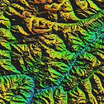
Highly detailed terrain mesh of the Tirich Mir and Pamir areas, N36-39 E71-74. The files in this package are based on Shuttle Radar (SRTM) Version 2 data but with many of the void areas, especially the most significant sections, filled with elevation data generated from topographic maps by Jonathan de Ferranti. While Jonathan's work is unrelated to flight simulation he kindly gave me permission to compile his data for use in FS. The result is a wonderful improvement in detail and accuracy over any existing mesh file, freeware or commercial, based on SRTM or DTED data alone.
Due to the large area of the Himalayas I've compiled the source data as two separate series: the "Himalayan Peaks" series covers prominent mountains and ranges in higher detail and locally overrides any existing LOD9 terrain mesh. In addition, a LOD9 "base mesh" series covering the entire Himalayas will be available for those who do not yet have an add-on terrain mesh of these beautiful mountains.
| Filename: | Himalayan_Peaks_LOD10_Mesh_Volume_8__Tirich_Mir_an.zip |
| License: | Freeware, limited distribution |
| Added: | 29th May 2010, 08:52:47 |
| Downloads: | 9,103 |
| Author: | Holger Sandmann, Jonathan de Ferranti |
| Size: | 47.94 MB |
| Category: Navigation and ATC - Navigation | |
| LSZS - Samedan visual approach chart v3 |
|
Images related to this file:
File Description:
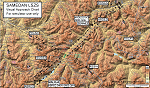
Custom made visual approach chart and pilot's briefing for Engadin (St. Moritz) Samedan LSZS airport in Switzerland, Europe's highest elevation airport (5,600 ft.) situated in the Swiss Alps. This airport is a day VFR operations only and has no instrument approach due to extreme terrain around it. A demanding visual descent into a canyon, in between steep rising terrain, is required to make the visual approaches for both runways with a steep 4.4* degrees final approach portion guided by the PAPI's. Still, executive jets up to Boeing 737(BBJ) size approach the airport often in the winter peak season VFR with these procedures. It is designed as per real operators' pilot briefing for Samedan. Real airport's full pilot briefing document also included. The real airport's excellent briefing (included) intentionally does not contain the maneuvers needed for the approach of jets through the mountains but only reporting points for all and maneuvers for light aircraft only. This gap is what this chart covers. Version 2 chart included better graphics and refined visual procedure for jets and version 3 now includes real pilot's briefing guide.
| Filename: | LSZS__Samedan_visual_approach_chart_v3.zip |
| License: | Freeware, limited distribution |
| Added: | 20th March 2015, 23:35:11 |
| Downloads: | 2,026 |
| Author: | Kyprianos Biris |
| Size: | 7.1 MB |
| Category: Flight Simulator X - AFCAD Files | |
| CYKA - Kamloops Airport / Kamloops, British Columbia, Canada (v1.2) |
|
Images related to this file:
File Description:
This airport update was made with the latest version of ADE (Airport Design Editor) and made for FSX as a replacement for the stock (default) airport. I've made several changes to the airport which are listed below. All these enchancements are as close to the real airport as I can get with stock library objects. I've used satellite images, terminal photos and maps throughout the whole process so building locations are as accurate as possible. Happy landings in beautiful Canada!
Features:
*Expanded parking apron
*Main terminal building with parking for commercial traffic (renumbered correctly v1.2)
*Seperate parking aprons for GA traffic
*Helipad
*Hangar and other airport buildings added
*Airport vehicles and objects throughout the airport
*Parking lots with static vehicles
*Airport fire station with fire truck
*Static de-icing vehicles & runway plow
*Static aircraft/helicopters
*Corrected communication frequencies (v1.1)
*Recent runway expansion to 8,000ft (v1.2)
*New taxiway Foxtrot,Golf (v1.2)
*New ILS for runway 08 (v1.2)
*Corrected tower elevation bug (v1.2)
(For more information on Endeavourai please visit our site at endeavourai.com or our forums at http://endeavourai.boards.net/)
| Filename: | CYKA__Kamloops_Airport__Kamloops_British_Columbia_.zip |
| License: | Freeware |
| Added: | 9th August 2012, 17:15:56 |
| Downloads: | 736 |
| Author: | Jaison Diaz / Endeavour ai |
| Size: | 127.44 KB |
| Category: Flight Simulator X - Missions | |
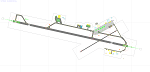
| Challenging Approach: Innsbruck, Austria, LOWI |
|
File Description:
This is the first in a series of missions on challenging approaches and landings. The mission begins with you are approaching SBG VOR, enroute to Innsbruck, Austria, LOWI. As you approach Rattenberg NDB, ATC commands 200 KIAS and 9500' to intercept RTT (Goal 1). You are also advised to enter a holding pattern at RTT, your fix, to allow time for snow removal from the runway. The pattern is standard right-hand turns with 1.5 minute legs and 200 knots at 9500'. The inbound track is 226°, while outbound is 46°. Winds are high, so you will have to compensate to stay aligned in the pattern and certify (Goal 2). Next up is to achieve a stabilized approach on the steep glide slope to runway 25 as Goal 2. The final goal is a safe full stop landing on runway 26 at elevation 1894' The descent is near 4° gradient and the runway VOR (111.1) is offset to the right, thus the “challengeâ€. Complete all three goals and you certify to fly to LOWI and receive a Reward.
| Filename: | Challenging_Approach_Innsbruck_Austria_LOWI.zip |
| License: | Check within download |
| Added: | 6th May 2023, 13:41:36 |
| Downloads: | 108 |
| Author: | Jake Rogers |
| Size: | 10.73 MB |
© 2001-2026 AVSIM Online
All Rights Reserved
Privacy Policy |