
Where Flight Simulation Enthusiasts Gather from Around the World!
AVSIM Library - Search Results

| Category: Flight Simulator 2004 - Scenery | |
| Howick Airfield (FAHC), South Africa |

|
Images related to this file:
File Description:
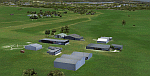
This package will add a custom (Gmax) made Howick Airfield (FAHC), KwaZulu Natal, South Africa with photoreal textures and seasonal ground textures.
Howick is a small town in the KwaZulu Natal Midlands just off the N3 freeway which connects Johannesburg and Durban and home to the famous Howick waterfall. The Umgeni river falls 95m (311 ft) over the cliffs on the way to the Indian Ocean. The town is also home to the Midmar dam. This dam is very well known as being the location of the annual Midmar Mile swimming event which, in 2009, was recognized by the Guinness Book of World Records as the world's largest open water swimming event with 13 755 competitors taking part.
The sloped grass runway is aligned 16/34 and 825m long and sits at an elevation of 3 615ft. Both runways have obstacles on the approach, with powerlines 730m from the threshold of runway 16, while runway 34's approach have hills around 900m before the threshold. The sloped runway has been created in FS2004 within the limits of the simulator itself.
| Filename: | Howick_Airfield_FAHC_South_Africa.zip |
| License: | Freeware, limited distribution |
| Added: | 15th January 2021, 20:25:51 |
| Downloads: | 200 |
| Author: | Kobus van Wyk |
| Size: | 7.67 MB |
| Category: Flight Simulator 2004 - Scenery | |
| Himalayas LOD9 Base Mesh, Volume 1 - Southeastern Ranges |
|
Images related to this file:
File Description:
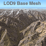
Detailed terrain mesh of the Southeastern Himalayan Ranges, N26-32 E90-98. The files in this package are based on Shuttle Radar (SRTM) Version 2 data but with many of the void areas, especially the most significant sections, filled with elevation data generated from topographic maps by Jonathan de Ferranti. While Jonathan's work is unrelated to flight simulation he kindly gave me permission to compile his data for use in FS. The result is a wonderful improvement in detail and accuracy over any existing mesh file, freeware or commercial, based on SRTM or DTED data alone.
Due to the large area of the Himalayas I've compiled the source data as two separate series: the "Himalayan Peaks" series covers prominent mountains and ranges in higher detail and locally overrides any existing LOD9 terrain mesh. In addition, a LOD9 "base mesh" series, with LOD8 and LOD7 "buffer" mesh files, covering the entire Himalayas, is meant for those who do not yet have an add-on terrain mesh of these beautiful mountains.
| Filename: | Himalayas_LOD9_Base_Mesh_Volume_1__Southeastern_Ra.zip |
| License: | Freeware, limited distribution |
| Added: | 29th May 2010, 09:01:26 |
| Downloads: | 10,298 |
| Author: | Holger Sandmann, Jonathan de Ferranti |
| Size: | 71.82 MB |
| Category: Flight Simulator 2004 - Scenery | |
| Himalayas LOD9 Base Mesh, Volume 2 - Southcentral Ranges |
|
Images related to this file:
File Description:

Detailed terrain mesh of the Southcentral Himalayan Ranges, N26-32 E82-90. The files in this package are based on Shuttle Radar (SRTM) Version 2 data but with many of the void areas, especially the most significant sections, filled with elevation data generated from topographic maps by Jonathan de Ferranti. While Jonathan's work is unrelated to flight simulation he kindly gave me permission to compile his data for use in FS. The result is a wonderful improvement in detail and accuracy over any existing mesh file, freeware or commercial, based on SRTM or DTED data alone.
Due to the large area of the Himalayas I've compiled the source data as two separate series: the "Himalayan Peaks" series covers prominent mountains and ranges in higher detail and locally overrides any existing LOD9 terrain mesh. In addition, a LOD9 "base mesh" series, with LOD8 and LOD7 "buffer" mesh files, covering the entire Himalayas, is meant for those who do not yet have an add-on terrain mesh of these beautiful mountains.
| Filename: | Himalayas_LOD9_Base_Mesh_Volume_2__Southcentral_Ra.zip |
| License: | Freeware, limited distribution |
| Added: | 29th May 2010, 09:05:56 |
| Downloads: | 9,447 |
| Author: | Holger Sandmann, Jonathan de Ferranti |
| Size: | 90.25 MB |
| Category: Flight Simulator 2004 - Scenery | |
| Himalayas LOD9 Base Mesh, Volume 4 - Kashmir and Jammu |
|
File Description:
Detailed terrain mesh of the Kashmir and Jammu Ranges, N30-39 E76-78. The files in this package are based on Shuttle Radar (SRTM) Version 2 data but with many of the void areas, especially the most significant sections, filled with elevation data generated from topographic maps by Jonathan de Ferranti. While Jonathan's work is unrelated to flight simulation he kindly gave me permission to compile his data for use in FS. The result is a wonderful improvement in detail and accuracy over any existing mesh file, freeware or commercial, based on SRTM or DTED data alone.
Due to the large area of the Himalayas I've compiled the source data as two separate series: the "Himalayan Peaks" series covers prominent mountains and ranges in higher detail and locally overrides any existing LOD9 terrain mesh. In addition, the LOD9 "base mesh" series, with LOD8 and LOD7 "buffer" mesh files, covering the entire Himalayas, is meant for those who do not yet have an add-on terrain mesh of these beautiful mountains.
| Filename: | Himalayas_LOD9_Base_Mesh_Volume_4__Kashmir_and_Jam.zip |
| License: | Freeware, limited distribution |
| Added: | 22nd February 2006, 20:32:50 |
| Downloads: | 7,503 |
| Author: | Holger Sandmann, Jonathan de Ferranti |
| Size: | 29.24 MB |
| Category: Flight Simulator 2004 - Scenery | |
| Himalayas LOD9 Base Mesh, Volume 3 - Southwestern Ranges |
|
Images related to this file:
File Description:

Detailed terrain mesh of the Southwestern Himalayan Ranges, N28-37 E78-82. The files in this package are based on Shuttle Radar (SRTM) Version 2 data but with many of the void areas, especially the most significant sections, filled with elevation data generated from topographic maps by Jonathan de Ferranti. While Jonathan's work is unrelated to flight simulation he kindly gave me permission to compile his data for use in FS. The result is a wonderful improvement in detail and accuracy over any existing mesh file, freeware or commercial, based on SRTM or DTED data alone.
Due to the large area of the Himalayas I've compiled the source data as two separate series: the "Himalayan Peaks" series covers prominent mountains and ranges in higher detail and locally overrides any existing LOD9 terrain mesh. In addition, the LOD9 "base mesh" series, with LOD8 and LOD7 "buffer" mesh files, covering the entire Himalayas, is meant for those who do not yet have an add-on terrain mesh of these beautiful mountains.
| Filename: | Himalayas_LOD9_Base_Mesh_Volume_3__Southwestern_Ra.zip |
| License: | Freeware, limited distribution |
| Added: | 30th May 2010, 10:00:26 |
| Downloads: | 155,808 |
| Author: | Holger Sandmann, Jonathan de Ferranti |
| Size: | 62.16 MB |
| Category: Flight Simulator 2004 - Scenery | |
| Himalayas LOD9 Base Mesh, Volume 5 - Hindu Kush and Pamir |
|
Images related to this file:
File Description:

Detailed terrain mesh of the Hindu Kush and Pamir Ranges, N32-40 E70-76. The files in this package are based on Shuttle Radar (SRTM) Version 2 data but with many of the void areas, especially the most significant sections, filled with elevation data generated from topographic maps by Jonathan de Ferranti. While Jonathan's work is unrelated to flight simulation he kindly gave me permission to compile his data for use in FS. The result is a wonderful improvement in detail and accuracy over any existing mesh file, freeware or commercial, based on SRTM or DTED data alone.
Due to the large area of the Himalayas I've compiled the source data as two separate series: the "Himalayan Peaks" series covers prominent mountains and ranges in higher detail and locally overrides any existing LOD9 terrain mesh. In addition, the LOD9 "base mesh" series, with LOD8 and LOD7 "buffer" mesh files, covering the entire Himalayas, is meant for those who do not yet have an add-on terrain mesh of these beautiful mountains.
| Filename: | Himalayas_LOD9_Base_Mesh_Volume_5__Hindu_Kush_and_.zip |
| License: | Freeware, limited distribution |
| Added: | 29th May 2010, 08:57:29 |
| Downloads: | 7,603 |
| Author: | Holger Sandmann, Jonathan de Ferranti |
| Size: | 85.72 MB |
| Category: Flight Simulator 2004 - Scenery | |
| Ivujivik CYIK in Hudson Bay, Quebec, Canada |
|
Images related to this file:
File Description:
Ivujivik is a village of 350 or so inhabitants at N62 25 W78 on the northeastern corner of Hudson Bay. The village does not feature in FS9 but is included in this scenery with approximately the right shape (the coast, even with UT, is not exactly right) so just think of it as a hand-made auto-generated village which gives the airfield a reason. The runway is 3,500 feet of gravel 100 feet wide, which should be enough. I also added the roads, deleted the stock airfield background and added a new background, plus of course there is the scenery file and the AFCAD and AI. You may note that the terminal has the elevation written on the sign as 126', while on the winter photo it is written on the older & bigger sign as 130'. I thought this is because satellite radar has fixed the elevations of all airfields more accurately than before, as Rockcliffe too has gone from 192' to 188'; the alternative explanation is that global warming has raised sea level by 4'. Wow! That's a thought. I presume the new sign was made smaller as a cost saving.
| Filename: | Ivujivik_CYIK_in_Hudson_Bay_Quebec_Canada.zip |
| License: | Freeware, limited distribution |
| Added: | 31st October 2010, 07:41:20 |
| Downloads: | 457 |
| Author: | Roger Wensley |
| Size: | 2.07 MB |
| Category: Flight Simulator 2004 - Scenery | |
| North Haledon Lite |
|
File Description:
This is Chopper Friendly scenery, folks. It wasn't designed to be flown over at 10,000 feet - although, if you like to fly heavy iron into the major New York/New Jersey airports, you'll notice that it replaces the terrain elevation of Northern New Jersey with all the hills and valleys that the default scenery left out. No, this is interactive scenery. Built to be explored low and slow.
Want to perfect your landing skills in a huge playground of rooftops, irregular terrain, and tight spaces? This is the place. You won't find any unlandable surfaces or false crashes here - just hundreds of places to touch down ranging from beginner, through expert, to downright sick!
This is the lite version, designed for people who are having trouble with the frame rates of the full version. I've thinned out the houses and trees, and removed the buildings South of Oldham Pond - but managed to keep most of the interesting places to land. In the tests I've done, there was about a 20 percent frame rate increase on average compared to the full version, with nearly a 45 percent increase in the most framerate-hostile areas.
| Filename: | North_Haledon_Lite.zip |
| License: | Freeware, limited distribution |
| Added: | 1st June 2006, 04:48:01 |
| Downloads: | 656 |
| Author: | Mick Posch |
| Size: | 11.38 MB |
| Category: Flight Simulator 2004 - Scenery | |
| Inyokern Airport, Inyokern CA. , USA - Version 3 |
|
Images related to this file:
File Description:

FS2004 Scenery for Inyokern Airport (KIYK). SORRY everyone there were some libraries and textures missing from the recent release. This package contains all missing objects and libraries and is a complete replacement for ANY of my Inyokern sceneries previously installed, no other download required. (Nestled on the sunny side of the southern Sierras, Inyokern is a great jumping-off place for hi desert adventures. Known for decades for it's great soaring spots, Inyokern itself is busy enough with an average of 80 flights a day including it's United/Skywest commuter flights and occasional military traffic from the nearby China Lake Naval Weapons Test Center. Geographically, the airport is situated in the high desert of Southern California, 100 miles east-northeast of the county seat in Bakersfield, 80 miles north-northeast of the Lancaster and Palmdale areas, and 120 miles north-northwest of San Bernardino. The airport itself covers 1,640 acres at an elevation of 2,457 feet, with three asphalt paved runways that can accommodate almost any class of civilian, commercial, or military aircraft. Inyokern Airport is served by commercial airlines connecting through Los Angeles International Airport.)
| Filename: | Inyokern_Airport_Inyokern_CA__USA__Version_3.zip |
| License: | Freeware, limited distribution |
| Added: | 10th November 2013, 23:32:02 |
| Downloads: | 2,055 |
| Author: | John Stinstrom |
| Size: | 6.36 MB |
| Category: Flight Simulator X - Scenery | |
| Extreme Westgreenland |
|
File Description:
Extreme Westgreenland
Terrain Mesh for Greenland for Microsoft Flight Simulator X
Everybody who flies in Greenland knows, how incorrect the default scenery is.
This is a new terrain mesh scenery which covers Westgreenland - from Lat N 65 to N 68.
As SRTM data do not cover above N 60 - no Greenland mesh scenery has been produced.
This is one of the most detailed Greenland terrain mesh released up to release date of this scenery.
This great package covers more than 50.000 sq. km. area. This includes:
* LOD11 Mesh (terrain/elevation)
* Redesigned coastline
* Redesign lakes
R E S O U R C E S
Flightsim.gl sceneries for Microsoft Flight Simulator
http://www.flightsim.gl
Flightsim.gl updates, support and official website
http://www.flightsim.gl
N O T E S
This product including all files contained within this package is copyright © Flightsim.gl (www.flightsim.gl).
The information provided within this document and the Flightsim.gl Extreme Westgreenland scenery package is
not intended for real world navigation. All trademarks and/or logos mentioned and/or displayed within this
scenery package are property of their respective holders and are being used solely with the purpose of
representing reality.
| Filename: | Extreme_Westgreenland.zip |
| License: | Freeware, limited distribution |
| Added: | 22nd December 2007, 01:31:21 |
| Downloads: | 3,664 |
| Author: | Ulrik Motzfeldt |
| Size: | 44.95 MB |
© 2001-2026 AVSIM Online
All Rights Reserved
Privacy Policy |