
Where Flight Simulation Enthusiasts Gather from Around the World!
AVSIM Library - Search Results

| Category: Orbiter - Spaceships | |
| Vanguard 1 Add-on for Orbiter |

|
File Description:
Originally a simple nose cone was to be carried aloft, but in July of 1957 it was decided that a small 1.47 kilogram (3.25 pound) test satellite would be used instead to exercise the tracking stations. This test satellite would consist of a simple 16 centimeter (6.4 inch) polished aluminum alloy sphere equipped with two transmitters operating at frequencies around 108 MHz, 6 small solar panels, and 6 dowel like antennas.
The satellite was Vanguard I, in which its successes set the pattern for a multitude of other space ventures in this country and abroad. Vanguard also served as a springboard for scientists to launch several series of space probes to study various aspects of radiation phenomena.
Vanguard I introduced much of the technology that has been applied in other U.S. satellite programs. For example, it proved that solar cells could be used for several years to power radio transmitters. Vanguard's solar cells operated for about seven years, while conventional batteries used to power another onboard transmitter lasted only 20 days.
Now the oldest man-made satellite still in orbit to this day, Vanguard I has been 100 percent successful in meeting all its scientific objectives.
Now you can fly this historical satellite in orbit. Unlike all the US Navy failed attempts, the Orbiter version will always get you there.
| Filename: | Vanguard_1_Addon_for_Orbiter.zip |
| License: | Freeware |
| Added: | 27th September 2004, 16:23:56 |
| Downloads: | 507 |
| Author: | Jim Williams |
| Size: | 1.25 MB |
| Category: Flight Simulator 2004 - AI Aircraft | |
| Sky Airline Airbus A319-111 CC-AFY |
|
Images related to this file:
File Description:

Sky Airline is an airline based at Comodoro Arturo Merino Benitez International Airport in Santiago, Chile.
It is the second largest airline in the country behind rival LAN Airlines. It has international routes to Peru, Argentina, Bolivia and Brazil. It operates under a semi-low cost model, although its service is superior compared to other European or US low cost carriers.
It also operates charter flights in Chile and South America. Source Wiki. //
Flightplans may be available on AVSIM/Flightsim.com.
This works for both FS9 and FSX. Tested in FSX. FS9 model used.
For FSX users make sure you have UNCHECKED "Aircraft casts shadows on the ground" under the Aircraft - Exterior Settings in FSX to make any FS9-based model visible during the day!
Texture quality; FSX Native: DDS DXT5 with alpha. FS9 Native: BMP DXT3 with alpha.
FSX Light Fix included in the DDS night texture.
Custom Light Map. Custom Shadows, Highs, Weathering as usual...
Included repaint is for the following model; DJC_A319 from DJC.
By renaming the texture files to "EvolveAI_A319_CFM_T & EvolveAI_A319_CFM_L" it will also work for EvAI's model.
This is a non-reflective model.
Model is available on AVSIM and FlightSim.com or on the author/developers site.
You need the basekit for this to work!!
Do make sure you copy the texture folder(s) in the respective folder.
| Filename: | Sky_Airline_Airbus_A319111_CCAFY.zip |
| License: | Freeware, limited distribution |
| Added: | 22nd July 2012, 15:11:11 |
| Downloads: | 959 |
| Author: | Stephan Faessler / ImpulseAI |
| Size: | 1.45 MB |
| Category: Flight Simulator X - AI Aircraft | |
| Sky Airline Airbus A319 (CC-AFY) |
|
Images related to this file:
File Description:

Sky Airline is an airline based at Comodoro Arturo Merino Benitez International Airport in Santiago, Chile.
It is the second largest airline in the country behind rival LAN Airlines. It has international routes to Peru, Argentina, Bolivia and Brazil.
It operates under a semi-low cost model, although its service is superior compared to other European or US low cost carriers.
It also operates charter flights in Chile and South America. Source Wiki.
Flightplans may be available on AVSIM/Flightsim.com.
This works for both FS9 and FSX. Tested in FSX. FS9 models used.
For FSX users make sure you have UNCHECKED "Aircraft casts shadows on the ground" under the Aircraft - Exterior Settings in FSX to make any FS9-based model visible during the day!
Texture quality; FSX Native: DDS DXT5 with alpha. FS9 Native: BMP DXT3 with alpha.
FSX Light Fix included in the DDS night texture.
Custom Light Map. Custom Shadows, Highs, Weathering as usual...
Included repaint is for the following model; DJC_A319 from DJC.
By renaming the texture files to "EvolveAI_A319_CFM_T & EvolveAI_A319_CFM_L" it will also work for EvAI's model.
This is a non-reflective model.
Model is available on AVSIM and FlightSim.com or on the author/developers site.
You need the basekit for this to work!!
Do make sure you copy the texture folder(s) in the respective folder.
| Filename: | Sky_Airline_Airbus_A319_CCAFY.zip |
| License: | Freeware, limited distribution |
| Added: | 13th July 2012, 16:14:22 |
| Downloads: | 404 |
| Author: | Stephan Faessler, ImpulseAI |
| Size: | 1.45 MB |
| Category: Flight Simulator X - Scenery | |
| FSX An Idaho Mountain Flying adventure |
|
Images related to this file:
File Description:

Welcome to the Heart of Idaho!
The mountain country has to be seen to be believed. As one who grew up exploring
this part of the US I had the fortunate opportunity to do things that most just dream about. Who wouldn't want to
swim in hot-spring fed lakes, or pools? Idaho has more hot springs than any other state. Have you ever climbed up
to a pass at 10,000 feet? And then looked down at those who chose not to climb 1500 feet below, looked left at your
brother, and then looked over the pass at the mountain basin that begged to be explored. I did these things 58 years
ago. You can do it tomorrow if you want to.
This FSX adventure will take you to many places I have visited. It will also take you to places that I have not yet
visited. Some of the strips are difficult to get into. That is typical of mountain flying. Some are reasonable.
Your flying skills will be tested as you figure out the best approach.
The simulation consists of 19 airports in Central Idaho. Twelve existing strips have had improvements consisting of
strip surface improvements to allow all-season activity, and some eye candy. Seven new air facilities have been
added to the area.
| Filename: | FSX_An_Idaho_Mountain_Flying_adventure.zip |
| License: | Freeware, limited distribution |
| Added: | 29th January 2019, 18:38:19 |
| Downloads: | 189 |
| Author: | Brett Delana |
| Size: | 3.94 MB |
| Category: Flight Simulator X - Scenery | |
| Slovenia - LOD11 (19 meters resolution) Mesh |
|
Images related to this file:
File Description:

Slovenia, no matter how small, is a country with wide variety of landscapes.
From flat lands in the North-Eastern part one can see lovely rolling hills in
southern regions and razor sharp edges of 8500 ft peaks of the Alps in the
North-Western region.
SRTM elevation data that was used and is provided as default FS X terrain simply
can't cope with the task of representing our terrain in at least a little close
to reality manner, shapes and altitudes of some of our nicest peaks are deformed
beyond recognition, our highest mt. Triglav is with 38 meters SRTM mesh falling
short by almost 3000 ft!
So Slovenia Scenery Team developed this 19 meters resolution using FSX compatible
tools for it's payware scenery, but after development of even finer mesh with 10
meters resolution, we decided to offer the original 19 meters mesh to general
fligt simulation public. Mesh is FS X only and is not compatible with FS9.
Even if released as freeware, this files were uploaded to only some selected
flight simulation sites and redistribution of this scenery is not allowed without
written permission from the authors.
File is packed into a convenient installer that should perform all of the actions
automatically, but, please, do read the License agreement and "Read me" file
included in the installation.
| Filename: | Slovenia__LOD11_19_meters_resolution_Mesh.zip |
| License: | Freeware, limited distribution |
| Added: | 15th May 2012, 19:03:19 |
| Downloads: | 2,214 |
| Author: | SST - Slovenia Scenery Team |
| Size: | 45.15 MB |
| Category: Flight Simulator X - Scenery | |
| SKBO - El Dorado International Airport (2013) |
|
File Description:
El Dorado International Airport (IATA: BOG, ICAO: SKBO) is an international airport located in Bogota, Colombia. It is the largest Latin America airport in terms of cargo movements with 593,946 tons (2010) and the third in terms of
passenger traffic, only behind Sao Paulo-Guarulhos International Airport and Mexico City's Benito Juarez International Airport, transporting 18,934,203 passengers in 2010; as well as the largest airport in Colombia and the main
international and domestic air gateway in the country, serving as an important hub for Avianca, Copa Airlines Colombia, Aires, Satena, EasyFly and other cargo companies.
This file has the right coordinates, with the apron and characteristics of the airport with the new international terminal just builed in 2012. The runways were reoriented to the correct direction, runway were resized the gates placed on correct location and number, CATAM was placed
(Colombian Air force and Colombian National Army) and Colombia National Police and Colombian National Armada were assigned a correct apron. All the jet ways including the ones of the executive terminal are working. There is a copy
of all the airport charts required to navigate in and out of this airport which are courtesy of: Areonatica Civil de Colombia and the originals can be found at www.aerocivil.gov.co/ under Informacion Aeronautica click AIP; on AIP
click Aerodromos then click at SKBO.
This work is dedicated to West Wind Airlines.
| Filename: | SKBO__El_Dorado_International_Airport_2013.zip |
| License: | Freeware |
| Added: | 16th February 2013, 00:10:34 |
| Downloads: | 11,216 |
| Author: | Anwar Gonzalez |
| Size: | 19.16 MB |
| Category: Flight Simulator X - Aircraft Repaints, Textures and Modifications | |
| B-24 USAAF 376th BG "Lady be Good" |
|
File Description:
Following an April 4, 1943 bombing raid on Naples, Italy, conducted by the 376th Bomb Group, the Lady Be Good of the 514th Bomb Squadron failed to return to base. After attempts to locate the plane, its nine crewmen were classified as MIA, and presumed dead, believed to have perished after crashing in the Mediterranean.
Almost 16 years later on Nov. 9, 1958, several British geologists were flying over the desolate, sun-baked Libyan Desert. At approximately 400 miles south of Soluch, they spotted an aircraft on the sand. A ground party that reached the site in March 1959 discovered the plane to be a B-24D. The "Lady Be Good" had been found.
Evidence at the site indicated that the crew had become lost in the dark on return from Naples and had flown over their base and southward into the desert. As their fuel supply became depleted, the nine men aboard had bailed out but had disappeared while attempting to walk northward to civilization.
Intensive searches were made for clues as to the fate of the crew, and in 1960 the remains of eight were found, one near the plane and the other seven far to the north. Five had trekked 78 miles across the tortuous sand before perishing and one had gone an amazing 109 miles. In addition, they had lived eight days rather than only two expected of men in this area with little or no water. The body of the ninth man was never found.
Repaint for the Alphasim B-24 by Jan Kees Blom.
| Filename: | B24_USAAF_376th_BG_Lady_be_Good.zip |
| License: | Freeware |
| Added: | 11th October 2008, 13:11:09 |
| Downloads: | 386 |
| Author: | Jan Kees Blom |
| Size: | 7.61 MB |
| Category: Flight Simulator 2004 - Scenery | |
| Steamboat Springs (KSBS), Flat Tops Wilderness Area, Colorado - Photo-Scenery |
|
Images related to this file:
File Description:

Steamboat Springs (KSBS), Flat Tops Wilderness Area, Colorado, Photo-Scenery (FS9 & FSX)
The Flat Tops Wilderness Area, which is the second largest wilderness area in Colorado, is named for its many flat topped mountains that are clearly visible from the sky. Trappers Lake, located in the north of the area inspired Arthur Carhart, a US Forest Service official, to initiate a plea for Wilderness preservation as early as 1919. Finally in 1975, three years before his death in 1978, the Flat Tops were designated a wilderness area. No wonder he found the area so entrancing: Behind Trappers Lake loom majestic volcanic cliffs, and beyond them a vast subalpine terrain reluctantly yields to alpine tundra with an average elevation of about 10.000 feet. More than 100 lakes dot the country above and below numerous flat-topped cliffs. Steamboat Springs is an internationally known winter resort destination.
To explore the scenery depart from Steamboat Springs Airport (KSBS) or Yampa Valley Airport (KHDN) and head south. High resolution versions of this scenery for FS9 and FSX (much sharper, but larger and multiple downloads) are available at www.blueskyscenery.com/GNB_West2.html . The screenies are taken from the high-res versions, so expect this version to be slightly more blurry. Thanks to Joop Mak for providing custom AFCADs that correct airport layouts so that they align with the photo-textures! They are available at www.blueskyscenery.com/AFCADs.html . YourDonation@Work: Dedicated to James.
| Filename: | Steamboat_Springs_KSBS_Flat_Tops_Wilderness_Area_C.zip |
| License: | Freeware, limited distribution |
| Added: | 26th April 2010, 17:53:25 |
| Downloads: | 1,302 |
| Author: | Gottfried Razek - blueskyscenery.com |
| Size: | 91.57 MB |
| Category: Microsoft Flight Simulator (2020) - Scenery | |
| UGAM Ambrolauri Airport, Georgia [MSFS] |
|
Images related to this file:
File Description:
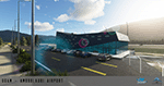
Ambrolauri Ambrolauri (Georgian: áƒáƒ›áƒ‘რáƒáƒšáƒáƒ£áƒ ი) is a city in Georgia, located in the western part of the country, on both banks of the Rioni river, at the elevation of 550 m above sea level. It is a self-governing city. At the same time, the city serves as the seat of the Racha-Lechkhumi and Kvemo Svaneti regional administration and the Ambrolauri Municipality. According to the 2014 census, the city had a population of 2,047. Its area is 1.6 km². Ambrolauri is first recorded in the 17th century as a place, where one of the palaces of the kings of Imereti was located. It acquired the city status in 1966 and became a self-governing city with its own municipal government in 2014. The Airport The airport is nestled into the Caucasus mountains right at the bank of the river Rioni. It has a single runway of 1100 m length and caters small propeller aeroplanes. The apron has space for two planes at a time and caters up to 50 passengers at one time. In the Simulator The virtual airport is very close to its real-world counterpart. All the buildings at and near the airport are modelled and the terminal even has an interior that can be seen from outside. The look and feel from a trip to the Racha region is definitely there. In real life, only small planes fly to the airport but that shouldn't stop you to bring planes from the size of the Dash 8.
| Filename: | UGAM_Ambrolauri_Airport_Georgia_MSFS.zip |
| License: | Freeware, limited distribution |
| Added: | 30th December 2020, 18:16:07 |
| Downloads: | 179 |
| Author: | David Hilker |
| Size: | 72.32 MB |
| Category: Flight Simulator X - Flight Plans | |
| ALbanian Wings Ltd..... |
|
File Description:
Durrës (Italian Durazzo), city and seaport in western Albania, capital of Durrës District, on the Adriatic Sea near Tirana is the home base of Albanian Wings Ltd. The Company is presently hiring pilots which will, if they pass the exams, fly passengers and freight to small and medium
cities in Albania. It is flying one Jet, three Turbos and several small aircraft which are good for the medium and small airfields of the country. You have applied for a Captain position and will take their test early next week. Capt. Damilov Gigko, chief of operations will give you the complete round and some:*Examples} A flight from the base field to Peshkopi up in the mountains
near what use to be Yugoslavia, a bad weather flight to the company´s Test Field 1, a very short one by the sea. Copilot to Sarande, Korce and the Lake Resorts near Greece. You will notice that many fields have been "built" by AWL since it agresively wants these markets. Pay is very good so you must do your best to pass these tests........This is DeLuxe FSAdventureSky Adventure flight with many new airfields, much eyecandy, complete PDF manual and a lot of fun!!!
This is Chapter One of Three which end on Christmas day 2008......You need the job man!!! so do some short take offs and landings before you go applying for it and mess everything up!!!! Now that money and credit is tight this is your Bonanza or Bust!!!!!
OH...yes, all your examiners are Captains and women!!!!!...Great!!!
| Filename: | ALbanian_Wings_Ltd.zip |
| License: | Freeware, limited distribution |
| Added: | 9th November 2008, 08:10:34 |
| Downloads: | 702 |
| Author: | Gera Godoy Canova |
| Size: | 3.58 MB |
© 2001-2026 AVSIM Online
All Rights Reserved
Privacy Policy |