
Where Flight Simulation Enthusiasts Gather from Around the World!
AVSIM Library - Search Results

| Category: Flight Simulator X - AFCAD Files | |
| Strawberry Fields Airport (89NJ), NJ |

|
File Description:
Located 02 miles N of Mays Landing, New Jersey on 220 acres of land, Strawberry Fields Airport is a private turf/sand strip. SkyVector lists the runway as 2200' long, but as measured during development it is closer to 3000'. In addition to Runways 14 and 32, there is a second runway that is not listed in the airport directory and presumed closed. However if you need it in an emergency the numbers are 03 and 21 (no starts are available for these runways). This airport is not lit and is best used only during daytime VFR conditions. The windsock can be found at the intersection of the two runways and is also not lit. You will be landing on bare terrain so have your mesh complexity slider set as high as possible for best effect.
Scenery constructed with use of satellite images/streetview/aerial photos - the author has not been there in person.
This scenery is meant to be used in conjunction with MegaScenery Earth New Jersey/Delaware 003. It is not required, but apron use is minimized to allow satellite scenery to show through as much as possible, and objects are placed based on the MSE textures - lack of it may make scenery look out of place.
| Filename: | Strawberry_Fields_Airport_89NJ_NJ.zip |
| License: | Freeware |
| Added: | 17th February 2011, 07:55:52 |
| Downloads: | 204 |
| Author: | Drew Sikora |
| Size: | 1.75 MB |
| Category: Flight Simulator X - AFCAD Files | |
| Bridgeport-Cahill Field Airport (6NJ9), NJ |
|
File Description:
Located 01 miles SW of Bridgeport, New Jersey on 167 acres of land, this airport is non-existent in real life, as far as I am able to determine. although it is still listed as Active, no visible trace of anything remotely suitable for a landing strip is visible anywhere in this area. The strip mining operation nearby in some satellite/aerial photos shows a long narrow grass strip that could be used as a runway, but then others show it stripped down to bare dirt as part of the apparent mining operation, and the MegaSceneryEarth textures depict this latter representation as well. So I have simply removed visible evidence of this strip, although FSX will still try to tell you it's there in the airport directory.
Scenery constructed with use of satellite images/streetview/aerial photos - the author has not been there in person.
This scenery is meant to be used in conjunction with MegaScenery Earth New Jersey/Delaware 004. It is not required, but apron use is minimized to allow satellite scenery to show through as much as possible, and objects are placed based on the MSE textures - lack of it may make scenery look out of place.
| Filename: | BridgeportCahill_Field_Airport_6NJ9_NJ.zip |
| License: | Freeware |
| Added: | 10th February 2011, 05:01:38 |
| Downloads: | 197 |
| Author: | Drew Sikora |
| Size: | 209.8 KB |
| Category: Flight Simulator X - Scenery | |
| Crosswind Runways for California Central Coast Scenery for FSX with CCFSXMSG.ZIP or CCFSXMS.ZIP Installed |
|
Images related to this file:
File Description:
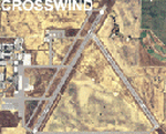
This scenery contains several revised files for my previously uploaded California Central Coast sceneries CCFSXMSG.ZIP and CCFSXMS.ZIP. These are the versions of my CCC scenery for FSX with MegaScenery Earth. The "G" version also requires Genesis Terrain Mesh but is the most complete version. Included here are revised AFCAD files for the major airports in those sceneries which will add interesting crosswind capability to C80, PRB, SBP, SMX and SBA airports. Additionaly, revised AFCAD and associated files for IZA, LPC, L52 and VBG are included. In some cases ground traffic has been added, a few glitches repaired and minor improvements effected. The crosswind AFCAD's for the 5 airports with tangential or crossing runways were revised using the technique developed by Jim Vile and executed by Airport Design Editor (ADEX). This procedure will unavoidably bolix up the ATIS runway advisories at the 3 tower controlled airports with ATIS (SBA, SBP and SMX) but will make all of the runways useable for AI traffic depending on wind conditions. This is not a problem at C80 and PRB since they are uncontrolled fields and have no ATIS available. Therefore, I've included revised AFCADs for SBA, SBP and SMX that do not have crosswind provisions that can be substituted if desired.
| Filename: | Crosswind_Runways_for_California_Central_Coast_Sce.zip |
| License: | Freeware |
| Added: | 7th January 2010, 22:05:25 |
| Downloads: | 514 |
| Author: | Al Wheeler |
| Size: | 194.42 KB |
| Category: Flight Simulator X - AFCAD Files | |
| Hackettstown Airport (N05), NJ |
|
File Description:
Located 03 miles SW of Hackettstown, New Jersey on 65 acres of land, Hackettstown Airport is a public asphalt strip 2200' in length. Fuel, tiedowns and hangars are all available for transient aircraft. For fuel, stop on the concrete pad next to the fuel tank northeast of the runway - 100LL only. Tiedowns are available both east and west of the runway - note that west parking faces the trees and if you start in one of the West Parking spots you will either need to pushback or slew to give yourself room to turn out - static aircraft collisions are off but vegetation is not. The one hangar north of the airport is open for parking, you can start there with the DOCK type parking location. This airport is not lit so daytime VFR operations only are recommended.
Scenery constructed with use of satellite images/streetview/aerial photos - the author has not been there in person.
This scenery is meant to be used in conjunction with MegaScenery Earth New York 007. It is not required, but apron use is minimized to allow satellite scenery to show through as much as possible, and objects are placed based on the MSE textures - lack of it may make scenery look out of place.
| Filename: | Hackettstown_Airport_N05_NJ.zip |
| License: | Freeware |
| Added: | 13th May 2011, 09:16:30 |
| Downloads: | 208 |
| Author: | Drew Sikora |
| Size: | 557.98 KB |
| Category: Flight Simulator X - AFCAD Files | |
| Halka Nurseries Airport (9NJ6), NJ |
|
File Description:
Located 02 miles W of Fairton, New Jersey on 150 acres of land, Halka Nurseries Airport is a private turf strip 2400' in length. The airspace has been analyzed and deemed suitable for aircraft up to a light twin. Take caution on the Runway 18 approach as power lines are strung up along the street opposite the runway. There is no hard surfaced runway so have your terrain mesh set as high as possible to experience bumpy terrain. There is no windsock, so be sure to know your weather before arriving or departing - the winds in this area are predominantly out of the west and this runway is north/south. Trees and bushes are close to some areas of the runway and can pose a danger in high crosswinds. There are no services for transient aircraft.
Scenery constructed with use of satellite images/streetview/aerial photos - the author has not been there in person.
This scenery is meant to be used in conjunction with MegaScenery Earth New Jersey/Delaware 005. It is not required, but apron use is minimized to allow satellite scenery to show through as much as possible, and objects are placed based on the MSE textures - lack of it may make scenery look out of place.
| Filename: | Halka_Nurseries_Airport_9NJ6_NJ.zip |
| License: | Freeware |
| Added: | 6th April 2011, 03:27:56 |
| Downloads: | 207 |
| Author: | Drew Sikora |
| Size: | 829.12 KB |
| Category: Flight Simulator X - AFCAD Files | |
| Paramount Air Airport JY04 , NJ |
|
File Description:
Located 01 miles N of Green Creek, New Jersey on 20 acres of land, Paramount Air Airport is a private turf strip 2000' in length, although about 300' of it at the end of Runway 32 isn't in the best shape. The runway is 100' wide but closely hedged in by trees along both sides for the length of the runway. A hangar is past the end of Runway 14 but no services are offered for transient aircraft. Still, you can choose to start parked at the hangar if you wish. There is no hard surfaced runway so having your terrain mesh set as high as possible is recommended. No windsock is present, so know your weather (KWWD is very close by) and the airport is unlit so daytime VFR operations only are recommended.
Scenery constructed with use of satellite images/streetview/aerial photos - the author has not been there in person.
This scenery is meant to be used in conjunction with MegaScenery Earth New Jersey/Delaware 005. It is not required, but apron use is minimized to allow satellite scenery to show through as much as possible, and objects are placed based on the MSE textures - lack of it may make scenery look out of place.
| Filename: | Paramount_Air_Airport__JY04__NJ.zip |
| License: | Freeware |
| Added: | 20th April 2011, 16:42:48 |
| Downloads: | 179 |
| Author: | Drew Sikora |
| Size: | 418.37 KB |
| Category: Flight Simulator X - AFCAD Files | |
| Red Lion Airport (N73), NJ |
|
File Description:
Located 02 miles S of Vincentown, New Jersey on 92 acres of land, Red Lion is a public airfield with a single asphalt runway 2880' in length. Tie downs are available at the Runway 23 end of the airport with South parking being the main tie down area. North parking is on the grass off the main taxiways and East parking is behind the main hangar near the parking lot. All parking is for aircraft with wingspans of 40' or less. Fuel is available by stopping near the tank next to the main hangar near Runway 23. PAPI for Runway 23 is out of service indefinitely, which is why you will see the PAPI boxes but no lights. All static objects and trees adjacent to the taxiways and parking spots have collision disabled.
Scenery constructed with use of satellite images/streetview/aerial photos - the author has not been there in person.
This scenery is meant to be used in conjunction with MegaScenery Earth New Jersey/Delaware 002. It is not required, but apron use is minimized to allow satellite scenery to show through as much as possible, and objects are placed based on the MSE textures - lack of it may make scenery look out of place.
| Filename: | Red_Lion_Airport_N73_NJ.zip |
| License: | Freeware |
| Added: | 9th December 2011, 14:20:51 |
| Downloads: | 171 |
| Author: | Drew Sikora |
| Size: | 1.06 MB |
| Category: Flight Simulator X - Scenery | |
| TLPC George F. L. Charles Airport Castries, Saint Lucia |
|
File Description:
George F. L. Charles Airport (TLPC) is a small airport in Saint Lucia, mostly serving the caribbean Islands. It is the airport that is situated in the north of the island in the capital city of Castries.
It serves quite a few regional airlines mainly operating turbo props like the dash8, ATR and smaller types, but has handled bigger types in the past such as MD82 (BWIA) and B722 (AMERIJET). Since stopped because of noise complaints. (SIGHS)
This is my first attempt at scenery design. I was motivated to build this scenery because I grew up near the airport and always enjoyed flying in there Whether in real or in the sim.
Since FSX, there`s been no scenery built for it and I could not stand the default scenery. So almost two years ago, not knowing a thing about scenery design and where to start, I embarked on this project. It is by no means perfect, but I think it is better than what is on offer. There are no custom ground textures cause I have not worked it out yet, maybe in a later update. The buildings where all made with Google Sketchup8 free version and converted with ModelConverterX and added to FSX with Instant Scenery 2. ENJOY.
| Filename: | TLPC_George_F_L_Charles_Airport_Castries_Saint_Lucia.zip |
| License: | Freeware |
| Added: | 14th April 2013, 13:01:54 |
| Downloads: | 1,695 |
| Author: | Finbar Lesmond |
| Size: | 13.12 MB |
| Category: Flight Simulator 2004 - Scenery | |
| Bethel PABE in southwest Alaska |
|
Images related to this file:
File Description:
There are four main northwestern Alaska towns which have good airports and are serviced by Alaska Airlines. From these airports local flights connect to nearby villages, "nearby" in Alaska meaning up to 200 miles away. The northernmost is Barrow. Southwest of Barrow is Kotzebue, then Nome, and the furthest south is this one, Bethel. The town of Bethel has a population of just over 6,000 and is 50 miles from the sea on the Kuskowim River, that splits and forks into many tributaries. Bethel Airport is close to the town and provides the only contact with the rest of Alaska, as there is no connecting highway system. There are scheduled flights by Alaska Airlines, ERA (now called Ravn) and Grant Aviation, plus others such as Ryan Air. There are cargo flights by Everts, Northern, and Lynden, and redistribution onwards to nearby villages by the smaller locally-based planes; all of these are included in the AI. There are two main runways, one just under 6,400 feet and another just under 3,900 feet, both of them aligned 19-1. The third runway is around 1,800 feet and mainly gravel, aligned 11-29. Parking at PABE is on three aprons, the northern for smaller commercial planes of Grant, ERA, Ryan etc, the central for larger planes of Alaska, Northern, Everts, and Lynden, and the southern for a large collection of GA; each apron has further hangars for maintenance companies and smaller operators. There is also another separate apron for the local military and Coastguard. There is not much photographic information available for PABE, and I have never been there; as a result it was impossible to make detailed photographic textures for some of the buildings. However, for most hangars I have made textures of at least the right colour etc based on the information I assembled and if it is green with white trim and side windows then that is how it now appears here. The exceptions are the Alaska Airlines terminal building which has complicated curved elements, and the two military hangars and workshops where I had to settle for an Alaska terminal building from another airport and the same for the military. There are numerous small villages in the vicinity of Bethel, all of them being beside either a river tributary or the coast. There are two Google Earth screenshots to show the villages that are served by the flights from Bethel and that are (mostly) included in the AI. Some of these airfields were not included in FS9 but AI will still operate in and out of Bethel. The smaller area screenshot shows the villages that are close to Bethel, and of these eight I have so far made six and they are included in this post: Napaskiak PKA, Napakiak WNA, Kwethluk KWT, Atmautluak 4A2, Nunapitchuk 16A, and Kasigluk Z09. I will work my way through the rest of the area.
| Filename: | Bethel_PABE_in_southwest_Alaska.zip |
| License: | Freeware, limited distribution |
| Added: | 8th March 2019, 00:37:58 |
| Downloads: | 303 |
| Author: | Roger Wensley |
| Size: | 32.02 MB |
| Category: Flight Simulator X - AFCAD Files | |
| Princeton Airport (39N), NJ |
|
File Description:
Located 03 miles N of Princeton/Rocky Hill, New Jersey on 100 acres of land, Princeton Airport is a public airstrip. Fuel is available by parking next to the fuel tank - make sure you leave yourself enough room to get back out! (The block of static aircraft parked near the fuel area have collision disabled). This airport offers hangar space for transient aircraft, and as such 5 hangars are open that you can park in - the large hanger and the 4 surrounding it, 2 to the north and 2 to the south. The large hangar has operating doors - the frequency to open them is posted on the hangar doors. You can also choose to start in one of the hangars by selecting a DOCK parking space when positioning yourself at the airport. Docks 16 & 17 are the two small north hangars, Dock 20 is the large central hangar and Docks 18 & 19 are the two small south hangars.
Scenery constructed with use of satellite images/streetview, the author has not been there in person.
This scenery is meant to be used in conjunction with MegaScenery Earth New Jersey/Delaware 001. It is not required, but apron use is minimized to allow satellite scenery to show through as much as possible, and objects are placed based on the MSE textures - lack of it may make scenery look out of place.
| Filename: | Princeton_Airport_39N_NJ.zip |
| License: | Freeware |
| Added: | 21st November 2010, 09:01:50 |
| Downloads: | 310 |
| Author: | Drew Sikora |
| Size: | 1.26 MB |
© 2001-2026 AVSIM Online
All Rights Reserved
Privacy Policy |