
Where Flight Simulation Enthusiasts Gather from Around the World!
AVSIM Library - Search Results

| Category: Flight Simulator X - AFCAD Files | |
| Alexandria Airport (N85), NJ |

|
File Description:
Located 02 miles W of Pittstown, New Jersey on 75 acres of land, Alexandria Airport handles small and medium GA craft as well as helicopters. The main parking area is at the southwest of the airport between the yellow lines - static aircraft are there to show you the parking arrangment. Collision with the three static aircraft in the parking area is disabled to make it easier to park next to them should you wish. AI will spawn in this area only. Craft with wingspans greater than 40 feet should not park here. There is additional space to park on the grass north of the airport and two open hangars are also available at the north tarmac. You can get fuel by stopping anywhere around the fuel tank on the east tarmac. Trees are summer ONLY.
Scenery constructed with use of satellite images/streetview, the author has not been there in person.
This scenery is meant to be used in conjunction with MegaScenery Earth New Jersey/Delaware 001. It is not required, but apron use is minimized to allow satellite scenery to show through as much as possible, and objects are placed based on the MSE textures - lack of it may make scenery look out of place.
| Filename: | Alexandria_Airport_N85_NJ.zip |
| License: | Freeware |
| Added: | 21st October 2010, 04:11:13 |
| Downloads: | 281 |
| Author: | Drew Sikora |
| Size: | 395.96 KB |
| Category: Flight Simulator X - AFCAD Files | |
| Flying W Airport (N14), NJ |
|
File Description:
Located 01 miles SW of Lumberton, New Jersey on 170 acres of land, Flying W Airport services small to medium GA aircraft as well as helicopters. Transient storage are tie downs only. There are plenty of places to park. The main parking area in on the west side of the airport on the south end of the north tarmac and can handle wingspans of up to 50 feet. You can also park slightly north among the static aircraft or east of the runway on the grass. Collisions are disabled with static craft in these areas to assist with parking. Both 100LL and Jet-A are available by stopping at the south tarmac next to the fuel tank or the north tarmac by the fuel trucks in front of the terminal. Trees are summertime ONLY.
Scenery constructed with use of satellite images/streetview, the author has not been there in person.
This scenery is meant to be used in conjunction with MegaScenery Earth New Jersey/Delaware 002. It is not required, but apron use is minimized to allow satellite scenery to show through as much as possible, and objects are placed based on the MSE textures - lack of it may make scenery look out of place.
| Filename: | Flying_W_Airport_N14_NJ.zip |
| License: | Freeware |
| Added: | 24th October 2010, 18:53:47 |
| Downloads: | 217 |
| Author: | Drew Sikora |
| Size: | 805.7 KB |
| Category: Flight Simulator 2004 - Scenery | |
| Peawanuck CYPO / Winisk CYWN - Northern Ontario, Canada |
|
Images related to this file:
File Description:
Peawanuck is on the bank of the Winisk River, 23 miles upstream from where the river empties into the Hudson Bay just west of James Bay. It has a population of around 240, and was established in 1986 when the original settlement (Winisk) at the mouth of the river was destroyed by a flood. The airport is on a bluff in a corner of the river at 171 feet ASL, with a gravel runway just over 3,500 feet long and aligned 11-29. There is only basic runway lighting, with no ILS, VASI, or PAPI; there is also no apron lighting, or fuel. Service is provided by Air Creebec with connector flights to Moosonee and Timmins, and on to Montreal. A search of their timetable did not provide any information regarding timings but I made the AI flight from Timmins a daily one; it is probably only once or twice a week. There is also a daily private Cessna from Moosonee. Winisk, at the mouth of the river, has another gravel runway which is over 6,000 feet long. There is also a large hangar and to the north the remaining buildings and fuel tanks etc of a Radar Control site which was closed in 1965 after only 7 years of use.
| Filename: | Peawanuck_CYPO__Winisk_CYWN__Northern_Ontario_Cana.zip |
| License: | Freeware, limited distribution |
| Added: | 29th December 2012, 09:14:03 |
| Downloads: | 281 |
| Author: | Roger Wensley |
| Size: | 2.61 MB |
| Category: Flight Simulator 2004 - Original Aircraft | |
| BAe 146-200 STA |
|
File Description:
A Military Airlift variant of the wellknow BAe-146-200 aircraft. Developed in the 1970's as a replacement for the RAF's strategic airlift capability, sadly the 146-STA never made it into production. This model features the distinctive re-fuel probe along the top of its fuselage , AIS components allowing cargo loading and the exclusive PUSHBACK feature. 2 texture sets are included depicting the protype aircraft, and a version in RNZAF livery. 8 variants are included for maximum flexibility for users, along with extensive check list information. The package is complete with the new 146 v3.0 Panel by Matthias Lieberecht. This new version now has complete working electric, hydraulic,fuel and pressurization systems to name a few. All are based on the real world
systems found in the 146 and have been realised with the help of real world BAe 146 and ARJ pilots. A fully working APU and GPU (not just dummies) is also realized together with a real battery lifetime of 20 minutes. A 100 page PDF manual which is necessary to handle all the functions is included. FS2002 panel config files are also included.
Model, textures and basic panel by Jon Murchison. 146 V3 panel by Matthias Lieberecht.
| Filename: | BAe_146200_STA.zip |
| License: | Freeware, limited distribution |
| Added: | 12th April 2004, 01:26:24 |
| Downloads: | 33,477 |
| Author: | Jon Murchison and Matthias Lieberecht. |
| Size: | 7.69 MB |
| Category: Flight Simulator X - Gauges | |
| V-One Gauge for Boeing 707-300 Complete |
|
Images related to this file:
File Description:
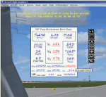
This gauge is specifically written for Captain Sim B707-300 and variants.
List of features: [New Items/Features]
Twenty-Two call-outs sounds integrated into gauge [15 new call-outs].
Take-off V-Speeds calculated for Flaps 14 with temperature and altitude adjustments.
[Take-off speed bugs automatically set for: V1, VR, V2].
[Flaps-up maneuvering speed (clean speed) bug set after flaps-up].
Optimum altitude and optimum EPR (EPR calc for M.80) are continually calculated.
Gross Weight overage will display in 'red' text. Tooltip indicates overweight value (LB/KG).
Take-off trim calculated for current gross weight.
Display units can be toggled between LB and KG (default LB).
Outside Air Temperature can be toggle between Fahrenheit and Celsius.
Resettable fuel use.
Resettable flight timer.
[Selectable Vref landing configurations, Vref40 (default) or Vref50].
[Approach / landing speed bugs automatically set for: Vref, Vref + 5, Vref + 10].
ZFW, Fuel, CG, Gross Weight and Barometric Pressure MSL (QNH) displayed.
['Barometer Set' call-out occurs when pressing keyboard letter 'B' (V-One gauge must be open)].
[Decision Height adjustment now on Data Card in hidden click-spot located on upper right corner].
[Now installation to a single location will work for all variants].
| Filename: | VOne_Gauge_for_Boeing_707300_Complete.zip |
| License: | Freeware, limited distribution |
| Added: | 3rd February 2013, 00:11:24 |
| Downloads: | 2,450 |
| Author: | Paul Tally |
| Size: | 3.14 MB |
| Category: Flight Simulator X - Gauges | |
| V-One Gauge for Captain Sim L-1011/F V1.3 |
|
File Description:
This is an updated V-One gauge for Captain Sim CS L1011 v1.3
The following changes are in this version release:
1. V-One code optimized to FSX xml.
2. Sounds are played using Captain Sim's sound module.
3. All voice recordings have been re-recorded.
4. Maneuvering speed display corrected to match L-1011 alpha control for flaps-up.
5. Sounds for call-outs call be toggled on-off.
6. Current trim displays Captain Sim's trim value (trim value does not match visual trim wheel).
7. Decision Height Set Knob (Captain's side) controls 'Minimums' call-out.
List of features: Approximately 40 sounds integrated into gauge. Take-off V-Speeds calculated for Flaps 10, 18 or 22. Take-off command speed automatically set for V2 + 15. Maneuvering speed displayed for flap selected. Optimum altitude and optimum EPR (EPR calc for M.84) continually calculated. Take-off trim calculated for current gross weight. Current Altitude, EPR, Speed (knts), Flaps and Trim displays via toggle. Display units can be toggled between LB and KG (default LB). Re-settable flight timer. Re-settable fuel use. Selectable Vref landing configurations, Vref33 (default) or Vref42. ZFW, Fuel, CG, Gross Weight and Barometric Pressure MSL (QNH) displayed.
| Filename: | VOne_Gauge_for_Captain_Sim_L1011F_V13.zip |
| License: | Freeware, limited distribution |
| Added: | 25th October 2015, 11:00:24 |
| Downloads: | 2,042 |
| Author: | Paul Tally, Stefan Liebe, Jimmy Foong |
| Size: | 3.93 MB |
| Category: Flight Simulator X - AFCAD Files | |
| Spitfire Aerodrome Airport (7N7), NJ |
|
File Description:
Located 02 miles S of Pedricktown, New Jersey on 48 acres of land, Spitfire Aerodrome Airport is a public asphalt single-strip field that allows transient craft to tie down on the apron. There are also helicopters based here on this field (note there is no Jet-A fuel available) so the helicopter start location will place you on the ramp.
Although this airport has a beacon, FSX for some reason does not include one with the stock airport file and I can't yet create rotating beacons so it is there and lit at night but does not rotate and is not as visible as the rotating ones. This will be addressed in a later update. Also take note of the layout of this airport, it requires that AI traffic cross the runway in order to taxi to either end for take off. AI aircraft DO NOT hold short when taxiing across runways (this is an FSX limitation), so use extreme caution on approach and departure to avoid any unfortunate runway incursions. Aircraft can fuel up by parking near the fuel truck beside the hangar south of the runway. If you have trouble locating the windsock, look on top of the hangar roof north of the runway. The crashed aircraft in the pond is fictional, there is a distinctive airplane-shaped object there in the satellite textures but I could not determine what this might be from aerial photos so I just crashed a plane there for kicks :)
Scenery constructed with use of satellite images/streetview/aerial photos - the author has not been there in person.
This scenery is meant to be used in conjunction with MegaScenery Earth New Jersey/Delaware 004. It is not required, but apron use is minimized to allow satellite scenery to show through as much as possible, and objects are placed based on the MSE textures - lack of it may make scenery look out of place.
| Filename: | Spitfire_Aerodrome_Airport_7N7_NJ.zip |
| License: | Freeware |
| Added: | 11th February 2011, 15:29:36 |
| Downloads: | 241 |
| Author: | Drew Sikora |
| Size: | 833.54 KB |
| Category: Flight Simulator X - Scenery | |
| YLGB Bidyadanga (La Grange Bay), Western Australia |
|
File Description:
YLGB Bidyadanga (La Grange Bay), the largest aboriginal community in WA has a population of 500 people and is situated 190km south of Broome. This is the traditional country of the Karajarri People who had their native title acknowledged by the Federal Court of Australia in 2003. Facilities in the community of Bidyadanga include a large community store, fuel outlet, multi-functional police unit, school, telecentre, and a community swimming pool completed in 2007. REQUIRES Blencowe_LibraryKit.zip
REQUIRES blencowe_librarykit_309494.zip (Available HERE)
| Filename: | YLGB_Bidyadanga_La_Grange_Bay_Western_Australia.zip |
| License: | Freeware |
| Added: | 28th February 2013, 13:55:11 |
| Downloads: | 221 |
| Author: | Alan Blencowe |
| Size: | 3.66 MB |
| Category: Miscellaneous Files - Miscellaneous Files | |
| McDonnell Douglas MD-80 Procedures Handsheet ** UPDATE ** |
|
File Description: This is a 6 page handsheet to be used on the great FS9/FSX addon Leonardo
Maddog McDonnell Douglas MD-80. While in the simulator, manuals and
tutorials are not very useful to read while flying, this procedures handsheet
will help you not to miss anything. It is based on several FCOM, LSH
documentations and several tutorials and real world cockpit videos founded on
the web. It is design to be used with the normal checklist provided with the
Leonardo Maddog.
V1.10 2013/03/14
Changes : added fuel heaters operation
| Filename: | McDonnell_Douglas_MD80_Procedures_Handsheet__UPDAT.zip |
| License: | Freeware |
| Added: | 14th March 2013, 14:29:26 |
| Downloads: | 906 |
| Author: | Kenz CHERIEF |
| Size: | 2.73 MB |
| Category: Flight Simulator X - AFCAD Files | |
| Albany Intl - KALB - New York |
|
File Description:
This airport was designed with the latest version of ADE (v1.47) and made only for the FSX default airport: one file with the Crosswind rwy operating, now activated by ADE where both rwy's will be used for takeoff/landing and one file as the default rwy operation: assigned parking with extra parking, extra fuel trucks, new control tower, taxiways and taxi signs updated including the lengthening of rwy 1/19, support vehicle roads rebuilt and many other improvements, airport views are from the roof of the control tower (when in tower view) please view the readme before installation
| Filename: | Albany_Intl__KALB__New_York.zip |
| License: | Freeware |
| Added: | 16th March 2010, 03:37:42 |
| Downloads: | 2,186 |
| Author: | Ray Smith |
| Size: | 31.28 KB |


© 2001-2026 AVSIM Online
All Rights Reserved
Privacy Policy |