
Where Flight Simulation Enthusiasts Gather from Around the World!
AVSIM Library - Search Results

| Category: Prepar3D V1-4 - Aircraft Repaints, Textures and Modifications | |
| North American T-6 Harvard (F-BJBF) |

|
Images related to this file:
File Description:
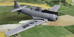
This folder contains a repaint for the A2A North American T-6 Texan/Harvard in the colors of North American T-6G F-BJBF, 1970. Originally built as 41-33931 (c/n 88-14948), it went to the RAF as EX959. It was used by the 20 Service Flying Training School in Rhodesia from January 1943 onwards. After the war, it was transported back to the UK, where it was sold to the Belgian Air Force, where it became H-9. It flew from Brustem until 1959. The Belgian Air Force then sold it to Air France, with 14 other Harvards, for use at its flight school in Pontoise Cormeilles en Vexin, west of Paris. It flew with Air France until 1965, when it was sold to Mr Urbain of Cannes, who flew it in bare metal with a checkered rudder until 1971. This is the paintscheme depicted here. It then went to the UK, becoming G-AZJD. It remained based at Biggin Hill until 1984, when it went back to France as F-AZDU, being bought by Guy Robert, a former Mirage pilot who recieved his training in the '50's on a Harvard in Marocco. In 2001 it was sold to John Colors SL in Barcelona, but it retained its French registration of F-AZDU. It is still airworthy, based at Sabadell in Spain. Repaint by Jan Kees Blom, based on the paintkit by A2A.
| Filename: | North_American_T6_Harvard_FBJBF.zip |
| License: | Freeware |
| Added: | 27th July 2020, 21:30:04 |
| Downloads: | 43 |
| Author: | Jan Kees Blom |
| Size: | 24.19 MB |
| Category: Flight Simulator X - Miscellaneous Files | |
| 737NG Normal Procedures Non-APU version |
|
Images related to this file:
File Description:
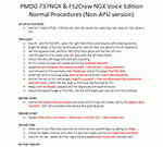
After some input and ideas from a fellow FS2Crew pilot here is a non-APU version of my flow and checklist to even closer mimic real world OPs the way many big airlines operate in real life every day at big airports around the world where the use of APU is limited to only a short period of time a couple of minutes before engine start. I also (don't I always ;-)) did some other changes and what I think improvements since my last version so give it a try and see what you think! About fitting the list on 2 A4 pages when printing it from WordPad please set all your margins to 25 mm in WordPad and uncheck the option to print the page numbers. This time I will not ask the AVSIM Library Managers to replace my old version with this one since some of you might still want the version where the APU is used depending on what kind of flights you do and to what kind of airports. Instead this will be uploaded as a new and separate version.
A flow/checklist for flying PMDG's 737NGX with FS2Crew Voice Edition. Did this mainly for my own use meaning the flow/checklist is adjusted for how I do my flying and with the addons I use like Aerosoft AES for example. Please also be aware this is not the kind of flow/checklist that includes all things you need to perform during a normal flight but instead you are expected to already have a general knowledge of both the NGX and FS2Crew. However I thought others might be helped by this too both newbies to get you going with the "flow" using FS2Crew but also for the more experienced users as a simple to print out and use memory note. It's also easy for you to change whatever you like to suit your own needs better since I created it in common rtf format using the standard Wordpad Windows application. I deliberately made it as compressed as possible leaving out stuff like all the answers to the checklists etc so it would fit on a single A4 sheet being easy to print and maybe also laminate if you like. Hope you'll enjoy it!
| Filename: | 737NG_Normal_Procedures_NonAPU_version.zip |
| License: | Freeware |
| Added: | 22nd June 2012, 03:34:37 |
| Downloads: | 1,085 |
| Author: | Richard Asberg (with input from Peter Wolf) |
| Size: | 6.36 KB |
| Category: Flight Simulator 2004 - Scenery | |
| Kotzebue PAOT on the northwestern coast of Alaska |
|
Images related to this file:
File Description:
There are four main northwestern Alaska towns which have good airports and are serviced by Alaska Airlines. From these airports local flights connect to nearby villages, "nearby" in Alaska meaning up to 150 miles away. The northernmost is Barrow. Southwest of Barrow is Kotzebue, then Nome, and the furthest south is Bethel. The town of Kotzbue is north of the Bering Strait on the northwestern coast, 320 miles southwest of Barrow. The population is just over 3,000 people. The location was for a long time a base for trading in furs, with three rivers emptying into the sea and providing routes into the interior land and villages; a meeting place between hunters and traders from Russia and elsewhere. The Kotzebue airport is called the Ralph Wien Memorial and has two runways. The modern one is aligned 08-26 and is 5,880 feet of 150 feet wide asphalt built across a shallow lagoon, with an ILS on 08 and PAPI on both ends. The second and older runway is originally military and gravel, aligned 17-35 and 3,786 feet long and used (wind allowing) by the GA planes that park alongside the runway. The prevalent wind is from the west; when the wind is from the east it is generally relatively feeble and with a much lower cloud base, possibly to the ground, hence the need for an ILS. All AI aircraft in FS9 much prefer to use a runway that has an ILS and so will continue to use 08-26 even if the wind is from the south until it reaches 30+ knots, even if they are a Cessna 150 flying VFR. So for AI realism in FS9 a northern or southern wind needs to be a strong one so that the runway is actually used. However, as Alaska Airlines, Northern Air Cargo, and Everts Air also fly to Kotzebue and can only use the east-west runway (as less than 4,000 feet of asphalt would be seriously inconvenient for a Boing 737 or DC6) it is necessary to have the northern or southern wind UNDER 30 knots at the times when they are landing or taking off. Your choice. I suppose a permanent strong wind from the west would be the most realistic on a daily basis, deterring all planes from ever using 17-35. The AI will develop along with further scenery additions in the neighbourhood.
| Filename: | Kotzebue_PAOT_on_the_northwestern_coast_of_Alaska.zip |
| License: | Freeware, limited distribution |
| Added: | 2nd August 2016, 16:47:52 |
| Downloads: | 463 |
| Author: | Roger Wensley |
| Size: | 19.32 MB |
| Category: Flight Simulator 2004 - Scenery | |
| Nome PAOM on the northwestern coast of Alaska |
|
Images related to this file:
File Description:
There are four main northwestern Alaska towns which have good airports and are serviced by Alaska Airlines. From these airports local flights connect to nearby villages, "nearby" in Alaska meaning up to 200 miles away. The northernmost is Barrow. Southwest of Barrow is Kotzebue, then Nome, and the furthest south is Bethel. The town of Nome is south of the Bering Strait on the southern coast of the Seward Peninsula, around 185 miles south of Kotzebue, with a population of about 3,800. It is the town that led to the creation of the most famous dogsledge race in the world, the Iditarod, which is based on the delivery to Nome of diphtheria serum during the blizzard conditions of the winter of 1925. The Nome airport (it currently has no other name) was originally built as the last of the refuelling airfields for planes being ferried to Russia during WW2. It has two runways, aligned 09-27 and 02-20 in FS9 (the wandering magnetic north has recently renamed the magnetic headings) and both of them around 6,000 feet with an ILS on 27. There is a modern airport layout diagram included showing taxiway names etc. Alaska Airlines, ERA, and Bering Air (which is headquartered in Nome), along with the shared cargo terminal for Northern Air Cargo and Everts Air, are all on the southern apron. The northern apron is mainly for GA, along with maintenance facilities, a garage building that also houses a weather bureau, and at the far northern end of runway 02-20 an apron and hanger for the Alaska Air National Guard. All AI aircraft in FS9 much prefer to use a runway that has an ILS and so will continue to use 09-27 even if the wind is from the north or south, right up until it reaches 30+ knots, so for AI realism in FS9 a permanent wind from the west would be the most realistic on a daily basis. There is also a small gravel strip just north of the town and this is included (94Z), as are some old line-of-sight radio communication reflectors on the hills above the town. There is a note about making adjustments to Ultimate Terrain Alaska-Canada regarding both realistic road lighting and also auto-generation.
| Filename: | Nome_PAOM_on_the_northwestern_coast_of_Alaska.zip |
| License: | Freeware, limited distribution |
| Added: | 18th October 2016, 02:38:42 |
| Downloads: | 489 |
| Author: | Roger Wensley |
| Size: | 22.65 MB |
| Category: Flight Simulator 2004 - Scenery | |
| North Haledon Lite |
|
File Description:
This is Chopper Friendly scenery, folks. It wasn't designed to be flown over at 10,000 feet - although, if you like to fly heavy iron into the major New York/New Jersey airports, you'll notice that it replaces the terrain elevation of Northern New Jersey with all the hills and valleys that the default scenery left out. No, this is interactive scenery. Built to be explored low and slow.
Want to perfect your landing skills in a huge playground of rooftops, irregular terrain, and tight spaces? This is the place. You won't find any unlandable surfaces or false crashes here - just hundreds of places to touch down ranging from beginner, through expert, to downright sick!
This is the lite version, designed for people who are having trouble with the frame rates of the full version. I've thinned out the houses and trees, and removed the buildings South of Oldham Pond - but managed to keep most of the interesting places to land. In the tests I've done, there was about a 20 percent frame rate increase on average compared to the full version, with nearly a 45 percent increase in the most framerate-hostile areas.
| Filename: | North_Haledon_Lite.zip |
| License: | Freeware, limited distribution |
| Added: | 1st June 2006, 04:48:01 |
| Downloads: | 656 |
| Author: | Mick Posch |
| Size: | 11.38 MB |
| Category: Flight Simulator X - AFCAD Files | |
| Active ILS - KATL (Hartsfield - Jackson Atlanta Intl Airport) |
|
File Description:
Many know that KATL was not updated in FSX do to the airport data cutoff date. KATL now has the new Runway 10/28 but there are many additions added which are to numerous for listing here. Several key changes are all 5 parallel runways are ATC controlled Arrival runways for both the User and AI Plane Traffic. All Gates and Parking Spots have been updated so AI Airline Planes including Cargo, Commuter, and Corporate GA park in the correct places. New Approach code including the 5 new STAR's, RNAV (gps overlay's), many new Transitions and correct Runway data as per current Jeppesen Charts (freeware charts included). Many features have also been fixed such as Jetways that moved the wrong way, recoding the ILS CAT II Runway 28 frequency, updating KLZU ILS Runway 25 frequency, many scenery GUID's to support KATL based on how it looks today and additional ground support tracks that go to many more places including all Cargo Stands. Read the included Whats New Readme txt file for all the enhancements and how I coded ATC to use all 5 parallel runways for arrival vectors to decrease the go around issues at large airports.
| Filename: | Active_ILS__KATL_Hartsfield__Jackson_Atlanta_Intl_.zip |
| License: | Freeware, limited distribution |
| Added: | 1st January 2007, 22:57:34 |
| Downloads: | 30,380 |
| Author: | Jim Vile |
| Size: | 10.84 MB |
| Category: Flight Simulator 2004 - Sounds | |
| ATC Voices -Airport names set 12 |
|
File Description:
A collection of 29 additional or corrected airport names, for use with
Flight Simulator 2004 and FS2002. Installation requires the
EditVoicepack software (see
http://bevelstone.xs4all.nl/FlightSimulator/EditVoicepack) by Lars
Møllebjerg which is also available as a free download from the usual Flight
Simulator download sites such as Avsim.
The airports represented here are:
3EO: Miami-Roberts Co (United States of America),
3TE5: Panhandle/Stamps Field (United States of America),
51K: Cedar (United States of America),
E26: Jal/Lea Co (United States of America),
EFET: Enontekio (Finland),
ENKJ: Lillestrøm/Kjeller (Norway),
ENY2: Setermoen (Norway),
ESDA: Ljungbyhed AB (Sweden),
ESUK: Kalixfors (Sweden),
FZRQ: Kongolo (Congo DRC),
LERM: Robledillo De Mohernando (Spain),
LFOI: Abbeville (France),
LILG: Vergiate (Italy),
LSPM: Ambri (Switzerland),
MYAP: Spring Point (Bahamas),
MYX4: Big Whale Cay (Bahamas),
O45: Hooker Muni (United States of America),
OEUM: Umm Lejj (Saudi Arabia),
OIIE: Ika (Iran),
PANGALPINANG: Pangkalpinang (Indonesia),
SN58: Foster Field (United States of America),
SWEI: Eirunepe (Brazil),
T45: Panhandle-Carson Co (United States of America),
UBBN: Nakhichevan (Azerbaijan),
WAOI: Iskandar (Indonesia),
WBGT: Long Banga/Tanjung Manis (Malaysia),
WIKD: Tanjung Pandan/H.A.S. Hanandjoeddin (Indonesia),
WIPK: Depati Amir (Indonesia), and
YBVA: Balaklava (Australia).
| Filename: | ATC_Voices_Airport_names_set_12.zip |
| License: | Freeware |
| Added: | 27th November 2007, 14:15:16 |
| Downloads: | 2,252 |
| Author: | John Hinson |
| Size: | 21.05 KB |
| Category: Flight Simulator X - Missions | |
| Flight to Area 61 |
|
File Description:
Captain Igor Kringbrinsky of the "Special Air Service" will be piloting flight XX-C4 to " Special Area-61"
better known to pilots as " No-whereland".
As usual he is being moved to the base at the Ust-Kamenogorsk Airport (UASK) three days before the
flight. Using an old ANT-2 he will carry electronic supplies(????) and will also pickup on the way to the
different locations (To be known only before the flight) special personnel that work in these places and
who are coming out for vacations.
As co-pilot you will have to check the plane before the flight and since on this flight you are to be rated,
previous to becoming pilot-in-command for future flights, you will do all take offs and landings.---Carefully
study the maps given to you for the " secret" locations you will land before you reach Area 61.
These "locations" may be on "Roadways", mountains, valleys and even large airports-----
Sorry to say, the Weather this time of the year is "stormy and rain, thunder and high winds may be
expected....This is a hard Mission.
| Filename: | Flight_to_Area_61.zip |
| License: | Freeware, limited distribution |
| Added: | 21st April 2008, 09:42:55 |
| Downloads: | 2,855 |
| Author: | Gera Godoy Canova |
| Size: | 5.93 MB |
| Category: Flight Simulator 2004 - Sounds | |
| ATC Voices -Airport names set 14 |
|
File Description:
A collection of 34 additional, improved or corrected airport names, for
use with Flight Simulator 2004 and FS2002. Installation requires the
EditVoicepack software (see
http://bevelstone.xs4all.nl/FlightSimulator/EditVoicepack) by Lars
Møllebjerg which is also available as a free download from the usual
Flight Simulator download sites such as Avsim.
The airports represented here are:
CYC: Caye Chapel (Belize),
EG58: Little Staughton (United Kingdom),
EG83: Eshott (United Kingdom),
FLJK: Lower Zambezi Reserve/Jeki (Zambia),
FLMO: Monze (Zambia),
HBBO: Kirundo (Burundi),
HE1B: Bilbays (Egypt),
HLFL: Bu Attifel (Libya),
HLML: Bilbays (Egypt),
HRYU: Ruhengeri (Rwanda),
LFDP: St Pierre d'Oleron (France),
LFDV: Couhe (France),
MHIC: Islas Del Cisne (Honduras),
MMJA: Jalapa (Mexico),
MP0H: Punta Cocos (Panama),
MYCB: New Bight (Bahamas),
MYMM: Mayaguana (Bahamas),
MZ03: Maya Beach (Belize),
SBCJ: Parauapebas/Carajas (Brazil),
THORNHILL FINAL and THORNHILL PATTERN: Gweru/Thornhill AB (Zimbabwe)
UKCV: Mariupol (Ukraine),
UKDB: Berdyansk (Ukraine),
UT0M: Maymanak (Uzbekistan),
UT0U: Navoi (Uzbekistan),
UTSK: Karshi Khanabad (Uzbekistan),
WAAU and WAWW : Kendari/Wolter Monginsidi di Kendari (Indonesia) - old and new codes,
WBGP: Kapit (Malaysia),
WRLR: Tarakan (Indonesia),
WRLT: Tanjung Santan (Indonesia),
YALG: Adels Grove (Australia),
YCIG: Corrigin (Australia), and
YKLN: Kulin (Australia).
| Filename: | ATC_Voices_Airport_names_set_14.zip |
| License: | Freeware |
| Added: | 16th May 2008, 11:24:14 |
| Downloads: | 1,650 |
| Author: | John Hinson |
| Size: | 24.62 KB |
| Category: Flight Simulator 2004 - Scenery | |
| MYER Rock Sound International, Eleuthera Island, Bahamas |
|
File Description:
Googly scenery for Rock Sound International (ICAO: MYER), a grand-sounding but
quiet airport located on Eleuthera Island, Bahamas. Eleuthera is a long
and thin island east of Nassau and has three commercial airports, the busiest
being Governor's Harbour. Rock Sound is at the southern end and is served twice
daily by Dash 8 turboprops of Bahamasair, along with occasional flights by
operators such as Southern Air Charter. The airport has seen busier days and
was once even served from Europe by Alitalia.
Microsoft have only provided general aviation facilities at this airport in
Flight Simulator 2004 and this scenery seeks to redress the situation
so that you and your "AI" traffic can use the airport realistically.
The scenery does not purport to be ultra-accurate. Based on high quality
satellite imagery from Google Earth, the layout is proportionally correct but the
added airport features, such as buildings, are built from default Microsoft objects
and add-on libraries so will not look exactly like the real thing.
You are not obliged to download and install any additional scenery libraries,
but to enjoy this scenery in its entirety, you may wish to. It will work fine,
with or without.
| Filename: | MYER_Rock_Sound_International_Eleuthera_Island_Bah.zip |
| License: | Freeware |
| Added: | 13th October 2008, 11:01:56 |
| Downloads: | 1,468 |
| Author: | John Hinson |
| Size: | 61.42 KB |


© 2001-2026 AVSIM Online
All Rights Reserved
Privacy Policy |