
Where Flight Simulation Enthusiasts Gather from Around the World!
AVSIM Library - Search Results

| Category: Flight Simulator 2004 - Miscellaneous Files | |
| Active ILS - KMCO (Orlando International Airport) |

|
File Description:
This is the 3rd Airport in a series of new ILS runways. As most know initiating the ILS at certain airports for AI Traffic is not a function at this time when using AFCAD2. If you add a new ILS runway to an airport such as KMCO (Orlando International Airport 17L/35R) only the user aircraft can use this runway when visibility falls below 3 miles. ATC will no longer use this runway for AI Traffic because FS9 sees it as a visual runway. This will cause ATC to vector your AI Traffic back to 17/35 (old numbers) 17R/35L (new numbers) which is also a Terminal departure runway. This file adds all NAVAIDS for making 17L/35R a Precision Instrument Runway. I have added all the radar fixes for both the ILS approach portion and the proper missed approach procedures, altitudes and intersections as per current published plates. All AI Aircraft will now continue to use 17L/35R when Airport visual conditions are less than 3 miles.
| Filename: | Active_ILS__KMCO_Orlando_International_Airport.zip |
| License: | Freeware, limited distribution |
| Added: | 25th June 2004, 01:50:15 |
| Downloads: | 3,846 |
| Author: | Jim Vile |
| Size: | 45.38 KB |
| Category: Flight Simulator 2004 - Miscellaneous Files | |
| Active ILS - KIAH v2.0 |
|
File Description:
UPDATED KIAH see the readme file -- By design KIAH is now another Airport that features advanced ATC control. As most know initiating the ILS at certain airports for AI Traffic is not a function at this time when using AFCAD2. If you add a new ILS runway to an airport such as KIAH (8L/26R) only the user aircraft can use this runway when visibility falls below 3 miles. ATC will no longer use this runway for AI Traffic because FS9 sees it as a visual runway. This will cause ATC to vector your AI Traffic back to 8/26 (old numbers) 8R/26L (new numbers) which is also a Terminal Departure Runway. All 5 runways for KIAH are now simultaneously active for departure and arrival. There are many additional options added to version 2.0 so follow the instructions in the README and just sit back (or fly) and plane spot either VMC or IMC for a very active airport. *** SimFlyers Scenery AFCAD2 and special ILS bgl also included ***
| Filename: | Active_ILS__KIAH_v20.zip |
| License: | Freeware, limited distribution |
| Added: | 26th August 2004, 02:23:19 |
| Downloads: | 2,720 |
| Author: | Jim Vile |
| Size: | 81.21 KB |
| Category: Flight Simulator 2004 - AFCAD Files | |
| LPPT by PPP, and EDDH |
|
File Description:
AFCAD2 File for :
Lisbon, Portela Intl Airport, Portugal ( LPPT )
for PPP Scenery of Portugals's LPPT, LPPR and LPFR airports.
Although Runway 17/35 is rarely used, I have decided to open it for Take-off and landing .
Primarily 21 and secundary 35 ( Can't make 3 and 17 work, though I haven't tested it with wind.
Can be found on Avsim as ppp30.zip ( PPP version 3.0 )
All credits to the PPP team for LPPT/LPPR/LPFR sceneries, many many thanks .
( Not to bo used with the default scenery )
You may have to delete Airport.bgl in the scenery file of PPP, otherwise this Afcad file will not work .
For that reason also back-up Afcad files for PPP's LPPR and LPFR included.
Also included Hamburg, Fuhlsbuttel airport, Germany ( EDDH ) for Jan Martin's
jtacof_4.zip ( Jetways & Terminals For ACOF Package Four ) ( can also be used with default scenery )
Primarily Runway 15 and secundary 05 ( again I am not sure if 33 and 23 work , haven't tested
it with wind .
Tested them in my own FS2004, and it works well .
Have fun!
| Filename: | LPPT_by_PPP_and_EDDH.zip |
| License: | Freeware |
| Added: | 10th October 2004, 03:42:57 |
| Downloads: | 1,640 |
| Author: | Silvester van Wijk |
| Size: | 26.7 KB |
| Category: Miscellaneous Files - General Utilities | |
| Flight Creator Version 0.6 |
|
File Description:
Flight Creator 06 is much updated from the previous version (0.2) released on AVSIM. This version has over 22,000 airport locations world-wide included and the user can set up operational areas anywhere using a range or criteria, or select specific airports to be included. The user can also create their own locations. FC 06 handles different types aircraft which can be selected by the user. The type of flight and loads to fly depend on the aircraft selected. Full random criteria can be used or specific selections made. The flying time of each leg can be limited, and the user can decide whether to use real weather or the simple weather generator included in the program. Aircraft and cargo & passenger loads are stored in separate files and the user can create their own (using Notepad in this version).
This is still a work in progress and the future development list is included in the documentation. The author is happy to recieve suggestions for improvements and future functionality. FC 06 is simulator independent.
| Filename: | Flight_Creator_Version_06.zip |
| License: | Freeware, limited distribution |
| Added: | 27th December 2003, 19:38:55 |
| Downloads: | 1,945 |
| Author: | Jon Masterson |
| Size: | 690.25 KB |
| Category: Flight Simulator 2004 - Scenery | |
| Kona at Keahole International Airport PHKO |
|
File Description:
This is a completely new Kona, which is now more correctly laid out and very detailed. This is one of the most unique and beautiful airports in the world. It resembles a Hawaiian Village and Botanic garden combined, and is completey open air. The airport is built on old lava flows, and the terminal area is full of lava rock walls, which was probably mined while constructing the taxiways, tarmacs, and terminal itself. This scenery redoes the entire airport, and includes details like baggage carrousels, benches at the gate areas, check-in counters, parking lot shelters, and some purple baggage carts to go with the Island atmosphere. Since this airport has no jetways, I have created some new lower impact air stairs, and have positioned them around the two main gate areas. There is also a large air stair at each gate area to accommodate heavy jetliners. The unique ramp lights found at this airport are also included as well as some interesting night lit ramp textures. It has not been tested in FS2002.
| Filename: | Kona_at_Keahole_International_Airport______PHKO.zip |
| License: | Freeware |
| Added: | 16th January 2004, 14:14:35 |
| Downloads: | 6,781 |
| Author: | Bill Melichar |
| Size: | 5.52 MB |
| Category: Flight Simulator 2002 - Original Aircraft | |
| Douglas DC-3 Val-U-Prop CargoLiner Plane and Panel |
|
File Description:
Val-U-Prop is a rogue airline based in Bloomington, Indiana, that flies everything from VIPs to sheep manure anyplace and anytime. VP's motto is "No job too small; No fee too large," and our DC-3's, DC-4's, DC-6's and DC-8's can be seen hedge-hopping into various obscure airports throughout the world. This aircraft is an all-aluminum re-paint of the fabulous DC-3 OH-LCH by Jan Visser, Erik Ellis, Roy Chaffin, Ian Roper and Bill Rambow, to which FS2002 lights have been added. It has military capability, including machine guns and NUCLEAR/GPS/JDAM guided bomb launch. Panel includes everything on main panel, except for GPS and (optional) default radios, so there is no tabbing. The very aluminal wing views were shot by Thomas Klein, and the vintage C-47 cabin was photographed by Tom Turner. Gauges by James Underwood, Ernie Kennedy and Dai Griffiths. A-bomb and machine guns by Chris Trotter. All of this brought to you by Val-U-Prop - http://home.bluemarble.net/~jcumus/index.html - where WE VAL-U-YOU!
| Filename: | Douglas_DC3_ValUProp_CargoLiner_Plane_and_Panel.zip |
| License: | Freeware, limited distribution |
| Added: | 11th March 2003, 02:19:37 |
| Downloads: | 2,594 |
| Author: | James Underwood |
| Size: | 6.64 MB |
| Category: Prepar3D V1-4 - Scenery | |
| Valdez Alaska USA N61.06.53 W146.19.52 and Tatitlek Alaska USA N6052.00 W146.41.37 |
|
File Description:
Valdez Alaska USA N61.06.53 W146.19.52 The town is positioned at the head of a fjord on the eastern side of the Prince William Strait (at the end of the Valdez bay). It is surrounded by the Chugach mountains with many glaciers and peaks up to 2100 m above sea level. Although the northernmost port in North America is free of ice all year round. It is also the northernmost point of the Pacific coastal forest located in the 107-meter hill southwest of the town called Blueberry Hill. Valdez has an ICAO PAVD airport that in the scenario in addition to the city of Valdez you will also find a small village called Tatitlek Alaska USA N6052.00 W146.41.37 with related ICAO 7KA airport airports infrastructures have been improved with the addition of a port for landing ships and seaplanes on Valdez and Tatitlek. Important VFR point for approaching airport and seairport PAVD and 7KA.
Within the downloaded package you will find readme files for scenery installation. Good fly VFR. Pasquale Marrulli.
| Filename: | Valdez_Alaska_USA_N610653_W1461952_and_Tatitlek_Al.zip |
| License: | Freeware |
| Added: | 21st May 2018, 22:35:56 |
| Downloads: | 231 |
| Author: | Pasquale Marrulli |
| Size: | 3.27 MB |
| Category: Flight Simulator X - Utilities | |
| FSX/P3D Quick ILS Utility Ver 3.1.5 **UPDATE ** |
|
Images related to this file:
File Description:
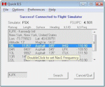
This utility was written to simplify the process of finding the ILS frequency when ATC assigns an ILS approach. Operation is simple. Enter the ICAO, click the Search button and a list of all runways, runway lengths and runway ILS frequencies for that ICAO are displayed. Here's the quick part... Just double click on a runway and the ILS frequency will instantly be set in the Nav1 radio. You can also start Flight Simulator, load a flightplan and then start Quick ILS. It will automatically read the flightplan and then display the destination airport's runway data. Again, just double click on the assigned runway to set the Nav1 radio for the ILS approach. ILS data aside, General Aviation fans may want to use Quick ILS to get information about possible destination airports. Enter an ICAO and you can quickly view the runways available, their length, the surface (ie grass, gravel, paved...) and the runway headings. Version 3.1.5 adds the ILS ID to the display. Freeware by Dave Westbury.
| Filename: | FSXP3D_Quick_ILS_Utility_Ver_315_UPDATE_.zip |
| License: | Freeware |
| Added: | 12th August 2014, 10:25:51 |
| Downloads: | 3,581 |
| Author: | Dave Westbury |
| Size: | 457.35 KB |
| Category: Flight Simulator X - Miscellaneous Files | |
| State Capitals.zip |
|
File Description:
I have been using BAsys excellent Visit series in free flight and collected a large number.
But the USA just has too many airports for my lifetime.
Therefor I have created a set or rewards for state capitals and Washington DC.
Comprise a seal with the flag as detail for each state and one for the complete collection 52 in all.
I automated the creation of xml files, GUID generation etc by creating macros for excel 2007 and up.
create your XML file add the two images small and large and drag to BGLcomp.exe
and your reward is created.
Incidently the original fsx 2009 sizes of 100x80 and 300x370 is no longer a restriction that is found in old reward compilers. I use 100x100 for the small and upto nnnx370 for detail. nnn=upto 680
You can therefore use real holiday photos id you wish.
The folder that does this is also included in the attached State Capitals.zip
Unzip drop the folder US States into ..\fsx|rewards and start flying.
| Filename: | State_Capitalszip.zip |
| License: | Freeware |
| Added: | 25th February 2017, 07:17:58 |
| Downloads: | 139 |
| Author: | Brian Bean |
| Size: | 3.63 MB |
| Category: Flight Simulator 2004 - Aircraft Repaints, Textures and Modifications | |
| KLM Boeing 737-7K2 WL (PH-BGR) |
|
Images related to this file:
File Description:

Koninklijke Luchtvaart Maatschappij N.V. (KLM Royal Dutch Airlines), known by its initials KLM, is the flag carrier airline of the Netherlands. KLM's headquarters is in Amstelveen near its hub at Amsterdam Airport Schiphol. KLM operates worldwide scheduled passenger and cargo services to more than 90 destinations. It is the oldest airline in the world still operating under its original name. The merger of KLM with Air France in May 2004 created Air France-KLM, which is incorporated under French law with headquarters at Paris-Charles de Gaulle Airport. Both Air France and KLM continue to fly under their distinct brand names. Air France-KLM is part of the SkyTeam alliance.
KLM's livery is painted on TDS's Boeing 737-700 model (included). The textures are saved in 32bit format for quality graphics. Textures are also characterized by HD (High Definition). Its features are idle-reverser animation, animated pack vents and pressurisation outflow valve, detailed textures, accurate paint, dynamic shine & effects, dynamic flexing wings that respond to turbulence, fully independent suspension, trim animation, gear steering, accurate flight dynamics, spoiler animation, reflective cockpit windows, improved wingflex code with input from several new parameters including ground spoilers, fuel load, and angle of attack, transparent navigation light lenses and many more. Visit my facebook page "Aviation Art Paintings by Giacomo Tomasini" for news, updates and previews on my future repaint projects: https://www.facebook.com/AviationArtPaintings . Thanks for downloading & Happy flying.
| Filename: | KLM_Boeing_7377K2_WL_PHBGR.zip |
| License: | Freeware |
| Added: | 20th September 2013, 21:40:59 |
| Downloads: | 1,119 |
| Author: | Giacomo Tomasini / Tenkuu Developers Studio (TDS) |
| Size: | 13.53 MB |


© 2001-2026 AVSIM Online
All Rights Reserved
Privacy Policy |