
Where Flight Simulation Enthusiasts Gather from Around the World!
AVSIM Library - Search Results

| Category: Flight Simulator X - Scenery | |
| North Victoria v2 for ORBX v2 YBLA Benalla YECH Echuca YYWG Yarrawonga |

|
Images related to this file:
File Description:
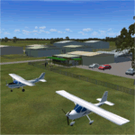
'North Victoria v2' is made to match ORBX Australia v2 scenery. Use 'YBLA Benalla' 'YECH Echuca' 'YYWG Yarrawonga' for ORBX v1 or no ORBX. There are 3 airports YBLA Benalla YECH Echuca YYWG Yarrawonga. ORBX has done these as they have done every airport included with FSX in Australia to a reasonable standard. If I had not already done them for ORBX V1 I would not have bothered. However these are better than ORBX because the surroundings have been modified to match real life. Towns have been added or shifted. Forests cut down or added. There are also custom accurate versions of the actual terminal buildings/hangers. In short a lot more time spent. ORBX had to do every airport has in Australia! Orbx have AI traffic files that cover all 3 airports. These files are for Flight Simulator X. Made using Airport Design Editor using some objects borrowed from Robert Budd's excellent Baccus Marsh and 'Static aircrafts' by Jean-Pierre Fillion. REQUIRED The scenery is designed to interface with ORBX FTX_AU V2 scenery for Australia (payware).
| Filename: | North_Victoria_v2_for_ORBX_v2___YBLA_Benalla_YECH_.zip |
| License: | Freeware |
| Added: | 2nd November 2019, 18:57:53 |
| Downloads: | 325 |
| Author: | Colin Jeffery |
| Size: | 10.01 MB |
| Category: Flight Simulator X - Utilities | |
| AI Cull Traffic Density Tool for FSX/P3D (Version 1.1) |
|
Images related to this file:
File Description:

The AICull.exe utility provides intelligent traffic density for AI aircraft. The user enters the ICAO(s) of the airports the user (typically) departs from and arrives at. AICull then removes AI that is not departing from or arriving at these ICAO(s) in order to boost frame rate, but still maintain an immersive AI experience for the user. That is, the user will perceive normal traffic density at the airports the user departs or arrives at, however all other AI in the area will be deleted saving frame rates and memory. The user may also enter an unlimited number of ICAO(s) to monitor. The user may also update the list of ICAO(s) while the program is running. AICull.exe requires SimConnect and the latest, registered version of FSUIPC ver. 4.9x (or later version). For best results, use with traditional bgl-based AI traffic (e.g., default, Word of AI, My Traffic X, etc.) although the program does work to lesser effect with the simconnect-based Ultimate Traffic 2 (see the included ReadMe). Revision: fixed "Problem Opening FSUIPC Link" for P3D.
| Filename: | AI_Cull_Traffic_Density_Tool_for_FSXP3D_Version_11.zip |
| License: | Freeware |
| Added: | 22nd March 2014, 00:16:44 |
| Downloads: | 3,122 |
| Author: | Roland Foster |
| Size: | 306.83 KB |
| Category: Flight Simulator 2004 - Miscellaneous Files | |
| Some Curved or Angled Approaches, Beirut, Washington Reagan, Lugano and Swiss valleys |
|
File Description:
This little project started from my Air Glaciers package when I noticed how indifferent the AI pilots were to terrain. Intrigued by the work of Jim Vile on his "active approach" series I have experimented with interesting approaches that FS9 has not implemented. Using XML files I created curved approaches for Beirut Runway 21 ILS (inbound flights arc across the city), the visual turn to final for Washington Reagan's Runway 19, the circling approach for runway 19 at Lugano in Switzerland (just an arc in this case) and valley approaches for airports in Switzerland at Sion, Samedan and Locarno. Due to AI limitations in FS9 these have all needed to be created as ILS approaches, even at airports without an ILS. Note that your AFCAD layouts do not need to have ILS added to airports that don't have it. In some cases the approach will be called an ILS by the controller, if you can live with that, you might like these. Note that I've included the source XML for each of the approaches so that you can improve upon them if you wish. Note also that they have been tested with the default Microsoft mesh and an addon mesh might alter the proximity of terrain to aircraft. AI aircraft FDEs will, in some cases, be stretched to (and beyond?) their limits. In the case of Beirut I have included two approaches (BOB NDB and "Wide Arc"), the latter less demanding than the former, in case your AI can't fly the BOD NDB approach.
Note that although the approaches are designed for AI, I have built full procedures for Lugano and Sion for the user to fly.
| Filename: | Some_Curved_or_Angled_Approaches_Beirut_Washington.zip |
| License: | Freeware, limited distribution |
| Added: | 8th April 2005, 03:19:33 |
| Downloads: | 2,760 |
| Author: | Matthew Ministry |
| Size: | 478.08 KB |
| Category: Flight Simulator 2004 - Gauges | |
| FS2004 GPS Map View Gauge v3.0 |
|
File Description:
The ultimate gauge. The Map will show: Airports details (Runways ID's, length & ILS), VOR's and NDB's frequencies,
Intersections and waypoints, Airspaces, Approaches and flight routes. You can toggle the view
you require for your flight. Also you can zoom in/out to see the nearest airports, vor's and
ndb's. The map will indicate A/C heading flightplan title and waypoints ID's.
Version 3 includes more enhancements such as the ability to input the ICAO code or name of any airport and the map will
show all the frequencies of that airport including ATIS, ILS, AND COM. In addition, the map will show the active
runway designations, length and width.
You can also input ICAO code of any VOR/NDB and the map will show their frequencies.
There was a bug in v2.0, in which if you enter ( click on ENT )the ICAO code of an airport, you will lose the flight
plan loaded. Now you can go back to the flight plan and with the NEXT/PREV buttons you have the choice of where to start
your FP.
The gauge will show Flight Plan Title, originating and destination airports, active waypoint, waypoint index and FP
crusing altitude.
I addition, the gauge will show various useful information, such as, Runway IDs, lenght, width and approach magnetic heading,
Airport name, city, and type. NAV1/2 names, codes, distances and ETA's, ADF1/2 names and codes.
Finally, the gaugee will show other information, such as, magvar, indicated airspeed, mach, ground velocity, ambient
wind velocity and direction, bank angle , and a/c altitude ( radio height ).
All the information above and much more on a single gauge window.
| Filename: | FS2004_GPS_Map_View_Gauge_v30.zip |
| License: | Freeware, limited distribution |
| Added: | 14th September 2005, 14:19:46 |
| Downloads: | 10,837 |
| Author: | Talal Alhaj |
| Size: | 710.05 KB |
| Category: Microsoft Flight Simulator (2020) - Aircraft Repaints, Textures and Modifications | |
| Bleriot XI F-AZPG |
|
Images related to this file:
File Description:
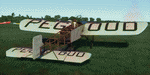
This folder contains a repaint for the Bleriot XI by Wings42 in the colors of Bleriot XI-2 F-AZPG, a replica Bleriot XI, based with the Amicale Jean-Baptiste Salis in La Ferte Alias in France. Adolphe Pégoud, whose name is on the wings, was a French pilot and flight instructor who became the first fighter ace in WW1. He was the first pilot to make a parachute jump from an airplane, and was the second pilot to fly a loop. He died when he was shot down by one of his prewar German students on 31 August 1915 at the age of 26. Repaint by Jan Kees Blom
| Filename: | Bleriot_XI_FAZPG.zip |
| License: | Freeware |
| Added: | 8th May 2021, 17:40:05 |
| Downloads: | 12 |
| Author: | Jan Kees Blom |
| Size: | 39.81 MB |
| Category: Flight Simulator 2004 - Scenery | |
| KJIF Jacksonville Imeson Airport Retro scenery |
|
File Description:
*** This is an updated version with fixes and instructions for locating some of the ai aircraft needed.***
Imeson Field, as it was also known, has been long closed down and replaced by the Jacksonville International airport (KJAX) in 1968. This scenery will bring back Imeson Field (and remove KJAX) to its glory days of the 1950s and 1960s with traffic files to match. Dan French has provided custom terminals, hangars and buildings for this project and Deltadart has provided many custom Military aircraft textures covering the many aircraft types employeed by the 159th FIS Forida Air National Guard during this period. This scenery is meant to work with the Calclassic retro environment by Tom Gibson and the Calclassic community.
| Filename: | KJIF_Jacksonville_Imeson_Airport_Retro_scenery.zip |
| License: | Freeware |
| Added: | 9th April 2023, 18:56:18 |
| Downloads: | 78 |
| Author: | Al Von Pingel |
| Size: | 22.44 MB |
| Category: Flight Simulator X - Scenery | |
| Vietnam War project - base pack |
|
Images related to this file:
File Description:
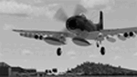
FSX Vietnam War Project - base pack version 0.9. FSX SP1/SP2 needed - Acceleration Pack optionnal, recommended.
About 100 new and redone airfields from SEA (Cam Ranh, Bien Hoa, Phu Cat, Nakhon Phanom, Korat...). French and English documentation (50 pages). Requires Vietnam War project AI airplanes (VnW_AI.zip).
TAD for each airfield. Additional sceneries. 25 flight plans to help you flying over the area.
Included : Al Simms Vietnam war objects, Jim Dhaenens Radars, lights and shelters, Guy Diotte static airplanes.
2 Objects libraries needed : read the quick installation guide.
Visit the project web site : http://vietnamwar.project.free.fr/
To contact us : [email protected]
FSX Vietnam War project: Jacques Godfrin - Xavier Carre
| Filename: | Vietnam_War_project__base_pack.zip |
| License: | Freeware, limited distribution |
| Added: | 11th April 2010, 07:57:17 |
| Downloads: | 2,045 |
| Author: | Jacques Godfrin, Xavier Carre, Vietnam War project |
| Size: | 76.47 MB |
| Category: Flight Simulator 2004 - AI Flight Plans | |
| XL Airways France, Winter 2010-2011 |
|
Images related to this file:
File Description:

"XL Airways France" is a French charter and regular airline, carrying out flights for tour operators to and from France, to Europe, the Maghreb, West Africa, Caribbeans, South and North America. It has a fleet of two A330-200, three A320-200, and a B737-800w. To ensure all these many flights this winter, the company has leased an A330-200 from Air Transat, one A330-300 as well as the colours of "Iberworld" with Orbest. All flights operated by the company, the second fortnight of December, were modeled here.
THIS IS A CORRECTED VERSION: Those who downloaded that of 31st December 2010 are requested to replace it. Sorry for the small error.
| Filename: | XL_Airways_France_Winter_20102011.zip |
| License: | Freeware, limited distribution |
| Added: | 1st January 2011, 16:53:23 |
| Downloads: | 799 |
| Author: | Graf Maxence |
| Size: | 13.52 KB |
| Category: Flight Simulator 2004 - Aircraft Repaints, Textures and Modifications | |
| "Prytanee National Militaire" Beechcraft Twin Bonanza" |
|
File Description:
To my French Simmers.
This repaint is by request.This theme was not know before I met Bernard.In return for his help for which I'm very greatful this seems the very least I could do for him!This repaint is dedicated not only to Bernard but to all the students and graduates of Le Prytanée National Militaire de Fleche. I hope this repaint expands my work to other nationalities. My only regret is that I only speak,read and understand English.
This files includes the following folders.The Texture.Prytanée, the Texture.Militaire,the panel.Prytanée and the panel.Militaire.
"IMPORTANT"!!!.......The following additional file is required.--------------twinstar__twin__bonanza_v2.zip--------------
This file includes a complete matching interior for both liveries".
| Filename: | Prytanee_National_Militaire_Beechcraft_Twin_Bonanz.zip |
| License: | Freeware |
| Added: | 25th July 2008, 17:05:50 |
| Downloads: | 1,606 |
| Author: | Chris Tuinstra |
| Size: | 7.16 MB |
| Category: Microsoft Flight Simulator (2020) - Miscellaneous Files | |
| Pelicandrome4FFX |
|
Images related to this file:
File Description:
This package provides a set of 3D models and XML gauges that enhance the experience of the virtual firefighting pilot that relies on the must-have FireFighterX module by Lorby-SI (to be purchased separately).
New 3D models are provided to be selected as FFX refill station model.
The animated and interactive marshaller gives visual instructions to the pilot for the advanced refill process (as per the French Sécurité Civile procedures). The refill hose is handled by its ground crew as required by the refill sequence. This allows for a immersive airtanker experience that does not rely on the "green band texts" for a successful refill process.
Compatible with FSX, FSX:SE, P3D v1 to v5
| Filename: | Pelicandrome4FFX.zip |
| License: | Freeware |
| Added: | 20th January 2021, 23:33:51 |
| Downloads: | 103 |
| Author: | Remi "Kekelekou" Hugouvieux |
| Size: | 13.97 MB |
© 2001-2026 AVSIM Online
All Rights Reserved
Privacy Policy |