
Where Flight Simulation Enthusiasts Gather from Around the World!
AVSIM Library - Search Results

| Category: Flight Simulator 2002 - Original Aircraft | |
| Canadian Air Force DHC-6 Twin Otter CC-138 (wheel and ski) |

|
File Description:
Canadian Air Force DHC-6 Twin Otter (CC 138) wheel and ski. Model including night textures and both virtual cockpit and full interior. Requires FS2002 pro version. Model and panel by Eric Dantes, textures by Carenado's member : Mauricio Illanes.
| Filename: | Canadian_Air_Force_DHC6_Twin_Otter_CC138_wheel_and.zip |
| License: | Freeware, limited distribution |
| Added: | 7th February 2003, 14:39:07 |
| Downloads: | 6,216 |
| Author: | Eric Dantes, Maurico Illanes (Carenado) |
| Size: | 10.99 MB |
| Category: Flight Simulator 2004 - Panels | |
| Boeing 747-400 photoreal with wingviews, full internal views, TCAS and RADAR |
|
File Description:
FS2004 photoreal panel Boeing 747-400 with full internal views incl. 3 animated wingviews for
Project Opensky B747-400, usable for any other 747-400 without wingviews. Prepared for
TCAS II V7.0 from Lee Hetherington and Radar.gauge from Eric Marciano.
See pictures and info in zip-dive
| Filename: | Boeing_747400_photoreal_with_wingviews_full_intern.zip |
| License: | Freeware |
| Added: | 29th April 2007, 12:03:13 |
| Downloads: | 7,985 |
| Author: | Horst Paetzold |
| Size: | 5.8 MB |
| Category: Prepar3D V1-4 - Utilities | |
| LogEdit3 Logbook Editor for FSX/FSXSE and P3D (All Versions Including v4) |
|
Images related to this file:
File Description:
Reads FSX / FSXSE / P3D (All Versions Including v4) Logbook.bin files with error detection. Allows the combination of all formats into the same logbook, which then can be saved on any format. Tools include Combine Records and Remove Empty Records. A File Properties feature displays number of flights, landings, total hours, longest flight and average hours per flight, and Top 10 Destinations. Reports include flight history by aircraft registration and history by aircraft type including hours and number of landings in past 90 day period. Full manual and a Logbook binary file decode sheet are included. Installs either with the Microsoft ClickOnce installer or directly (instructions included in manual). Requires Microsoft .NET 4.5 or later and will run on Win7-10. This utility will allow you to use the buggy FSX/P3D Logbook feature and keep track of your flight activity. NOTE: This is version 3.0.2.2, an update to LogEdit3.0.2.0 added to the Library 19 Jul 2017 which fixes two bugs listed in the included readme file.
| Filename: | LogEdit3_Logbook_Editor_for_FSXFSXSE_and_P3D_All_V.zip |
| License: | Freeware |
| Added: | 11th October 2017, 01:04:40 |
| Downloads: | 5,132 |
| Author: | Dan Downs |
| Size: | 1.24 MB |
| Category: Flight Simulator 2004 - AI Aircraft | |
| Warbelow's Air Venture, Beechcraft B1900C 'N121WV' and Cessna C208B Grand Caravan 'N999WV' |
|
Images related to this file:
File Description:
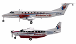
Warbelow's Air Venture, Beechcraft B1900C 'N121WV' and Cessna C208B Grand Caravan 'N999WV'. Missing repaints for Warbelow's Air winter 2009-2010 Flightplans by Steve Lewis (AVSIM) file : "warbelow_s_w09-10.zip". Textures only for Henry Tomkiewicz (HTAI) Beechcraft B1900C and Cessna C208B, AI freeware models.
| Filename: | Warbelows_Air_Venture_Beechcraft_B1900C_N121WV_and.zip |
| License: | Freeware |
| Added: | 20th February 2011, 01:21:05 |
| Downloads: | 696 |
| Author: | Jacques Capdeville |
| Size: | 561.52 KB |
| Category: Flight Simulator X - AFCAD Files | |
| CYDF - Deer Lake Regional Airport / Deer Lake, Newfoundland and Labrador, Canada (v1.1) |
|
Images related to this file:
File Description:
CYDF - Deer Lake Regional Airport / Deer Lake, Newfoundland and Labrador, Canada (v1.1)
This airport update was made with the latest version of ADE (Airport Design Editor) and made for FSX as a replacement for the stock (default) airport. I've made several changes to the airport which are listed below. All these enchancements are as close to the real airport as I can get with stock library objects. I've used satellite images, terminal photos and maps throughout the whole process so building locations are as accurate as possible. Happy landings in the beautiful Canada!
Features:
*Expanded parking apron
*Main terminal building with commercial aircraft parking
*Seperate parking aprons for GA traffic
*Hangars and other airport buildings
*Airport vehicles and objects throughout the airport
*Parking lot with static vehicles
*Airport fire station with fire truck
*De-icing vehicle/runway plow
*Helipads
*Fuel tanks
*Runway lengthened to 8,000ft as per recent upgrade (v1.1)
*Vehicle paths corrected (v1.1)
(For more information on Endeavourai please visit our site at endeavourai.com or our forums at http://endeavourai.boards.net/)
| Filename: | CYDF__Deer_Lake_Regional_Airport__Deer_Lake_Newfou.zip |
| License: | Freeware |
| Added: | 9th August 2012, 17:15:43 |
| Downloads: | 626 |
| Author: | Jaison Diaz / Endeavour ai |
| Size: | 66.97 KB |
| Category: Flight Simulator 2004 - Original Aircraft | |
| Kenya Airways OC and NC Boeing 767-36N/ER 5Y-KQX V2.0 |
|
Images related to this file:
File Description:

SkySpirit2010 767-300 v5. Model features High resolution textures, Dynamic flexing wings, Body gear steering, Nose gear steering, Rudder lock, Ground spoilers, Low speed aileron locks at high speed, Fully animated control surfaces, Fully independent suspension, Trim Animation, Opening Passenger Doors, Animated tilting bogies, Rolling wheels, Animated thrust reverser's with reverser block doors, Detailed textures, Full night lighting, Crash affects, Ground Service Vehicles And more. Model Designer Hiroshi Igami/Yosuke Ube. Flight Dynamics Designer Warren C. Daniel. Masters by Philip Foglar. Livery by Philip Foglar.
| Filename: | Kenya_Airways_OC_and_NC_Boeing_76736NER_5YKQX_V20.zip |
| License: | Freeware, limited distribution |
| Added: | 3rd July 2011, 03:19:40 |
| Downloads: | 730 |
| Author: | Philip Foglar | SkySpirit2010 Team |
| Size: | 21.57 MB |
| Category: Flight Simulator 2004 - AI Aircraft | |
| Avianca Brasil "Star Alliance" Airbus A320-200 (PR-AVR and PR-OCQ) |
|
Images related to this file:
File Description:

Repaint of Avianca Brasil, Airbus A320-200 and A320-200 Sharklets Star Alliance , registration PR-AVR and PR-OCQ. You need the FAIB Airbus A320 base package. This is an AI only aircraft. FS9 and FSX textures included.
| Filename: | Avianca_Brasil_Star_Alliance_Airbus_A320200_PRAVR_.zip |
| License: | Freeware |
| Added: | 31st July 2015, 00:27:57 |
| Downloads: | 884 |
| Author: | Eduardo Mello |
| Size: | 3.63 MB |
| Category: Flight Simulator 2004 - Scenery | |
| Brevoort CWOB and BAF-3 radar plus Cartwright LAB-6 radar Canada |
|
Images related to this file:
File Description:
Brevoort airstrip and the BAF-3 radar it serves is on Brevoort Island, off one of the southeastern tips of Baffin Island and 140 miles east of Iqaluit. This scenery includes the BAF-3 buildings on the hilltop and those on the airstrip below, plus the roads connecting them and down to the beach landing area on the rocky coast. This scenery is made for the FSGenesis 76m terrain mesh for northern Canada, and there will be a repost of all my northern Canada airfields to suit this; I cannot think now why I never installed this mesh before. The AI reflects the use of civil airlines for resupply and transportation of personnel. Given the terrain the wind should be from the north so that ai lands using the 02 runway. Landing from the north will involve a terrain clash while take off towards the north will not as the climb out clears the hilltop. The video shows the 600 foot cliff at the runway threshold and an Air Tindi plane on the apron. Cartwright CYCA is on the Labrador coast and has been posted by Flight Ontario as part of their Goose Bay and Labrador Regional Airports sceneries. The nearby LAB-6 radar site is included here, connected to CYCA by an extended road. The site uses the same buildings as Brevoort and Saglek (posted recently) and although I have included them here as separate sceneries the contents can be placed in the same folders as Saglek with a saving in duplicated textures. The textures here are more accurate than Saglek so say yes to over-write; a downloader with personal experience of Brevoort noted that in reality they are lighter.
| Filename: | Brevoort_CWOB_and_BAF3_radar_plus_Cartwright_LAB6_.zip |
| License: | Freeware, limited distribution |
| Added: | 20th August 2017, 15:46:36 |
| Downloads: | 175 |
| Author: | Roger Wensley |
| Size: | 4.37 MB |
| Category: Flight Simulator 2004 - Scenery | |
| Komakuk Beach & Storm Hills DEW sites in Yukon and Northwest Territories, Canada |
|
Images related to this file:
File Description:
These are DEW line sites in northern mainland Canada, to the west of Tuktoyaktuk.
Komakuk Beach CWKB is not included in FS9 and is in the Yukon, only 20 miles from the Alaska border. It is, as the name suggests, close to the sea, and the gravel runway 3,600' by 125' has its western end almost on the beach.
There is no lighting and no signage and the airfield is officially listed as closed, but in fact is used during the annual maintenance and refuelling of the automated NWS (North Warning Station) close by and for any unscheduled servicing. This replaced the previous much older DEW station that was manned year round and had a lot more buildings.
Storm Hills CWSH is in the Northwest Territories, 43 miles south-southwest of Tuktoyaktuk, up on higher land at 810 feet ASL. The NWS (there was no previous DEW station at this site) is serviced by helicopter from Tuktoyaktuk and has a gravel landing pad on the north side of the station. It will show on a gps and it is 5 miles west of the distinctively shaped and large Parsons Lake. This too was not in FS9.
| Filename: | Komakuk_Beach__Storm_Hills_DEW_sites_in_Yukon_and_.zip |
| License: | Freeware, limited distribution |
| Added: | 16th July 2012, 18:56:09 |
| Downloads: | 304 |
| Author: | Roger Wensley |
| Size: | 1.68 MB |
| Category: Flight Simulator 2004 - Scenery | |
| Cape Hooper CWFH and FOX-4 DEW Line Station in Nunavut, Canada |
|
Images related to this file:
File Description:
Cape Hooper is around 60 miles north of Kivitoo (FOX-D) and 140 miles south of Clyde River CYCY on the northeast-facing coast of Baffin Island. FOX-4 is still in use as a new and mostly-unmanned North Warning System site was established there in 1990 before the DEW line station was closed in 1991. Actually the DEW line station was not "closed" as such, they just stopped using it. The site of FOX-4 is on the top of a bump at the end of one of many long promontories that stick out into the Davis Strait between Baffin Island and Greenland, close to the far eastern end that is called Cape Hooper. There is a gravel runway to the west, down at 65' ASL; it is only just over 3,000' long and most material was delivered by sea to the beach at the southern end of the runway. The runway is signed as
"324T - 144T" as this is Northern Domestic Airspace where all runways are signed "true" and not "magnetic"; it is 013/193 magnetic with a huge magnetic variation of 48.9 degrees in this area where the magnetic field is mostly vertical, and so useless for navigation.
| Filename: | Cape_Hooper_CWFH_and_FOX4_DEW_Line_Station_in_Nuna.zip |
| License: | Freeware |
| Added: | 11th July 2011, 00:28:40 |
| Downloads: | 411 |
| Author: | Roger Wensley |
| Size: | 1.65 MB |
© 2001-2026 AVSIM Online
All Rights Reserved
Privacy Policy |