
Where Flight Simulation Enthusiasts Gather from Around the World!
AVSIM Library - Search Results

| Category: Flight Simulator 2004 - Scenery | |
| Dervio scenery - Como lake Italy |

|
Images related to this file:
File Description:
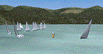
Scenery homage to a beautifull little town in north of Como lake of Italy; builded-up mainly with some existing objects and some buildings sintax made. It DOES NOT INCLUDE any airport, but represents only some pictures of Dervio town, reachable from Como Idroscalo floating airport or Samolaco or Sondrio Caiolo airports (closest ones); this is one of the moorings of Navigazione del Lago di Como. Informations: Dervio is one of the beautiful towns on north east area of Como lake, on a handland created by Varrone river. North and closed to the town, you can find Corenno Plinio old castle and in the opposite side of the lake the S. Bernardo church; you can also have some fireworks, obviously suggested with the night. Contents:
Mooring pier at snack bar, with awning and tables; Ferryboat in the lake with some sailbots in race between two buoys; Walk alongside the shore of the lake, with benches and some fisher piers; Main church with related church house and footbal soil; Several buildings, parking area, factories, bar and restaurant with tables chairs and gazebos, gas station and cars; Rail station with a small train and road gates; Sailbots on ground inside Centro Vela Dervio area and slipway with dinghy; Little marina with boats; Public park with entering gate, covered stand and tables; Residence La Boldona bloks with buildings, swimmin pool and tennis facilities, fenced; Campsite with campers, roulottes and tents; Corenno Plinio castle with tower and S. Bernardo little church; Spread of trees in all the scenery; (night scenery)two floating platforms wiht fireworks; six wood bonfires on shore of lake and on the mountains; One big ship with some other sailboats and speedboats
| Filename: | Dervio_scenery__Como_lake_Italy.zip |
| License: | Freeware |
| Added: | 22nd February 2011, 22:59:46 |
| Downloads: | 950 |
| Author: | Aldo Della Vedova |
| Size: | 12.71 MB |
| Category: Flight Simulator 2004 - Scenery | |
| Abruzzo-Molise L'Aquila, Italy |
|
Images related to this file:
File Description:
Abruzzo & Molise, Italy, Photoreal Scenery (26 june 2007).
Freeware scenery for FS2004.
All files of my scenery ABRUZZO & MOLISE: Abruzzo & Molise 1 - Campobasso.zip
Abruzzo & Molise 2 - Pescara.zip
Abruzzo & Molise 3 - Gran Sasso.zip
Abruzzo & Molise 4 - L'Aquila.zip
Author: Angelo Lanzillotta
e-mail: [email protected]
This photoreal scenery is based on aerial photos grabbed at the resolution of 5 meters per pixel (the same used in FS2004- works in FS 2002 too). I worked hard on these photos to obtain a final product with the real colours and the real positions for all parts of the landscape: if you have any comments or suggests, feel free to email me.
Every single part of this scenery can be used also as a standalone product, so it's not necessary to download all 4 parts of my big scenery.
However i strongly suggest to use all parts in order to obtain a complete photoreal look of this beautiful italian landscape, with famous mountains like Gran Sasso and Maiella.
INSTALLATION: 1) extract the files in a directory of your choice using the option: Use folder names.
2) Open FS and add the scenery to the scenery library (order isn't important).
For best results, use this scenery in association with Pietro Mauri Italymesh2004.
DISCLAIMER
This scenery is released as freeware, so nobody can make money with it.
You cannot include this scenery in any software collection or web site without written permission of author.
You can add objects and autogen (i had no time to work on them).
This software can be used only as FSX/FS2004/FS2002 scenery: no other use is allowed.
I accept absolutely no responsibility for your use of this software.
Re Uploaded in Oct. 2012 by Roberto (Tenex) Italy Terni(TR)
| Filename: | AbruzzoMolise_LAquila_Italy.zip |
| License: | Freeware, limited distribution |
| Added: | 10th October 2012, 22:37:18 |
| Downloads: | 1,096 |
| Author: | Enzo Lanzillotta |
| Size: | 87.93 MB |
| Category: Flight Simulator 2004 - Scenery | |
| PABA - Barter Island (Kaktovik) - Alaska North Slope 8 |
|
Images related to this file:
File Description:
The town of Barrow is in the far north of Alaska, and these are coastal villages or radar installations to the west, south, and now east of Barrow. There will be further additions. Barter Island is a DEW station Air Force base 310 miles east of Barrow and 75 miles east of Bullen Point. The runway is just under 5,000 feet of gravel and aligned 06-24 on a spit of land at the northeast corner of the island. The big hangar is still there on the apron. Most of the DEW buildings have now been removed but this scenery is dated around 2005 when there were more of them still there. Between the DEW station and the airstrip is the village of Kaktovik, with a population of some 300 mainly traditional Inupiat. The village was first pioneered when the DEW station was built in the 1950's and grew as the years passed. The FS9 error discovered when making this scenery was that FS9 had mistakenly "placed" Kaktovik at Bullen Point (not physically, it was just wrongly stated as the local town); this is now only partly corrected as FS9 refused to accept my Bullen Point revision but allowed me to associate Kaktovik with Barter Island. Kaktovik is definitely on Barter Island. I could also mention that the runway was in the sea, but there isn't much point in that as Bill would say it was all the fault of Ultimate Terrain, so I won't bother. The next DEW station to the east is in Canada and called Komakuk; this has already been made and posted. The next in this series will be far to the west. The AI has daily flights by ERA, plus Northern Air Cargo, and some GA.
| Filename: | PABA__Barter_Island_Kaktovik__Alaska_North_Slope_8.zip |
| License: | Freeware, limited distribution |
| Added: | 19th July 2016, 17:49:16 |
| Downloads: | 208 |
| Author: | Roger Wensley |
| Size: | 3.42 MB |
| Category: Flight Simulator 2004 - Scenery | |
| Alaska North Slope 9; Point Hope PAPO |
|
Images related to this file:
File Description:
The town of Barrow is in the far north of Alaska, and these are coastal villages or radar installations to the west, south, and east of Barrow on the North Slope. There will be further additions. Point Hope is a village on a spit of land that is one of the oldest and continuously inhabited places in all of North America, not just the polar regions. The "Point" is what brought this about, migrating whales passing close to land as they rounded the point, and the traditional way of life continues to this day. The population is now around 670. The airport surpassed all my expectations of FS9. Go look at the area before you install this. The first thing you will notice is that FS9 does not list Point Hope PAPO. The town is there (way too big and in totally the wrong place) and the airport background is there (wrong place of course) but there is no airport! Some buildings, but no runway, no apron, nothing that can be used by a plane?!? In real life the town is 3 miles east of the point, the runway is situated between town and point and, unusually in the north, is asphalt. This is presumably possible because of the gravel make-up of the point itself, with very little vegetable content and the warming sea restricting permafrost movements. 4,000 feet of 75 feet wide asphalt, lit, PAPI at both ends, and aligned 01-19. The building that appears to be wrongly situated away from the apron is like that intentionally; it is a helicopter hangar (not used in winter?) and they presumably did not want the apron traffic to get in their way. The AI has daily flights by ERA, plus Northern Air Cargo, and some GA.
| Filename: | Alaska_North_Slope_9_Point_Hope_PAPO.zip |
| License: | Freeware, limited distribution |
| Added: | 25th July 2016, 20:20:35 |
| Downloads: | 254 |
| Author: | Roger Wensley |
| Size: | 3.02 MB |
| Category: Prepar3D V1-4 - Aircraft Repaints, Textures and Modifications | |
| North American P-51D 353rd FG (YJ-L) "Willit Run?" |
|
Images related to this file:
File Description:
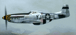
This folder contains a repaint for the A2A WoP3 P-51D Mustang, in the colors of P-51D-10-NA 44-14771 YJ-L "Willit Run?" which flew with the 351st FS, 353rd FG from Raydon in the UK, with Maj Frederick LeFebre as its regular pilot. The P-51 is named “Willit Run?â€, but the nose art on this plane is not talking about this particular aircraft or any P-51 for that matter. It’s an inside joke of WWII vintage.
During WWII, as in every big war, private industry is called upon to produce war goods rather than civilian goods – “guns vs. butterâ€. Henry Ford took on a huge project to contract-build Consolidated B-24 Liberator bombers in a new state-of-the-art manufacturing facility to be built on a farm which Henry Ford owned at Willow Run near Detroit. The facility was to be a prime example of Roosevelt’s “Arsenal of Democracyâ€, conceived and built on an unprecedented scale. Begun in April, 1941, it was the largest enclosed room in the world, with 3.5 million square feet. But Willow Run had a long and troubled construction and start-up time. So long and troubled a start-up, that after two years with little results the public became disillusioned with the project and derisively nicknamed the plant “Willit Run?â€.
Ford persevered however, and Willow Run finally hit its stride, eventually producing at the prodigious rate of 650 B-24 bombers per month by August, 1944. At war’s end, Willow Run had produced about half of the 18,000 B-24's which saw service in the war.
Repaint by Jan Kees Blom, based on the A2A paintkit.
| Filename: | North_American_P51D_353rd_FG_YJL_Willit_Run.zip |
| License: | Freeware |
| Added: | 18th November 2018, 16:21:26 |
| Downloads: | 61 |
| Author: | Jan Kees Blom |
| Size: | 12.3 MB |
| Category: Flight Simulator X - Aircraft Repaints, Textures and Modifications | |
| DDA Classic Airlines PH-PBA 2019 Douglas C-47 (DC-3) 75 YEARS! |
|
Images related to this file:
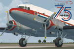
File Description: For Manfred Jahn's C-47 with Jan Visser's VVC, version 3.14 repaint of DDA
(Dutch Dakota Association) Classic Airlines. The only flying DC-3/C-47 in the
Netherlands at the moment. Hopefully joined by her sister (PH-DDZ) in the near
future. The new 2018 livery of the DDA Dakota is going back to it's roots, as it royal
colours in which it flew in the '50 and '60. Now updated with the "75 years"
logo. The aircraft is 75 years old this year. Besides the new logo, the following was updated:
- The Red colour was made a bit brighter __
- Adjustments on several locations (Reallife paint was not 100% the drawings ;-) __
- Several (small) details added on the outside, incl new prop textures __
- Several gauge bitmaps modified (most noticable the Airspeed indicator) __
- Some bitmaps of the VC modified __ For more info on the real DDA visit there site: https://www.dutchdakota.nl/en/home/ Besides the outside, the inside and the pilot's got a different look. Also
added some more details, especially at the tires and gear struts.
The VC textures are repainted to get the cockpit as much in line with the real one. Big thanks to Manfred Jahn and his team for creating this beautiful model and
Jan Visser and his team for all the work done to improve this model even further.
Ted "TuFun" Wolfgang for the improved engine textures. For this repaint the
excellent paintkit by Gordon "Gman5250" Madison was used. Works both in FSX
and Prepar3D. Special thanks to Paul van den Berg from DDA Classic Airlines
for providing the original paint drawings and beta testing the livery.
---> Works both in FSX and Prepar3D
| Filename: | DDA_Classic_Airlines_PHPBA_2019_Douglas_C47_DC3_75.zip |
| License: | Freeware, limited distribution |
| Added: | 15th March 2019, 16:39:46 |
| Downloads: | 736 |
| Author: | Marcel Ritzema |
| Size: | 38.42 MB |
| Category: Flight Simulator 2004 - AI Flight Plans | |
| TUI Airlines Belgium Winter 04-05 (version 2) |
|
File Description:
FS2002/2004 "TUI Airlines Belgium" representative charter flight plans for the winter 2004-2005 period, which have been compiled according to the company information for the week 07 Mar 2005 - 13 Mar 2005.
This version is an UPDATE of my previous release due to the arrival of their own Boeing 767-300ER.
TUI Airlines Belgium (TUB) is a charter airline based in Belgium, flying with three 737-400, two 737-800W, and one 767-300ER from its main base Brussels-National as well as from regional airports of Liège and Oostende.
As for all charter company, flights differs from one week to one another but this file comprises its main destinations regularly visited throughout the winter period.
The TUB winter season flights comprises both medium- and long-haul destinations from Brussels, Liège and Oostende-Brugge to Agadir, Alicante, Almeria, Cancun, Djerba, Faro, Fuerteventura, Hurghada, Lanzarote, Las Palmas, Luxor, Malagà, Marrakech, Monastir, Montego Bay, Pafos, Palma de Mallorca, Puerto Plata, Punta Cana, Santa Cruz (La Palma), Sharm el Sheikh, and Tenerife-Sur, and Varadero.
As from spring 2005, TUB will launch scheduled services to Agadir, Cairo, Marrakech, Tanger, Toulon, as well as new charter flights to Ajaccio, Bastia, Marsa Alam, Funchal, plus many other charter destinations to Bulgaria, Croatia, France, Greece, Italy, Spain, Tunisia and Turkey. Also, a new aircraft type will be introduced in the fleet in the form of the Fokker 100 ::: stay tuned for summer season flightplans release :::.
Schedule files fully compatible with Traffic Tools by Lee Swordy (available on this site).
| Filename: | TUI_Airlines_Belgium_Winter_0405_version_2.zip |
| License: | Freeware |
| Added: | 5th March 2005, 22:30:32 |
| Downloads: | 1,060 |
| Author: | Jean-Philippe DELWICHE |
| Size: | 7.31 KB |
| Category: Flight Simulator 2004 - AFCAD Files | |
| MATVA Afcads 7 |
|
File Description:
More improved airfields to replace those default airfields Microsoft have seen fit to provide little or no facilities at. The MATVA Group, www.matva.org.uk offer you another package of Af2 files for those airfields they visit, they do not have allocated gates. The 68 airfields in this package are:(EGPD) Aberdeen and (EGPM) Scatsta, Scotland, (LGAV) Athens, (LGRP) Rodos, (LGTS) Thessaloniki, (LGAL) Alexandropolous, Greece, (LGIR) Iraklion and (LGSA) Chania, Crete, (LTBJ) Izmir, Turkey, (LJLJ) Ljubljana, Slovenia, (LATI) Tirana, Albania, (LROP) Bucharest, Romania, (LYBE) Belgrade, Serbia, (LIPE) Bologna, Italy, (LWSK) Skopje, Macedonia, (LBSF) Sofia and (LBBG) Burgas, Bulgaria, (LHBP) Budapest, Hungary, (LPPR) Porto, Portugal, (EKEB) Esbjerg, Denmark, (FOOL) Libreville, (FOOT) Tchibanga, (FOON) Franceville and (FOOG) Port Gentil, Gabon, (DIAP) Abidjan, Cote D'Ivoire, (GFLL) Freetown, Sierra Leone, (DFFD) Oagadougou, Burkina, (GMME) Rabat, Morocco, (FLLS) Lusaka, Zambia, (HDAM) Djibouti, (GLRB) Monrovia, Liberia, (HUEN) Entebbe, Uganda, (DRRN) Niamey, Niger, (FVHA) Harare, Zimbabwe, (HTDA) Dar-Es-Salaam, Tanzania, (HHAS) Asmara, Eritrea, (FKKD) Douala and (FKKN) N'gaoundere, Cameroon, (FQBR) Biera, Mozambique, (FNLU) Luanda, Angola, (FYWH) Windhoek, Namibia, (HAAB) Addis Ababa, Ethiopia, (FCBB) Brazzaville, Congo, (FAJS) Johannesburg, (FGBT) Bata and (FGSL) Malabo, Equatorial Guinea, (FMMI) Antananarivo, Madagascar, (FPST) Sao Tome and (FPPR) Principe, Sao Tome et Principe, (FIMP) Mauritius, (FSIA) Seychelles, (GCXO) Tenerife North, (MMUN) Cancun and (MMAA) Acapulco, Mexico, (OERK) Riyadh, Saudi Arabia, (TBPB) Barbados. (SAEZ) Beunos Aires.
Also included are reworks of our previously released (HELX) Luxor, (RJBB) Osaka, (LGKR) Kerkira, (FACT) Cape Town, (FADN) Durban, (HKJK) Nairobi, (LFLL) Lyon, (DGAA) Accra, (FEFF) Bangui, Central African Rep. (GOOY) Dakar and (DAAG) Algiers. Enjoy :O)
| Filename: | MATVA_Afcads_7.zip |
| License: | Freeware, limited distribution |
| Added: | 23rd July 2006, 07:31:28 |
| Downloads: | 10,084 |
| Author: | Louie Maclennan MATVA |
| Size: | 242.36 KB |
| Category: Flight Simulator 2004 - Scenery | |
| Zion National Park North, Cedar Breaks National Monument, Cedar City (KCDC), Utah, Photo-Scenery (FS9 & FSX) |
|
Images related to this file:
File Description:
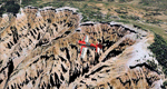
Cedar Breaks National Monument is a large amphitheater cliff in bright colors of red, orange and purple.
It lies east of Cedar City in the northern region of the scenery. The cliff was formed by erosion thru wind,
water and ice. Today erosion continues with a pace of about 2 inches every 5 years. Although it is called
Cedar Breaks, there are no cedars growing there but juniper trees. For a scenic flight to Cedar Breaks
National Monument best depart from Cedar City Regional Airport (KCDC) and head east. The scenery extends
south to Zion National Park and covers a large part of Zion Canyon and the Kolob Canyons area.
Zion National Park is another place where erosion of the Colorado Plateau formed the most beautiful colorful
stone formations of unique and wonderful shapes. There are nine different layers of stone visible in the park.
Most of them consist of sandstone. But there is also limestone, gypsum, siltstone, shale, clay and mudstone.
The Virgin River cut a spectacular and famous canyon thru Zion Park that is as narrow as 20ft and up to 2000ft tall.
High resolution versions of this scenery for FS9 and FSX (much sharper, but larger and multiple downloads)
are available at www.blueskyscenery.com/CNY_South2West5.html . The screenies are taken from the high-res versions,
so expect this version to be slightly more blurry.
Thanks to Joop Mak for providing a custom AFCADs that correct airport layouts so that they align with the photo-textures!
They are available here: www.blueskyscenery.com/AFCADs.html . YourDonation@Work: Dedicated to Richard, P.J. and Felix.
| Filename: | Zion_National_Park_North_Cedar_Breaks_National_Mon.zip |
| License: | Freeware, limited distribution |
| Added: | 14th March 2010, 00:30:28 |
| Downloads: | 1,564 |
| Author: | Gottfried Razek - blueskyscenery.com |
| Size: | 97.13 MB |
| Category: Flight Simulator 2004 - Scenery | |
| CNZ3 - Chatham-Kent - Ontario, Canada V1 |
|
Images related to this file:
File Description:
This is partly part of the Small Ontario Fields series. The airport ICAO was changed from CNZ3 to CYCK in November 2012; I have left it as it was. The runway too remains as it was a few years ago. Chatham is located 50 miles east of Detroit and 150 miles southwest of Toronto, between Lake St. Clair and Lake Erie, and the airfield is southeast of the town. There is a single asphalt runway 5,000 feet long and 75 feet wide, aligned 05/23 in FS9 but in fact in real life now 06/24 due to the wandering magnetic north. The apron is on the northern side of the runway at the eastern end, with added taxiways to cater for newer hangars wearing identical colour schemes. There is fuel, runway lighting, some taxiway lights, visitor parking on the grass, and plane maintenance in the large hangar beside the small terminal building on the north side of the apron. There is a train station in the middle of the town, and no scheduled flights to the airport that is 8 miles away; these two facts may be connected. Ditches along the road and around much of the airfield provide separation, which is why the fences are not continuous. If you are on the runway and find your path to the apron blocked by another plane that is stationary at the hold short, continue past the first turnoff to the threshold markers and turn off the runway and wait. The AI plane will then taxi out and you will have a clear path.
| Filename: | CNZ3__ChathamKent__Ontario_Canada_V1.zip |
| License: | Freeware, limited distribution |
| Added: | 27th August 2015, 21:02:59 |
| Downloads: | 341 |
| Author: | Roger Wensley |
| Size: | 9.89 MB |


© 2001-2026 AVSIM Online
All Rights Reserved
Privacy Policy |