
Where Flight Simulation Enthusiasts Gather from Around the World!
AVSIM Library - Search Results

| Category: Flight Simulator X - Scenery | |
| X2AD - RAF Aston Down - Gloucestershire, England |

|
File Description:
Former RAF Aston Down (IACO X2AD) is located 2.5 miles (4.0 km) east of Minchinhampton, Gloucestershire, South West England and 6.9 miles (11.1 km) west of Cirencester, Gloucestershire.
The airfield was originally opened as RAF Minchinhampton and was first used in the First World War, serving as an aerodrome for the Australian Flying Corps with No. 2 Squadron AFC flying the Royal Aircraft Factory S.E.5a and the Sopwith Pup and No. 3 Squadron AFC flying the Avro 504. The airfield closed shortly afterwards.
In 1938 the airfield reopened under the new name of RAF Aston Down at the request of the residents of Minchinhampton village, which lies about 1 mile (1.6 km) to the west of the airfield, who feared not enemy attack, but a fall in the value of their houses.
During the Second World War the main unit present was No. 20 Maintenance Unit RAF (MU) which stored and prepared aircraft. The unit arrived during October 1938 and left in September 1960.
The airfield was used by the Royal Air Force from the First World War until 1967 when the Cotswold Gliding Club moved in from their previous base near Tetbury.
| Filename: | X2AD__RAF_Aston_Down__Gloucestershire_England.zip |
| License: | Freeware |
| Added: | 3rd May 2016, 13:55:23 |
| Downloads: | 175 |
| Author: | Terry Boissel |
| Size: | 1.97 MB |
| Category: Flight Simulator 2004 - Scenery | |
| Port McNeill CAM8 float base in British Columbia, Canada |
|
Images related to this file:
File Description:
This is the seventh in a series of new and renovated float bases in BC. Port McNeill is a float base in a sheltered inlet on the northeast coast of Vancouver Island, close to the town and just under 20 miles east of the Port Hardy float base. There is no fuel available as the Port Hardy floatbase (already posted) acts as a refuelling centre for this and other float bases in the neighbourhood. The dock is to the west of the marina and east of the log raft area. The AI is a further adaptation of the CF36 AI and involves Beavers as listed in the AI folder. At Port McNeill all the AI works for both landing and takeoff for all of the planes, no matter what the wind direction is. All of these float bases can be installed together in the same folders, with a saving in duplicate textures. So a series called BC Floats (or whatever you want to call it) or individually installed float bases; your choice. The next in the series was suposed to be Sullivan Bay, another floating marina, but I digressed to Port Hardy and Port McNeill.
| Filename: | Port_McNeill_CAM8_float_base_in_British_Columbia_C.zip |
| License: | Freeware, limited distribution |
| Added: | 21st January 2017, 19:11:03 |
| Downloads: | 171 |
| Author: | Roger Wensley |
| Size: | 5.07 MB |
| Category: Flight Simulator X - Aircraft Repaints, Textures and Modifications | |
| GMG Airlines Boeing 737-800 |
|
Images related to this file:
File Description:

GMG Airline was established in 1997 and started domestic operations on 6 April 1998. International services were launched six years later on 8 September 2004, with a service from Chittagong to Kolkata.
GMG began regular flights to Bangkok, Delhi and Kathmandu on 20 October 2006. It started services to Kuala Lumpur on 24 January 2007. The airline started its operation to the Middle East with daily flights to Dubai on 1 February 2008. In July 2010, GMG initiated flights to Jeddah and Riyadh.
The airline also served Abu Dhabi and Karachi as well as domestic stations Jessore and Sylhet
A GMG Airlines Bombardier Dash 8 In February 2008 the airline added a leased Boeing 747-300 to the fleet starting wide-body operations, this proved to be a White Elephant in an era which saw Global economic problems and an unprecedented peak in oil prices, thus causing a substantial loss to the carrier, the 747 was eventually phased out after just five months of service.On 17 June 2009, the largest conglomerate of Bangladesh, BEXIMCO took a 50% stake in the airline, re-branding it and raising service standards to a higher level. For the PMDG 737NGX-800
| Filename: | GMG_Airlines_Boeing_737800.zip |
| License: | Freeware |
| Added: | 27th November 2016, 22:04:14 |
| Downloads: | 136 |
| Author: | MacHelix1, PMDG |
| Size: | 19.32 MB |
| Category: Flight Simulator 2002 - AFCAD Files | |
| Denver International Airport KDEN with WestWind Terminal Overlay |
|
File Description:
This is a 4 part (base and 3 overlays) FS2002 facility file for KDEN. This file can be used with the WestWind Training Center scenery file available from http://www.flywestwind.com/Scenery/denverterm.htm. The base file is named KDEN1BB.txt, is for non-express/non-regional commercial aircraft,
not of the WestWind livery, uses runways 35L for departures and 35R for arrivals, and has 8 heavy gates, 14 medium gates, and 20 small gates. The first overlay is named KDEN2BB.txt, is for express/regional commercial aircraft, not of the WestWind livery, uses runway 26 for departures and arrivals, and has 19 small gates. The second overlay is named KDEN3BB.txt, is for general aviation aircraft, uses runway 7 for departures and arrivals, and has 7 parking spaces. The third overlay is named KDEN4BB.txt, is for all commercial aircraft of the WestWind livery only, uses runway 16 for departures and arrivals, and has 1 heavy gate and 13 small gates. You do not have to utilize the WestWind overlay if you do not want to, it will not affact the scenery and the remainder of the airport will work fine if you simply ignore it.
| Filename: | Denver_International_Airport_KDEN_with_WestWind_Te.zip |
| License: | Freeware |
| Added: | 18th November 2002, 00:15:30 |
| Downloads: | 458 |
| Author: | Boyd Barker |
| Size: | 78.13 KB |
| Category: Flight Simulator 2004 - Scenery | |
| North Haledon Lite |
|
File Description:
This is Chopper Friendly scenery, folks. It wasn't designed to be flown over at 10,000 feet - although, if you like to fly heavy iron into the major New York/New Jersey airports, you'll notice that it replaces the terrain elevation of Northern New Jersey with all the hills and valleys that the default scenery left out. No, this is interactive scenery. Built to be explored low and slow.
Want to perfect your landing skills in a huge playground of rooftops, irregular terrain, and tight spaces? This is the place. You won't find any unlandable surfaces or false crashes here - just hundreds of places to touch down ranging from beginner, through expert, to downright sick!
This is the lite version, designed for people who are having trouble with the frame rates of the full version. I've thinned out the houses and trees, and removed the buildings South of Oldham Pond - but managed to keep most of the interesting places to land. In the tests I've done, there was about a 20 percent frame rate increase on average compared to the full version, with nearly a 45 percent increase in the most framerate-hostile areas.
| Filename: | North_Haledon_Lite.zip |
| License: | Freeware, limited distribution |
| Added: | 1st June 2006, 04:48:01 |
| Downloads: | 656 |
| Author: | Mick Posch |
| Size: | 11.38 MB |
| Category: Flight Simulator X - Original Aircraft | |
| F-15 S/MTD |
|
File Description:
This is my second release for the FS community.
The F-15 S/MTD is a STOL variant of the all-weather tactical
fighter F-15 Eagle. While S/MTD stands for Short take off and landing
/Maneuver Technology Demonstrator, the actual plane has F-18's elevators
as canard wings and a two-dimensional thrust vectoring, which gives the
aircraft an exceptionnal maneuvrability. Developed as a technology
demonstrator, the F-15 S/MTD carried out research for studying the
effects of vectored thrust and enhanced maneuverability. The NASA has
modified an F-15 Eagle by adding canard wings and by replacing the
original engines nozzles by two Pratt & Whitney P/YBBN 20 Degree
two-dimensional thrust vectoring nozzles. The F-15 S/MTD can also
perform the famous "Pugachev's Cobra" maneuver. The same aircraft would
later be used for the F-15 ACTIVE (with three-dimensional vectored
thrust) and for the F-15 IFCS (with three-dimensional vectored thrust
and with improved avionic). Features all the basic animations
(retractable landing gear, steering wheel, working suspension, working
surfaces plus thrust vectoring nozzles and moving engines inlets) and
afterburner. Sorry, no VC.
Model made in Gmax by Thomas Lebel.
| Filename: | F15_SMTD.zip |
| License: | Freeware |
| Added: | 19th February 2008, 00:35:34 |
| Downloads: | 3,268 |
| Author: | Thomas Lebel |
| Size: | 4.85 MB |
| Category: Flight Simulator 2004 - Scenery | |
| Johnson Creek 3U2 Forest Service airfield in Idaho USA |
|
Images related to this file:
File Description:
This airfield is in the mountains of Idaho, around 25 miles south of Big Creek U60, which was the second in the series to be posted. Johnson Creek is very regularly used for picnic fly-ins and overnight camping, as can be seen from the number of videos posted. Again, the creek does not appear in FS9 as it is only around 20 feet or so wide, plus within Ultimate Terrain I have streams turned off for the reasons given in the U60 post. The runway is at 4,933 feet ASL, 3,480 feet long, aligned 35-17, and in good condition. The shower facilities are south of the centre of the runway and on the eastern side; as a result planes mostly, but not all, park on the eastern side and towards the south. There are Forest Service workshop buildings on the east side of the runway near the centre. If you have a wind from the south then some AI planes will actually manage to land. I should have mentioned before that these are all made with only the default FS9 mesh, and that I will be reposting them again for use with the FSGenesis 19m mesh.
| Filename: | Johnson_Creek_3U2_Forest_Service_airfield_in_Idaho.zip |
| License: | Freeware, limited distribution |
| Added: | 25th May 2017, 17:54:06 |
| Downloads: | 172 |
| Author: | Roger Wensley |
| Size: | 4.81 MB |
| Category: Flight Simulator 2004 - Scenery | |
| Alaska North Slope 5 - Nuiqsut PAQT |
|
Images related to this file:
File Description:
The town of Barrow is in the far north of Alaska, and these are coastal villages or radar installations to the west, south, and now east of Barrow. There will be further additions. Nuiqsut is a mainly Inuit community on the west side of the Colville River, around 20 miles south of the coast, and with a slowly declining population of around 420 or so. The airfield is just south of the town and has a gravel runway 5,000 feet long and aligned 04-22 in FS9. The airfield is the only year-round contact route to the rest of the world, though there are plans for a permanent road. The AI includes daily passenger flights early and late in the day, cargo deliveries, and some GA. It seems that the only photos I had of the airport were either of the old building or were not of Nuiqsut at all. The only pic I have seen (recently, which is why I now have doubts) of the new building is insufficient to model it, so I am sticking with the old or maybe incorrect version.
| Filename: | Alaska_North_Slope_5__Nuiqsut_PAQT.zip |
| License: | Freeware, limited distribution |
| Added: | 21st June 2016, 21:45:32 |
| Downloads: | 246 |
| Author: | Roger Wensley |
| Size: | 4.37 MB |
| Category: Flight Simulator X - Gauges | |
| Advanced Radar System 4 (ARS4) |
|
Images related to this file:
File Description:
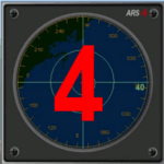
This gauge has been developed for FSX Flight Simulator SP1 or SP2. It
has also been tested with Microsoft Acceleration also, but compatibility is not guaranteed by the author.
This new Advanced Radar System (ARS 4) includes significant new features,
functions and displays for FSX AI traffic. The new key features are:
1)AI traffic display for air targets and boat/ship targets.
2)Auto landing on carrier if the carrier is part of the scenery MECOPS.
3)Allows switching between air target display and boat target display.
4) Provides for air and boat display to optionally insert airport and/or basic terrain display on the screen.
5)Different screen presentations for air and boat targets.
6)Simplified installation procedure.
7)The A2A re-fuel function remains the same as in the ARS2 version.
8)The auto tracking function remains the same as well as in the ARS2 version.
All displays for air, or boat/ship traffic, can be selected in a range of 5, 10, 20, and 40 miles.
For installation and additional information look at the ARS4 documentation inside the zip file. For copyrights and credits please look at the documentation for this gauge.
| Filename: | Advanced_Radar_System_4__ARS4.zip |
| License: | Freeware |
| Added: | 5th March 2013, 15:53:52 |
| Downloads: | 3,813 |
| Author: | Dietmar Loleit |
| Size: | 1.18 MB |
| Category: Flight Simulator X - Missions | |
| FSX/MSFS - FSX-RWT_v2-0 : FSX Real World Training Missions - Includes MSFS compatible flight files |
|
File Description:
New with version 2-0 :
- MSFS Supports (Missions flight files, ready to be loaded into MSFS Free Flight environment. MSFS Preset Weather files for all the missions.
- Three new missions
- Chap_24_Multiplayer : The Icefields Parkway Photo Shoot.
- Chap_25_VirtualL_Airlines: First Solo Flight over the Atlantic.
- Chap_26_Virtual_ATC: First English Channel Crossing.
- Consolidate all changes brought through update v1-1, v1-2, v1-3 & v1-4.
- Access to a Scenario Browser window from the overview panel.
- Scenarios, Charts and pictures can be viewed in separate windows while flying the mission.
Integrates into the FSX environment the flight exercises from the "FSX Real World Trainning for Pilots" book.
All the files have been grouped into a new FSX Mission Category: Real World Training.
Under the FSX Mission panel, this new category provides the following access:
* Over 100 Flights exercises from the book:
- BEGINNER: covers Chapter 2 thru Chapter 9.
- INTERMEDIATE: covers Chapter 10 thru Chapter 14.
- ADVANCED: covers Chapter 15 thru Chapter 19.
- EXPERT : covers Chapter 20 thru Chapter 26, plus the two Bonus Chapters.
The scenarios describes "What to do" only. please refer to the book for the "Why" and "How".
| Filename: | FSXMSFS__FSXRWT_v20__FSX_Real_World_Training_Missi.zip |
| License: | Freeware, limited distribution |
| Added: | 12th January 2021, 23:09:33 |
| Downloads: | 275 |
| Author: | Gilbert Laprise |
| Size: | 182.09 MB |


© 2001-2026 AVSIM Online
All Rights Reserved
Privacy Policy |