
Where Flight Simulation Enthusiasts Gather from Around the World!
AVSIM Library - Search Results

| Category: Flight Simulator X - Flight Plans | |
| Operation Sky Light |

|
File Description:
In the early cold dawn of February 7, 2008 the sky of Siberia was
lighted by a yellowish light accompanied
by a sound similiar to Rock & Roll Drums....in this barren land very
few saw or heard it. Radar Station "Kipowlsky-33" in
lower Siberia recorded a falling object for 20 minutes then lost it.
Enrico Flemmi of the Italian Space Watch Observatory has told the
Roman Daily that all electronic devices placed by the observatory in
Siberia have shut down, 65 of them!!....Stritch
Gunswarsek, of the EU Scientific Laboratory for the studies of the
Atmosphere has declared that a high
level of Ozone has been detected from ground 0 to 24,000 feet over
all Siberia...........
In response, Operation " Sky-Light" has been authorized with priority
" Secret + 999" meaning that all Special planes
equipped with " Alpha 323 Sensors" must go to Siberia and follow
procedure "Klinky-8989"--- Russia has agreed that UN NATIONS AIRCRAFT WILL BE ACCEPTED!!!!.
The penetrator must be found!!Is this time True???----If you go, do take a scarf.
| Filename: | Operation_Sky_Light.zip |
| License: | Freeware, limited distribution |
| Added: | 6th February 2008, 04:11:54 |
| Downloads: | 651 |
| Author: | Gera Godoy C |
| Size: | 384.81 KB |
| Category: Flight Simulator X - Scenery | |
| Branson Airport KBBG--New Airport, Scenery, and Flight Plans |
|
Images related to this file:
File Description:
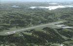
This project adds a new, detailed Branson Airport KBBG (Missouri) to FSX, which opened in May 2009, and is a privately developed commercial airport. The construction of the airport, which involved the flattening of several Ozark Mountains, is claimed to be the largest earthmoving project in Missouri history. As a result, the airport actually sits on a manmade plateau, surrounded by rolling hills. The airport uses the ICAO identifier BBG, however, the airlines use the IATA code BKG. The airport is served by AirTran, Frontier, and ExpressJet (Branson AirExpress), and is located in hilly terrain. Aircraft equipped with a terrain avoidance warning system may experience system activation on final approach. Birds are in the vicinity of the airport. AFCAD with sloping terrain created using Airport Design Editor X v1.47.07, and the hilltops were cleared and flattened and roads were added using SBuilderX 3.13. The terminal, hangar, FBO, and cars were added and modified from stock FSX scenery, using the FSX Object Tool, to resemble as closely as possible the actual airport.
| Filename: | Branson_Airport_KBBGNew_Airport_Scenery_and_Flight.zip |
| License: | Freeware |
| Added: | 5th August 2010, 01:08:33 |
| Downloads: | 2,005 |
| Author: | Carlyle Sharpe |
| Size: | 6.02 MB |
| Category: Prepar3D V1-4 - Scenery | |
| LRTR Traian Vuia P3D v4 |
|
Images related to this file:
File Description:
Timisoara RO LRTR V-4 (Released October 2017) for P3D v4- This scenery is an update of the stock Airport (ICAO code: LRTR).
What to expect? The entire airport has been updated with correct RWY, taxiways, aprons, COMM's (ATIS, GND, TWR), markings, parkings, roads, some buildings, lights and vegetation. All objects are from stock ADE! Entire work and object placing has been done using a photo overlay image from Google Earth, yet don't expect a photoreal scenery. The used background image has been removed due to Google's copyright policy. Due to using stock objects from library, don't expect perfect shape and colors of objects. I tried to customize the objects so that they look like the real ones. Basic shape and colors should match the real word buildings. NOTE: Some 3rd party addon's might change ground textures or building textures. I have also generated some own ground textures to match those of the airports. Unfortunately there is a problem with those textures not casting shadows. If you still want to see the shadows, you will have to turn on "Buildings" receieve shadows.
| Filename: | LRTR_Traian_Vuia_P3D_v4.zip |
| License: | Freeware |
| Added: | 8th October 2017, 01:15:58 |
| Downloads: | 905 |
| Author: | Gerald Krutsch |
| Size: | 1.07 MB |
| Category: Flight Simulator 2004 - Scenery | |
| HSSS Khartoum, Sudan |
|
File Description:
Googly scenery for HSSS Khartoum, Sudan. For Sudan's main international airport,
the Flight Simulator depiction is somewhat simplified, depicting just a few
buildings which are badly located. These scenery files attempt to reproduce
the real atmosphere of the airport - from the huge clutter of small hangars
and workshops and large quantities of inactive planes through to the aircraft
dump at the north end of the airport.
The scenery does not purport to be ultra-accurate. Based on high-detail satellite
imagery from Google Earth, the layout is proportionally correct but the added
airport features, such as buildings, are built from default Microsoft objects
and third-party object libraries so will not look like the real thing.
You are not obliged to download and install any additional scenery libraries,
but to enjoy this scenery in its entirety, you may wish to. It will work fine,
with or without. These files complement the Sudan Airways AI Fleet Pack by Billy Rutherford &
John Hinson, updating the scenery files contained therein, but the two are not
inter-dependent.
| Filename: | HSSS_Khartoum_Sudan.zip |
| License: | Freeware |
| Added: | 9th March 2007, 17:29:13 |
| Downloads: | 4,418 |
| Author: | John Hinson |
| Size: | 38.74 KB |
| Category: Flight Simulator X - Scenery | |
| RAF Bottlesford - Lincolnshire, England |
|
File Description:
Royal Air Force Station Bottesford or more simply RAF Bottesford is a former Royal Air Force station located on the Leicestershire-Lincolnshire county border, 6.8 miles (10.9 km) north west of Grantham, Lincolnshire and 7.6 miles (12.2 km) south of Newark-on-Trent, Nottinghamshire and about 107 miles (172 km) north-northwest of London, England.
Opened in 1942, it was used by both the Royal Air Force (RAF) and United States Army Air Forces (USAAF). During the war it was used primarily as a troop carrier airfield for paratroopers and as a bomber airfield before closing in 1948.
Today the remains of the airfield are located on private property with the technical site being used as an industrial estate.
Third party add-on's will be required to see all the building included in the scenery, you will need Ted Andrews RAF Small Buildings and his hanger library, for the vehicles Ian Pearson FSX Object library will be required, the RAF Ensign hedges are the from Mike Hudson's scenery. All of which are available from Ian Pearsons' website; www.ianpsdarkcorner.co.uk.
| Filename: | RAF_Bottlesford___Lincolnshire_England.zip |
| License: | Freeware |
| Added: | 10th October 2015, 11:37:40 |
| Downloads: | 346 |
| Author: | Terry Boissel |
| Size: | 15.94 KB |
| Category: Flight Simulator 2004 - AI Aircraft | |
| Antonov An-2 for AI Traffic Complete Package |
|
File Description:
Low-poly AI Antonov An-2 by Rysiek Winawer. Features 10 different visual, 7-LOD models, many animations and eye-candies. Flying on FDE by Mike 'Magic' MacIntyre. A paintkit by Mike Pearson included as well as 7 repaints. Expect military package(s), including the model, thanks to Military AI Works (MAIW) group members. A custom made Ketrzyn-Wilamowo EPKE scenery included, utilizing some EZ-Scenery library object (it will work without them though, an included AFCAD file and traffic BGL files are the most important).
Demo flightplans included. You may design own flightplans as well, using RPP_FPGen sheet.
The An-2 is the largest single-engine biplane ever produced. By 1960 the USSR had produced over 5,000 units. Since 1960, most An-2s have been built at Poland's WSK factory in Mielec, with over 13,000 made there before full production ended in 1991. Limited production from parts stocks, as well as spares and maintenance coverage continues. China also builds the An-2 under license as the Shijiazhuang Y-5.
See readme file for all copyrights and additional info.
| Filename: | Antonov_An2_for_AI_Traffic_Complete_Package.zip |
| License: | Freeware, limited distribution |
| Added: | 26th May 2008, 23:32:46 |
| Downloads: | 6,074 |
| Author: | Rysiek Winawer |
| Size: | 9.37 MB |
| Category: Flight Simulator 2004 - Scenery | |
| Alaska South Slope 12; Teller K54 |
|
Images related to this file:
File Description:
There are four main northwestern Alaska towns which are serviced by Alaska Airlines, and from which local flights spread out. The northernmost is Barrow. Southwest of Barrow is Kotzebue, then Nome, and the furthest south is Bethel (not yet made). This is the fifth in a series for local flights from Nome, and it is on the coast around 55 miles east of Wales and 55 miles northwest of Nome. There are two other airfields around a large lagoon that is almost totally enclosed from the sea, and Teller is on the easten shore, just 15 miles east of Port Clarence and 5 miles southeast of Brevig Mission, both already posted. Teller has a populaton of around 230, down from the 5,000 or so in the early 1900's after the Bluestone Placer Mine struck gold. Tollef Brevik was a Lutheran missionary who was both a pastor and teacher for the Inuit in the area from 1894 onward, travelling from community to community but based in Teller, where the Teller Mission Church was later renamed the Brevig Mission. The name was later appropriated and used for the curent village of that name; he was surely very well regarded by the local population. Unusually, it is possible to drive from Nome to Teller in summer, on a dirt road. Conversely, the road that shows in FS9 to the north towards Brevig Mission (courtesy of Ultimate Terrain) does not in fact exist except in winter, when it is estabished on the snow by the tyre tracks of users. The airstrip is southeast and 2 miles by road from the main part of the village on the spit, with a gravel runway 02-25 which is 3,500 feet of gravel. The AI is the usual for this area, Bering and ERA with some GA and cargo by Everts.
| Filename: | Alaska_South_Slope_12_Teller_K54.zip |
| License: | Freeware, limited distribution |
| Added: | 25th October 2016, 21:21:14 |
| Downloads: | 235 |
| Author: | Roger Wensley |
| Size: | 2.96 MB |
| Category: Flight Simulator 2004 - Utilities | |
| LJSceneGen V 1.0 |
|
File Description: LJSceneGen is a scenery creation utility for the Microsoft (MS) Flight Simulator FS9 (aka FS2004 or Century of Flight). The program presents a series of forms where various options for VORs, NDBs, Exclusion Rectangles, Markers, Waypoints and Scenery Library objects can be entered. The program will try to connect FS9 via FSUIPC or WideFS. If a FSUIPC connection is found, the location (Lat. Long. and Alt and others if available and appropriate) will be automatically retrieved. You can also move the aircraft to a new location by entering a Lat. and Long. pair and clicking "Move Aircraft". Multiple combinations VORs, NDBs, Exclusion Rectangles, Markers, Waypoints and Scenery Library objects can be saved and each saved object can be edited. After all the desired objects are created, an XML file can be created. This file can be submitted to the FS2004 SDK BGL compiler "BGLCOMP.exe". A file with an extension of .BGL will result which you then place in your Addon Scenery/scenery/ folder to view your just created scenery object(s) after you restart FS9. This or other properly formulated .XML scenery files can be imported and reviewed. For example, the FS9 file NVNAMC0.bgl can be decompiled, imported into LJSceneGen and then viewed. Alessandro Antonini's excellent BGLXMLdecompiler program makes possible the conversion from NVNAMC0.bgl. to NVNAMC0.xml which can then be read by LJSceneGen. (This file is available at Alec's site: http://www.cpinf.net ). Each VOR and NDB found in this decompiled xml file can be reviewed and if you want, you can move your aircraft to the object's location by clicking "Move Aircraft". This program is written in MS's C# language using .NET framework 1.1. The CLR .NET Framework 1.1 must be installed on your computer before the program will run. The freeware version of Pete Dowson's FSUIPC is not supported. Users should be very familar with the FS2004 scenery SDK. This version only knows VORs, NDBs, Exclusion Rectangles, Markers, Waypoints, and Scenery Library objects. It doesn't yet know about Airports Runways ILSes etc. This is not a "What You See Is What You Get" program but instead takes a semi-automated fill-in-the-blanks approach. The program is a scenery creation utility. As such, inexperienced scenery designers may not find it user friendly.
| Filename: | LJSceneGen_V_10.zip |
| License: | Freeware, limited distribution |
| Added: | 14th March 2004, 01:10:12 |
| Downloads: | 2,411 |
| Author: | Larry Jones |
| Size: | 469.34 KB |
| Category: Flight Simulator X - Scenery | |
| NZWV - Waihi Beach Airfield, New Zealand |
|
Images related to this file:
File Description:
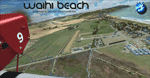
Waihi Beach (ICAO: NZWV) is a small airstrip north of Tauranga and near the small beach settlement of the same name, in the Bay of Plenty of New Zealand. It is a grass strip with offset thresholds giving usable landing lengths of 640m and 517m for RWY 13 and 31 respectively, a width of 55m and a group rating of 5. No night lighting or fuel is available. A very basic airstrip, there is only one recently built hanger and the airstrip is slowly being encroached on by
new housing developments. The airstrip itself is usually very sodden due to its low elevation but is a nice stop over for sightseeing from Tauranga and up the Coromandel peninsula.
The FSX model includes custom textures and models placed on a high resolution aerial image and a 15m mesh. It makes extensive use of items from the free VLC object libraries which are required to be installed (Available from www.vectorlandclass.co.nz Downloads menu). This scenery and
the VLC libraries have been funded by sales of VectorLandClass and although you do not need VLC to use it, your purchase helps further development.
| Filename: | NZWV__Waihi_Beach_Airfield_New_Zealand.zip |
| License: | Freeware, limited distribution |
| Added: | 1st November 2012, 10:01:38 |
| Downloads: | 1,006 |
| Author: | Tim Barnes / VectorLandClass |
| Size: | 11.13 MB |
| Category: X-Plane - Original Aircraft | |
| Piaggio P180 Avanti II |
|
Images related to this file:
File Description:
Features:
-Flight model within 10% of the real aircraft (as per manual);
-Autopilot operations as the real aircraft;
-Many functions and screen indications are SASL driven;
-X-Plane 10 64 bit full compatible;
-Main landing gear object has added (was missing for XP10 in the previous version);
-Electronic checklist in MFD;
-Real clock functions;
-Engine indication turn red when limits exceeded;
-UFMC and X-FMC config files are included. Those files have been adapted specially for this aircraft;
-New 2-page checklist to be printed in a single sheet;
-Updated Operating manual;
-You can use now the condition levers and flap lever by mouse.
PAY ATTENTION:
Use caution when using the throttles! As in the real aircraft, be advancing the throttles too full, torque limits can be exceeded by a lot!
PLEASE: Any questions or problems post them to the forum for this aircraft. I'm visiting it daily so I can respond as quick as possible.
At last, I want to THANK Tony Day, who, with his experience and work, helped me to make this aircraft as real as possible.
| Filename: | Piaggio_P180_Avanti_II.zip |
| License: | Freeware |
| Added: | 24th April 2013, 23:20:42 |
| Downloads: | 631 |
| Author: | Ilias Tselios |
| Size: | 49.42 MB |


© 2001-2026 AVSIM Online
All Rights Reserved
Privacy Policy |