
Where Flight Simulation Enthusiasts Gather from Around the World!
AVSIM Library - Search Results

| Category: Flight Simulator 2004 - Scenery | |
| Big Creek U60 public use airfield in Idaho USA |

|
File Description:
This airfield is in the mountains of Idaho, 30 miles south of Dixie A05, which was the first in the series to be posted. Big Creek is now regularly used for picnic fly-ins and overnight camping, or for just a day of fishing in the creek; the creek does not appear in FS9 as it is not exactly huge, and within the Ultimate Terrain USA settings I have in fact turned streams off as in some cases they cross the grass or (in conjunction with the roads) left insufficient runway space. The U60 runway is at 5,743 feet ASl, 3,550 feet long, aligned 01-19, and in good condition. At the southern end there is the new replica of the old original Big Creek Lodge which was built in 1935. This burned down in 2008, and is now being rebuilt by a group of pilots, pilots having formed a large part of the early clientel courtesy of the grass strip. It is shown here as still under construction. There are also Forest Service buildings on the west side of the runway. All of this is located in the Frank Church Wilderness area and the Payette National Forest. The AI is increased at the weekends, reflecting reality, and also revised to use Boise as one of the starting places. Dixie is also reissued here with a revised positioning to fit with the roads. I had concluded that the roads were wrong, while in fact the position of the airstrip was at fault.
| Filename: | Big_Creek_U60_public_use_airfield_in_Idaho_USA.zip |
| License: | Freeware, limited distribution |
| Added: | 25th May 2017, 17:53:58 |
| Downloads: | 132 |
| Author: | Roger Wensley |
| Size: | 11.06 MB |
| Category: Flight Simulator 2004 - Scenery | |
| Dixie A05 Forest Service airfield in Idaho USA |
|
Images related to this file:
File Description:
This airfield is in the mountains of Idaho, the first in a series. There are not many mountain airfields that can be succesfully modelled in FS9 because the FS9 terrain does not always match reality; no creek for instance, or the valley too small. There are others where the grass strip is all there is, so there is nothing to model apart from resizing the cleared area. Some are well known, well maintained, have clean shower facilities, and are well used for a weekend by small planes with two people and a tent on board, for instance Johnson Creek. Others are less well known but still in good condition, such as Dixie or Big Creek. And there are also some with cabin rental facilities, such as Sulphur Creek Ranch. Other names come to mind, such as Flying B and Pistol Creek, but unfortunately for one reason or another these could not be made. The other difficulty involving hills is succesful AI landings and take offs. At Johnson Creek, for instance, the wind should be from the south to make AI landings more likely to succeed. Dixie is south of the village of the same name, and not to be confused with the dirt strip that is just beside the village. The runway is at 5,148 feet ASL, just over 4,000 feet long and aligned 18-36, and the parking area is at the northern end, opposite the Forest Service buildings. There is a chart of the area included, and to the south of Dixie is the next in the series, Big Creek U60.
| Filename: | Dixie_A05_Forest_Service_airfield_in_Idaho_USA.zip |
| License: | Freeware, limited distribution |
| Added: | 25th May 2017, 17:53:48 |
| Downloads: | 153 |
| Author: | Roger Wensley |
| Size: | 8.69 MB |
| Category: Flight Simulator 2004 - Scenery | |
| CYFD Brantford Municipal Airport, Ontario, Canada Version 1.0 |
|
File Description:
I decided to make Brantford a little more like the real thing. I also changed the landclass in the area to make it more realistic as this is where I live. Here are the changes I have made.
--
Modified the airport in AFCAD2 to have the aircraft park on either side of the large apron as they do in real life
, Corrected the runway lengths and added the connector between the runway ends at the north side of the airport
, Added AI Flightplans (see details below)
, Added a landclass update so that the area appears as it does in real life. There are now more farms around the airport as well as in the Burford area. The towns of Burford (my hometown) and Scotland are added, the Long Point Conservation Authority Forest is added to the west of Burford, and the Burford Golf Links appear beside the 403 (divided highway) to the north west of town.
--AI Flightplans
I tried to make the AI traffic as realistic as possible. I have training aircraft doing touch and goes 7 days a week. A few DC-3's have been restored at the airport so I have a DC-3 that flies for testflights on Monday, Wednesday, and Friday from 7am to 12:30pm. A learjet flies to Chicago on business days. It departs at 8am and arrives at 1:59pm. Also, a 182 flies up to Timmins on the weekends. It departs on Saturday at 9am and arrives home on Sunday at 11:36am.
| Filename: | CYFD_Brantford_Municipal_Airport_Ontario_Canada_Ve.zip |
| License: | Freeware, limited distribution |
| Added: | 9th November 2003, 02:46:05 |
| Downloads: | 2,571 |
| Author: | David Voogd |
| Size: | 425.3 KB |
| Category: Flight Simulator 2004 - Aircraft Repaints, Textures and Modifications | |
| jetBlue Airways Airbus A320-232 Pack |
|
Images related to this file:
File Description:

jetBlue "Tartan Tailfin" (N565JB) - jetBlue "Vets in Blue" (N775JB) - jetBlue "Blue Bravest" (N615JB)
JetBlue Airways Corporation, often stylized as "jetBlue", is an American low-cost airline. The company is headquartered in the Long Island City neighborhood of the New York City borough of Queens. Its main base is John F. Kennedy International Airport, also in Queens.
The airline mainly serves destinations in the United States, along with flights to the Caribbean, The Bahamas, Bermuda, Barbados, Colombia, Costa Rica, Dominican Republic, Jamaica, Mexico and Puerto Rico. As of May 23, 2013 JetBlue serves 78 destinations in 22 states, and twelve countries in the Caribbean, South America and Latin America. jetBlue maintains a corporate office in Cottonwood Heights, Utah. JetBlue is a non-union airline.
Jetblue liveries are painted on Project Airbus A320-232 model (not included). The textures are saved in 32bit format for quality graphics. Textures are also characterized by HD (High Definition). Its features are idle-reverser animation, animated pack vents and pressurisation outflow valve, detailed textures, accurate paint, dynamic shine & effects, dynamic flexing wings that respond to turbulence, fully independent suspension, trim animation, gear steering, accurate flight dynamics, spoiler animation, reflective cockpit windows, improved wingflex code with input from several new parameters including ground spoilers, fuel load, and angle of attack, transparent navigation light lenses and many more.
Visit our Facebook page "Sky Level Textures" for news, updates and previews on our future repaint projects. Thanks for downloading & Happy flying. HD GAMING EXPERIENCE inside. https://www.facebook.com/SkyLevelTextures
| Filename: | jetBlue_Airways_Airbus_A320232_Pack.zip |
| License: | Freeware |
| Added: | 26th November 2014, 22:44:49 |
| Downloads: | 2,222 |
| Author: | Giacomo Tomasini | Sky Level Textures | Project Airbus |
| Size: | 36.66 MB |
| Category: Flight Simulator 2004 - Scenery | |
| Elim ELI and Moses Point MOS in Alaska |
|
Images related to this file:
File Description:
Elim is a coastal village 90 miles east of Nome, living from fishing and with a population of around 330. The airfield has a gravel runway 3,000 feet long. The majority of flights to and from the airfield originate in Nome, but there are also others to and from nearby fields such as Golovin, Unalakleet, Shaktoolik, and Koyuk. A further 7 miles or so east of Elim is another field called Moses Point MOS, which is included here and was an Army Airforce field before being transferred to the private ownership of the Elim Native Corporation. Until Elim ELI was established (date unknown, but after 1988) this served the village of Elim and although the runway is now unlit and not in very good condition (translate that as "full of potholes") it is stated that the longer runway can still be used if Elim is not adequate. However, the note is undated and there are no details of how often it is used or even if it is actually still currently in use. There is one hangar still in existence; all the rest has been demolished and (mostly) removed. A note here about my scenery making. This is post number 502 and there will not be many more to follow this as I am almost at the end of the photos I either took or found for scenery purposes. There is a limit to what can be located online and I have already been making use of the little there is; eg Unalakleet. So, if you are near an airport (preferably Canadian or Alaskan) and have a camera..... Let me know.
| Filename: | Elim_ELI_and_Moses_Point_MOS_in_Alaska.zip |
| License: | Freeware, limited distribution |
| Added: | 2nd August 2019, 16:11:35 |
| Downloads: | 100 |
| Author: | Roger Wensley |
| Size: | 4.69 MB |
| Category: Flight Simulator 2004 - Scenery | |
| Nulato NUL in Alaska |
|
Images related to this file:
File Description:
Nulato is a small village on the west bank of the Yukon River, around 8 miles south of where the river turns from north-south to east-west, east being upstream towards the distant Fairbanks. The population is just under 300 and living from fishing and the land. During the late 1800's the village lived by the spin off from gold mining, such as supplying cut wood as fuel for the boats plying the Yukon River. In 1900 a measles epidemic cut the population down by a third, and in the early 1900's the gold mining moved to Nome and Fairbanks, with obvious results for local prosperity. The airfield is close by and has a gravel runway aligned 2-20 and just under 4,500 feet long. Apart from the airfield itself, and it's buildings, this scenery modifies the local land class, adds village buildings while reducing the village size to reality, and creates a new airfield background. Don't ask me about the odd arrangement of the airfield buildings, I have no idea why they are like that. Nulato is served by Wright Air from Fairbanks in the east and this is included in the AI. A note here about my scenery making. This is post number 508 and there will not be many more to follow this as I am almost at the end of the photos I either took or found for scenery purposes. There is a limit to what can be located online and I have already been making use of the little there is; eg Unalakleet. So, if you are near an airport (preferably Canadian or Alaskan) and have a camera..... Let me know.
| Filename: | Nulato_NUL_in_Alaska.zip |
| License: | Freeware, limited distribution |
| Added: | 25th August 2019, 17:34:25 |
| Downloads: | 103 |
| Author: | Roger Wensley |
| Size: | 3.05 MB |
| Category: Flight Simulator 2004 - Aircraft Repaints, Textures and Modifications | |
| VARIG Boeing 737-341 (PP-VOE) |
|
File Description:
VARIG B.737-341 PP-VOE C/N 24276-1645
Another of the original models B.737-341 builded by Boeing for VARIG(17 exemplaires builded). The 341 is the logic sucessor of the 241, the series 200 model,still in service for some routes. VARIG fleet had differents variant of the Boeing 737'(B.737-2C3Adv,B.737-241,B.737-2K9,B.737-2Q8,B.737-219,B.737-33A,B.737-36N,B.737-3K9,B.737-341,B.737-3Q8,B.737-4YO,etc)and the planes are the workhorse of the route systeme of the airline.The main technical center is located a Rio de Janeiro Antonio
Carlos Jobim(Galeao)with the most big hangar maintenance in South America.
Main hubs are Sao Paulo Guarulhos, Rio de Janeiro A.C.Jobim(Galeao),Porto Alegre Salgado Fihlo.I have included a serie of 90 Flights to the main national and international destinations,all
served with 737 and the timetable and numbers flights are the rights one of this year 2004.
Destinations are revised and actualised like in the reality(Curitiba,Porto Alegre, Ponte aereo=Rio Santos Dumont-Sao Paulo Congonhas,Foz do Iguazú,Manaus,Natal,Recife,Salvador,La Paz,Cordoba,etc.
Many flights are corrected to be acomplished with the 737 and not the Douglas DC-10(out of service by VARIG long time ago and remplaced with the MD-11,this last also to be tasked in the future to fly only cargo).
Today only two DC-10 fly cargo services with VARIG Logistica.
Also included a new complete revised AirFile for the 737-300 type(17-04-04).
| Filename: | VARIG_Boeing_737341_PPVOE.zip |
| License: | Freeware |
| Added: | 17th April 2004, 23:36:37 |
| Downloads: | 572 |
| Author: | Daniel Nole |
| Size: | 464.38 KB |
| Category: Flight Simulator X - Aircraft Repaints, Textures and Modifications | |
| FSX/P3D TWA 707-331Adv 1969 |
|
Images related to this file:
File Description:
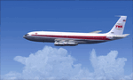
This is a repaint of the 707-300 in TWA 'Star Stream' colors. The payware 707-300 by Captain Sim is needed for this repaint. TWA was one of the two great U.S. intercontinental carriers of the jetliner golden era, the other being PanAm. They plied the world with their shiny 707s, DC-8s, and 747s, well before many other US carriers did so. TWA was also interesting, as it was run by the enigmatic Howard Hughes. On January 25,1959 TWA launched its first jet service on between New York and San Fransisco. The route was chosen by Howard Hughes himself, to compete with American Airlines new jet service between New York and Los Angeles. The plane, a 707-131, sported the new 'Star Stream' double globe livery, one of the most iconic liveries in civil aviation history. TWA carried this livery for almost 20 years, when it was phased out in the late 1970s. This repaint is of a TWA 707-331 Advanced, reg: N18701. It was one of the 127 which went into TWA service in the long history of the airline. It was delivered new in January 1966. Sadly, it was damaged beyond repair in Milan Italy on 22 December 1975, when it landed outside the runway, struck a transmissometer and a CAT II television camera. The landing gear and all 4 engines separated in the subsequent slide. The aircraft came to a rest, with the nose broken off behind the forward cabin door. There were no fatalities. Textures are 32bit DDS. This repaint was tested FSX-SE. It should work on FSX & P3D v1-3.
| Filename: | FSXP3D_TWA_707331Adv_1969.zip |
| License: | Freeware |
| Added: | 27th November 2019, 18:56:40 |
| Downloads: | 173 |
| Author: | Ted Giana |
| Size: | 20.29 MB |
| Category: Flight Simulator 2004 - Aircraft Repaints, Textures and Modifications | |
| Hellenic Air Force, Lockheed F-104 Starfighter |
|
Images related to this file:
File Description:
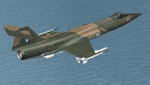
Hellenic Air Force F-104 textures for the ALPHASIM F-104 payware model. The F-104 has gained many 'nick-names' through-out its long career in many air forces around the world. Some of these include 'Widow Maker', 'Manned Missile', and 'Flying Coffin'!
The Hellenic Air Force had a very good track record with this aircraft. Greece originally received 45 F-104Gs and 6 TF-104Gs under the US MAP (Military Assistance Program) in 1964. In 1972 used planes started to be bought with nine more F-104Gs and one TF-104G aircraft acquired from Spain, ten more F-104Gs from the Netherlands in 1982. The largest purchase came when a further thirty eight F-104Gs, twenty two RF-104Gs and twenty TF-104Gs were bought from West Germany. The West German planes were acquired mainly between 1981 and 1988. With one hundred second hand planes, some were mothballed and used as spare parts. Originally flown with just the natural metal finish they eventually were given a camouflage 3 color paint scheme on top of olive drab / dark green / sand, the bottom was a light grey.These planes were flown by two Greek squadrons, the first being 335 Mira from the 114 Pterix (Wing) based at Tanagra AB. The second was 336 Mira, also based at Tanagra AB at the time. December 21st 1966 saw 336 Mira move to a new base at 116 Pterix at Araxos AB.
The F-104 went on in the Hellenic Air Force service until 1993 when 336 "Olympus" Mira Diokseos Bombardismou (Fighter-Bomber Squadron) was deactivated March 31.
| Filename: | Hellenic_Air_Force_Lockheed_F104_Starfighter.zip |
| License: | Freeware |
| Added: | 4th May 2010, 09:49:57 |
| Downloads: | 623 |
| Author: | Leonidas Theofilopoulos |
| Size: | 3.55 MB |
| Category: Flight Simulator 2004 - Scenery | |
| Fort Smith CYSM in Northwest Territories, Canada Revised |
|
Images related to this file:
File Description:
This is an updated version to remove an incomplete static Beaver reported by Graeme (thanks Cobber) and to include other modifications that I made for my own version since posting the original; different taxiway lights, revised aprons, and in particular the revised AI that I mentioned in the original 2011 post. This is complete and can be installed as-is, or used to modify an existing post by changing the original folder contents. Fort Smith is just north of the border between Alberta and Northwestern Territories, midway between Lake Athabasca to the southeast and Great Slave Lake to the north west. You might stop there when flying between Yellowknife or Hay River to La Ronge or Saskatoon. It looks as if it is ex-military and these are the remains of what were once 10,000 feet of asphalt runways. The main runway is now 11/29 and 6,000 feet long, and the secondary one is 1,800 feet of mostly gravel. There is an airline based at the field, Northwestern Air, and fuel is available at a self service point. The town of Fort Smith is two miles east of the airfield, on the bank of the Slave River and where there are some rapids that require a portage to get around them. Before aviation came along the river was a major route to the north and all those furry animals, which was why the Hudson's Bay Company established an outpost there in 1872. Today it has a population of 2,400 and the main activities are government administration of much of the Northwest Territories, education, and tourism.
| Filename: | Fort_Smith_CYSM_in_Northwest_Territories_Canada_Re.zip |
| License: | Freeware, limited distribution |
| Added: | 23rd January 2019, 19:14:44 |
| Downloads: | 143 |
| Author: | Roger Wensley |
| Size: | 7.16 MB |
© 2001-2026 AVSIM Online
All Rights Reserved
Privacy Policy |