
Where Flight Simulation Enthusiasts Gather from Around the World!
AVSIM Library - Search Results

| Category: Flight Simulator 2004 - Aircraft Repaints, Textures and Modifications | |
| VARIG Boeing 737-341 (PP-VOD) |

|
File Description:
VARIG B.737-341 PP-VOD C/N 24275-1637.
The model B.737-341 is the original series 300 builded by Boeing for VARIG(17 exemplaires builded).VARIG fleet had differents variant of the Boeing 737'(B.737-2C3Adv,B.737-241,B.737-2K9,B.737-2Q8,B.737-219,B.737-33A,B.737-36N,B.737-3K9,B.737-341,B.737-3Q8,B.737-4YO,etc)and the planes are the workhorse of the route systeme of the airline.The main technical center is located a Rio de Janeiro Antonio
Carlos Jobim(Galeao)with the most big hangar maintenance in South America.
I have included a serie of 90 Flights to the main national and international destinations,all served with 737 and the timetable and numbers flights are the rights one of this year 2004.
Destinations are revised and actualised like in the reality(Curitiba,Porto Alegre, Ponte aereo=Rio Santos Dumont-Sao Paulo Congonhas,Recife,Salvador,La Paz,Cordoba,etc.
Many flights are corrected to be acomplished with the 737 and not the Douglas DC-10(out of service by VARIG long time ago and remplaced with the MD-11,this last also to be tasked in the future to fly only cargo).
Today only two DC-10 fly cargo services with VARIG Logistica.
Also included a new complete revised AirFile for the 737-300 type(17-04-04).
| Filename: | VARIG_Boeing_737341_PPVOD.zip |
| License: | Freeware |
| Added: | 17th April 2004, 23:36:08 |
| Downloads: | 383 |
| Author: | Daniel Nole |
| Size: | 456.4 KB |
| Category: Flight Simulator 2002 - Scenery | |
| Palisades SRTM Altitude Mesh |
|
File Description:
Ever wanted to fly down the VFR corridor over the Hudson River and gawk at all the skyscrapers in New York City? ... in your dreams! The Department of Fatherland Security has closed it down.
But, we still have Flight Simulator. Unfortunately, the altitude mesh for this area is somewhat lacking in detail.
This Palisades altitude mesh remedies that. Covers the Palisades cliffs, of course (but no Amusement Park, sniff), and also Riverside, Morningside, and Washington Heights, and Fort Tryon. In fact, all 5 Boroughs of New York City are covered, as well as most of central and northern New Jersey (visit beautiful downtown Hoboken!), and the larger part of Long Island. Also Rockland, Westchester, Orange, Putnam counties and more. And even Bear Mountain State Park.
Approximate coverage: N40* to N42* and W73* to W75*.
Made from NASA Shuttle Radar Topography Mission data (3 arc-second resampled to LOD9 - horizontal resolution of 76.4 meters) using SRTM to BGL by Matthew Styles (available in the AvSim library.) Very easy to use - give it a try.
BONUS: includes simple instructions so that anyone can make altitude mesh for their area from SRTM data using SRTM to BGL by Matthew Styles. Sorry, SRTM data only available for the Americas at the moment. The rest of the world coming soon. Check inside for more details.
No support of any kind is offered for this package - very sorry.
| Filename: | Palisades_SRTM_Altitude_Mesh.zip |
| License: | Freeware |
| Added: | 12th June 2003, 16:09:26 |
| Downloads: | 2,165 |
| Author: | Luis, scenery design forum |
| Size: | 3.48 MB |
| Category: Flight Simulator X - Flight Plans | |
| 3 in 1 Panama Fun |
|
File Description:
Three Flights in one Package!!!!.
Flight One......Stratosphere Pirates 1935---
Bill Barnes is called again by the Navy which has been bombarding the "Mystery Island" for 2 days, but
are sure Mordikay has been saved by "The Black Spider" and are now both on their way to Bomb the Panama Canal
in their Marvelous evil Dirigibles!!!!!!!...Bill and you will make a search to Find and Destroy the Derigibles--------Flight II....Lost in the Jungle---
The Motor Club of Talachoochi, Florida have driven from their home town to Panama. (long ride!!!)
Once there they, against the advise of many locals, desided to go to the Darien Jungle, to a place known as
"Blue Snake". This is deep in the jungle near the Colombian border. Roads here are really scarse and very dangerous.
You guessed it............the dudes are now totally lost!!!!!!..............
SAR authorities have been alerted and you must go in your DH to find them. The weather is poor during this time
of the year so the mission is dangerous.-------Flight III.....Holyday to Great Fishing Holes----
The Panama Jungle Yearly Fishing contest is about to start and you have been hired by a bunch of Fishermen from the States, actually 12 of them.
They are to be flown to 3 Hotels in the Jungle where the tournaments will be held. Beware, thunderstorms have been predicted for today!! Have
enough paper bags in the plane!!!..Oh!, one will return back with you.(?)
| Filename: | 3_in_1_Panama_Fun.zip |
| License: | Freeware, limited distribution |
| Added: | 16th February 2008, 09:37:29 |
| Downloads: | 1,290 |
| Author: | Gera Godoy C |
| Size: | 1.2 MB |
| Category: Flight Simulator 2004 - Scenery | |
| Lechfeld, v2 |
|
Images related to this file:
File Description:
This airbase, located about 35 NM in the west of Munich (Bavaria, South Germany),
is the homebase of JaBoG32 riding the Tornado PA200. The German flight check
department GMFS, using C-47 in the early days and thereafter Hawker-Siddeley 748
as well as HS-125 for periodic recalibration of the radar- and navigational
equipment at civil and military airfields, was also on the base till 1994.
After the final decision was made not to establish commercial air traffic although
it had been discussed for a long time period, I reworked the airbase completely.
Among other objects, 38 hardened shelters for combat aircraft have been emplaced.
The included AI-Package contains: Lockheed F-104E GAF, Panavia Tornado PA200 GAF,
Mikoyan MiG-29 GAF, Douglas C-47 GAF, Canberra B.20 GAF, Boeing E3A Nato, Boeing
KC-135 USAF and an aircraft.cfg for the MS Learjet 45.
Several F104's, Tornadoes and MiGs perform touch and goes in the local area,
a Nato E3A leaves IFR to Geilenkirchen (ETNG), an USAF KC-135 routes IFR to
Decimomannu (LIED), a Canberra B.20 (was used for high altitude validations) goes
IFR to Cologne (EDDK) high in the sky and a Learjet shoots IFR to Bremen (EDDW) per
attached flight plan.
Lago's FSE is required in order to see most of the emplaced buildings /objects.
Lets get ready to rumble, but keep in mind, don't argue with the flight checkers
if they are on duty.
| Filename: | Lechfeld_v2.zip |
| License: | Freeware |
| Added: | 12th April 2011, 13:26:46 |
| Downloads: | 1,418 |
| Author: | Klaus Jone |
| Size: | 5.43 MB |
| Category: X-Plane - Original Aircraft | |
| B58 Hustler for X-Plane 6.4/6.51 |
|
File Description:
B58 Hustler v1.0 for X-Plane 6.40/6.51 - development of the B58 began in 1951 with 161 planes delivered to SAC between 1960 and 1970. Americas first supersonic jet bomber (mach 2+) the B58 was designed for high speed delivery of nuclear or conventional weapons from long range as a compliment to the B52 subsonic bomber. One of the most sophisticated planes ever developed, the B58 set many speed and altitude records some of which remain unbroken today. With a gross takeoff weight of 163000 lbs the B58 could cary as much as 101000 lbs of fuel (that's almost 60% of the gross weight). One of the most computerized aircraft ever built, the B58 is amazingly easy to fly without any computer assistance (except the one used to run the x-plane simulator). Go to the attached web sit for the fascinating story of the B58 Hustler.
Wing span: 56 ft. 10 in (17.32 m)
Length: 96 ft. 9 in (29.49 m)
Height: 31 ft. 5 in (9.58 m)
Wing Area: 1,542 sq ft (470 sq m)
Weights:
Empty: 55,560 lb (25,201 kg)
Max T/O: 163,000 lb (73,935 kg)
Performance:
Maximum Speed: 1,321 mph (2,125 km/h) @ 63,150 ft (19,248 m)
Combat Ceiling: 63,150 ft (19,248 m)
Record Ceiling: 85,360 ft (26,017 m)
Combat Radius: 1,750 miles (2,816 km) to,
5,577 miles (8,975 km) with inflight refueling
Powerplant:
Four General Electric J79-GE-1 turbojet engines
rated at 10,500 st. or 16,000 st. with afterburners.
| Filename: | B58_Hustler_for_XPlane_64651.zip |
| License: | Freeware, limited distribution |
| Added: | 1st March 2003, 04:25:26 |
| Downloads: | 708 |
| Author: | Robert App |
| Size: | 1.79 MB |
| Category: Flight Simulator 2004 - Sounds | |
| General Electric CF6-80C2 Complete Sound Suite |
|
Images related to this file:
File Description:

After a long hiatus due to payware obligations and a lack of spare time, I'm back with a bang. Over the course of the last few years or so I have slowly worked on CF6 sounds mainly for personal use. Over time I ended up with something that I knew I just had to share with the Flight Sim community. This is a complete all in one download for all CF6-80C2 powered aircraft. Having spent countless amounts of flights on CF6-80C2 powered A300-600s and 767s I can swear by the authenticity of this work. Additionally I have spent hours on end listening to sound clips and watching videos of CF6 powered aircraft. The quality and accuracy of these sounds will absolutely blow you away! I have included 2 specific soundsets for a wide variety of CF6-80 powered aircraft. One for the CF6-80C2A series that covers the A300-600 and A310 and another for the CF6-80C2B & D series for 767-200ER/300/400, 747-400, MD-11, Air Force 1 & C5 Galaxy M aircraft. All sounds are in full uncompressed Stereo and Mono PCM quality and have been expertly edited, mixed and compiled by myself. You will not encounter distortion or phasing issues, and because of this, these sounds are fully compatible with FSX even without soundcones. Remember, payware doesn't automatically mean better! So turn up the volume and bass and let these sounds immerse you to an all new level!!
| Filename: | General_Electric_CF680C2_Complete_Sound_Suite.zip |
| License: | Freeware, limited distribution |
| Added: | 29th April 2012, 14:14:41 |
| Downloads: | 10,817 |
| Author: | Emil Serafino |
| Size: | 176.22 MB |
| Category: Microsoft Flight Simulator (2020) - Scenery Design | |
| MSFS 2020 object library with 200+ models ranging from towers hangars to cones (v10 12 extra models) |
|
Images related to this file:
File Description:
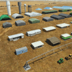
Object libraries for scenery developers (version 10 - improvements on curved surfaces + 10 lights(improved) + 3 windsocks + 3 animals + 5 animated people + 10 fuel_area +stable +fire_tower + 28 new fences + church + sheds). All objects in these libraries will be used in my own sceneries and the result of 100s hrs of effort. All objects from the real world. All objects use LOD (Level Of Detail) to keep frame rates high. Final long distance models have a large triangle added below ground to stop them disappearing in the distance. PBR materials used extensively. Included are 2 PDF files with photos of every object to make selection easy. Republish these files in any freeware scenery if required. READ "read me library instructions" before using.
---------------library1v10-cbj
Cones x4 Gables x3
Church x1
Fences (10 types farm chainlink x4 mesh x2 horse hand-rail paling cattle_grid) x94
Flag pole x1
Fuel_Signs_ x6
Fuel_area_pipes x2
Gas (petrol) station x3
Gliders x4
Glider trailers x4
Grain storage hoppers silos x 4
Power poles x2
Rail platforms station x5
Rail locomotive passenger_carriage grain_hoppers x5
Tower_forest_observation
Towers_radio x6
Weather station small x4
Windsock x3 Windsock-light x1
-------------library2v10-cbj
Animals - Cows x2 Sheep
Grain bunkers - large piles of grain covered with canvas x5
Hangars small airfield x15
Medical transfer station (building) x2
Obstacle-light x10
People x5 Men Women
Pivot irrigator x3
Sheds x10
Shelters x2
Terminals - small airfield x12
Water tanks x3
Towers water x4
Tractors farm x3
Water tanks x3
| Filename: | MSFS_2020_object_library_with_200_models_ranging_f.zip |
| License: | Freeware |
| Added: | 6th March 2022, 19:34:52 |
| Downloads: | 391 |
| Author: | COLIN JEFFERY |
| Size: | 198.25 MB |
| Category: Flight Simulator 2004 - Scenery | |
| Chisasibi CSU2 in northern Quebec, Canada |
|
Images related to this file:
File Description:
Chisasibi is in northern Quebec on the east shore of James Bay, 60 miles from the corner of James Bay and Hudson Bay. Originally called Fort George and founded at the mouth of La Grande Riviere around the Hudson Bay trading post that was established in 1803, the town had to move 5 miles upstream in 1981 when the Quebec hydro project increased the flow rate of the river. The name was changed to Chisasibi at the time of the move (Chisasibi = Great River in Cree) and the population (750 as early as 1940) has now grown to around 2,000. There is a paved road east to Radisson that connects to the north-south James Bay road, which was built at the time of the hydro project work. The original Fort George airport runway is still visible but not usable, just south of the original town site. Chisasibi airport is to the west of the new town, and the gravel runway is 3,792 feet long and aligned 14/32, which is approximately parallel to the river. There is officially no fuel available, but there is JetA on site for Air Creebec in a tank protected by used fuel drums (filled with sand?). The terminal and the garage building are both relatively new; the terminal dates from 2002 and has unusual touches. There are two AI flights by Air Creebec each day plus other private planes.
| Filename: | Chisasibi_CSU2_in_northern_Quebec_Canada.zip |
| License: | Freeware, limited distribution |
| Added: | 27th February 2013, 21:24:47 |
| Downloads: | 287 |
| Author: | Roger Wensley |
| Size: | 2.79 MB |
| Category: Flight Simulator 2004 - Scenery | |
| Sachs Harbour CYSY in Northwest Territories, Canada |
|
Images related to this file:
File Description:
Sachs Harbour is on the southwest coast of Banks Island on the north side of Amundsen Gulf, around 240 miles northeast of Tuktoyaktuk and 180 miles northwest of Ulukhaktok. The village is the only permanent settlement on the island, and is located where it is to benefit from the harbour shelter provided by offshore land. The population is only 130 or so folks, who live on hunting and fishing with some tourism. One claim to fame is that the island is home to threequarters of the world's population of muskoxen and the second is the largest goose colony in North America. The airfield is on the plateau just above the village at 282 feet ASL. The gravel runway 084T/264T (true bearings in Northern Domestic Airspace) is 4,000' long and 100' wide and lit. The apron is on the south side at the centre of the runway and there is a new terminal building; there is JetA fuel available and perhaps 100LL in drums. To the west of the airfield are the deserted buildings of what was once a Department Of Transport weather station. Aklak Airlines flights (operated by Kenn Borek) fly to Sachs Harbour from Inuvik three times a week in summer and twice a week at other times; the AI will be included in the post of a revised Aklavik, and Inuvik revised and Tuktoyaktuk should be fully installed BEFORE Sachs Harbour.
| Filename: | Sachs_Harbour_CYSY_in_Northwest_Territories_Canada.zip |
| License: | Freeware, limited distribution |
| Added: | 14th May 2012, 17:20:09 |
| Downloads: | 394 |
| Author: | Roger Wensley |
| Size: | 6.16 MB |
| Category: Flight Simulator 2004 - Scenery | |
| St. George (KSGU) / Mesquite (67L), Utah/Nevada, Photo-Scenery (FS9 & FSX) |
|
Images related to this file:
File Description:
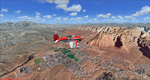
Covers the area between St. George, Utah and Mesquite, Nevada. To the north of St. George
the Pine Valley Mountains with their foothills of scenic red sandstone loom over the city.
St. George Municipal Airport (KSGU) is mostly used for general aviation but is also served by SkyWest Airlines
on behalf of Delta Connection. Because of it's location on a mesa this airport can't be expanded and so a new
airport is currently being built southeast of the city at the site of an abandoned airfield. The opening
is expected in 2011. To the south of the city make sure, you don't miss the Virgin River Gorge where the
Virgin River winds thru a long winding canyon in the transition zone between the red rocks of southern Utahs
Colorado Plateau and Nevadas Mojave Desert. Shortly afterwards you reach Mesquite which is situated just
west of the Arizona stateline. Like nearly all Nevada cities near the stateline Mesquite is home to several
Casinos. Mesquite Airport (67L) lies just north of the city.
High resolution versions of this scenery for FS9 and FSX (much sharper, but larger and multiple downloads)
are available at www.blueskyscenery.com/CNY_South3West6.html . The screenies are taken from the high-res versions,
so expect this version to be slightly more blurry. Thanks to Joop Mak for providing custom AFCADs that
correct airport layouts so that they align with the photo-textures! They are available at www.blueskyscenery.com/AFCADs.html .
YourDonation@Work: Dedicated to Werner, Ralf-Peter and Nels.
| Filename: | St_George_KSGU__Mesquite_67L_UtahNevada_PhotoScene.zip |
| License: | Freeware, limited distribution |
| Added: | 24th March 2010, 19:41:43 |
| Downloads: | 1,652 |
| Author: | Gottfried Razek - blueskyscenery.com |
| Size: | 95.58 MB |
© 2001-2026 AVSIM Online
All Rights Reserved
Privacy Policy |