
Where Flight Simulation Enthusiasts Gather from Around the World!
AVSIM Library - Search Results

| Category: Flight Simulator 2004 - Scenery | |
| TNCS - Juancho E. Yrausquin Airport - Saba, Netherlands Antilles |

|
Images related to this file:
File Description:
This island is the smallest municipality of the Netherlands. Saba is just under 30 miles south of St. Maarten, the island that was split between France and the Netherlands; to the southeast and 20 miles away is the small island of St. Eustatius, then St Kitts and then Nevis. The island comes out of the water like the top of Everest and keeps going, and there is no large space for a runway and no possibility of creating one with landfill with those steep sea cliffs. So what you have is a small runway (aligned 12/30) of 1,000 feet plus over-runs at each end that have small "closed" markings (see the white crosses) for a usable total of around 1,300 feet.
The airport restricts access as there is only space for four planes to park, plus a helicopter. And of course there is also the short runway to contend with. Landings are carried out under waivers issued by the Netherlands Civil Aviation Authority, and will always be on runway 12 as the southeast trade winds predominate. Twotters land there but only in real life; FS9 AI Twotters don't seem to find it adequate. There is no fuel or any other facility except for a small terminal building and a car park.
| Filename: | TNCS__Juancho_E_Yrausquin_Airport__Saba_Netherland.zip |
| License: | Freeware, limited distribution |
| Added: | 8th May 2013, 02:52:26 |
| Downloads: | 1,495 |
| Author: | Roger Wensley |
| Size: | 3.09 MB |
| Category: Flight Simulator X - AFCAD Files | |
| LFRV Meucon-Vannes |
|
File Description:
Vannes-Meucon Airport is a regional airport in France (IATA: VNE, ICAO: LFRV). It supports general aviation with no commercial airline service scheduled.
Summary of Changes:
Realigned runway 9/27 to runway 8/26 (as it is in real life). Note that in FSX although this runway is not closed, ATC will never assign this runway, as it is a grass strip, and ATC prefers the asphalt 4/22 instead. IRL 4/22 is actually 3/21 but I couldn't realign this runway, as it has a localiser approach which can't be removed or moved in ADE
Added taxiways B+D to allow traffic to taxi to/from the end of runway 22 via runway 8/26 without causing pileups. Whilst not completely accurate, its very close.
Added fuel trucks to top end of apron, (on the charts this area is designated as a hangar, I chose not to include this, as the FSX hangars look rubbish) Note that only 1 fuel truck moves at a time.
Added a few extra parking spaces. I dislike the method of using every free space for parking, so I have only included parking where LFRV really has designated parking. The airport now has 11 GA parking spaces small-medium.
| Filename: | LFRV_MeuconVannes.zip |
| License: | Freeware, limited distribution |
| Added: | 20th November 2011, 00:26:06 |
| Downloads: | 326 |
| Author: | Martin Joy |
| Size: | 5.89 KB |
| Category: Flight Simulator X - AFCAD Files | |
| MTPP - Toussaint Louverture International Airport / Port-au-Prince, Haiti |
|
Images related to this file:
File Description:
MTPP - Toussaint Louverture International Airport / Port-au-Prince, Haiti
This airport update was made with the latest version of ADE (Airport Design Editor) and made for FSX as a replacement for the stock (default) airport. I found that most stock airports in FSX lack a decent amount of character and realism and this area in particular was dreadful! The stock airport was rather inaccurate. I've made several additions to the airport which are listed below. All these enchancements are as close to the real airport as I can get with stock library objects. I've used satellite images, terminal photos and maps throughout the whole process so building locations are as accurate as possible. Happy landings in Haiti!
Features:
*Expanded parking apron
*Seperate parking aprons for GA traffic
*Main terminal building with its 3 jetways
*Cargo area
*Hangars and other airport buildings added
*Airport vehicles and objects throughout the airport
*Corrected runway length and numbering
*Corrected taxiway signs
*Birds near the airport
*More ships and smaller fishing vessels added to the Port-au-Prince bay
*Fishing marina added in the bay
*Main road in front of airport added with static vehicles
*Parking lots with static vehicles
*Vegetation in front of airport
| Filename: | MTPP__Toussaint_Louverture_International_Airport__.zip |
| License: | Freeware |
| Added: | 15th July 2012, 06:44:51 |
| Downloads: | 1,164 |
| Author: | Jaison Diaz |
| Size: | 10.19 KB |
| Category: Flight Simulator 2004 - Aircraft Repaints, Textures and Modifications | |
| Roman Abramovich Private Boeing 767-33A/ER (P4-MES) |
|
Images related to this file:
File Description:
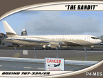
I am proud to present this SkySpirit 2010 V5 model of the Boeing 767-33A/ER owned by billionaire Roman Abramovich. This aircraft bears the Aruban registration P4-MES, and was nicknamed "The Bandit" because of the mask painted around the cockpit windows. This is one of the largest aircraft owned and used by a private individual. It is operated for its owner by Global Jet Luxembourg, callsign "Silver Arrows." This livery is quite elegant and understated for such a "go big" owner. Although flight plans for this aircraft are hard to come by as its registration is blocked when in flight, it makes regular, frequent appearances in Innsbruck (LOWI) and St. Maarten (TNCM). It also shows up at many destinations outside Russia including; Stansted(EGSS), Vienna (LOWW) and Zurich (LSZH). In case you are curious, Roman Abramovich himself is in the captain's seat on this repaint. I tried to make this repaint as accurate as possible. However, the satellite system on the real P4-MES is not representable on this model. The repainted textures in this package are 32-bit with no mipmaps for best clarity and quality. This is a complete install. This package contains SkySpirit2010 B767-300 V5 model, air and config files. The sound is from the default 737.
| Filename: | Roman_Abramovich_Private_Boeing_76733AER_P4MES.zip |
| License: | Freeware, limited distribution |
| Added: | 4th October 2011, 05:20:16 |
| Downloads: | 1,583 |
| Author: | Jeffrey S. Bryner, SkySpirit2010 |
| Size: | 12.33 MB |
| Category: Flight Simulator X - Scenery | |
| Carrier CVN75_V2 North Sea |
|
File Description:
This is a update version of my scenery DL_CVN75.zip.
Changes in Version 2 of the cenery:
1.The Carrier model is now a private object and no longer part of the standard FSX object lib..
This allows the installation and registration in FSX scenery setting to be done like any
other addon objects.
The registration of the scenery in FSX below " Global, Generic & Vehicle Libraries" is no
longer required !!!!
2.Version 2 has more stuff on deck of the carrier.
3.The Number 75 is more accurate according to the real carrier.
4.The ILS frequencies ( e.g. GS) is more accurat adjusted in relation to the cable zone.
Scenery: Carrier Group North sea. Close to the Island of Sylt The Scenery includes: - The USS Carrier Harry Truman, CVN 75 with full function as an Airport with ILS approach capability.
F18-Fighters and a Navy-Heli on the Carrier. - 2 flying Helicopters over the Carrier. - 4 Navy-Destroyers escorting the Carrier. In addition to the Carrier-Group: - A Oilrig about 30 nm northwest from the Carrier. The Heli-Pat is a landable Platform !! - 2 moving Destroyer based on a "Boats Traffic Plan" which are moving around the group according to the time schedule in the plan.
| Filename: | Carrier_CVN75_V2__North_Sea.zip |
| License: | Freeware |
| Added: | 26th December 2008, 10:44:37 |
| Downloads: | 3,485 |
| Author: | Dietmar Loleit |
| Size: | 4.83 MB |
| Category: Flight Simulator X - Scenery | |
| VNLK-LUKLA-FSX |
|
File Description:
well it starts as always, i can't find any usable freeware airport in this case for
the VNLK - Lukla Airport so I'll build it myself again...............
well what can i say here it is after a lot of work as real as possible with a lot of
details with the Default scenery built ..........
starts from Kathmandu as in the original with a propeller plane or a transport
heli and brings the climbers and adventurers to the Himalaya Mountains.........
Installation:
copy the folder VNLK-Lukla Scenery into the addon folder of the FSX, start the
FSX Settings, change scenery library , add area, press OK , after that you can
already start............
Extras:
to be able to see people I deliver the file 3DPeoble_Lib with you can
also put it in the Copy the addon folder and activate it in FSX as described
during installation and you'll see you people..............
the same applies to EZ-Scenery-Object files for extra buildings! ( Lukla building )
! Danger ! You don't need these files if you already have them. !
There is a video about my airport on Youtube https://youtu.be/uffenHkCKao
Support:
Questions and help on my Youtube channel
https://www.youtube.com/channel/UC7vHXQMa3hhU2iGtODXlkHw
or by email to [email protected]
And now have fun learning to land under difficult conditions.....
| Filename: | VNLKLUKLAFSX.zip |
| License: | Freeware |
| Added: | 8th April 2023, 01:34:00 |
| Downloads: | 448 |
| Author: | Wagner Ewald alias Jamaika |
| Size: | 76.72 MB |
| Category: Flight Simulator 2004 - Scenery | |
| PAAT (ATU) - Attu - Alaska, USA |
|
Images related to this file:
File Description:
Attu is AT the western end of the Aleutian chain of islands in Alaska, around 40 miles west of Shemya. There was small village on Attu before the Japanese invasion in mid 1942, but the island is now uninhabited. The Coast Guard Loran navigation station remains in place, though it is no longer in operation and visitors to the island are now either tourists or wildlife experts conducting surveys of numbers of nesting birds, etc. The runway still usable is aligned 02-20 and 5,800 feet long; right hand circuits on 02 to stay away from rising ground to the west. The "terminal" building has lost its sign regarding the Horny Bird, removed in 2010 by one of the last of the station operators, but the building is still there, as are some sheds and shacks that lately were used for the uncomfortable accommodation of bird counters. FS9 has used an incorrect icao identification for Attu but correcting it now would make life complicated so ATU it is and shall remain. I have removed the default FS9 roads that came complete with streetlights and telephone poles and replaced and amended the layout with gravel roads to better resemble real life, though the island shape is at best approximate, as is usual in FS9.
| Filename: | PAAT_ATU__Attu__Alaska_USA.zip |
| License: | Freeware, limited distribution |
| Added: | 2nd March 2015, 20:58:09 |
| Downloads: | 280 |
| Author: | Roger Wensley |
| Size: | 3.27 MB |
| Category: Flight Simulator 2004 - Scenery | |
| Mackenzie River close to Tulita CZFN in Northwest Territories Canada |
|
Images related to this file:
File Description:
I discovered, while testing another airfield near the Mackenzie River, that along the side of the Mackenzie adjacent to Tulita, and for a considerable distance, there was a cliff of water. I have no idea if my version of Ultimate Terrain has developed a fault or if this has been caused by the installation of a terrain mesh that now argues with UT for some unknown reason. Whatever, it was impossible to leave it as it was. I have included a screenshot of the cliff further upstream. To avoid the cliff of water I have flattened that area of the Mackenzie River and the adjacent river banks and both the town and the airfield to a height above sea level of 400 feet. This does not reflect the real life situation but is the lesser of two optical evils. I have included a screenshot of the flattened area. If you do not have a problem then you do not need this. If you too have a cliff of water then you might want to try this. It does not completely get rid of the problem, but it does get rid of it in the area visible when landing or taking off at Tulita.
| Filename: | Mackenzie_River_close_to_Tulita_CZFN_in_Northwest_.zip |
| License: | Freeware, limited distribution |
| Added: | 1st August 2021, 22:27:01 |
| Downloads: | 75 |
| Author: | Roger Wensley |
| Size: | 573.48 KB |
| Category: Flight Simulator 2004 - Scenery | |
| VGEG Chittagong/Shah Amanat International, Bangladesh |
|
Images related to this file:
File Description:

Googly scenery for VGEG Chittagong/Shah Amanat International (known as M A
Hannan until 2005) - an important airport in Bangladesh that is poorly provided
for in Flight Simulator 2004. These scenery files add taxiways, aprons,
buildings and other airport features, including the military area at the north
end and the general aviation ramps, so that you and your "AI" traffic can land,
taxi, park and take off in a realistic manner.
The city of Chittagong and its port are served regularly by jets ranging in size
from the Fokker 28 to the Douglas DC10 from operators like Air Arabia, Air Asia,
Biman Bangladesh Airlines, Oman Air, Thai Airways International, and turboprops of
GMG Airlines, United Airways and Zoom Airways.
The scenery does not purport to be ultra-accurate. Based on high-detail satellite
imagery from Google Earth, the layout is proportionally correct but the added
airport features, such as buildings, are built from default Microsoft objects
and add-on libraries so will not look like the real thing.
You are not obliged to download and install any additional scenery libraries,
but to enjoy this scenery in its entirety, you may wish to. It will work fine,
with or without.
[File re-uploaded at request of AVSIM]
| Filename: | VGEG_ChittagongShah_Amanat_International_Banglades.zip |
| License: | Freeware |
| Added: | 14th May 2010, 05:10:02 |
| Downloads: | 3,079 |
| Author: | John Hinson |
| Size: | 71.7 KB |
| Category: Flight Simulator 2004 - Scenery | |
| VGCB Cox's Bazar, Bangladesh |
|
File Description:
Googly scenery for VGCB Cox's Bazar, Bangladesh, a small domestic airport
serving the fishing town of the same name in the Bay of Bengal, to the
south of Chittagong. It boasts extensive sandy beaches which has allowed
tourism development. The unusual name comes from Captain Hiram Cox of the
British East India Company who was appointed Superintendent of the outpost
in the late 1700s. The airport, which was originally a Pakistan Air Force
base, sees domestic flights (mostly to/from Dhaka) operated by Hawker
Siddeley 748s, de Havilland Dash 8s and Fokker Fellowship aircraft of Biman
Bangladesh Airlines, GMG Airlines, United Airways and Zoom Airlines.
Flight Simulator 2004 has made no provision for traffic with only a runway
provided and this scenery seeks to redress the situation.
The scenery does not purport to be ultra-accurate. Based on high quality
satellite imagery from Google Earth, the layout is proportionally correct but the
added airport features, such as buildings, are built from default Microsoft objects
and add-on libraries so will not look exactly like the real thing.
You are not obliged to download and install any additional scenery libraries,
but to enjoy this scenery in its entirety, you may wish to. It will work fine,
with or without.
| Filename: | VGCB_Coxs_Bazar_Bangladesh.zip |
| License: | Freeware |
| Added: | 14th April 2008, 21:13:08 |
| Downloads: | 1,352 |
| Author: | John Hinson |
| Size: | 67.71 KB |


© 2001-2026 AVSIM Online
All Rights Reserved
Privacy Policy |