
Where Flight Simulation Enthusiasts Gather from Around the World!
AVSIM Library - Search Results

| Category: Flight Simulator X - Scenery | |
| RAF Polebrook |

|
File Description:
On June 28, 1942, RAF Polebrook was officially turned over to the USAAF and the airbase became the base of the 97th Bombardment Group, the first USAAF heavy bomber organization to arrive in the UK. It was designated USAAF Station 110.
The 97th BG was assigned to the 1st Combat Wing, at RAF Bassingbourn. It's operational squadrons were divided between Polebrook and RAF Grafton Underwood:
340th Bomb Squadron (RAF Polebrook)
341st Bomb Squadron (RAF Polebrook)
The 97th BG conducted a total of 14 missions from Polebrook, attacking airfields, marshalling yards, industries, naval installations, and other targets in France and the Low Countries.
The group sortied 247 aircraft, dropped 395 tons of bombs on Nazi-controlled territory, and lost 14 aircraft. On October 21, 1942, the 97th Bomb Group was transferred to the Twelfth Air Force in the Mediterranean theater and Polebrook was unoccupied until April 1943.
351st Bombardment Group (Heavy)
On April 15, 1943, the 351st Bomb Group arrived at RAF Polebrook. It was assigned to the 94th Combat Wing, also at Polebrook. The group tail code was a "Triangle J". It's operational squadrons were:
508th Bomb Squadron (YB)
509th Bomb Squadron (RQ)
510th Bomb Squadron (TU)
511th Bomb Squadron (DS)
Boeing B-17G-85-BO Flying Fortress, Serial 43-38465 of the 510th Bomb Squadron. This aircraft survived the war and returned to USA on 8 June 1945
Douglas-Long Beach B-17G-30-DL Flying Fortress Serial 43-38116 of the 509th Bomb Squadron.The 351st's first completed combat mission took place on May 14, 1943, when 18 B-17's targeted a German Luftwaffe airfield at Kortrijk, Belgium. As the war progressed, the 351st operated primarily against strategic objectives in Germany, striking such targets as ball-bearing plants at Schweinfurt, communications at Mayen, marshalling yards at Koblenz, a locomotive and tank factory at Hannover, industries at Berlin, bridges at Cologne, an armaments factory at Mannheim, and oil refineries at Hamburg.This is for FSX and you will need to have Ted Andrews's RAF Hangars Library and his other great RAF Buildings. They can
be found on AVSIM. Search the FSX section for "Ted Andrews" - you'll find loads of his scenery object files for
RAF airfields. Follow his instructions on how to install them.
| Filename: | RAF_Polebrook.zip |
| License: | Freeware |
| Added: | 21st January 2009, 13:27:45 |
| Downloads: | 1,058 |
| Author: | Scott Berge |
| Size: | 15.01 KB |
| Category: Flight Simulator 2004 - Scenery | |
| Anticosti Island in Quebec Canada |
|
Images related to this file:
File Description:
Anticosti Island is in the Gulf of St Lawrence, around 25 miles off the Quebec mainland coast. It is some 40 miles wide and 130 miles long on an east west axis. There are few urban areas and only one that can be described as a small town, namely Port Menier at the western end of the southern coast, with a population of under 1,000. There is a ferry service to the harbour.
The airport, Port Menier CYPN, is around 3 miles northeast of the town, with an asphalt runway aligned 11-28, 4,875 feet long and 150 feet wide with PAPI at each end. In 2010 (the approximate date of this scenery) a gravel runway was still visible at the eastern end of the field. This was no longer in use by 2010, except perhaps by small planes on skis in the winter.
The island, with its small population, small urban area, and no industry other than logging, has as a result a mainly undisturbed wildlife population. This has made deer hunting and fishing the main tourist activities, with one company (called Safari) having an exclusive licence to exploit large areas of mountains and rivers. Planeloads of hunters and fishermen are flown in on chartered Nolinor Aviation planes, landing at CYPN. There are a further two airfields in the eastern end of the island, and in 2010 Rivere-Aux-Saumons CTH7 had a 5,500 feet gravel runway, linked by road to a lodge area at the mouth of the river. This is the only lodge area that I have been able to locate, but there are others. To the south Riviere Bell CRB5 had at that time a gravel runway that was 3,000 feet long. This has been lengthened since then and both runways were recently (2021) asphalted.
If you find an error email me please, and note that my email address has been changed to rogwens at Gmail dot com. The reason I am posting this now is that I discovered that my original post ended up in MSFS Original Aircraft instead of in FS2004 Scenery. Ooops!
| Filename: | Anticosti_Island_in_Quebec_Canada.zip |
| License: | Freeware, limited distribution |
| Added: | 28th January 2022, 17:39:46 |
| Downloads: | 121 |
| Author: | Roger Wensley |
| Size: | 11.78 MB |
| Category: Flight Simulator X - Original Aircraft | |
| Airbus A318 FD Special Version V3 - Light Pack |
|
Images related to this file:
File Description:

This is the new version of my Airbus A318 with the Panel in V3 opened on the A321 - here in a light pack version, included is 1 livery only (Frontier Airlines NR807 Painted by Derek Mayer & Steve Mac Bee of PA Team).
This light pack contains only the user manual in english version (and low resolution). If you want the french version of this manual, use the "zipdrive" function with the complete pack of this aircraft (search by name file "pa318fd_v3.zip"). This light version has been made by request for all those with low download speeds and limits.
The original complete pack is available HERE (filename: pa318fd_v3.zip)
I remind you that this aircraft is based on the Project Airbus A318, with an ehanced panel based on the work of stefan Liebe.
This latest development can see the more realistic Airbus available as freeware. With a new version of the panel, the aircraft has a 100% cold & dark Status at the start of a flight, a real fuel system management with all valves, piumps and crossfeed work, the complete Bleed circuit with X-bleed, a real engines manual startup procedure like the real aircraft. I have also ehanced the navigation display with TCAS function in ARC and NAV mode; There is also the engines failure procedure to work (fire, oil leaks....) and many improved function that I cannot describe here. The aircraft comes with user manual in English and in French, and it is essantial to read it before you fly.
All the functions of the V2 have been kept and improved, like the vertical navigation gauge, the terrain radar map on the navigation display, the autolanding function, the SFCC.
This version is only in CFm engines, but with real engine data (CFM56-5B9) and custom HD sounds. Now, the Fly By wire works in 2 modes: "Normal Law" and "Direct Law". I put 300 hours into the development of this panel and I hope that you will like it.
Please, note that this panel is the v3.05 version, witch fixes the bugs of the first version that came with the A321 (there is an update panel for the A321).
So, It seems that this aircraft works with PREPAR3D
Francois Dore
| Filename: | Airbus_A318_FD_Special_Version_V3__Light_Pack.zip |
| License: | Freeware, limited distribution |
| Added: | 14th July 2012, 15:34:06 |
| Downloads: | 6,725 |
| Author: | Francois Dore, Project Airbus |
| Size: | 64.88 MB |
| Category: Flight Simulator 2004 - Scenery | |
| CYKF - Kitchener, Regional Muni of Waterloo - Ontario Canada |
|
Images related to this file:
File Description:
The town of Kitchener is in southern Ontario, 40 miles southwest of Toronto. The population is just over half a million, including the adjoining Cambridge and Waterloo which are known locally as the Tri Cities. The Kitchener name was adopted in 1916, replacing the former "City of Berlin".
The airport is on the northeastern side of the town, with the main runway aligned 08-26 and just over 7,000 feet of asphalt 150 feet wide, lit, with PAPI at both ends and approach lighting and ILS on 26. The second runway is aligned 14-32 and is 4,100 feet long, lit and with PAPI at both ends; right hand circuits for 32. The airport is being steadily enlarged and improved, with new hangars for rental, operators, and maintenance companies. The largest and most visible presence is the training operation located just off the southwest end of taxiway A, where there are 14 Cessna 172, 2 Cessna 152, 2 Piper Seminole, and others. These are represented in the AI. There are morning and evening scheduled flights by Westjet to Calgary and American Eagle to Chicago, also in the AI. To the southwest, past taxiway C, there is GA parking; request taxi to what is named here "southwest parking" where there are spaces on both grass and asphalt. To the southeast, along a taxiway off the southeast corner of the main apron, are mainly operators and maintenance facilities. This version of CYKF includes the new(ish) terminal, the first of the new central rental hangars alongside the new taxiway and access road, and the very new large hangar off taxiway C, but not the new airport services building (fire and snow clearance) that is off to the southeast of taxiway A, and not the new car park to the south of the airport access road. So an uncertain and possibly historically innacurate date, but with the correct taxiway lighting and signage, and building textures from photographs.
| Filename: | CYKF__Kitchener_Regional_Muni_of_Waterloo__Ontario.zip |
| License: | Freeware, limited distribution |
| Added: | 7th May 2016, 21:13:28 |
| Downloads: | 547 |
| Author: | Roger Wensley |
| Size: | 28.69 MB |
| Category: Flight Simulator 2004 - Scenery | |
| PAKN - King Salmon - Alaska, US V1 |
|
Images related to this file:
File Description:
This is the final version, complete in itself and incorporating the two modifications posted separately. King Salmon is a town with a population of just under 400, on the north bank of the Naknek River and 15 miles from the sea. The airport is adjacent to the town and was originally an airforce base; the military hangars on the airport are still usable. The airport, with its long runway (11-29 and 8,500 feet with an ILS, and a second runway 18-36 and 4,000 feet) is a transportation hub for the area in general and in particular for the salmon industry. Along the Naknek River there are numerous canneries and there are also fishing lodges on the river and nearby lakes; to speed up transportation to the lodges there are float bases on the river to the south of the airport. King Salmon has three tiers of scheduled flights: Alaska Air direct from Anchorage in a 737 (passengers and cargo), PenAir (Saab turboprop) as part of their flights up and down the peninsula, and Grant Air serving nearby small towns. There are also PenAir flights, both scheduled and unscheduled, in smaller aircraft (Piper Navajo for instance) to smaller airports for the fishing season, plus cargo flights in larger aircraft by the lowest bidder (Everts and Northern). To complete the mix the AI includes a pair of F15s. The runways cross (see the airport diagram) so read the notes re long taxi routes. There is AI for PAKN, plus revised AI made for Dutch Harbor which includes flights by PenAir to King Salmon, plus revised parking for Dutch Harbor with new replacement bgls to cater for more flights. There is also AI for the float bases on the river; I have made two runways separated into two float bases for river AI, called King Salmon Floats and King Salmon River; more AI for these will be added when other scenery along the river is made. Just land according to the wind and taxi to whatever dock takes your fancy.
| Filename: | PAKN__King_Salmon__Alaska_US_V1.zip |
| License: | Freeware, limited distribution |
| Added: | 11th April 2015, 06:20:40 |
| Downloads: | 502 |
| Author: | Roger Wensley |
| Size: | 23.67 MB |
| Category: Flight Simulator X - AFCAD Files | |
| Essex County Airport (KCDW), NJ |
|
File Description:
Located 02 miles N of Caldwell, New Jersey on 275 acres of land, Essex County Airport is a public airport with two asphalt runways, the longest of which is 4552'. Major changes include Runway 9/27 updated to the current 10/28; Runway 4/22 markings are custom made to match the real world, with threshold stripes on Runway 22 only; the beacon has been relocated to its real world location atop the control tower. Additionally, 221 parking locations have been accurately placed around the airport, broken up into 6 sections. See the included airport diagram that labels the various parking areas. 89 of these parking spaces are labeled RAMP_GA and these spaces are occupied by static aircraft. Collision with all static aircraft is disabled but still, if you do not want to start occupying the same space as another airplane, do not choose parking spots labeled RAMP_GA. Instead, all user aircraft should choose either RAMP_GA_SMALL (for wingspans up to 40') or RAMP_GA_MEDIUM (for wingspans up to 60' and only available in East Parking). Also, only 86 of these parking spaces are available for AI aircraft to spawn in. There are hangars available to transient aircraft: the two in South and Southeast parking are able to accommodate small craft with wingspans up to 40'; the one in Northeast parking is able to accommodate larger aircraft with wingspans up to 54'. Helicopters can start either on Taxiway P (South helipad), Taxiway N (North helipad) or in front of the main terminal (East helipad). Fuel is available in both the East and South parking areas by stopping anywhere on the concrete next to the fuel tank/pump. Take note that the runway patterns are both Left and Right and the pattern altitude varies for aircraft type. There are known issues with the AI for this airport, see the ReadMe for more details.
Scenery constructed with use of satellite images/streetview/aerial photos - the author has not been there in person.
This scenery is meant to be used in conjunction with MegaScenery Earth New York 005. It is not required, but apron use is minimized to allow satellite scenery to show through as much as possible, and objects are placed based on the MSE textures - lack of it may make scenery look out of place.
| Filename: | Essex_County_Airport_KCDW_NJ.zip |
| License: | Freeware |
| Added: | 14th April 2011, 01:50:13 |
| Downloads: | 416 |
| Author: | Drew Sikora |
| Size: | 2.4 MB |
| Category: Flight Simulator X - Aircraft Repaints, Textures and Modifications | |
| North American B-25J (PH-XXV) "Sarinah" |
|
Images related to this file:
File Description:
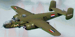
This folder contains a repaint for the North American B-25 by Roy Chaffin Studios (RCS). It shows B-25J PH-XXV "Sarinah" of the Royal Netherlands AF Historical Flight. The B-25J-20-NC SN 44-29507 now flying as "Sarinah" was accepted by the USAAF on September 28, 1944 and delivered on September 30, 1944. She departed the same day to Moody Field, Georgia. The TB-25J trainer-bomber came on duty with 2144 Base Unit, ATC starting October 7, 1944. During her Air Force career, she amassed nearly 6200 flight hours. In July of 1959, she was sold to Fogle Aircraft in Tucson, Arizona. Her civil registration was assigned as N3698G at that time. In November of 1959 she was sold to Aero Enterprises in Elkhart, Indiana. In March of 1962 she was sold to Verco Tropical Fisheries in Columbus, Ohio. She was converted to carry cargo in bomb bay and waist area in December of 1962. She was then sold in February of 1966 to Robert R. Johnson from Ft. Lauderdale, Florida. In November 1968, she was owned by Austin Williams. Sold again in July 1972 to Ernest G. Trapaga from Redondo Beach, California. In September of 1974 she was purchased by I. N. Burchinal of Paris, Texas. Then, in September of 1979 she was sold to Robert Wingate, then back to Burchinal in November who sold her to Reyline Aviation from Kissimmee, Florida. In June 1981 she was sold to Donald Webber of Baton Rouge, Louisiana. She flew as "Cochise". In December of 1989 she was sold to AMHO Corp from Wilmington Delaware and the registration was changed (in 1990) to N320SQ (representing the Dutch B-25 Mitchell 320 squadron). She was then ferried to Eindhoven, the Netherlands May 22-25 1990. The bomber was operated by the Duke of Brabant Air Force (DBAF) at Eindhoven Airport, Netherlands, who owned the bomber since 1996. From 1990 to 1999 she flew in RAF colors as "Lotys II". In April-May 1999 she was repainted in former ML-KNIL (NEIAF) colors and renamed "Sarinah". In 2009, her civil registration was changed to the current PH-XXV. Ownership was transferred in 2010 to the Royal Netherlands AF Historical Flight after a merger with DBAF. Repaint by Jan Kees Blom, based on the original textures by RCS.
| Filename: | North_American_B25J_PHXXV_Sarinah.zip |
| License: | Freeware |
| Added: | 25th August 2019, 17:33:20 |
| Downloads: | 122 |
| Author: | Jan Kees Blom |
| Size: | 2.5 MB |
| Category: Flight Simulator 2002 - Gauges | |
| Reality XP 737-500 ADI True Display XP Unlocked Demo |
|
File Description:
Not to be redistributed in any form without prior approval from Reality XP
Reality XP 737 ADI in True Display XP Demo Important information
This is the readme for the fully unlocked version 1.1
Dear Flight Simulator Enthusiast, we thank you for flying with Flight Line Avionics, and are pleased to offer an example of our unique technology: True Display XP.
As you might have been aware off, we are currently designing the overall systems and avionics of the upcoming Flight1’s Piper Meridian. This extraordinary aircraft features an advanced cockpit panel, with Glass Cockpit Meggitt Avionics EADI, EHSI and EDU, coupled with a state of the art S-TEC Autopilot System and a full featured Garmin Radio Stack and Navigation System. Rest assured that our rendition of the Meridian avionics far above the standards of the Flight Line Avionics depth and accuracy, and even more!
To let you prefigure what our unique technology brings to the overall simulated experience, we have especially designed this 737 ADI Demo to showcase a small fraction of the overall design techniques and tools we have built: True Display XP.
True Display XP is meant to provide enough visual cues and precision, while not sacrificing the accuracy at any resolution. This is achieved with both a high refresh rate and a highly sophisticated rendering engine, while virtually having no impact to the FS2002 Frame Rate. With this technology in any aircraft product, you’ll be able to precisely hand fly any ILS approach to a level of precision you’ve never been used to with any other FS2002 add-on. Seeing is believing!
Unlike the other “vector gauges”, our unique technology not only resembles and feels like a real CRT/LCD, but is more elaborate than an Anti Aliasing Line Drawing system. This prevent any “jitter” in effectively rendering all the display at a sub pixel resolution.
We are glad to let you share our excitement for the Flight1’s Meridian with this demo which showcases our unique technology.
We thank you for your fidelity to Reality XP.
Best Regards,
Reality XP
www.reality-xp.com
| Filename: | Reality_XP_737500_ADI_True_Display_XP_Unlocked_Dem.zip |
| License: | Freeware, limited distribution |
| Added: | 11th December 2002, 00:53:03 |
| Downloads: | 4,030 |
| Author: | Reality XP |
| Size: | 361.33 KB |
| Category: X-Plane - Original Aircraft | |
| Spruce Goose for X-Plane 6.4/6.51 (hk-1/H-4 Hercules) |
|
File Description:
Spruce Goose v1.0 for X-Plane copyright (c) by Robert App, January 2003. History of the "Goose" - Officially designated the HK-1 (this project started out as a join venture between Hughes Aircraft and Kaiser) and later designated the H-4 Hercules after Kaiser was unable to work with Howard. It was and still remains the largest (physical dimensions wingspan and length) aircraft ever built, with the largest radial engines ever built by the West (28 cylinder, 3000 HP). The plane had to be constructed mainly of wood due to the shortage of strategic metals caused by WWII. The plane became known as the "Spruce Goose" or "Flying Lumberyard" despite the fact that the wood frame and skin were constructed mainly of laminated poplar; it also involved "sandwich" construction. The plane was flown briefly on a trial taxiing run but Hughes never allowed the plane to be flown again. Speculation has always been rampant that the design was flawed and the plane could not have met the original specification requirements. The X-Plane model is as accurate as is possible with limited plans available to me. The main wing is an X-Plane standard symmetrical high lift airfoil as opposed to the high lift asymmetrical foil section used in the actual plane. The main wing angle of attack has been adjusted to emulate the asymmetrical foil as closely as possible.
Flight Testing the Goose - I have spent many hours testing the plane on X-Plane which with few exceptions provides a very accurate flight model. The published landing speed (79 mph) pretty well verifies the takeoff speed of 52 to 55 knots (k/hr x 1.15 (approx.) = mph). In straight flight the plane is difficult to stall since the nose quickly drops and increases speed if a stall develops with a significant loss of altitude. The plane has a range on 14000 gallons of fuel and takeoff weight of 350,000 Lbs of well over 3000 nautical miles. San Diego to Wake Island via Midway Attol is a piece of cake with lots of fuel to spare at 350,000 lb GW. The plane is flyable at a GW of over 410,000 lb but climb rate is very sluggish (max 400-600 fpm) and loss of speed due to excessive side slip can cause a fatal stall, in straight flight the plane is difficult to stall. So far my conclusion is that with todays materials and jet engines (which may be a future project) this aircraft could probably be competitive in performance with todays planes. With aluminum alloys that were available during its construction its performance would probably have exceeded the initial requirements.
| Filename: | Spruce_Goose_for_XPlane_64651_hk1H4_Hercules.zip |
| License: | Freeware, limited distribution |
| Added: | 31st January 2003, 05:19:19 |
| Downloads: | 1,739 |
| Author: | Robert App |
| Size: | 1.69 MB |
| Category: Flight Simulator 2004 - Scenery | |
| Chicoutimi / St-Honore CYRC in Quebec Canada |
|
Images related to this file:
File Description:
This is the third of five sceneries around Lac Saint-Jean in Quebec, Canada. Saint-Honore is a village on a crossroads 32 miles east of the lake, and the airport, called Chicoutimi in the Nav Canada Flight Supplement, is a mile or so east of the village. It is of the familiar triangular military design with three runways 12-30, 06-24, and 18-36. Of these, the longest is 12-30 at over 6,000 feet and has approach lighting and glide slope indicators. Of the other two 06-24 is now closed, but this scenery is based on the 2010 situation with all three open. There are two apron areas, one just to the south of 12-30 and a second to the northwest of 06-24 and served by a separate taxiway. The largest operator is a training establishment based on the northern apron and with a sizeable fleet of Beechcraft trainers (Skipper) that does not exist as an FS9 plane, so these are represented by a similar stand-in substitute. There is also a helicopter emergency evacuation operation to the east of the large control tower, and other hangars. The south apron has two main companies, Max Aviation and Exact Air, both of which run local regular scheduled flights in the area (though both appear to have now subcontracted these out to other companies) and also engage in training and charter flights. There is also a parachute training company. The ai includes flights by the companies on the field and also GA. The list of AI planes is explained in the AI folder, with details of downloads etc. The fleet of training aircraft is one of the planes in the revised (by Nick Tselepides) Piper Aircraft, designed for AI Traffic by Andras Neumann with a Paintkit by Charles Dayhuff adapted by Graham Eccleston, and Paints by Graham Eccleston, Andras Neuman and Frank Cooper along with the trainer repaint by Nick Tselepides. The Max and Exact aircraft textures are approximations by me; apologies. The use of the runways also as taxiways complicates the AI on runway 12-30 as directed by ATC. The AI will always leave 12-30 by the earliest exit, which means that the fleet of trainers will exit to the southern apron but will then taxi back onto the runway to reach taxiway A or runway 36 (according to wind direction) to proceed to the northern apron. In real life they land long and then taxi straight to the end of the runway to reach taxiway A or runway 36 without using the south apron at all. There is no way to correct this so just be ready to go around.
| Filename: | Chicoutimi__StHonore_CYRC_in_Quebec_Canada.zip |
| License: | Freeware, limited distribution |
| Added: | 12th November 2017, 17:35:21 |
| Downloads: | 342 |
| Author: | Roger Wensley |
| Size: | 29.03 MB |
© 2001-2026 AVSIM Online
All Rights Reserved
Privacy Policy |