
Where Flight Simulation Enthusiasts Gather from Around the World!
AVSIM Library - Search Results

| Category: Flight Simulator 2004 - Aircraft Repaints, Textures and Modifications | |
| Boeing B-17G 'Rhapsody in Red' |

|
File Description:
This is a repaint (textures only) for the Donationware B-17G Late from FighterTown Design Group. You can get it here for a great price!! www.donationware.net
Thank you FDG for providing this great plane!!
Special thanks go to Jarink, who is a repainter in IL-2/PF. Jarink was kind enough to send me his layered photoshop files of the Noseart that I used for these repaints. I also used his repaints as a guide for my repaints.
This texture represents "Rhapsody in Red" one of the B-17G Flying Fortresses of the 91st Bomb Group, 8th Air Force. The 91th BG, one of the more famous groups in the Eighth Air Force. "The Ragged Irregulars" were based at Bassingbourn, England.
"Rhapsody in Red" Crew Members:1st Lt. Frank L. Adams, Pilot (0763887); 1st Lt. Monte B. Adams, Co-Pilot (0556018); 1st Lt. Harold W. Burts, Bombardier (0772936); 1st Lt. Elmer Gettis, Navigator (0712554). T/Sgt. Clifford M. Schultz, Radio Operator (36744080); T/Sgt. Vivian R. Chowning, Jr., Engineer (33634254); S/Sgt. Gerald L. Block, Waist Gunner (13085771); S/Sgt. Seymour B. Gold, Tail Gunner (32966976); S/Sgt. Joseph F. Sovina, Waist Gunner (33607095); S/Sgt. Roy Bertrand, Ball Turret Gunner (38488949). Rhapsody in Red completed 94 missions. Mr. Schultz believes that the members of this crew may have completed 35 missions. Her last sortie was also the 91st Bomb Group's last sortie on April 25, 1945. She returned to the U.S.A. on May 26, 1945. On November 28, 1945 she was sent to Kingman, Arizona.
| Filename: | Boeing_B17G_Rhapsody_in_Red.zip |
| License: | Freeware |
| Added: | 29th August 2006, 22:11:03 |
| Downloads: | 133 |
| Author: | Brian Hill, FDG |
| Size: | 4.37 MB |
| Category: Flight Simulator X - Aircraft Repaints, Textures and Modifications | |
| P-51D Mustang "Frenesi" (N357FG) |
|
Images related to this file:
File Description:
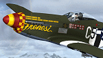
This is a repaint for the payware Warbirdsim P-51D "Mustang Tales" product. This repaint depicts the latest Mustang restoration to emerge from Midwest Aero Restorations, completely stock, which just had its first test flight from Danville, Illinois on January 30th. The aircraft is F-6K 44-12852 (restored as a P-51D), owned/operated by Dan Friedkin/Comanche Fighters, based in Texas. Sold surplus immediately following WWII, registered as NX66111, the aircraft was entered into the 1946 Cleveland Air Races as racer #80 "Full House", but its engine blew and was forced to crash-land. Later, the aircraft was sold to Jack Hardwick in the early 50's and crudely rebuilt, with a jump seat and rudimentary dual controls installed in the back of the cockpit, and would soon be sold onto the Dominican Air Force in 1954, becoming FAD 1900 (#2). The aircraft served with the Dominican AF until it was sold and imported back into the US by Brian O'Farrell in 1984. Made serviceable, the aircraft flew again on the US register as N21023 by 1990, and was sold to Jim Beasley Sr. and later owned/operated by Jim Beasley Jr., of Coatesville, PA (sharing hangar space with their P-51D "Bald Eagle"). During this time the aircraft was painted as "Frenesi", the personal mount of WWII 357th Fighter Group ace Gen. Tommy Hayes (the name inspired from a 1940 Artie Shaw tune). By the early 2000's, showing the effects of poor-quality work done on repairing/restoring the aircraft in the past, a complete rebuild of the airframe began. By 2009, the project was sold to Dan Friedkin, now registered as N357FG, and the restoration was continued at Midwest Aero Restorations, known for their award-winning authentic Mustang rebuilds. The aircraft has now emerged in early 2017, resplendent and flying again in the markings of "Frenesi".
| Filename: | P51D_Mustang_Frenesi_N357FG.zip |
| License: | Freeware |
| Added: | 5th February 2017, 19:56:49 |
| Downloads: | 84 |
| Author: | John Terrell |
| Size: | 24.84 MB |
| Category: Flight Simulator 2004 - Miscellaneous Files | |
| The World Tour |
|
Images related to this file:
File Description:
01) https://youtu.be/36ZpHnGq7a4
02) https://youtu.be/vFImsajMgLc
03) https://youtu.be/X_FfupH_-MU
04) https://youtu.be/oU6ypwHF6ik
05) https://youtu.be/qz_-HPTv2oo
06) https://youtu.be/Qnbnwi_UAwk
07) https://youtu.be/qeS94k8_hkE
08) https://youtu.be/Rz93YNRQbvw
09) https://youtu.be/BlisZXwgG3Q
10) https://youtu.be/jwor56LaRb4
11) https://youtu.be/IkbSk6z2bfw
12) https://youtu.be/2u8jqtNQxyM
13) https://youtu.be/8qx8R_zCfQ0
14) https://youtu.be/j5kiDHzTBH8
15) https://youtu.be/6z1mLJ-Ne6M
16) https://youtu.be/6sypz9ljSXQ
17) https://youtu.be/_rw5LwjfsmQ
18) https://youtu.be/cp0kDNPjxLc
19) https://youtu.be/eMB7uzHBgeE
20) https://youtu.be/0ohUqRADcjU
21) https://youtu.be/y2PNB0w9SEE
22) https://youtu.be/YHqzjlB8xoo
23) https://youtu.be/bMpS536hPDc
24) https://youtu.be/edd7OmU1674
25) https://youtu.be/vsnCD_dUbEk
26) https://youtu.be/iGR9LkmZ6iI
27) https://youtu.be/G4MeInVKUII
28) https://youtu.be/5RtNJ5N2OuE
29) https://youtu.be/3Ob42QNz6uk
30) https://youtu.be/bdmgdFnADVQ
31) https://youtu.be/uRxygmvyRS8
32) https://youtu.be/mSH-Hh2ShIw
33) https://youtu.be/1HjKTsvub2Y
34) https://youtu.be/An-MndXznow
35) https://youtu.be/aT-Y69R9XeI
36) https://youtu.be/kXwDY1AiIKM
37) https://youtu.be/7VwxMboQCAI
38) https://youtu.be/yFfNxZdcQ6w
39) https://youtu.be/KyRHD9WWpb4
40) https://youtu.be/0zbj7IsSva8
41) https://youtu.be/Z81ixHuSUJE
42) https://youtu.be/rxS0BsyVy8Q
43) https://youtu.be/-9AeEfNRG9c
44) https://youtu.be/hAq9jOC6wFM
45) https://youtu.be/-HuzxYh2cao
46) https://youtu.be/eCngRAujuB4
47) https://youtu.be/_DL0rOV6li0
48) https://youtu.be/DgM4e_bS0uY
49) https://youtu.be/MD0K_VAGtWA
50) https://youtu.be/x6-rHHgb5As

This is only an Utility, to fly a tour of the world in 50 steps. It was Built for FS9, it has not been tested for other simulators (FSX, etc). For presentation, suggestions and other see enclosed file The World Tour.pdf. Contents: 50 flight plans, with FLT, WX and PLN files for each plan and Krakatoa scenery with a fictional scenery of Krakatoa volcano. Enjoy your flights
| Filename: | The_World_Tour.zip |
| License: | Freeware |
| Added: | 29th November 2016, 15:07:29 |
| Downloads: | 231 |
| Author: | Aldo Della Vedova |
| Size: | 35.66 MB |
| Category: Flight Simulator 2004 - Scenery | |
| Fort St James CYJM in British Columbia Canada |
|
Images related to this file:
File Description:
Fort St James is a small town of around 1,600 folks at the southeastern end of Stuart Lake, at the head of the Stuart River, and around 360 miles north of Vancouver and 220 miles inland from the coast. It was a long-established trading post for furs, with a permanent presence there from 1806 onwards. The airfield is 3 miles south of the town and is called "Fort St James (Perison)" in the Nav Canada listings. I presume that this is part of their trend towards calling airfields by their location rather than by their name. Makes sense as it is difficult to find information by searching for an airfield that is listed under a name you don't know. The field has an asphalt runway of 4,000 feet aligned 10-28 and at 2,364 feet ASL. There is no lighting. The main user of the airfield is Interior Helicopters Ltd. who are based there as operators, and at Williams Lake as helicopter dealers. For the AI helicopters, there is a screenshot (01) of the AS350 helicopter installation folder when it has been transformed into an AI helicopter. The process is to download and install the Ecuriel AS 350, along with the additional textures, as normal; this is straightforward. Then you download the software shown in screenshot 02 and add it as instructed and as shown in 01 so that the helicopter now operates as AI, with a different air file and a modified config file. I should have included this with the Pemberton post. I have posted this as Fort St James CYJM, but I suggest that you just add it to your previously created "BC airfields" and avoid the inevitable doubling up of common textures etc. Up to you. If you find a defect, email me.
| Filename: | Fort_St_James_CYJM_in_British_Columbia_Canada.zip |
| License: | Freeware, limited distribution |
| Added: | 23rd November 2020, 20:14:04 |
| Downloads: | 150 |
| Author: | Roger Wensley |
| Size: | 2.62 MB |
| Category: Flight Simulator 2004 - AI Aircraft | |
| AI Gliders |
|
File Description:
This packages is the result of my efforts to get AI-glider traffic into FS2004.
Included are:
-a fictional glider-airfield (my personal area51) somewhere at a quiet and flat place at Denmark. It's divided into two afcads AF2_A51A.bgl and AF2_A51B.bgl;
-an AI-version of the DUO DISCUS, tweaked in a way that it takes off from the airfield (afcad A51A), fly a pattern and land at the same airfield (afcad A51B). After 30 minutes the glider does the same trick from afcad B to afcad A. And so on every hour;
- an other AI-version of the DUO DISCUS, tweaked in a way that it will take off from afcad A, climb while circling and then keeps endlessly circling at an altitude of around 3000ft ASL in the surrounding of the airfield; A second glider of the same sort takes off from afcad B and also start circling endlessly.
- an traffic.bgl to make the above flights possible (and the source files for it).
You can use this package as an example to make your own AI-glider-airfields and AI-glider_trafficfiles. It is my intention to upload other AI-gliders in a short time.
Credits go to Wolfgang Piper for his excellent gliders which inspired me to start experimenting with AI-gliders and for giving me permission to rebuild his gliders to AI-versions.
For other examples of his excellent gliders, visit his site http://www.fsglider.de
Also credits go to Alan Kaiser for the stemme.air, which I used to make the AI-versions for the DUO DISCUS.
| Filename: | AI_Gliders.zip |
| License: | Freeware, limited distribution |
| Added: | 27th June 2005, 23:22:45 |
| Downloads: | 2,345 |
| Author: | Bert de Bruin |
| Size: | 1.82 MB |
| Category: Flight Simulator X - Scenery | |
| RAF Tholthorpe |
|
File Description:
RAF Tholthorpe opened in the late 1930s as a grass airfield, and operated as a sub-station of RAF Linton-on-Ouse.
From August 1940 to December 1940, Tholthorpe was a landing field for Whitley bombers of No. 58 Squadron RAF and No. 51 Squadron RAF based at Linton. From January 1941 to June 1943, Tholthorpe underwent maintenance to upgrade to Class A standards, with three intersecting concrete runways.
RAF Tholthorpe was assigned to No. 6 Group RCAF in June 1943. RCAF squadrons stationed here included No. 434 Squadron "Bluenose", 431 Squadron "Iroquois", 420 Squadron "Snowy Owl", and 425 Squadron "Alouette".
No. 434 Squadron, flying Halifax bombers, was formed and headquartered at Tholthorpe airfield from June 1943 until the squadron was moved to Croft. In July 1943, 431 Squadron moved to Tholthorpe airfield from Burn. It was later moved to Croft airfield as well. Not only were the operational squadrons quartered here, also their service echelons, - respectively Nos. 9431 and 9434 Service Echelon - which were formed from the ground crew of nos. 431 and 434 Squadron on 3 November 1943 and who moved with their squadrons on to Croft in December 1943.
In December 1943 No. 420 and No. 425 Squadrons (together with their service echelons, nos. 9420 and 9425 Service Echelon were moved to Tholthorpe airfield from Dalton and Dishforth respectively. These squadrons had returned from service with Wellingtons in North Africa, and it took them several weeks to work up on the newly acquired Halifax bombers. They were therefore unable to fly their first raids from Tholthorpe until mid-February 1944.
No. 420 Squadron flew 160 operations from Tholthorpe airfield and lost 25 Halifax’s. No. 425 squadron flew 162 operations from Tholthorpe airfield and lost 28 Halifax’s. In all, 119 Halifax bombers were lost from Tholthorpe. In April and May 1945 nos. 420 and 425 Squadron converted to Avro Lancaster’s, which they took with them when they left for RCAF Debert, Nova Scotia, Canada in June 1945.
The station closed in June 1945.
| Filename: | RAF_Tholthorpe.zip |
| License: | Freeware |
| Added: | 9th May 2017, 20:41:48 |
| Downloads: | 138 |
| Author: | Terry Boissel |
| Size: | 4.63 MB |
| Category: Flight Simulator X - Aircraft Repaints, Textures and Modifications | |
| FSX/P3Dv3 Alisarda F-27-200 1973 |
|
Images related to this file:
File Description:

This is a repaint of the F-27-200 in Alisarda colors. The freeware FSX Native with VC F-27-200 by Bjorn Kesten is needed for this repaint. It was converted from Mike Stone's and Tom Gibson's models. The textures are 32bit DDS. It was tested on FSX-SE, but should work on FSX & P3Dv3.
Alisarda was an Italian airline based at Olbia, in Sardinia. It was established on March 28, 1963 as an air taxi company registered under the official name Linee Aerea della Sardegna SpA. Their first aircaft were two Beech 18s and Alisarda only provided a charter service. However, one year later,in 1964, they opened their fist scheduled service from Olbia to Rome. 1965 proved to be a pivotal year for the carrier. A reorganization was carried out whereby an agreement was concluded with Algenova for technical and commercial support. New investors were found, and in February 1965 two new Nord 262s were ordered from Nord Aviation. Due to this greater transport capacity, the transport figures increased strongly and in 1966 a total of 5,640 passengers were transported. The passenger loads increased dramatically in 1968 and 1969, so, Alisarda purchased three F-27 Friendships to take up the extra loads. The airline entered the 1970s with strength, and in January 1974 they received their first pure jets with the purchase of two DC-9-14s from Delta Airlines, I-SARJ and the I-SARV. 1977 saw them purchase two DC-9-32s, followed by three DC-9-50s in 1983, which replaced the aging DC-9-14s. In 1984 they received two new Maddog 82s. Their route network by 1989 consisted of domestic flights to many cities in Italy, plus international routes to Zurich, Geneva, Munich, Frankfurt, Paris, and Nice. In 1991 Alisarda merged with the Spanish carrier Universair, as the shareholders wanted to become a bigger players on the European market. The new carrier was named Meridiana. Thus, the name Alisarda ceased to exist.
| Filename: | FSXP3Dv3_Alisarda_F27200_1973.zip |
| License: | Freeware |
| Added: | 21st January 2020, 17:49:09 |
| Downloads: | 80 |
| Author: | Ted Giana |
| Size: | 4.79 MB |
| Category: Miscellaneous Files - Demos from Commercial Vendors | |
| Latin VFR Cuzco Photo and Airport Scenery |
|
File Description:
Cuzco or how is also formally known today as “Cusco” is one of the most important cities of Peru and is the historic capital of the Inca empire, it is also the historical capital of Peru designated by its constitution. The city is located in the Andes mountains and its elevation is above 3310 metres or 10860 feet above sea level. The city is nearby the ancient historical symbol of the Incas, Machu Picchu which is about 80 kilometers from Cusco, which became one of the New seven wonders of the world back in 2007.
This airport (SPZO) or (CUZ) has a visibility restriction and only operates during daylight due to the requirement of a visual approach to land. The aircraft operate mainly in one direction of flight in and out of this airport, they land on runway 28 and depart on runway 10. During weather situations in which no visual approach can be made the airport is closed until the weather gets better. No pilot dares to land with an overcast sky into an airport completely surrounded by mountains and no precision guidance navaid in order to assist for the landing. Therefore all landings conducted are SOLELY visual, and strict VFR rules apply. American Airlines (AA) briefly operated in this airport in the late 90’s and the word out there was that they kept doing miss approaches having difficulties with the approach, so it is widely known to be an airport dominated by veterans of the Cuzco approach, mainly Peruvian pilots or Andean pilots that know how difficult it is to have such restrictions. This is certainly the Madeira or the Innsbruck of all Latin American airports, it would be wise to say that this one is harder due to the lack of a precision approach. And by the way the largest aircraft permitted to operate here is a B757-200, however, anything bigger than a B737-200 needs government approval.
| Filename: | Latin_VFR_Cuzco_Photo_and_Airport_Scenery.zip |
| License: | Commercial demo |
| Added: | 2nd May 2009, 01:50:57 |
| Downloads: | 1,200 |
| Author: | LatinVFR |
| Size: | 34.22 MB |
| Category: Flight Simulator 2004 - Scenery | |
| Anticosti Island in Quebec Canada |
|
Images related to this file:
File Description:
Anticosti Island is in the Gulf of St Lawrence, around 25 miles off the Quebec mainland coast. It is some 40 miles wide and 130 miles long on an east west axis. There are few urban areas and only one that can be described as a small town, namely Port Menier at the western end of the southern coast, with a population of under 1,000. There is a ferry service to the harbour. The airport, Port Menier CYPN, is around 3 miles northeast of the town, with an asphalt runway aligned 11-28, 4,875 feet long and 150 feet wide with PAPI at each end. In 2010 (the approximate date of this scenery) a gravel runway was still visible at the eastern end of the field. This was no longer in use by 2010, except perhaps by small planes on skis in the winter. The island, with its small population, small urban area, and no industry other than logging, has as a result a mainly undisturbed wildlife population. This has made deer hunting and fishing the main tourist activities, with one company (called Safari) having an exclusive licence to exploit large areas of mountains and rivers. Planeloads of hunters and fishermen are flown in on chartered Nolinor Aviation planes from the south. There are a further two airfields in the eastern end of the island, and in 2010 Rivere-Aux-Saumons CTH7 had a 5,500 feet gravel runway, linked by road to a lodge area at the mouth of the river. This is the only lodge area that I have been able to locate, but there are others. To the south Riviere Bell CRB5 had at that time a gravel runway that was 3,000 feet long. This has been lengthened since then and both runways were recently (2021) asphalted. If you find an error email me please, and note that my email address has been changed to rogwens at Gmail dot com.
| Filename: | Anticosti_Island_in_Quebec_Canada.zip |
| License: | Freeware, limited distribution |
| Added: | 31st July 2021, 18:23:40 |
| Downloads: | 80 |
| Author: | Roger Wensley |
| Size: | 11.78 MB |
| Category: Flight Simulator 2004 - Scenery | |
| Lake Athabasca Airfields in Alberta & Saskatchewan Canada |
|
Images related to this file:
File Description:
These are four airfields around or near Lake Athabasca, in Alberta and Saskatchewan. Fort Chipewyan CYPY is at the southwestern end of the lake and the direct recipient of pollution that flows north from the Tar Sands to the south. The population of around 850 lives in one of the earliest European settlements in Alberta, founded as a trading post by Peter Pond of the Northwest Company in 1788 and named for the Chipewyan people who lived in the area. The airfield has one runway aligned 03-21 and 5,000 feet of asphalt, with PAPI at both ends. The landclass has been modified along with the grassed area of the airfield to create the village on the lakeshore. There are scheduled flights and GA flights in the AI for all four airfields. Charlot River CJP9 is on the northern shore at the western end of the lake, in Saskatchewan. It serves a nearby hydroelectric project and is used to transport technical staff in and out. There is no terminal building, only waiting pickup trucks and a generator building. There is one lit gravel runway aligned 04-22 and just over 3,200 feet long. Fond-du-Lac CZFD is on the northern shore in Saskatchewan, at the narrower eastern end. The population is around 900 and is a remotely situated "fly-in" village that has existed for over 150 years where "living off the land" is an accepted and normal way of life. The village has been created along with the airfield. The single runway is 3,800 feet of lit gravel aligned 10-28 with PAPI at the western end. Stony Rapids CYSF is east of the end of Lake Athabasca, on the Fond du Lac River. It has a population of around 250 and is only semi-connected to the rest of Canada by a rough gravel road. The runway is over 5,000 feet of gravel, aligned 06-24 with PAPI at both ends. The NorthSKlake is a flatten for an Ultimate Terrain lake that was at an incorrect elevation.
| Filename: | Lake_Athabasca_Airfields_in_Alberta__Saskatchewan_.zip |
| License: | Freeware, limited distribution |
| Added: | 7th August 2018, 12:39:52 |
| Downloads: | 175 |
| Author: | Roger Wensley |
| Size: | 20.36 MB |
© 2001-2026 AVSIM Online
All Rights Reserved
Privacy Policy |