
Where Flight Simulation Enthusiasts Gather from Around the World!
AVSIM Library - Search Results

| Category: Flight Simulator 2004 - Scenery | |
| Carp CYRP updated, near Ottawa in Ontario Canada |

|
Images related to this file:
File Description:
This version updates the post of 2006 with specifically modelled buildings for the east apron, plus a new AFCAD file. This is a stand-alone version and does not require you to have downloaded and installed the previous post. Carp airfield is fifteen miles west of Ottawa and two miles south of the town of Carp. There are two runways, 10/28 which is asphalt and almost 4,000 feet long and 100 feet wide, and 04/22 which is gravel and 2,000 feet long. The airfield has a fairly large polulation of general aviation residents and two years ago was expanding under new ownership, with a new terminal building and a large hangar opened and the "Touch'n Go" aviation warehouse that has opened more recently. The first version of Carp really included only the west apron, as that is where all (or almost all) the general aviation is located. I "represented" the east apron buildings without modelling any of them. This version corrects that, and the modeled east apron buildings are the HQ of Helicopter Transport Services Inc. and the adjacent Bell Helicopter service hangar, and the old First Air hangar and offices which are now under new ownership. The smaller hangars on the other side of the apron belong to chapter 245 of the Experimental Aircraft Association.
| Filename: | Carp_CYRP_updated_near_Ottawa_in_Ontario_Canada.zip |
| License: | Freeware, limited distribution |
| Added: | 16th February 2010, 03:18:39 |
| Downloads: | 562 |
| Author: | Roger Wensley |
| Size: | 6.03 MB |
| Category: Flight Simulator 2004 - AFCAD Files | |
| KORD - Chicago O'Hare - Chicago, USA - Runway 10C / 28C |
|
File Description:
This is the second of my two KORD AFCADs, the first for FSX and this one for FS9. Both add the newly opened runway 10C-28C and change the old runway10-28 to runway10L-28R. In this one, as in the FSX version. I use completely default objects, so no additional downloads of scenery are required. All Taxiways have been correctly identified using ADE9X and taxiway signs placed to reflect the ground situation as of the 1311 AIRAC Cycle that ends Nov 14, 2013. I added RNAV and CATIII ILS/DME approaches for both Rwy 10C and Rwy 28C you can select in the default GPS. In the default FS9 file for KORD runway 32L, which still exists, is given as an ILS/DME approach using 108.95, the same frequency as the new runway 10C-28C. I could not delete the ILS/DME for 32L (cannot delete stock navaids in FS9). It interfered with the CAT III ILS/DME for 10C-28C, so I simply changed the ILS frequency for 32L to the same frequency as for 14R. Please note further that in the 1311 AIRNAV supplement for KORD there are no approaches listed for 32L, so I deleted all approaches for 32L, but the waypoints for those approches remain in place (since they are stock navaids and, hence, cannot be deleted).
| Filename: | KORD__Chicago_OHare__Chicago_USA__Runway_10C__28C.zip |
| License: | Freeware |
| Added: | 13th November 2013, 22:03:13 |
| Downloads: | 766 |
| Author: | Randy Tyndall |
| Size: | 60.25 KB |
| Category: Flight Simulator 2004 - Aircraft Repaints, Textures and Modifications | |
| Lockheed L-749A Constellation TWA 1958 |
|
File Description:
FS2004 Lockheed L-749A Constellation TWA 1958.
In June 1939 TWA (Transcontinental & Western Air) required a four-engined airliner capable of flying transcontinental US services non stop west to east or with one stop travelling in the opposite direction against the prevailing wind. The specification was drawn up by TWA's major shareholder Howard Hughes and TWA-director Jack Frye. The intial result was the L-49 Constellation, but before the first aircraft was built WWII broke out and the Connie was drafted by the militaries as C-69. After the war the C-69 was renamed L-049 Constellation and delivered to a.o. TWA (27). The L-649 and L-749 Constellations were the first true civil versions. TWA used 12 L-749's and 28 L-749A's from March 1948 till 1967. This particular L-749A, N6001C 'Star of New Jersey', flew with TWA from 24 March 1950 till September 1966. It was scrapped in 1968.
This repaint is a much improved version of the one issued in 2006. It has not been tested for the FSX version of Abacus' Constallation but probably will function there as well.
These are textures only. You will require Francisco Sánchez-Castañer's great payware Lockheed L-749 Constellation, which can be obtained from Abacus' Platinum Collection (see http://www.abacuspub.com/default.html). Repaint (based on Francisco Sánchez-Castañer's textures) by Maarten Brouwer.
| Filename: | Lockheed_L749A_Constellation_TWA_1958.zip |
| License: | Freeware, limited distribution |
| Added: | 14th September 2007, 18:25:40 |
| Downloads: | 521 |
| Author: | Maarten Brouwer |
| Size: | 3.31 MB |
| Category: Flight Simulator X - Flight Plans | |
| Wrong Way Charlie |
|
File Description:
Charlie Hungsfinger Took off from KaraKose in Eastern Turkey in his
Yellow Piper Cub happy to fly his 87 take off in his Eastern Europe
VFR tour.After a great 400 ft high, mountain hopping flight he desided to land in
a little town he saw at his 3 O´clock to get some water something to eat and
directions for he knew he was lost. He called the tower at Karakose and told them of his intentions.
Two hours later Charlie was behind bars in an Iranian Army base....With a possible
International Incident about to happen!!!!!!
-----
A special Forces Team based in the Turkish Air Force Base of Van has been ordered
to get Charlie out of his prison as soon as possible...No
need for an Internatinal Incident due to Charlie´s "wrong way tour"!!!...
The Mission calls for an air drop near the army base, there will be 6 Special forces
dudes and their STALWART!!..Charlie, if gotten out will be driven back to the
border since it is to dangerous to land a plane at the Iranian Base!!! or near it.. No Way!!!
A very dangerous mission indeed!...on Four engines, a Stealth Fighter, 8 Wheels and tough boots!!!
| Filename: | Wrong_Way_Charlie.zip |
| License: | Freeware, limited distribution |
| Added: | 29th August 2007, 03:27:22 |
| Downloads: | 700 |
| Author: | Gera Godoy C |
| Size: | 298.66 KB |
| Category: Flight Simulator 2004 - Scenery | |
| Montana Unleashed! - Part One |
|
Images related to this file:
File Description:
Montana Unleashed! Part 1 is the first in a two part series of a collection of airports in Montana. The majority of airports covered in Part 1 are located in the western half of the state. THIS IS A RE-UPLOAD OF A PREVIOUS UPLOADED SCENERY THAT WAS LOST DURING THE AVSIM HACK! NOTHING HAS CHANGED!
Montana Unleashed! is a collection of 14 highly detailed airports, created using Abacus' EZ-Scenery, scattered about the state of Montana and one in Washington. Do a ZipDive and check out some of the screenshots! The state of Montana, from what I've seen, seems to have been very neglected by scenery makers over the years which is surprising considering the beautiful and varied landscapes the state has to offer. There's some very cool approaches at many of these airports. The size of the airports vary from large all the way down to small county airports meaning you can fly just about any kind and size of aircraft with these sceneries. Fly your Delta 737 from Salt Lake to Bozeman. Fly your shiny new Skywest EMB-120 from Missoula to Billings. Or fly your Piper Cub from Havre City to Choteau and on to Dillon. It's all here!
| Filename: | Montana_Unleashed__Part_One.zip |
| License: | Freeware, limited distribution |
| Added: | 18th April 2010, 09:48:54 |
| Downloads: | 7,072 |
| Author: | Lauren Robison |
| Size: | 3.81 MB |
| Category: Flight Simulator X - Scenery | |
| RAF Elsham Wold |
|
File Description:
In the late 1930s with a new war on the horizon, extra airfields were again needed to accommodate an expansion of the RAF. Former First World War stations were surveyed for suitability, and an area just to the west of the original Elsham site was deemed to be better suited. work began in the winter of 1939-1940, and the station opened with the arrival in July 1941 of 103 Squadron. The station was equipped with a main runway 2,000 yards (1,829 m) long, and two subsidiaries of 1,600 yards (1,463 m) and 1,400 yards (1,280 m). Three hangars (two T-2's and one J-Type) and 27 aircraft hardstands (later increased to 36) were built. Three more T-2 hangars were built in 1944. Accommodation for around 2,500 personnel was dispersed in the nearby farmland.
No. 103 is credited with more operational sorties than any other 1 Group squadron, and consequently suffered the group's highest losses. Of the 248 bombers lost on operations flying from Elsham Wolds, 198 were from No. 103 Squadron. By type, losses were 28 Vickers Wellingtons, 12 Halifaxes and 208 Lancasters. One Elsham Wolds Lancaster, Lancaster III ED888 M2 (Mike Squared)[3] which served with both Nos. 103 and 576, held the Bomber Command record for operational sorties, having completed 140 between May 1943 and December 1944.[4] A total of 974 operational hours. Source: Wikipedia.
| Filename: | RAF_Elsham_Wold.zip |
| License: | Freeware |
| Added: | 17th October 2015, 10:26:14 |
| Downloads: | 333 |
| Author: | Terry Boissel |
| Size: | 17.4 KB |
| Category: Flight Simulator 2004 - AFCAD Files | |
| RFS New improved and realistic Afcads for TNCM,TFFJ, and SABA/TNCS |
|
File Description:
Make the three FlyTampas airports even more realistic. These Files are for Flight simulator enthusiasts, who prefer realism. These Afcads are optimized for AI Traffic. FlyTampas FlyMarten is very realistic yet, but these files even optimize this very good scenery addon.
These files are improved afcads for the three FlyTampa FlyMarten airports St. Marten (TNCM), St. Barthélemy (TFFJ) and Saba (SABA/TNCS). They are on the basis of the three original afcads from Flytampa, but there are a few differences between the old and the new version: 1. AI Traffic does not make the u-turns in the grass, but they make the u-turns on the provided u-turn areas at the ends of the runways 9 in TNCM, 10 in TFFJ and 12 und 30 SABA. 2. Landing and Takeoff on runway 27 in TNCM and Takeoff on runway 28 in TFFJ is forbidden; it is not possible to prohibit landing, but allow takeoff. So I compound, that all flight movements in TNCM will be performed on RWY 9. 3. At all of the three airports tower frequencies replace AFT, e. g. "Saba Traffic". 4. In SABA and TFFJ I removed few gates, because the pushbacking aircrafts taxied into each other when using the old file. Important: These Files are functional only if FlyTampa-Marten is installed on your computer. There are also the original files in the backup folder.
RFS Real Flight Simulation
| Filename: | RFS_New_improved_and_realistic_Afcads_for_TNCMTFFJ.zip |
| License: | Freeware |
| Added: | 13th August 2008, 19:39:19 |
| Downloads: | 1,801 |
| Author: | Ernst Kamuschke |
| Size: | 1.8 MB |
| Category: Microsoft Flight Simulator (2020) - Scenery Design | |
| MSFS 2020 object library with 200+ models ranging from towers hangars to cones (v10 12 extra models) |
|
Images related to this file:
File Description:
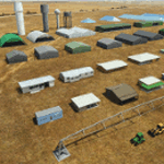
Object libraries for scenery developers (version 10 - improvements on curved surfaces + 10 lights(improved) + 3 windsocks + 3 animals + 5 animated people + 10 fuel_area +stable +fire_tower + 28 new fences + church + sheds). All objects in these libraries will be used in my own sceneries and the result of 100s hrs of effort. All objects from the real world. All objects use LOD (Level Of Detail) to keep frame rates high. Final long distance models have a large triangle added below ground to stop them disappearing in the distance. PBR materials used extensively. Included are 2 PDF files with photos of every object to make selection easy. Republish these files in any freeware scenery if required. READ "read me library instructions" before using.
---------------library1v10-cbj
Cones x4 Gables x3
Church x1
Fences (10 types farm chainlink x4 mesh x2 horse hand-rail paling cattle_grid) x94
Flag pole x1
Fuel_Signs_ x6
Fuel_area_pipes x2
Gas (petrol) station x3
Gliders x4
Glider trailers x4
Grain storage hoppers silos x 4
Power poles x2
Rail platforms station x5
Rail locomotive passenger_carriage grain_hoppers x5
Tower_forest_observation
Towers_radio x6
Weather station small x4
Windsock x3 Windsock-light x1
-------------library2v10-cbj
Animals - Cows x2 Sheep
Grain bunkers - large piles of grain covered with canvas x5
Hangars small airfield x15
Medical transfer station (building) x2
Obstacle-light x10
People x5 Men Women
Pivot irrigator x3
Sheds x10
Shelters x2
Terminals - small airfield x12
Water tanks x3
Towers water x4
Tractors farm x3
Water tanks x3
| Filename: | MSFS_2020_object_library_with_200_models_ranging_f.zip |
| License: | Freeware |
| Added: | 6th March 2022, 19:34:52 |
| Downloads: | 391 |
| Author: | COLIN JEFFERY |
| Size: | 198.25 MB |
| Category: Prepar3D V1-4 - Miscellaneous Files | |
| RNP Approach Procedures for Southeast Alaska, for use with the PMDG 737 NGX |
|
File Description:
These are updated RNP procedures used in Southeast Alaska in conjunction with the PMDG 737.
While similar procedures exist else ware, the goal of these was not to code the exact procedure that is used in real world ops. The reason is because the PMDG 737 isn't capable of flying radius fix legs, which are used extensively in RNP procedures. If the approach and departures are coded as they are in the real aircraft, the flight path is not accurate. All other procedures I have located out there exhibit this limitation, which leads to unstabilized approaches.
The goal with these procedures is to have the PMDG 737 fly the same flight path as the real world procedures. Many of the fixes loaded into the FMS are sudo waypoints but as many of the true fixes are utilized to the extent possible. This means, when you arrive at minimums for the RNP 05 at Petersburg or the RNP 29 at Sitka, very little maneuvering will be required. Installation is a little tedious but will be well worth is.
Included airports and procedures:
Juneau - PAJN
CHLKT1
GLAZZ1
RODMN1
RNAV (RNP) M 08
RNAV (RNP) M 26
Ketchikan - PAKT
ANN3
DOOZI2
UDENE3
RNAV (RNP) M 11
RNAV (RNP) M 29
Petersburg - PAPG
GORBY4
HURAS2
RNAV (RNP) M 05
RNAV (RNP) M 23
Sitka - PASI
RNAV (RNP) M 11
RNAV (RNP) M 29
Wrangle - PAWG
KAJBU5
RNAV (RNP) M 10
RNAV (RNP) M 28
| Filename: | RNP_Approach_Procedures_for_Southeast_Alaska_for_u.zip |
| License: | Freeware |
| Added: | 31st March 2018, 03:31:12 |
| Downloads: | 838 |
| Author: | Trevor Lahey |
| Size: | 10.78 KB |
| Category: Flight Simulator 2004 - Scenery | |
| Maurice Bishop TGPY on Grenada in the Caribbean |
|
Images related to this file:
File Description:
Grenada island is 17 miles south of the southernmost island of the Grenadines, Carriacou; there are some smaller islands between the two. Grenada is 18 miles long and around 8 miles wide, has an estimated population of 110,000, and produces a very large part of the world's annual nutmeg harvest. The capital, St Georges, is by far the largest town and is at the southern end of the island, with the airport close by.
The airport is now called Maurice Bishop, but for some years was called Point Salines. The runway is just over 9,000 feet long and oriented 10/28. Point Salines replaced Pearl Airport, which is on the east coast 12 miles northeast of St Georges and was difficult to expand as the runway had mountains at one end and the sea at the other. Pearl is now closed; it is included here but only as a visual landmark with "closed" markings. There are regular international flights from North America and Europe, some of which are seasonal only (Air Canada for instance) and local connecting flights by LIAT and SVG. I retained the default control tower as it is some distance away. In real life it is also some distance away and on a hill northwest of the terminal. Which is why I did not take photos from which I would have made the real one. The hill does not feature in FS9.
| Filename: | Maurice_Bishop_TGPY_on_Grenada_in_the_Caribbean.zip |
| License: | Freeware, limited distribution |
| Added: | 11th June 2013, 23:28:17 |
| Downloads: | 825 |
| Author: | Roger Wensley |
| Size: | 7.38 MB |
© 2001-2026 AVSIM Online
All Rights Reserved
Privacy Policy |