
Where Flight Simulation Enthusiasts Gather from Around the World!
AVSIM Library - Search Results

| Category: Flight Simulator 2004 - Panels | |
| Wingview for the POSKY Boeing 747-400 |

|
File Description:
Here is my wingview for the Project Open Sky 747-400. It can also be used with the 747-200. Enjoy.
| Filename: | Wingview_for_the_POSKY_Boeing_747400.zip |
| License: | Freeware |
| Added: | 6th February 2005, 04:23:21 |
| Downloads: | 2,234 |
| Author: | Dennis Vormberge |
| Size: | 740 B |
| Category: Flight Simulator X - Aircraft Repaints, Textures and Modifications | |
| Winair - July 2023 - Flightplans for AI Traffic |
|
Images related to this file:
File Description:

Winair Flight Plans July 2023 with new ATR42-500 on fleet. By Alexandre Alves
| Filename: | Winair__July_2023__Flightplans_for_AI_Traffic.zip |
| License: | Freeware |
| Added: | 24th July 2023, 19:59:50 |
| Downloads: | 164 |
| Author: | Alexandre Alves |
| Size: | 4.04 KB |
| Category: Flight Simulator 2004 - Aircraft Repaints, Textures and Modifications | |
| San Juan Aviation Beech C99 for AI |
|
File Description:
Repaint of Henry Tomkiewicz Beech C99 for AI in San Juan Aviation colours.
| Filename: | San_Juan_Aviation_Beech_C99_for_AI.zip |
| License: | Freeware |
| Added: | 27th November 2004, 17:19:23 |
| Downloads: | 746 |
| Author: | Henry Tomkiewicz, Chris Peschke |
| Size: | 130.95 KB |
| Category: Flight Simulator 2004 - Scenery | |
| Scenery Enhancements for the Innsbruck (LOWI), Austria |
|
File Description:
New roads, railroads, streams, river, landclass, and waterclass for the Innsbruck area, Austrian Alps. Based on 30-m and 10-m satellite imagery. Not a finished product but rather a "Sunday afternoon" project :-) to illustrate the visual improvements that can be achieved with a few hours of time commitment and the help of the wonderful Ground2K4 by Christian Fumey. The scenery looks best with one of the SRTM-based add-on meshes. I have included my Ground2K4 source code so that interested users can improve on and expand the project area (requires a separate download of my pre-processed satellite imagery).
| Filename: | Scenery_Enhancements_for_the_Innsbruck_LOWI_Austri.zip |
| License: | Freeware, limited distribution |
| Added: | 1st March 2004, 14:17:27 |
| Downloads: | 21,782 |
| Author: | Holger Sandmann |
| Size: | 1.3 MB |
| Category: Navigation and ATC - Navigation | |
| Caribbean World Aeronautical Chart Chunks for FSMap |
|
File Description:
Sectional chart chunks made from the August 2009 Sectional charts at the original scale, formatted in the WGS84 lat/long geographic coordinate system for the FSMap, moving map application for flight simulation use.
Coverage is the Bahamas, Cuba, Jamaica, Haiti, the Dominican and the Guadeloupe island areas.
The chart chunks are baseline 8bit tiffs with packbit compression applied that are 2750x2480 pixels at about 6.5mb each. Also, included is the FSMap fsm Calibration file for importing. The Caribbean jpegs that were previously uploaded, I lowered the gamma quite a bit due to WAC being too harsh to view on the display. With these tiffs I left them as is, because of the dimming feature in the FSMap gauge, one of the many great features the FSMap package has to offer.
| Filename: | Caribbean_World_Aeronautical_Chart_Chunks_for_FSMa.zip |
| License: | Freeware |
| Added: | 19th March 2010, 01:16:53 |
| Downloads: | 781 |
| Author: | David Myers |
| Size: | 84.36 MB |
| Category: Flight Simulator X - AI Aircraft | |
| Bahamasair Boeing 737-200 fleet for fsx |
|
Images related to this file:
File Description:

Bahamasair fleet of 2 Boeing 737-200s. To be used with the brand new FAIB Boeing 737-200 (logolight model) base package available separately.(Visit fsxaibureau.com for more details). The enclosed textures are native fsx HD textures, that will ONLY show in fsx. If you are using fs9, please use instead the file faib_732_bhs_fs9.zip. Repaint by Philippe Tabatchnik. Visit my website at www.flyingcarpet75.com for more ai repaints
| Filename: | Bahamasair_Boeing_737200_fleet_for_fsx.zip |
| License: | Freeware, limited distribution |
| Added: | 3rd April 2012, 23:36:14 |
| Downloads: | 985 |
| Author: | Philippe Tabatchnik |
| Size: | 1.49 MB |
| Category: Flight Simulator X - Gauges | |
| V-One Callout for Boeing 757/767 |
|
Images related to this file:
File Description:
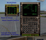
This is a First Officer (F/O) call-out XML gauge specifically for the CS (Captain Sim) 757 and 767. This gauge is not a substitute for correctly programming the CDU/FMS.
V-One Call-Out Sounds and Features-
[Take-Off:] V1, Rotate, Positive Rate, Gear-Up, Flaps-Up, Slats Retract
[Approach:] Slats Extended, Gear Down, Flaps 20, Flaps 25, Flaps 30
[Landing:] Spoilers Deployed*, Auto Thrust Available, 80 knots, 60 knots
[Always Available:] Auto Pilot Engage, Spoilers Deployed**, Altitude Alert
[* Auto spoilers must be armed]
[** Call-Out occurs when spoilers set to full (100%)]
Fuel used is displayed in either LB or KG based on FSX unit settings.
Current aircraft Center of Gravity (CG) is displayed.
Current Trim Units are displayed.
| Filename: | VOne_Callout_for_Boeing_757767.zip |
| License: | Freeware, limited distribution |
| Added: | 8th September 2012, 17:53:07 |
| Downloads: | 3,706 |
| Author: | Paul Tally |
| Size: | 2.46 MB |
| Category: Flight Simulator 2004 - Scenery | |
| Modified SRTM relief 76 m for Slovakia |
|
File Description:
This Slovak terrain mesh 76 m (LOD9) is made from the 3arc-sec SRTM. The voids in the source data were filled by the interpolation. Both the primary processing of the 3arc-sec data and the rendering of the terrain in the FS cause flattening and simplifying of the real shape of the terrain. This phenomenon was partially compensated by the sharpening of the source data.
Made by the programs Surfer (Golden Software) and MS Terrain SDK 2000 and 2002. The relief covers the area N49.9219 E016.1719 to N47.4609 E022.9687 in the boundaries of the LOD9 quadrants. This scenery contains only the elevation data. The other elements of the basic terrain as the landclass, locally used airborne photos, vector roads, rivers and lakes are available in different sceneries by other authors and they are continuously developed.
| Filename: | Modified_SRTM_relief_76_m_for_Slovakia.zip |
| License: | Freeware, limited distribution |
| Added: | 28th May 2010, 19:40:13 |
| Downloads: | 4,615 |
| Author: | Vladimir Stoje |
| Size: | 19.36 MB |
| Category: Flight Simulator 2004 - AI Aircraft | |
| Paintkit for GA Piper PA46 Malibu Mirage |
|
Images related to this file:
File Description:

Re-upload following Avsim hack. Layered paintkit for my 4_GA_Piper_PA46_Malibu_Mirage.zip file here at Avsim. It will only be of use to you if you know how to handle layers. There is a kit in XCF format for The Gimp users, and PSD format for Photoshop and PaintShopPro users. Please refer to the included Readme text.
| Filename: | Paintkit_for_GA_Piper_PA46_Malibu_Mirage.zip |
| License: | Freeware, limited distribution |
| Added: | 31st August 2010, 23:54:58 |
| Downloads: | 751 |
| Author: | Mike Cronin |
| Size: | 575.44 KB |
| Category: Flight Simulator X - Utilities | |
| FsGeoNavi (Geography Navigation for FS2004/FSX) V1.0 |
|
Images related to this file:
File Description:

Don't you get bored when in cruise flight you have nothing to do and don't know where you are?
Then study world geography with FsGeoNavi program!
It provides POI(Point of Interest) information text display in FS screen. POI includes countries, cities, mountains around your aircraft.
Display example : "Largest City : [2 o'clock, 75 NM] Seoul (Korea) - 10349312 people", "Nearest Mountain : [9 o'clock, 50NM] Mount RAINIER (Washington (USA)) - 4393m".
Works with both FS2004 and FSX.
| Filename: | FsGeoNavi_Geography_Navigation_for_FS2004FSX_V10.zip |
| License: | Freeware |
| Added: | 3rd March 2012, 19:11:20 |
| Downloads: | 2,529 |
| Author: | Dongjin Shin |
| Size: | 2.09 MB |


© 2001-2026 AVSIM Online
All Rights Reserved
Privacy Policy |