
Where Flight Simulation Enthusiasts Gather from Around the World!
AVSIM Library - Search Results

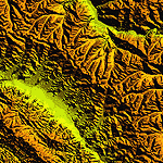
| Category: Flight Simulator 2004 - Scenery | |
| "Himalayan Peaks" LOD10 Mesh, Volume 7 - K2 and Karakoram |

|
Images related to this file:
File Description:

Highly detailed terrain mesh of the Karakoram area, N35-37 E73-77. The files in this package are based on Shuttle Radar (SRTM) Version 2 data but with many of the void areas, especially the most significant sections, filled with elevation data generated from topographic maps by Jonathan de Ferranti. While Jonathan's work is unrelated to flight simulation he kindly gave me permission to compile his data for use in FS. The result is a wonderful improvement in detail and accuracy over any existing mesh file, freeware or commercial, based on SRTM or DTED data alone.
Due to the large area of the Himalayas I've compiled the source data as two separate series: the "Himalayan Peaks" series covers prominent mountains and ranges in higher detail and locally overrides any existing LOD9 terrain mesh. In addition, a LOD9 "base mesh" series covering the entire Himalayas will be available for those who do not yet have an add-on terrain mesh of these beautiful mountains.
| Filename: | Himalayan_Peaks_LOD10_Mesh_Volume_7__K2_and_Karako.zip |
| License: | Freeware, limited distribution |
| Added: | 30th May 2010, 09:56:27 |
| Downloads: | 9,473 |
| Author: | Holger Sandmann, Jonathan de Ferranti |
| Size: | 38.58 MB |
| Category: Flight Simulator 2004 - Scenery | |
| "Himalayan Peaks" LOD10 Mesh, Volume 6 - Jammu and Kashmir |
|
Images related to this file:
File Description:
Highly detailed terrain mesh of the Jammu and Kashmir areas, N31-36 E76-78. The files in this package are based on Shuttle Radar (SRTM) Version 2 data but with many of the void areas, especially the most significant sections, filled with elevation data generated from topographic maps by Jonathan de Ferranti. While Jonathan's work is unrelated to flight simulation he kindly gave me permission to compile his data for use in FS. The result is a wonderful improvement in detail and accuracy over any existing mesh file, freeware or commercial, based on SRTM or DTED data alone.
Due to the large area of the Himalayas I've compiled the source data as two separate series: the "Himalayan Peaks" series covers prominent mountains and ranges in higher detail and locally overrides any existing LOD9 terrain mesh. In addition, a LOD9 "base mesh" series covering the entire Himalayas will be available for those who do not yet have an add-on terrain mesh of these beautiful mountains.
| Filename: | Himalayan_Peaks_LOD10_Mesh_Volume_6__Jammu_and_Kas.zip |
| License: | Freeware, limited distribution |
| Added: | 29th May 2010, 08:55:43 |
| Downloads: | 9,661 |
| Author: | Holger Sandmann, Jonathan de Ferranti |
| Size: | 52.19 MB |
| Category: Flight Simulator 2004 - Scenery | |
| "Himalayan Peaks" LOD10 Mesh, Volume 3 - Namcha Barwa |
|
File Description:
Highly detailed terrain mesh of the Namcha Barwa area, N29°-31° E94°-96°. The files in this package are based on Shuttle Radar (SRTM) Version 2 data but with many of the void areas, especially the most significant sections, filled with elevation data generated from topographic maps by Jonathan de Ferranti. While Jonathan's work is unrelated to flight simulation he kindly gave me permission to compile his data for use in FS. The result is a wonderful improvement in detail and accuracy over any existing mesh file, freeware or commercial, based on SRTM or DTED data alone. Due to the large area of the Himalayas I've compiled the source data as two separate series: the "Himalayan Peaks" series covers prominent mountains and ranges in higher detail and locally overrides any existing LOD9 terrain mesh. In addition, a LOD9 "base mesh" series covering the entire Himalayas will be available for those who do not yet have an add-on terrain mesh of these beautiful mountains.
| Filename: | Himalayan_Peaks_LOD10_Mesh_Volume_3__Namcha_Barwa.zip |
| License: | Freeware, limited distribution |
| Added: | 18th February 2006, 23:15:17 |
| Downloads: | 12,184 |
| Author: | Holger Sandmann and Jonathan de Ferranti |
| Size: | 15.09 MB |
| Category: Flight Simulator 2004 - Scenery | |
| Himalayan Peaks LOD10 Mesh, Volume 1 - Mt. Everest and Kula Kangri |
|
File Description:
Highly detailed terrain mesh of the Mt. Everest and Kula Kangri areas, N26°-29° E85°-92°. The files in this package are based on Shuttle Radar (SRTM) Version 2 data but with many of the void areas, especially the most significant sections, filled with elevation data generated from topographic maps by Jonathan de Ferranti. While Jonathan's work is unrelated to flight simulation he kindly gave me permission to compile his data for use in FS. The result is a wonderful improvement in detail and accuracy over any existing mesh file, freeware or commercial, based on SRTM or DTED data alone. Due to the large area of the Himalayas I've compiled the source data as two separate series: the "Himalayan Peaks" series covers prominent mountains and ranges in higher detail and locally overrides any existing LOD9 terrain mesh. In addition, a LOD9 "base mesh" series covering the entire Himalayas will be available for those who do not yet have an add-on terrain mesh of these beautiful mountains.
| Filename: | Himalayan_Peaks_LOD10_Mesh_Volume_1__Mt_Everest_an.zip |
| License: | Freeware, limited distribution |
| Added: | 9th February 2006, 22:13:00 |
| Downloads: | 37,041 |
| Author: | Holger Sandmann and Jonathan de Ferranti |
| Size: | 52.01 MB |
| Category: Flight Simulator 2004 - Utilities | |
| Measuring Stick |
|
File Description:
An aircraft from AI Aardvark that happens to
look like a 100 meter measuring stick.
Features 2 moving sliders that move in .5m
increments.
If you have a plane that you suspect is out
of scale, now you can find out. Not to be used
to torment modelers, if you find a scale
problem with a model, be nice about it, ok?
Probably works in FS2002, but not tested.
| Filename: | Measuring_Stick.zip |
| License: | Freeware, limited distribution |
| Added: | 10th December 2004, 14:08:05 |
| Downloads: | 982 |
| Author: | David Rawlins |
| Size: | 349.48 KB |
| Category: Flight Simulator 2004 - Panels | |
| Boeing 737 v1.4 2d |
|
File Description:
This 1.4 version has new updates such as GPS and digital fuel meter in the 3d Virtual cockpit! Also fixed the missing NAV2 radio. This is a fully functional panel for your favorite Boeing Airliner that has built in GPS, Radio and Throttle into the 2d panel too. Very easy to install. NOTES: V1.4 has everything V1.0, 1.1, 1.2 and 1.3 have, but added the above mentioned updates. I have had lots of great feedback and welcome ideas/suggested mods. Credit also goes to Alex Stankevitch for his 1.3 update/mods. Feel free to email a suggestion/idea if you want. Please read the readme and most all....Happy flying!
| Filename: | Boeing_737_v14_2d.zip |
| License: | Freeware |
| Added: | 13th October 2004, 04:27:28 |
| Downloads: | 5,758 |
| Author: | Randy Oldfield |
| Size: | 4.44 MB |
| Category: Flight Simulator 2002 - Scenery | |
| Pamalican Island Resort Scenery, Pamalican Island, Philippines |
|
File Description:
PAMALICAN ISLAND RESORT SCENERY, PAMALICAN ISLAND, PHILIPPINES
Version 1.0
July 19,2003
Pamalican Island Resort Scenery is located at Pamalican Island,in the group of Quiniluban Islands,Philippines.It is situated north northwest of Cuyo Island, and south southwest of Mindoro Island.The scenery features an 800-meter gravel airstrip with papi lights and ndb shack.It also features floating resort cottages, resort hotels, static vehicles, yachts, animated bancas, cows, horses, local resident's houses and a small terminal at the ramp more or less similar to the Bantayan terminal.This scenery is an ideal CUYO- PAMALICAN- BUSUANGA- EL NIDO- SANDOVAL- PUERTO PRINCESA adventure short hops. Enjoy the new and improving Philippine sceneries!
| Filename: | Pamalican_Island_Resort_Scenery_Pamalican_Island_P.zip |
| License: | Freeware |
| Added: | 19th July 2003, 17:04:09 |
| Downloads: | 709 |
| Author: | Ver Walter L. Gulfan |
| Size: | 2.47 MB |
| Category: Flight Simulator X - Aircraft Repaints, Textures and Modifications | |
| RAAF "75 Squadron" Dassault Mirage 2000 |
|
Images related to this file:
File Description:

Four fictional Australian repaints for the Payware Metal-to-Mesh Mirage 2000 based off RAAF 75sqn Mirage IIIs.
| Filename: | RAAF_75_Squadron_Dassault_Mirage_2000.zip |
| License: | Freeware, limited distribution |
| Added: | 17th May 2015, 08:49:09 |
| Downloads: | 310 |
| Author: | Ben O'Donnell |
| Size: | 56.28 MB |
| Category: Fly! II - Scenery | |
| Loan und Logf mit Oe-ost Mesh |
|
File Description:
Doc File mit Tips für die Verwendung der Airports von Harald Kraft und der Oe-ost Mesh Scenery.
| Filename: | Loan_und_Logf_mit_Oeost_Mesh.zip |
| License: | Freeware |
| Added: | 30th July 2002, 21:51:53 |
| Downloads: | 151 |
| Author: | Helmut Mayer |
| Size: | 4.84 KB |
| Category: Flight Simulator 2004 - Scenery | |
| Mallorca, Ibiza, Menorca & Formentera Mesh |
|
File Description:
Containes the mesh for the 4 islands - processed by the SRTM global processor and sampled at 3 arcseconds.
| Filename: | Mallorca_Ibiza_Menorca__Formentera_Mesh.zip |
| License: | Freeware |
| Added: | 12th November 2003, 20:26:26 |
| Downloads: | 11,723 |
| Author: | Stefan Braunewell |
| Size: | 5.04 MB |
© 2001-2026 AVSIM Online
All Rights Reserved
Privacy Policy |