
Where Flight Simulation Enthusiasts Gather from Around the World!
AVSIM Library - Search Results

| Category: Flight Simulator 2004 - Scenery | |
| Buffalo Narrows CYVT in Saskatchewan, Canada |

|
Images related to this file:
File Description:
Buffalo Narrows is a small town (around 1,400 folks) 130 miles west and a bit north of La Ronge in Saskatchewan, and I discovered that the Buffalo Narrows airfield, wrongly positioned in FS9, had been flooded out by Ultimate Terrain's lake; this is the rescue package. Actually that would be several lakes as the place is surrounded by water including Churchill Lake, Little Peter Pond Lake, and of course Big Peter Pond Lake.
There are two runways, the longest being 5,006' of 100' wide asphalt aligned 11/29, and the other 2,297 and 75' wide, also asphalt. Both runways are lit, and there is JetA and 100LL fuel available. I have placed taxiway lights, but I haven't made proper signage or placed runway lights, or a ton of other things, but it is now landable and with the buildings and fire chemical retarder tanks etc, and there is AI that includes a CL-415. The roads have also been modified to fit.
| Filename: | Buffalo_Narrows_CYVT_in_Saskatchewan_Canada.zip |
| License: | Freeware, limited distribution |
| Added: | 15th July 2012, 19:31:20 |
| Downloads: | 499 |
| Author: | Roger Wensley |
| Size: | 1.8 MB |
| Category: Flight Simulator X - Scenery | |
| YCRW Crawley Bay, Western Australia, US Catalina Base - QANTAS base (Historic 1942) |
|
File Description:
YCRW Crawley Bay USAF Catalina Base - QANTAS base (Historic 1942). This location was where the famous double sunrise flights left for Lake Koggala in Sri Lanka (Ceylon) between 1943 and 1946. Suited to Rick Stone's PBY5A Catalina. The USAF used the north side of the point and QANTAS used what is now the boat ramp at Nedlands. Remember, Perth was only about two or three stories high in those days so for a realistic enactment, totally overload the aircraft (towards the front) and just point between the buildings until you gain some height. To cover the distance, cruise at about 110kts and 500 feet. Don't forget the passengers stand at the front on takeoff and can be seated after you are in the air. (move the weights backwards after taking off) REQUIRES Blencowe_LibraryKit.zip
REQUIRES blencowe_librarykit_309494.zip (Available HERE)
| Filename: | YCRW_Crawley_Bay_Western_Australia__US_Catalina_Ba.zip |
| License: | Freeware |
| Added: | 25th February 2013, 09:02:15 |
| Downloads: | 301 |
| Author: | Alan Blencowe |
| Size: | 865.95 KB |
| Category: Flight Simulator X - Scenery | |
| YKAE Kalannie, Western Australia |
|
File Description:
YKAE Kalannie, about 300km north-east of Perth, lies in some of the best wildflower country in Australia and at the heart of WA���¢������s largest wheat producing area. The district also claims more species of wattle (acacias) than anywhere else in the world. Kalannie is also situated approximately 30 mins from Dalwallinu in what is called the northern wheatbelt region and is within the Dalwallinu Shire and hence council administration for the area is managed from Dalwallinu. Kalannie has a population of approximately 300 people in the town and immediate region around Kalannie. There is no accommodation at Kalannie except for the Caravan Park. The airstrip is gravel with a windsock and is marked with white plough disks. REQUIRES Blencowe_LibraryKit.zip
REQUIRES blencowe_librarykit_309494.zip (Available HERE)
| Filename: | YKAE_Kalannie_Western_Australia.zip |
| License: | Freeware |
| Added: | 28th February 2013, 13:51:08 |
| Downloads: | 210 |
| Author: | Alan Blencowe |
| Size: | 2.31 MB |
| Category: Flight Simulator 2004 - Scenery | |
| Canouan TVSC in the Grenadines |
|
Images related to this file:
File Description:
Canouan Island is the one of the middle islands in the chain known as St Vincent and the Grenadines, between Mustique and Union Island. Canouan is around 5 miles long and shaped like a hook, with a resident population of 1,200. There has been major touristic development on the island since the early 1990's and the island now has paved roads, electricity, and desalinated water along with a golf course.
The airport is at the southern end of the island and the runway has been extended to 5,875 feet on reclaimed land, making Canouan the jet airport for the Grenadines with flights from North and South America. There are connecting flights to the other islands by SVG and LIAT. The airport apron has been extended to accomodate larger planes and I have shown the airport with this apron work still in progress and during the expansion of the terminal building. The AI has two international flights, on Wednesday and Saturday, and both by American.
| Filename: | Canouan_TVSC_in_the_Grenadines.zip |
| License: | Freeware, limited distribution |
| Added: | 11th June 2013, 22:59:04 |
| Downloads: | 656 |
| Author: | Roger Wensley |
| Size: | 3.6 MB |
| Category: Flight Simulator X - AFCAD Files | |
| FGBT - Bata Airport - Bata, Equatorial Guinea |
|
File Description:
Bata Airport (IATA: BSG, ICAO: FGBT) is the second largest airport in Equatorial Guinea, after Malabo Airport, and is the only other paved runway. The airport is located some way north of Bata and a short way south of Utonde, it has a
2.3 km runway that operates only during the daytime and in good light. The state carrier and four other private companies make up the majority of Bata's industry, transporting passengers from Bioko's international airport or the two
800m strips on Annobon or Mongomo. The airport is large enough to accommodate a Boeing 737. Bata served 15,000 passengers in 2001. In July 2002, all staff at the airport were arrested for allowing the leader of the Popular Union, an o
pposition party, to board a flight to the Gabon. The tower frequency is 118.800 MHz (VHF).
Airport elevation and two runways were corrected also the aprons and buildinds. Airport charts cortesy of vatcaf.flyvatsimafrica.org
This work is dedicated to West Wind Airlines.
| Filename: | FGBT__Bata_Airport__Bata_Equatorial_Guinea.zip |
| License: | Freeware |
| Added: | 19th May 2013, 17:22:05 |
| Downloads: | 765 |
| Author: | Anwar Gonzalez |
| Size: | 677.55 KB |
| Category: Flight Simulator 2004 - Scenery | |
| CYEK - Arviat - Nunavut, Canada v 1.1 |
|
Images related to this file:
File Description:
This version of Arviat corrects the VASI position on the runway, and also updates the taxiway edge lights to a newer and smaller version which is more realistically sized. This is a complete version and does not require you to have installed the old version. You can just replace the existing .bgl's and the existing textures in the scenery and texture folders if you already have this scenery. Arviat is a small town on the west coast of Hudson Bay in Nunavut, around 90 miles south of Whale Cove, 130 miles south of Rankin Inlet, and 160 miles north of Churchill. The airfield is just south of the town, and the 4,000 feet of gravel runway is aligned 149T/329T, as these are true bearings and not magnetic, as Arviat is just inside the Northern Domestic Airspace zone. There is 100LL fuel available in drums, with 2 hours prior notice. The visiting AI airline is Calm Air, plus a cargo delivery by Buffalo Air.
| Filename: | CYEK__Arviat__Nunavut_Canada_v_11.zip |
| License: | Freeware, limited distribution |
| Added: | 23rd August 2014, 11:20:05 |
| Downloads: | 226 |
| Author: | Roger Wensley |
| Size: | 2.33 MB |
| Category: Flight Simulator X - Aircraft Repaints, Textures and Modifications | |
| Qatar Airways Boeing 777-300ER GE (A7-BAW) |
|
Images related to this file:
File Description:

This is a repaint of a Boeing 777-300ER, registration code A7-BAW, operated by Qatar Airways, the flag carrier of Qatar. Headquartered in Doha, Qatar Airways operates services across Africa, Central Asia, Europe, Far East, South Asia, Middle East, North America, South America and Oceania. Qatar Airways uses the Arabian Oryx as its logo and currently operates 25 Boeing 777-300ERs.
This repaint has plenty of clear markings so if you enjoy exterior detail, then you will love this repaint. You can see (and read): Door opening instructions; Static port directions; Air vent warnings; Engine hazard area; No Step warnings; RAT caution; APU intake warning; Stabilizer compartment access; Ground power supply; Forward and aft access door instructions; Pitot, ADA probe, Ice detector and TAT probe markings; Visible rivets; Enhanced window frames; Authentic Qatar logo; Bold, colorful Qatar livery and authentic flags; Lovely Qatar flight attendant; No frame rate hit.
| Filename: | Qatar_Airways_Boeing_777300ER_GE_A7BAW.zip |
| License: | Freeware |
| Added: | 6th April 2014, 22:47:27 |
| Downloads: | 1,434 |
| Author: | Garrett Rowley, Captain Sim |
| Size: | 29.56 MB |
| Category: Flight Simulator X - Scenery | |
| Dieuze - Gueblange V2 |
|
Images related to this file:
File Description:
This scenery depicts Dieuze-Gueblange aerodrome located in the north east of France. It is a very accurate rendition of this aerodrome made with photoreal textures for the ground and the objects. The ground is covered with volumetric grass. I have modelled an animated sock that indicates the wind direction and velocity. To see this windsock, Sode (Sim Objects Display Engine) module must be installed (module availabale here : http://sode.12bpilot.ch/?page_id=9). A user manual (pdf) is included.
The windsock library may be used in your own sceneries. If you share a scenery using this library, you must add the BJP_SOCKS folder without any modification in order to avoid duplicate files. Please include my name in any of your included documents. This new release is now compatible with a landclass environment: snowy ground and trees in the hard winter (from the first day of december to the last day of january). Please read the specific enclosed manual.
| Filename: | Dieuze__Gueblange_V2.zip |
| License: | Freeware, limited distribution |
| Added: | 1st February 2015, 23:14:45 |
| Downloads: | 1,451 |
| Author: | Jacques-Paul Bollard |
| Size: | 21.98 MB |
| Category: Flight Simulator X - Aircraft Repaints, Textures and Modifications | |
| Boeing B-17G (42-102550) |
|
Images related to this file:
File Description:
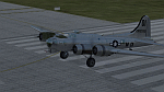
B-17G-55-BO 42-102550 of the 452nd BG. 42-102550 crashed on November 29, 1944, at Charlotte, North Carolina. Icy conditions caused the new B-17 to skid off the end of the runway and come to rest on the Southern Railway tracks as train was approaching. Crew No. 590 of Squadron "S" of the 326th base Unit training pout of MacDill. Irony is they just won "Crew of the Month" so they were allowed to fly anywhere they wanted to, so for their reward, they flew to Charlotte N.C. No injuries, the crew landed long and overran the end of the runway. A great story with a local woman who put a broom in a fire so it could be used to flag down an oncoming train! The plane had to be destroyed to get it off the tracks and the military split up the crew as punishment.
Repaint by Will "dafraz48" Turner, based on the A2A paintkit, March 2015.
| Filename: | Boeing_B17G_42102550.zip |
| License: | Freeware |
| Added: | 11th March 2015, 13:51:53 |
| Downloads: | 93 |
| Author: | Will Turner |
| Size: | 11.67 MB |
| Category: Flight Simulator 2004 - Scenery | |
| Ontario Small Fields in Canada: #04 Stoney Point (Le Cunff) CRML V1 |
|
Images related to this file:
File Description:
This is the fourth in a series of small airfields in southern Ontario, Canada. It is Stoney Point (Le Cunff) CRML, a field near a small town (Stoney Point) close to Lake St Clair. The airfield has a grass runway of 2,250 feet, aligned 18/36; with trees around the house gardens between road and runway the south threshold is displaced by 250 feet. The markers approximately show the touchdown point north of the runway end. Le Cunff is the family name of the owners, included to differentiate between this and another Stoney Point field, CRJ2. I found the default FS9 airfield at the correct elevation of 625 feet, but sitting on a plateau, despite my Genesis Mesh. This looked so unreal that I have revised this to an incorrect lower elevation of 580. So if you find the airfield sitting in a hole in your installation you now know the reason. Let me know, with a screenshot please.
| Filename: | Ontario_Small_Fields_in_Canada_04_Stoney_Point_Le_.zip |
| License: | Freeware, limited distribution |
| Added: | 29th July 2015, 16:08:32 |
| Downloads: | 146 |
| Author: | Roger Wensley |
| Size: | 1.6 MB |


© 2001-2026 AVSIM Online
All Rights Reserved
Privacy Policy |