
Where Flight Simulation Enthusiasts Gather from Around the World!
AVSIM Library - Search Results

| Category: Flight Simulator 2004 - AI Flight Plans | |
| Gladiators Complete AI Package |

|
Images related to this file:
File Description:

The members of Military AI Works are proud to bring you the Gladiators Complete AI Package for FS2004. This package depicts VFA-106 which is the United States Navy and United States Marine Corps east coast Hornet and Superhornet fleet replacement squadron. This squadron is used to train new and transitioning F/A-18 pilots and weapon systems operators. This package depicts VFA-106 operations at NAS Oceana as well as the detachments at NAS Key West. As a bonus, this package also depicts the F-5s of VFC-111 stationed at NAS Key West. Credits: Models by Jake Burrus and Nick Black, Repaints by Graham King, Mark Heimer and Lewis Macgruder, FDE/Effects by Mike MacIntyre, Nick Needham, Steve Holland and Henry Tomkiewicz, AFCADs by John Stinstrom and Desmond Burrell, VCPs by Stewart Pearson and Desmond Burrell, Scenery by Johns Stinstrom and Marcel Ritzema
| Filename: | Gladiators_Complete_AI_Package.zip |
| License: | Freeware, limited distribution |
| Added: | 6th February 2012, 04:02:23 |
| Downloads: | 1,031 |
| Author: | Desmond Burrell, Military AI Works (MAIW) |
| Size: | 30.28 MB |
| Category: X-Plane - Aircraft Repaints, Textures and Modifications | |
| 118527 "Jiminy Cricket" Douglas C-47D |
|
Images related to this file:
File Description:
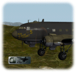
This is a livery-paint for the Leading Edge Simulations Douglas DC3/C47.
Paint made by Leen "Flybike" de Jager
This paint depicts (more or less,within the limitations of the model and its painter) the C47-D ,118527 "Jiminy Cricket "
Historical Note:
"Jiminy Cricket" is depicted as it flew for the Sicily operation in improvised night camouflage.
It was one of the original 52 C-47s that deployed to Egypt with the 316thTCG in December 1942.
"Jiminy Cricket" was one of the first from the 316th Sq.
ATC, to visit Project 19, delivering worn out parts and returning rebuilt
engines to the RAF. It eventually took part in the invasion of Sicily,
where, the pilot, Sgt. George Quisenberry received wounds from German FLAK.
The shell destroyed the nose of the Aircraft, knocking out all instruments
except the stand by compass. Jiminy carried the crew back with nothing but
the moon and the sticking standby compass. Jiminy Cricket was repaired and
served through May 1, 1947, then was "salvaged"
The skin-set includes cockpit- and (freighter-) cabin textures as well.
Passenger-seats, luggage-racks ,airco etc.removed from the plane.( its a freighter now !!)
Livery dedicated panel and cockpit colors
How to install:
Just unzip118527JiminyCricket.zip into a temp. folder , and start reading the readme file.
Have fun and enjoy,
Leen "Flybike" de Jager
http://www.flybike-paints.nl
| Filename: | 118527_Jiminy_Cricket_Douglas_C47D.zip |
| License: | Freeware, limited distribution |
| Added: | 22nd June 2013, 16:59:45 |
| Downloads: | 183 |
| Author: | Leen "Flybike" de Jager |
| Size: | 40.26 MB |
| Category: Flight Simulator X - Missions | |
| Mountain Flying in Switzerland (Part 1 of 3) |
|
Images related to this file:
File Description:
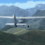
Mountain Flying in Switzerland (Part 1 of 3)
Welcome to beautiful Geneva, Switzerland. Today is a gorgeous day to be taking your first mountain flight in the Swiss Alps. Your round trip will take you over two mountain passes, an airport in the middle of a steep sided canyon and another airport in the heart of the Alps Part 1 of 3: Col de Coux - This first leg takes you from the grass runway in Geneva up and over a mountain pass named Col de Coux and down to an airport in a canyon. Along the way you will be able to enjoy all the beautiful scenery, including incredible views of the snow covered Alps and Lake Geneva, with its world famous jet d'eau. The chief flight instructor from the Aeroclub de Geneve will help you navigate and also handle all the radio communications, but it will be up to you to safely arrive at your destination. You are the Pilot in Command! Includes: - Detailed aeronautical charts of your departure, route, and arrival - FSX Nav Log, Flightplan and GPS with programmed waypoints - Real world voice actors with written text of entire dialog.
| Filename: | Mountain_Flying_in_Switzerland_Part_1_of_3.zip |
| License: | Freeware |
| Added: | 24th June 2010, 01:33:36 |
| Downloads: | 2,698 |
| Author: | Chris Klein |
| Size: | 33.32 MB |
| Category: Prepar3D V1-4 - Aircraft Repaints, Textures and Modifications | |
| Mandarin Airlines 1998 AI Package |
|
File Description:
Mandarin Airlines was a fully-owned affiliate of China Airlines based in RCTP. Today, Mandarin does mostly regional flying, but 1998 represented the final years of widebody operations for the carrier. The 747SPs were retired soon after, and the MD-11s and 747-400 gradually returned to China Airlines. Mandarin operated most of the US, Australian, European, and Middle Eastern flights for China Airlines at the time. Mandarin aircraft frequently swapped back and forth onto China Airlines routes and vice versa. As Mandarin had a small fleet, I elected to have Mandarin planes on Mandarin routes, but my China Airlines plans will also utilize Mandarin colors MD-11s on China Airlines routes, so the repaints in this file are required for China Airlines 1998. Swap out the aircraft as you see fit. Repaints by the talented Ranmori Scythe included for the FAIB 747-400, 747SP, and FSPX MD-11 included with flightplans by the not-so-talented Chasen Richardson. Part of the 1998 Flight Simulator Project. Follow us on Facebook at facebook.com/flightsim98 and on instagram as @bayviationsim. For more Retro AI, check out the forums at: http://retroai.proboards.com/
| Filename: | Mandarin_Airlines_1998_AI_Package.zip |
| License: | Freeware, limited distribution |
| Added: | 21st November 2019, 19:18:20 |
| Downloads: | 249 |
| Author: | Ranmori Scythe, Chasen Richardson/Bayviation |
| Size: | 8.86 MB |
| Category: Flight Simulator X - Scenery | |
| RAF Lasham Airfield |
|
File Description:
RAF Lasham opened in November 1942 as a Forward fighter airfield. It was situated 6 miles south east of Basingstoke in Hampshire. It was initally home to 38 Wing, Army Co-operation Command and was transferred to Fighter Command, in June 1943. The base became home to 175 Sqn flying Hurricanes and Typhoons, 181, 182 and 183 Sqns flying Typhoons, 412 and 602 Sqns with Spitfires. In August 1943 it was transferred to No 2 Group, Tactical AF, becoming home to 320 Sqn flying Mitchells, 107, 613 and 305 Sqns flying Mosquitoes. These squadrons were Heavily involved in Operations Overlord and Market Garden. In November 1944 Lasham was transfered to No 84 Group Support Unit and used for the training replacement aircrews. After the war it became a Group Disbandment Centre. and was fianlly home to 49 MU. and General Aircraft Ltd based servicing RAF Mosquitoes.
| Filename: | RAF_Lasham_Airfield.zip |
| License: | Freeware |
| Added: | 18th March 2009, 13:45:46 |
| Downloads: | 509 |
| Author: | Chris Smith |
| Size: | 1.04 MB |
| Category: Flight Simulator 2004 - Scenery | |
| Kangiqsujuaq CYKF in northern Quebec, Canada |
|
Images related to this file:
File Description:
Kangiqsujuaq is on the north coast of Quebec, 85 miles west of Quaqtaq and 125 miles east of Salluit, while across the Hudson Strait and 100 miles away on Baffin Island is Kimmirut. The town grew around two trading posts, the first opened by Revillon Freres in 1910, and the second by the Hudson Bay Company in 1914. A school was opened in 1960, and a clinic in 1961. The town was known as Wakeham Bay until 1961, and now has a population of around 700. The airport is to the south of the town and up on the hill at 511 feet ASL (this has been remeasured since 2004 and is now known to be 501). The gravel runway is just over 3,500 feet long and aligned 15/33; there is no PAPI, but there is fuel available, both 100LL and JetA. There are flights by Air Inuit.
| Filename: | Kangiqsujuaq_CYKF_in_northern_Quebec_Canada.zip |
| License: | Freeware, limited distribution |
| Added: | 27th January 2013, 00:55:00 |
| Downloads: | 234 |
| Author: | Roger Wensley |
| Size: | 2.31 MB |
| Category: Flight Simulator 2004 - AFCAD Files | |
| ZYCC - Changchun Longjia |
|
Images related to this file:
File Description:
Changchun Longjia airport (ZYCC) opened in august 2005 replacing the old Dafangchen airport. This improved ADE/AFCAD file will update Dafangchen ICAO (to ZY15) and add Longjia airport, which is absent from FS9 stock scenery, using its current ZYCC designator. Features: terrain rework around Longjia, airport layout made upon satellite imagery with pinpoint accuracy (runway, aprons, taxiways, airport roads, objects placement), Navaids, ATC frequencies, taxiways (with taxisigns) & parking stands according to AIP, approach code (ILS & NDB procedures for rwys 06 & 24) with transitions for UI aircraft, basic terminal & buildings with jetways & night lightning, parking stands coded & sized according to AIG standards, and an EVP mod for 'Longjia' agent name. Airport fully working for AI traffic: all your traffic set to/from ZYCC will now use Longjia. Read carefully readme for details & installation instructions.
| Filename: | ZYCC__Changchun_Longjia.zip |
| License: | Freeware, limited distribution |
| Added: | 11th October 2010, 23:10:13 |
| Downloads: | 499 |
| Author: | Yohann Baptiste |
| Size: | 30.89 KB |
| Category: Flight Simulator 2004 - Scenery | |
| FoxPine AirPark, New Zealand. NZFP. |
|
File Description:
Welcome to FoxPine Airpark ,NZFP.
FoxPine AirPark is situated by the small provincial town of Foxton on the South West coast of New Zealand’s North Island.
This Private Airfield set in park-like grounds is sited on a broad coastal plain of mixed farming and forestry bounded by sweeping beaches,
a meandering river, and off to the East, rugged bush-clad ranges, all great places to fly.
FoxPine is also where the "Jabiru" light aircraft is assembled, sold and serviced.
This scenery contains a bonus custom AI package, comprising of seven Jabiru-2's, a Cessna 172, and a Maule M6, and a traffic file for the aircraft. (AI Aircraft are complete with all files).
The AI aircraft, and the traffic file are fully compatible with GNZLAP traffic. Scenery requires some EZ Scenery Object Sets (see INSTALL instructions for details).
| Filename: | FoxPine_AirPark_New_Zealand__NZFP.zip |
| License: | Freeware, limited distribution |
| Added: | 14th August 2008, 21:27:16 |
| Downloads: | 930 |
| Author: | Lawrie Roache |
| Size: | 5.98 MB |
| Category: Flight Simulator 2004 - Scenery | |
| Alaska North Slope 3: Atqasuk (PATQ) |
|
Images related to this file:
File Description:
The town of Barrow is in the far north of Alaska, and these are coastal villages or radar installations to the west and south of Barrow. There will be further additions. Atqasuk PATQ is 55 miles south of Barrow and is unusual in that it is one of the few settlements of the North Slope that is not on the coast. It is, however, on a narrow winding river that reaches the sea to the east of Barrow and seemingly provides fish in abundance. There could well be other good reasons for the village to be where it is, but they are unknown to me. The population is around 250. The airfield is to the south of the village and the runway is 4,900 feet of gravel aligned 06-24, lit, and with PAPI at each end.
| Filename: | Alaska_North_Slope_3_Atqasuk_PATQ.zip |
| License: | Freeware, limited distribution |
| Added: | 17th June 2016, 08:54:55 |
| Downloads: | 235 |
| Author: | Roger Wensley |
| Size: | 2.35 MB |
| Category: Flight Simulator X - Aircraft Repaints, Textures and Modifications | |
| Alpha Air "TWA Express 1995" Beechcraft 1900C |
|
File Description:
Alpha Air was an independent LAX based commuter airline who began operating as a Trans World Express(TWE) carrier in the mid 90s. With a fleet of 3 B1900Cs, in a mix of TWE and Alpha Air liveries, the B1900s did a combination of flying to resort cities like Mammoth Lakes, South Lake Tahoe, and the Grand Canyon and commuter flying between SoCal airports like BUR, SNA, and PSP with the route network stretching as far East as Phoenix. Between 1994 and 1995, most of the commuter routes(all except LAX-PSP-PHX) were dropped in favor of adding flights between TVL and SFO several times daily, GCN was also dropped around this time. These plans combine 94/95 to represent all routes flown in the mid-90s. Also included are textures for the full fleet with 3 variations of the HTAI B1900C.
| Filename: | Alpha_Air_TWA_Express_1995_Beechcraft_1900C.zip |
| License: | Freeware |
| Added: | 25th January 2017, 00:32:25 |
| Downloads: | 176 |
| Author: | Chasen Richardson |
| Size: | 1.86 MB |


© 2001-2026 AVSIM Online
All Rights Reserved
Privacy Policy |