
Where Flight Simulation Enthusiasts Gather from Around the World!
AVSIM Library - Search Results

| Category: Prepar3D V1-4 - Scenery | |
| LOAG-Airport |

|
Images related to this file:
File Description:
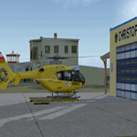
The Civil Aerodrome LOAG is located north of Gneixendorf, about 10 kilometers
east of Krems. Since 2014, there is also a heliport located on the site of the airport (ICAO code:LOBK). It is base to the crew of the Christophorus 2 rescue helicopter which is now fully functional.
This airfield is transfered, with kind permission from Mr. Gerhard Scholz, from his x-plane Version with ADE.
have a look on his homepage http://www.x-plane.at.
This scenery is compatible with "Austria Professional HD"
| Filename: | LOAGAirport.zip |
| License: | Freeware |
| Added: | 5th December 2017, 16:40:56 |
| Downloads: | 685 |
| Author: | Karl Malle |
| Size: | 9.44 MB |
| Category: Flight Simulator 2004 - Aircraft Repaints, Textures and Modifications | |
| MATVA SEA B747-400ER |
|
File Description:
Established Scottish VA The MATVA Group is pleased to present the aircraft of their newest acquisition South East Asia Airways or S.E.A as it will be known. First up is Posky's excellent B747-400ER GE. Many thanks to them for yet another fine model. I know a lot of you collect our stuff so feel free to visit our web-site, you may even be tempted to join us. You are allowed to give in to this temptation :O) www.matvagroup.co.uk
| Filename: | MATVA_SEA_B747400ER.zip |
| License: | Freeware |
| Added: | 22nd November 2005, 12:39:23 |
| Downloads: | 165 |
| Author: | POSKY, Louie Maclennan MATVA |
| Size: | 1.74 MB |
| Category: Flight Simulator X - AFCAD Files | |
| Essex County Airport (KCDW), NJ |
|
File Description:
Located 02 miles N of Caldwell, New Jersey on 275 acres of land, Essex County Airport is a public airport with two asphalt runways, the longest of which is 4552'. Major changes include Runway 9/27 updated to the current 10/28; Runway 4/22 markings are custom made to match the real world, with threshold stripes on Runway 22 only; the beacon has been relocated to its real world location atop the control tower. Additionally, 221 parking locations have been accurately placed around the airport, broken up into 6 sections. See the included airport diagram that labels the various parking areas. 89 of these parking spaces are labeled RAMP_GA and these spaces are occupied by static aircraft. Collision with all static aircraft is disabled but still, if you do not want to start occupying the same space as another airplane, do not choose parking spots labeled RAMP_GA. Instead, all user aircraft should choose either RAMP_GA_SMALL (for wingspans up to 40') or RAMP_GA_MEDIUM (for wingspans up to 60' and only available in East Parking). Also, only 86 of these parking spaces are available for AI aircraft to spawn in. There are hangars available to transient aircraft: the two in South and Southeast parking are able to accommodate small craft with wingspans up to 40'; the one in Northeast parking is able to accommodate larger aircraft with wingspans up to 54'. Helicopters can start either on Taxiway P (South helipad), Taxiway N (North helipad) or in front of the main terminal (East helipad). Fuel is available in both the East and South parking areas by stopping anywhere on the concrete next to the fuel tank/pump. Take note that the runway patterns are both Left and Right and the pattern altitude varies for aircraft type. There are known issues with the AI for this airport, see the ReadMe for more details.
Scenery constructed with use of satellite images/streetview/aerial photos - the author has not been there in person.
This scenery is meant to be used in conjunction with MegaScenery Earth New York 005. It is not required, but apron use is minimized to allow satellite scenery to show through as much as possible, and objects are placed based on the MSE textures - lack of it may make scenery look out of place.
| Filename: | Essex_County_Airport_KCDW_NJ.zip |
| License: | Freeware |
| Added: | 14th April 2011, 01:50:13 |
| Downloads: | 416 |
| Author: | Drew Sikora |
| Size: | 2.4 MB |
| Category: Flight Simulator X - AFCAD Files | |
| EGUW Wattisham Army Air Base, Suffolk, England |
|
Images related to this file:
File Description:
Wattisham is a large Army Air Corps base in Suffolk, England. The stock airport on my version of FSX showed only a runway with a control tower in the middle of it, not good for fixed wing aircraft.
I have used Airport Design Editor (ADE) and Google Earth to rework the airfield. The ILS did not work on my version so I have added a new one, I had to "orphan" the stock ILS, so it will look odd on your GPS, but it works well. See the ReadMe file for the other things I have done to make EGUW more realistic and Download Jim Dhaenens great light package for the apron lights.
If you have other *.bgl files for EGUW then remove them before installing this design.
Just copy the two .bgl files into C: ...../Microsoft Games/Microsoft Flight Simulator X/Addon Scenery/scenery
Any problems contact me at [email protected]
| Filename: | EGUW_Wattisham_Army_Air_Base_Suffolk_England.zip |
| License: | Freeware |
| Added: | 17th August 2013, 11:37:52 |
| Downloads: | 297 |
| Author: | Mike Major |
| Size: | 10.87 KB |
| Category: Flight Simulator X - Scenery Design | |
| YWKM - Wyalkatchem, Western Australia |
|
File Description:
YWKM Wyalkatchem is at the centre of Western Australia's wheat belt, about 200 kilometres North-East of Perth. The town is thought to have been named after the Wyalkatchem Tank which was built by sandalwood cutters in 1881. Wyalkatchem is in some of Western Australia's best wildflower country. If you haven't flown over Wyalkatchem recently, you will notice the raw freshly graded surface and new strip,
recently upgraded under Regional Airports Development Scheme. Due to the tight budget of the state funded strip, taxiways, line marking and lighting of the new strip are not completed. Requires Blencowe_LibraryKit.zip.
REQUIRES blencowe_librarykit_309494.zip (Available HERE)
| Filename: | YWKM__Wyalkatchem_Western_Australia.zip |
| License: | Freeware |
| Added: | 28th February 2013, 17:00:06 |
| Downloads: | 219 |
| Author: | Alan Blencowe |
| Size: | 3.52 MB |
| Category: Microsoft Flight Simulator (2020) - Aircraft Repaints, Textures and Modifications | |
| Ryan ST-A RAAF A50-28 |
|
Images related to this file:
File Description:
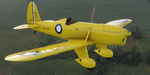
This folder contains a repaint for the Ryan ST-A by A1R Design Bureau. It shows Ryan ST-M A50-28 of the RAAF. This aircraft was built in 1940 for the Dutch East Indies Navy and arrived in Surabaya in November 1940. It was registered S-48 with the Dutch Navy. Together with all other Dutch Ryans, it was shipped to Australia in early 1942, where they were taken on charge by the RAAF, S-48 becoming A50-28. It served with 3 Elementary Flying School at Essendon and later with 2 Air Observer School at Mt Gambier airfield in SA. After the war, it was scrapped.. Repaint by Jan Kees Blom.
| Filename: | Ryan_STA_RAAF_A5028.zip |
| License: | Freeware |
| Added: | 7th June 2021, 17:33:34 |
| Downloads: | 16 |
| Author: | Jan Kees Blom |
| Size: | 47.24 MB |
| Category: Flight Simulator 2004 - Scenery | |
| Nanjing Dajiaochang Z08T - Chinese Airports From Yesteryear No.1 |
|
Images related to this file:
File Description:
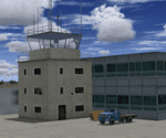
Built with ADE with satellite aligning. Reqiures EZ scenery library: https://www.flightsim.com/files/file/143843-fs2004-ez-scenery-librarys-exe/.
This is the first airport in this series, focusing on old airports in China that now only lives in memory. Nanjing Dajiaochang Airport (NKG/Z08T) was an airport that served Nanjing, the capital of East China's Jiangsu province. It is located 6.2 kilometres (3.9 mi) south of Xinjiekou, the center of Nanjing, and is surrounded on three sides by the Qinhuai River. Opened in 1934, it was an important Chinese airbase during WWII. Civil aviation moved to the new Lukou International Airport in 1997, and then the airforce moved out in 2015 when Dajiaochang finally closed.
| Filename: | Nanjing_Dajiaochang_Z08T__Chinese_Airports_From_Ye.zip |
| License: | Freeware |
| Added: | 23rd July 2024, 00:59:47 |
| Downloads: | 49 |
| Author: | Yue Pan |
| Size: | 101.1 KB |
| Category: Flight Simulator 2004 - Scenery | |
| Cabo Rojo (MDCR), Dominican Republic |
|
File Description:
This file is intended to COMPLETELY replace the older versions of scenery designed for Cabo Rojo (cabo_rojo.zip). This file, written in xml language and compiled using the new FS2004 SDK's should be compatible with all near-future versions of MSFS (or at least thats what they promise - LOL).
Once installed, you will see Cabo Rojo Airport, along with its paved runway and all the airport buildings.
In addition you will find a little "surprise experiment", located to the east of the airport, the Dominican R/C Airfield, a small radio-control aircraft facility. This "airport" will show up on your GPS, but is intended only for the RC AI Traffic files that are included in this download.
| Filename: | Cabo_Rojo_MDCR_Dominican_Republic.zip |
| License: | Freeware, limited distribution |
| Added: | 3rd March 2005, 17:01:33 |
| Downloads: | 2,121 |
| Author: | Todd Lucas |
| Size: | 5.75 MB |
| Category: Flight Simulator 2004 - Scenery | |
| Sturt Point CWSP in Nunavut, Canada |
|
Images related to this file:
File Description:
Sturt Point was a DEW line I Station on the south coast of Victoria Island, 50 miles east of Cambridge Bay. It was closed in 1963 but remains in place, though a 5 man I Station has such a small impact on its surroundings that it is hardly visible. The runway is 3,420 feet of gravel aligned 117T/297T, and there are no lights, signage, or windsock, but there are ruts in the gravel. A North Warning System station was built 15 miles inland and closer to Cambridge Bay, operating from 1991 onwards. This has a short (1,280'?) gravel runway aligned 138T/318T (and named CWSX here). No ruts in the gravel, but also still no lights, signage, or windsock.
| Filename: | Sturt_Point_CWSP_in_Nunavut_Canada.zip |
| License: | Freeware, limited distribution |
| Added: | 11th November 2012, 21:07:18 |
| Downloads: | 209 |
| Author: | Roger Wensley |
| Size: | 1.35 MB |
| Category: Flight Simulator 2004 - Flight Plans | |
| Hopping Round the World Adventure - Pack 19 |
|
File Description:
No better way to pushback from the gate in Raleigh-Durham than with the SGA MD83 using the thrust reverser. Such an authentic feel to it! Also making the rounds is the Piper J-3 Cub for a short stroll. There is no missing the noisy SGA Boeing 737-200 as you experience your first snow shower while heading to Indiana International Airport. Nice job Microsoft on the realistic snow bounderies. Look for em while in flight. Keep on your toes as things could get hairy if you have a lapse in judgement. This was a very fun pack for me and I know you will enjoy it too! Next up is Canada and back to the USA to hop around the East Coast and New England.
| Filename: | Hopping_Round_the_World_Adventure__Pack_19.zip |
| License: | Freeware |
| Added: | 14th December 2003, 04:18:00 |
| Downloads: | 3,174 |
| Author: | David Dossiere |
| Size: | 2.25 MB |


© 2001-2026 AVSIM Online
All Rights Reserved
Privacy Policy |