
Where Flight Simulation Enthusiasts Gather from Around the World!
AVSIM Library - Search Results

| Category: Flight Simulator 2004 - AI Aircraft | |
| AMI 46th Brigata Aerea Complete Package |

|
Images related to this file:
File Description:

This freeware AI package, produced by Military AI Works contains everything needed to activate AMI's 46th Brigata Aerea in FS2004.
The 46th Brigata Aerea 'Silvio Angelucci' is the only squadron committed to air transport within the Italian Air Force, and one of
the most prestigious. the 46th Brigata Aerea is equipped with C-27 Spartans and the most recent versions of the C-130, and hosts a
crew training facility as well as maintenance facilities at Pisa-San Giusto (LIRP). The squadron is divided into three operational
groups. All of these units are included in this package, which contains repaints, AFCADs, flight plans and custom call signs for
each depicted unit. As a bonus, two further C-27s based in Italy are included. Credits: AFCADs: Miljan Korac, Giacomo Gramazio,
Stewart Pearson and Giorgio Perotti, Scenery objects: Mike Guenther and John Stinstrom, Models: Miljan Korac and Henry Tomkiewicz,
FDE and Effects Design: Michael McIntyre, Henry Tomkiewicz and John Stinstrom, Repaints: Michael Pearson and Graham King,
Voicepacks: Stewart Pearson, Flightplans and waypoints: Giacomo Gramazio
| Filename: | AMI_46th_Brigata_Aerea_Complete_Package.zip |
| License: | Freeware |
| Added: | 29th January 2014, 08:33:36 |
| Downloads: | 753 |
| Author: | MAIW - Giacomo Gramazio |
| Size: | 15.55 MB |
| Category: Flight Simulator 2004 - Scenery | |
| Union Island TVSU in the Grenadines |
|
Images related to this file:
File Description:
Union Island is in the southern tail of the chain of islands known as St Vincent and the Grenadines, between Canouan and Carriacou. Union is another small island, 3.5 miles long and at its widest 1.5 miles wide; the resident population is around 3,000, mostly in the two towns Clifton and Ashton.
The airport is at the eastern end of the island, and has been extended into the sea on landfill. The runway is now around 2,480 feet long, aligned 08 (and with the southeast trade winds it is unlikely that you will find yourself using 26) and with a displaced threshold of 530 feet due to the hill to the west. The terminal is adjacent to a rather small apron; there is parking on the grass north of the taxiway. There are connecting flights by SVG to Barbados and the other islands and these are reflected in the AI. The airport has no lighting, and flights are obliged to land and depart in daylight hours only, outside of which the airport is closed.
| Filename: | Union_Island_TVSU_in_the_Grenadines.zip |
| License: | Freeware, limited distribution |
| Added: | 11th June 2013, 23:26:50 |
| Downloads: | 435 |
| Author: | Roger Wensley |
| Size: | 2.02 MB |
| Category: Flight Simulator X - Aircraft Repaints, Textures and Modifications | |
| Airbus A330-300RR V2.1 |
|
File Description:
**** THIS FILE SUPERCEEDS MY ORIGINAL FILE posky_a330_300_v2_fsx.zip **** v2.1 - REPORTED BUGS HAVE BEEN CORRECTED. Introducing the Project Opensky A330-300 for Microsoft Flight Simulator X. Designed to be a competitor to the Boeing 777-200, Airbus Industries has out done itself creating a beautiful and fuel efficient flying machine capable of delivering passengers in safety and comfort well into the 21st Century and possibly beyond. Included in this package you will find the Airbus House scheme (With and without SATCOM), Air Canada, Cathay Pacific and Scandinavian Airlines (SAS - with SATCOM) liveries. All textures have been modified in DXT-3 format for crisp visuals without comprimising frame rates. Includes the FS-X default Airbus A321 panel (due to no A330 panel available for FS-X to date). This model has no Virtual Coclpit (VC) and is meant to fly using the 2-D panel only! Sounds have been alised to the default A321, however I recommend the excellent Rolls Royce Trent 700 sound package (file name:rrtrent700v3.zip located at AVSIM.com) for this aircraft. This file is for FS-X Only!
| Filename: | Airbus_A330300RR_V21.zip |
| License: | Freeware |
| Added: | 9th December 2006, 20:20:13 |
| Downloads: | 15,274 |
| Author: | Brian C. Selb |
| Size: | 7.98 MB |
| Category: Flight Simulator 2004 - Aircraft Repaints, Textures and Modifications | |
| Paradise Airlines Lockheed L-049 Constellation |
|
Images related to this file:
File Description:
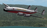
Textures for the Lockheed L-049 Constellation by the team Roland Berger, Volker Boehme, Manfred Jahn, Luis Pallas, Bill Tyne and Stefan Werner. Repaint by Manfred Meyer.
The company Nevada Airmotive bought TWA's L-049 fleet in 1962 for lease and/or resell them. But only fife of the 25 Constellations found new operators .
One of these aircrafts was c/n 2025, built 1945 and used by Lockheed as factory demonstrator until delivered to TWA as NC86504 "Star of France" in 1946. Sold to Nevada Airmotive in 1962 and leased to Futura Airlines and some month later to Paradise Airlines Inc. Oakland, CA. Paradise used the plane together with two further Constellations for flights from Oakland, Salinas, San Jose and other points in California to Lake Tahoe, bringing peoples to Horrah's gambling club there. Sadly N86504 crashed 1. march 1964 nine miles northwest of Lake Tahoe into the mountains with the lost of all 85 on board. Paradise AL then was forced to close down by FAA for failing to conduct a safe operation.
| Filename: | Paradise_Airlines_Lockheed_L049_Constellation.zip |
| License: | Freeware |
| Added: | 11th July 2015, 11:26:45 |
| Downloads: | 124 |
| Author: | Manfred Meyer |
| Size: | 4.14 MB |
| Category: Flight Simulator 2004 - Scenery | |
| Alaska South Slope 4; Selawik PASK |
|
Images related to this file:
File Description:
There are four main northwestern Alaska towns which are serviced by Alaska Airlines, and from which local flights spread out. The northernmost is Barrow. Southwest of Barrow is Kotzebue, then Nome, and the furthest south is Bethel. This series is for the flights from and around Kotzebue, mostly on the South Slope of the Brooks Range of mountains. There will be further additions. Selawik is a village (population now around 760) around 75 miles east of Kotzebue on three of the delta islands of the Selawik River where it flows into Selawik Lake. The delta forms part of the Selawik National Wildlife Refuge for migratory birds. The airfield is just next to the village, with two runways, 3,450 feet of lit gravel aligned 03-21 and 3,100 feet of gravel aligned 09-27. There are scheduled flights by Era (now renamed Ravn) and by Bering Air, both of them originating in Kotzebue and routing east to Noorvik, Kiana, Selawik, etc, and then back again. The AI includes these flights along with Everts Air and GA.
| Filename: | Alaska_South_Slope_4_Selawik_PASK.zip |
| License: | Freeware, limited distribution |
| Added: | 9th October 2016, 04:17:52 |
| Downloads: | 214 |
| Author: | Roger Wensley |
| Size: | 4.34 MB |
| Category: Flight Simulator 2004 - Scenery | |
| Koyuk PAKK in Alaska |
|
Images related to this file:
File Description:
Koyuk is a coastal village around 125 miles east of Nome at the mouth of the Koyuk River, with a population just under 400 living from fishing and the land. The airfield is close by and has a gravel runway aligned 18-36, 3,300 feet long with VASI at both ends. Apart from the airfield itself, and it's buildings, this scenery modifies the local land class, adds village buildings while reducing the village size to reality, and creates a new airfield background. Bering Air and ERA both fly into Deering and are included in the AI. A note here about my scenery making. This is post number 506 and there will not be many more to follow this as I am almost at the end of the photos I either took or found for scenery purposes. There is a limit to what can be located online and I have already been making use of the little there is; eg Unalakleet. So, if you are near an airport (preferably Canadian or Alaskan) and have a camera..... Let me know.
| Filename: | Koyuk_PAKK_in_Alaska.zip |
| License: | Freeware, limited distribution |
| Added: | 15th August 2019, 17:56:50 |
| Downloads: | 142 |
| Author: | Roger Wensley |
| Size: | 3.88 MB |
| Category: Prepar3D V1-4 - Utilities | |
| Flightplan Visualizer 1.10 |
|
Images related to this file:
File Description:
Flightplan Visualizer (FV) version 1.10.0. Copyright 2018-2019 by Pelle F. S. Liljendal ([email protected]), all rights reserved.
FV comes with 300 Commercial-, and +380 BizJet AI pre-imported flightplans which the creators of those flightplans have gracefully allowed me to include with the installer, however you are able to import additional (AI) flightplans if you want to. Once imported these (AI) flightplans can be visualized on a map-view, and the user will be able to search accross all these. Hence you can use the program as inspiration as to which routes to fly. E.g. you can search across all imported flightplans to find all flights in an A321 flying into/out from LDDU, or simply to look for all flights in a Boeing 747-8F.
Simply run the included installer to install the software. The program will be installed into "C:\Program Files (x86)\Flightplan Visualizer" and all datafiles will be installed into: "C:\Users\[UserName]\AppData\Roaming\FlightplanVisualizer". The program comes with a full manual explaining everything, and a 3 page quick manual to get you started. The first 3 times you run the program the quick manual will automatically open. The forum is hosted here: https://forum.aerosoft.com/index.php?/forum/919-flightplan-visualizer/
Version 1.10 Contains the following changes: In the flightplan combo-box at the bottom of the main-form, "Active Search" have been renamed into "Last Search". Picking "Last Search" from the flightplan combo-box, will re-execute the last performed search, and populate the map accordingly. A new entry called "None", have been added flightplan combo-box (at the top of the list). Chosing this item will "deselect" the otherwise current search or selected flightplan, and clear the map of routes. A form have been added to assist enabling/disabling flightplans. Gate-letters/numbers are now by default written using a (5x7) Matrix-"font". If you want to revert to the segment-"font", used in previous versions, simply set the value of the "UseMatrixGateChars" tag in the settings-file to false. changed how the Gate-letters/numbers are written in the round gate-markers on the map. Previously all "chars" had the same width. Now the width is dependant on which sub-elements are in use by each "char" (e.g. a "1" is not as wide as an "8"), as a result the gate letter/number are more easy to read. Zulu- and local-time added to the "Selected airport" group-box in the upper/right corner of the main form. If no airport is selected, or no time-zone is registred for the selected airport, only zulu-time will be displayed. Selections of favorite aircraft can now be saved and loaded.⦠This selection of aircraft can be loaded as a selection of aircraft in the "Search leg" form. Video tutorials can now be accessed from the "Help" menu. These are simply "links" to the actual videos on YouTube, hence will launch the default browser. If you hold SHIFT the url will in stead be copied to the clipboard (e.g. in case you want to upen the link in another browser). In the same manner the "Help" menu now contains a link to the forum. The form with decoded METAR/TAF-messages now shows: name, city, and country/state for the selected station in the caption. This text will also be embedded when copying the content to the clipboard. Likewise UTC/Local-time is also embedded when copying the content to the clipboard as it can be used to show the "age" of the report and convert between UTC and Local -times (based on the difference of UTC- and local-time). The info presented when pressing the "Show Scenery Gates" button on the Airport Info form, can now be copied to the clipboard. Various minor "behind the scenes" changes and optimizations. Added support for additional aircraft: Airbus A220-100 (CS100), Airbus A220-300 (CS300), Boeing 777-8 and Boeing 777-9. Listviews containing both (aircraft) IATA and ICAO-codes now all list them in the following order: IATA, ICAO (both individual sortable). Hovering the mouse over gate-markers the hint window will no show the radius both in meters and feet. Editing gate-info you will now see more info for the gate being edited: Type, Size (meters and feet) and if applicable: airlines. Fixed: Minor bug in relation to how the airport size was calculated. Fixed: IATA/ICAO columns were swapped when choosing Favorite Aircraft. Fixed: Typo on the METAR/TAF-decoder form.
| Filename: | Flightplan_Visualizer_110.zip |
| License: | Freeware, limited distribution |
| Added: | 5th June 2019, 21:20:51 |
| Downloads: | 319 |
| Author: | Pelle Liljendal |
| Size: | 24.81 MB |
| Category: Flight Simulator 2004 - Scenery | |
| Kotzebue PAOT on the northwestern coast of Alaska |
|
Images related to this file:
File Description:
There are four main northwestern Alaska towns which have good airports and are serviced by Alaska Airlines. From these airports local flights connect to nearby villages, "nearby" in Alaska meaning up to 150 miles away. The northernmost is Barrow. Southwest of Barrow is Kotzebue, then Nome, and the furthest south is Bethel. The town of Kotzbue is north of the Bering Strait on the northwestern coast, 320 miles southwest of Barrow. The population is just over 3,000 people. The location was for a long time a base for trading in furs, with three rivers emptying into the sea and providing routes into the interior land and villages; a meeting place between hunters and traders from Russia and elsewhere. The Kotzebue airport is called the Ralph Wien Memorial and has two runways. The modern one is aligned 08-26 and is 5,880 feet of 150 feet wide asphalt built across a shallow lagoon, with an ILS on 08 and PAPI on both ends. The second and older runway is originally military and gravel, aligned 17-35 and 3,786 feet long and used (wind allowing) by the GA planes that park alongside the runway. The prevalent wind is from the west; when the wind is from the east it is generally relatively feeble and with a much lower cloud base, possibly to the ground, hence the need for an ILS. All AI aircraft in FS9 much prefer to use a runway that has an ILS and so will continue to use 08-26 even if the wind is from the south until it reaches 30+ knots, even if they are a Cessna 150 flying VFR. So for AI realism in FS9 a northern or southern wind needs to be a strong one so that the runway is actually used. However, as Alaska Airlines, Northern Air Cargo, and Everts Air also fly to Kotzebue and can only use the east-west runway (as less than 4,000 feet of asphalt would be seriously inconvenient for a Boing 737 or DC6) it is necessary to have the northern or southern wind UNDER 30 knots at the times when they are landing or taking off. Your choice. I suppose a permanent strong wind from the west would be the most realistic on a daily basis, deterring all planes from ever using 17-35. The AI will develop along with further scenery additions in the neighbourhood.
| Filename: | Kotzebue_PAOT_on_the_northwestern_coast_of_Alaska.zip |
| License: | Freeware, limited distribution |
| Added: | 2nd August 2016, 16:47:52 |
| Downloads: | 460 |
| Author: | Roger Wensley |
| Size: | 19.32 MB |
| Category: Prepar3D V1-4 - Aircraft Repaints, Textures and Modifications | |
| Hawker Hurricane Mk.I (Z5664) ML-KNIL |
|
Images related to this file:
File Description:
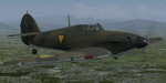
This folder contains a repaint for the Hawker Hurricane by Aeroplane Heaven. It shows Hurricane Z5664 of the Dutch East Indies Air Force.
The KNIL (Dutch East Indies Army) had ordered 12 Mk.I's in 1941 but these were never delivered due to a lack of engines. But 39 Hurricanes destined for the RAF in Singapore were diverted to the Dutch East Indies after the fall of Singapore early 1942. They arrived with HMS Athene in Batavia on February 4th 1942, with 4 more arriving with SS Phrontis from Singapore. These aircraft were then taken into service by the RAF and Dutch. The Dutch aircraft, about 12 retained their RAF colours, national insignia were replaced by the orange triangles.
The Hurricane's equipped two units, of which one aimed especially at the defense of Batavia.
They saw action against the Japanese invaders in February and March 1942. There are no pictures known of these aircraft, but there are some records on them. Some were painted in the RAF desert camouflage, others the European camouflage. Repaint by Jan Kees Blom, based on the paintkit by Aeroplane Heaven.
| Filename: | Hawker_Hurricane_MkI_Z5664_MLKNIL.zip |
| License: | Freeware |
| Added: | 23rd February 2020, 17:07:16 |
| Downloads: | 76 |
| Author: | Jan Kees Blom |
| Size: | 29.75 MB |
| Category: Prepar3D V1-4 - Scenery | |
| Texture Replacement for Phoenix (Arizona) Area Buildings |
|
File Description:
Texture Replacement for Phoenix (Arizona) Area Buildings. There are two buildings in the default scenery for Phoenix, AZ which have needed correction since FSX was released. The original baseball stadium in downtown Phoenix was the Bank One Ballpark, along with the corresponding Bank One Building. Both were absorbed in 2005 by Chase Bank, with name changes (Chase Field and Chase Tower). Also, the local MLB team (Arizona Diamondbacks) changed their colors and logo style around the same time. None of this has been reflected in FSX-through-P3Dv5, as the original FSX textures have carried forward. I'm sure this isn't the only anachronism in the P3D world, but I am fixing my small corner of it. This fix is good for any version of FSX or P3D published to date (DDS textures), just copy the enclosed "scenery" folder into the main folder of your sim of choice, and over-write when prompted. The textures are only 512x512, as are the originals, so I may or may not re-do these in an HD-size in the future, but it will have to be from scratch, so no promises.
| Filename: | Texture_Replacement_for_Phoenix_Arizona_Area_Build.zip |
| License: | Freeware |
| Added: | 23rd January 2021, 20:29:49 |
| Downloads: | 100 |
| Author: | Michael Pearson |
| Size: | 232.63 KB |


© 2001-2026 AVSIM Online
All Rights Reserved
Privacy Policy |