
Where Flight Simulation Enthusiasts Gather from Around the World!
AVSIM Library - Search Results

| Category: Flight Simulator 2004 - AFCAD Files | |
| Airport Expansion for LSZH Zurich (Default FS2004 Only). |

|
File Description:
I decided to expand this airport and make several changes to it, as I was sick of being held in long take off queues and being told to go around all the time with Runway 16/34 being used for take offs and landings all the time (even though 14/32 and 10/32 were open). The changes made are as follows: Runway 14/32 completely withdrawn. Runway 16/34 renamed 16R/34L and now used for departures only. New Runway 16L/34R (8,000 feet) for arrivals only (Equipped with ILS frequencies).
Runway surfaces are now Asphalt. All taxiways are concrete, and comprise of just a centre line (My own personal preference).
148 parking spaces in total. (77 small, 34 medium, 14 large, 5 Cargo, 18 General Aviation). I have decided to assign only Swiss aircraft to gates, as this is obviously the main airline serving this airport. All taxiways have lighting to make it easier to find your way around at night. For FS2004 use only. This AFCAD works best with the 'Airport Environment Upgrade v7' scenery which is available here at AVSIM (aeu7.zip).
| Filename: | Airport_Expansion_for_LSZH_Zurich_Default_FS2004_O.zip |
| License: | Freeware |
| Added: | 27th January 2007, 21:53:40 |
| Downloads: | 2,573 |
| Author: | Chris Horsfield |
| Size: | 515.8 KB |
| Category: Flight Simulator X - Scenery | |
| Frankfurt Main Airport v5 (EDDF) scenery |
|
Images related to this file:
File Description:
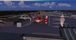
This major release commemorates the opening of the new Northwest Runway. Using ADE 1.50, this scenery package represents the layout of the airport as of October 2011 and includes major updates to the land class data to provide the most realistic environment around the airport.
Other major features include the new 07L/25R runway setup for landings only plus associated navaids, taxiway signs, high-speed taxiways and also reconfigures the other runways as per current operations.
In addition, adds several new features, such as new Gmax models for the DB Schenker and CCT hangars at South Cargo City, a new animated rotating beacon to the North control tower, brand new G gate apron area (9 new parking spots with night lighting) at the site of Terminal 3 as well as a host of other airport buildings and parking lots added on the south side. Other updates include construction work on taxiway Sierra as per real airport as well as latest runway/taxiway textures.
A number of other miscellaneous updates are also featured so see the readme file for more details. Stay tuned for v6 which will add further updates to this freeware FSX Frankfurt scenery.
| Filename: | Frankfurt_Main_Airport_v5_EDDF_scenery.zip |
| License: | Freeware |
| Added: | 25th November 2011, 09:14:18 |
| Downloads: | 2,420 |
| Author: | Mark Aldridge |
| Size: | 4.98 MB |
| Category: Flight Simulator 2004 - Scenery | |
| Smithers CYYD in British Columbia, Canada, Updated |
|
Images related to this file:
File Description:
Made in December 2018 as an update of the original post of 2014, to correct the apron markings, revise the AI, increase the number of GA parking spots, and most importantly to correct the runway lighting by adding the missing approach lights. This scenery is complete and can be installed as-is without first installing the 2014 version. Smithers is in northwest BC, 60 miles east and a bit north of Terrace, and directly east of the southern border of Alaska. The town has a population of 5,500 and is set in a north-south valley between mountains, the most impressive of which is Hudson Bay Mountain to the west. The airport is to the north of the town and has a single runway of 7,544 feet, aligned 33-15. The main user is Central Mountain Air, who are headquartered in Smithers and have a large maintenance hangar there next to the terminal building. The airport has scheduled flights by Central Mountain Air, Jazz, and Hawk Air, which are in the AI. The AI provided here is a new CYYD traffic bgl; in total the AI also includes a Dawson Creek traffic bgl (recently revised and posted) plus a Terrace traffic bgl (which will shortly be revised and posted). An Electra of Conair (who are the largest operator of fire fighting planes in BC, and have re-fill tanks in Smithers) is included and also a HS 748 of Air North.
| Filename: | Smithers_CYYD_in_British_Columbia_Canada_Updated.zip |
| License: | Freeware, limited distribution |
| Added: | 4th January 2019, 18:08:03 |
| Downloads: | 214 |
| Author: | Roger Wensley |
| Size: | 14.22 MB |
| Category: Flight Simulator 2004 - Scenery | |
| Baton Rouge,La. ( KBTR v2 ) |
|
File Description:
FS2004 KBTR Baton Rouge,La. v2.0
This is an updated version from my old EZ Mega KBTR version 1.0
This Scenery is optimized for use with Ultimate Terrain USA,but should work OK with default land scenery.
This package features a lot of objects around the city of Baton Rouge, such as an accurate rendition of the 473foot tall State capital Building, Cortana mall,Seigen Village Mall,strip malls,banks,restaurants,gas stations,Chemical plants,River Barge Traffic,USS Kidd Destroyer,the two casino boats,the Marriott Hotel off College drive,Louisiana State Police headquarters with its own AFCAD and Helo pads and lots of other stuff.This version does not feature my custom built terminal and hangers,that will come in version 3.
The Airport AFCAD has been once again reworked as well to reflect the newly lengthened Rwy 22R-4L and other stuff.
This has been my test bed for the upcoming version 3 release which will be released by Christmas hopefully.
In the meantime,enjoy this new version equipped with familiar landmarks.
As Always...Enjoy!!!
| Filename: | Baton_RougeLa__KBTR_v2_.zip |
| License: | Freeware |
| Added: | 11th October 2008, 02:15:38 |
| Downloads: | 2,866 |
| Author: | Joe DeGregorio |
| Size: | 13.04 MB |
| Category: Flight Simulator X - Gauges | |
| TCAS and Traffic Display Gauge V1.0 |
|
Images related to this file:
File Description:
This TCAS and Traffic Display Gauge Version 1.0 has been developed for the FSX Flight Simulator SP1/2. It should also work with Acceleration. The functionality for the TCAS part is based on general specs for commercial aircrafts. It does not provide in detail the function for a specific aircraft model. It is a generic gauge, and can be simply added to any aircraft as a standalone pop-up window.
In addition the gauge provides a AI traffic display in the ranges of 10,20, and 40 miles.
Within this display mode, no TCAS rules are valid, which means all AI aircraft are displayed independent of any altitude or distance.
For installation and functional description look at the doc inside the Zip.
CREDIT goes to:
Stefan Schneider for his support on special XML issues and TCAS functionality.
Bob Familton for his review of the documentation and testing for SP1 FSX.
Doug Dawson for his dsd-XML-sound interface in order to generate the sounds.
| Filename: | TCAS_and_Traffic_Display_Gauge_V10.zip |
| License: | Freeware |
| Added: | 13th September 2010, 12:58:33 |
| Downloads: | 1,726 |
| Author: | Dietmar Loleit |
| Size: | 979.49 KB |
| Category: Flight Simulator X - Scenery | |
| Pagasa Island, Philippines |
|
Images related to this file:
File Description:
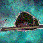
Pagasa Island is a jewel in the South China Sea. It is the one pictured - an emerald splash in an azure sea slashed by a coral runway - whenever new collisions or confrontations are reported in the news for the region. Occupied continuously by the Philippines since 1971, historical use dates back to the Han dynasty, which many believe forms the basis of the Chinese claim to the island. Each country has it's own interpretation of international law and the Filipinos are clearly banking on the precedence of continuous occupation, at no small expense, as Rancudo Field is the farthest airport from Manila within the Philippine sphere of control.
Surprisingly, the geography of the island serves to capture and retain rainwater, although the aquifer is stagnant and the water must be treated for consumption. Sea life remains abundant, poachers take coral heads and sea turtles. There is a solar farm and recently installed solar street lights, fuel for the generators is a precious commodity this far from the mainland.
Sadly, nature may solve the struggle for possession by withdrawing the island from the arena. It is believed that the construction of the runway may have compromised the islands basic integrity, allowing it to crumble into the sea. Whatever the cause, the evidence is clear. Bunkers built during the Japanese occupation in WWII are already slipping beneath the waves and the rate of salt water encroachment has been recorded at close to 6" per day.
There are some things to explore, the grounded BRP Laneo Del Norte to the west; over to the north near the resort grounds are a dugout fishing canoe and some authentic Philippine bangka boats; you may want to load up and head east to do some low warning passes over the Chinese fishing fleet. Standing at the east end of the field, you can just barely spot the China Coast Guard cutter's smoke on the horizon.
The tower is marked by a bright strobe that fires once every five seconds and at night it is bright enough to guide you back to the island from the distance of the fleet. There are no published procedures and the tower is not staffed. Airport ICAO is RPPN.
| Filename: | Pagasa_Island_Philippines.zip |
| License: | Freeware, limited distribution |
| Added: | 10th May 2014, 12:21:19 |
| Downloads: | 1,851 |
| Author: | Rick Keller |
| Size: | 16.17 MB |
| Category: Flight Simulator X - AFCAD Files | |
| PAKT - Ketchikan airport - Ketchikan, Alaska - USA |
|
Images related to this file:
File Description:
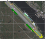
This AFCAD requires payware "Ultimate Terrain Alaska X"!! It will not work without it as it is built on the underlying terrain features and the included file "PAKT_AP.BGL" which has to be renamed or moved to a folder outside the FSX terrain environment. The original file included some errors which I tried to correct. This patch is published with permission.
Changes: The apron layout is corrected including now taxiway "C" leading to GA parking. The pavement has been changed to asphalt as it appears to be when taking aerial pictures as template. The runway got the proper overruns at both sides and the position of the ILS glideslope and localizer has been corrected as well as the DME. The layout of the airport building arrangement including the tower should be now closer to the real world and I added a working jetway. However, I used FSX default objects. As I was dependent on quite rare layout information I just tried to adjust the taxi paths and parking spots probably closer to the reality than before but I did not put any effort to name the parking spots like in real life nor did I take care for taxi signs (only the runway entries got such).
| Filename: | PAKT__Ketchikan_airport__Ketchikan_Alaska__USA.zip |
| License: | Check within download |
| Added: | 25th May 2013, 19:40:38 |
| Downloads: | 439 |
| Author: | Axel Birsul |
| Size: | 1.28 MB |
| Category: Flight Simulator X - Flight Plans | |
| SIDSTAR for KJFK John F Kennedy Intl, New York |
|
File Description:
SIDSTAR Procedure File for KJFK for Cycle 1204/1205 (05APR12-31MAY12) based on FAA National Data from National Flight Data Center, issued every 56d (Two Navigraph Cycles). These procedures include the following enhancements: All procedures are included as-published by the FAA and they are expanded to replace VECTORS with realistic route segments for use in a non-ATC environment (ie not using VATSIM or other service). All STARs include routing from the arrival to the final approach fix of the approach and all SIDs are expanded to include routing from the runway to the departure gate, except where noted in the file header. Each procedure file includes a text header that provides information on all the procedures for that location.
The KJFK procedure file includes all published SIDs plus routes to often filed departure gates such as BAYYS, BERGH, COATE, CUTOX DIXIE GAYEL LINND NEION and RBV. All published STARs are included and routes are provided to all ILS as well as GPS13L and Visual 22L. All published approaches are provided including two Charted Visual Approaches BELMONT VIS22L and PARKWAY VIS13L/R.
For PMDG 737NG/737NGX/747-400/747-400X/MD-11FS9/MD-11FSX/BAeJS41
| Filename: | SIDSTAR_for_KJFK_John_F_Kennedy_Intl_New_York.zip |
| License: | Freeware |
| Added: | 21st April 2012, 22:21:49 |
| Downloads: | 351 |
| Author: | Dan Downs |
| Size: | 14.09 KB |
| Category: Miscellaneous Files - Miscellaneous Files | |
| FSMMoving Map v1.1.0 |
|
File Description:
FSMMovingMap 1.1.0 - Compatible with both FS2002 and FS2004
FSM Moving Map is a Freeware software with some neat features. With proper road maps, you will be able to find your road (or lack of) in FS environment, or fly at ease using Sectional or terminal charts. The concept is very simple: you, the user define all the maps... once you are flying, FSMMM will try to locate the best map available, and display it on screen. This can be very useful during VFR Flights.
One of our beta user has described it as "flying like the rich people with fancy GPS units sporting colour map displays" - 'nuff said.
On local PC, this map can be used with FS2004 Kneeboard, or with "MovingMap Launcher". This software can also integrate with FlightSim Manager (v2.8 and above), and work over the network using FSM Lanview (so you can fly on one machine while the map runs on a different PC).
You can find the latest version from: http://www.ranainside.com/
Programmer
Rana Hossain
[email protected]
24 February 2005
| Filename: | FSMMoving_Map_v110.zip |
| License: | Freeware, limited distribution |
| Added: | 24th February 2005, 05:00:56 |
| Downloads: | 12,057 |
| Author: | Rana Hossain |
| Size: | 798.33 KB |
| Category: Prepar3D V1-4 - Scenery | |
| ENRA - Mo I Rana Rossvoll Airport - Nordland, Norway |
|
Images related to this file:
File Description: The Mo i Rana airport, Rossvoll is a North Norwegian airport in the county of Nordland. It is located about ten kilometers northeast of the city Mo i Rana. Operator of the airport is the Norwegian state-owned company Avinor. The Mo i Rana Airport is currently served only by the Norwegian regional airline Wideroe. Scheduled flights go to an from Bodo, Bronnoysund, Mosjoen, Rorvik, Sandnessjoen and Trondheim. The P3D scenery is a partly rework of my FSX-ENRA scenery: Especially the apron lights are made completely new.
The environment of the airport is adapted by new landclasses. The airport has a photo background in two variants, covering all four seasons of spring,summer, autumn and winter. The buildings in this scenery come from the fantastic XPlane scenery of Bert alias "almosquito" who kindly gave me the permission to convert them for my FSX /P3D scenery. But there are also some objects taken from two very popular freeware libraries. If these libraries are not installed, several objects are not visible! Please have a look to the readme_enra.txt. The screenshots are taken from the FSX version. But the P3D version looks quite similar.
| Filename: | ENRA__Mo_I_Rana_Rossvoll_Airport__Nordland_Norway.zip |
| License: | Freeware |
| Added: | 2nd April 2019, 18:48:29 |
| Downloads: | 540 |
| Author: | Wolfgang Allers |
| Size: | 155.53 MB |
© 2001-2026 AVSIM Online
All Rights Reserved
Privacy Policy |